Bridge Statistics for Staunton, Illinois (IL)
Condition, Traffic, Stress, Structural Evaluation, Project Costs
- National Bridge Inventory (NBI) Statistics
- 17Number of bridges
- 236ft / 71.6mTotal length
- $765,000Total costs
- 96,250Total average daily traffic
- 27,709Total average daily truck traffic
- National Bridge Inventory (NBI) Registered Bridges for Staunton
- No street view available for this location
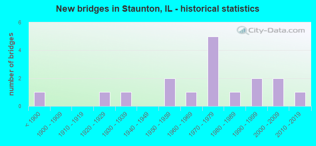
- New bridges - historical statistics
- 1Before 1900
- 11920-1929
- 11930-1939
- 21950-1959
- 11960-1969
- 51970-1979
- 11980-1989
- 21990-1999
- 22000-2009
- 12010-2019

- Reconstructed bridges - Historical Statistics
- 11980-1989
- 31990-1999


- Bridge Condition - Deck
- 66.7%Good
- 33.3%Satisfactory

- Bridge Condition - Superstructure
- 66.7%Good
- 25.0%Satisfactory
- 8.3%Fair

- Bridge Condition - Substructure
- 50.0%Very good
- 8.3%Good
- 25.0%Satisfactory
- 16.7%Fair

- Bridge Condition - Channel
- 66.7%Very good
- 11.1%Good
- 11.1%Satisfactory
- 11.1%Fair
Find on map >> Show street view
Structure Number: 590009, Location: 2.0 M N STAUNTON (Lat: 39.046292, Lng: -89.806461), Route carried "on" structure: State highway 4, Year Built: 1959, Year Reconstructed: 1998, Status: Open, Structure Length: 6.93m (22.74ft), Average Daily Traffic: 2,800 (year 2021), Truck Traffic: 5%, Average Future Daily Traffic: 3,323 (year 2032), Design Load: HS 20, Features Intersected: NSRR
Minimum Vertical Clearance: 30+ m (98+ ft), Kilometerpoint: 170.312, Lanes on structure: 2, Base Highway Network: Yes, Owner: State Highway Agency, Approaching Roadway Width: 10.8m (35.4ft), Skew: 5 degrees, Material/Design: Steel continuous, Design/Construction: Stringer/Multi-beam, Number Of Spans In Main Unit: 3, Length of Maximum Span: 26.3m (86.3ft), Curb-To-Curb Width: 10.8m (35.4ft), Out-to-Out Width: 11.8m (38.7ft)
Condition: Deck: Good, Superstructure: Fair, Substructure: Satisfactory, Operating Rating: 89.1 metric tons, Method Used To Determine Operating Rating: Load Factor (LF) rating reported by rating factor (RF) method using MS18 loading, Inventory Rating: 49.6 metric tons, Method Used To Determine Inventory Rating: Load Factor (LF) rating reported by rating factor (RF) method using MS18 loading, Structural Evaluation: Somewhat better than minimum adequacy, Deck Geometry: Somewhat better than minimum adequacy, Underclear: Equal to present minimum criteria, Approach Roadway Alignment: Equal to present desirable criteria, Length Of Structure Improvement: 6.95m (22.80ft), Designated Inspection Frequency: Every 24 months, Inspection Date: November 2020, Bridge Improvement Cost: $510,000, Roadway Improvement Cost: $51,000, Total Project Cost: $765,000, Deck Structure Type: Concrete Cast-file-Place, Wearing Surface/Protective System: Wearing Surface: Other, Deck Protection: Epoxy Coated Reinforcing
Find on map >> Show street view
Structure Number: 59001, Location: 1.0 M N STAUNTON (Lat: 39.036614, Lng: -89.801961), Route carried "on" structure: State highway 4, Year Built: 1921, Year Reconstructed: 1997, Status: Open, Structure Length: 9.42m (30.91ft), Average Daily Traffic: 2,800 (year 2021), Truck Traffic: 5%, Average Future Daily Traffic: 3,323 (year 2032), Design Load: HS 20, Features Intersected: CAHOKIA CREEK
Minimum Vertical Clearance: 30+ m (98+ ft), Kilometerpoint: 169.137, Lanes on structure: 2, Base Highway Network: Yes, Owner: State Highway Agency, Approaching Roadway Width: 10.8m (35.4ft), Skew: 2 degrees, Material/Design: Steel continuous, Design/Construction: Stringer/Multi-beam, Number Of Spans In Main Unit: 4, Length of Maximum Span: 26.0m (85.3ft), Curb-To-Curb Width: 10.8m (35.4ft), Out-to-Out Width: 11.8m (38.7ft)
Condition: Deck: Satisfactory, Superstructure: Good, Substructure: Good, Channel: Very good, Operating Rating: 75.2 metric tons, Method Used To Determine Operating Rating: Load Factor (LF) rating reported by rating factor (RF) method using MS18 loading, Inventory Rating: 45.0 metric tons, Method Used To Determine Inventory Rating: Load Factor (LF) rating reported by rating factor (RF) method using MS18 loading, Structural Evaluation: Better than present minimum criteria, Deck Geometry: Somewhat better than minimum adequacy, Waterway Adequacy: Superior to present desirable criteria, Approach Roadway Alignment: Equal to present desirable criteria, Designated Inspection Frequency: Every 48 months, Inspection Date: Febuary 2020, Deck Structure Type: Concrete Cast-file-Place, Wearing Surface/Protective System: Deck Protection: Epoxy Coated Reinforcing
Find on map >> Show street view
Structure Number: 590044, Location: .8M N STAUNTON INTCH (Lat: 39.031761, Lng: -89.753711), Route carried "on" structure: County highway , Year Built: 1973, Status: Open, Structure Length: 7.74m (25.39ft), Average Daily Traffic: 2,000 (year 2021), Truck Traffic: 3%, Average Future Daily Traffic: 2,366 (year 2032), Design Load: HS 20, Features Intersected: I-55, Facility Carried by Structure: WILLIAMSON RD/SBI
Minimum Vertical Clearance: 30+ m (98+ ft), Kilometerpoint: 0.515, Lanes on structure: 2, Lanes under structure: 4, Owner: State Highway Agency, Approaching Roadway Width: 13.4m (44.0ft), Material/Design: Steel continuous, Design/Construction: Stringer/Multi-beam, Number Of Spans In Main Unit: 2, Number Of Approach Spans: 2, Length of Maximum Span: 30.8m (101.0ft), Curb-To-Curb Width: 13.0m (42.7ft), Out-to-Out Width: 14.0m (45.9ft)
Condition: Deck: Good, Superstructure: Satisfactory, Substructure: Satisfactory, Operating Rating: 92.3 metric tons, Method Used To Determine Operating Rating: Load Factor (LF) rating reported by rating factor (RF) method using MS18 loading, Inventory Rating: 44.1 metric tons, Method Used To Determine Inventory Rating: Load Factor (LF) rating reported by rating factor (RF) method using MS18 loading, Structural Evaluation: Equal to present minimum criteria, Deck Geometry: Better than present minimum criteria, Underclear: Somewhat better than minimum adequacy, Approach Roadway Alignment: Equal to present desirable criteria, Designated Inspection Frequency: Every 24 months, Inspection Date: August 2021, Deck Structure Type: Concrete Cast-file-Place, Wearing Surface/Protective System: Wearing Surface: Bituminous, Membrane: Built-up
Find on map >> Show street view
Structure Number: 590045, Location: I-55 INT @ STAUNTON (Lat: 39.020881, Lng: -89.750058), Route carried "on" structure: Other road , Year Built: 1975, Status: Open, Structure Length: 7.68m (25.20ft), Average Daily Traffic: 4,050 (year 2021), Truck Traffic: 13%, Average Future Daily Traffic: 3,424 (year 2032), Design Load: HS 20, Features Intersected: FAI 55, Facility Carried by Structure: STAUNTON CONNECTOR
Minimum Vertical Clearance: 30+ m (98+ ft), Kilometerpoint: 3.846, Lanes on structure: 2, Lanes under structure: 4, Base Highway Network: Yes, Owner: State Highway Agency, Approaching Roadway Width: 14.6m (47.9ft), Material/Design: Steel continuous, Design/Construction: Stringer/Multi-beam, Number Of Spans In Main Unit: 2, Number Of Approach Spans: 2, Length of Maximum Span: 33.2m (108.9ft), Curb-To-Curb Width: 19.7m (64.6ft), Out-to-Out Width: 20.7m (67.9ft)
Condition: Deck: Satisfactory, Superstructure: Satisfactory, Substructure: Satisfactory, Operating Rating: 60.3 metric tons, Method Used To Determine Operating Rating: Load Factor (LF) rating reported by rating factor (RF) method using MS18 loading, Inventory Rating: 29.2 metric tons, Method Used To Determine Inventory Rating: Load Factor (LF) rating reported by rating factor (RF) method using MS18 loading, Structural Evaluation: Equal to present minimum criteria, Deck Geometry: Superior to present desirable criteria, Underclear: Somewhat better than minimum adequacy, Approach Roadway Alignment: Equal to present desirable criteria, Designated Inspection Frequency: Every 24 months, Inspection Date: June 2021, Deck Structure Type: Concrete Cast-file-Place, Wearing Surface/Protective System: Wearing Surface: Bituminous, Membrane: Built-up
Find on map >> Show street view
Structure Number: 593011, Location: 3 M S WILSONVILLE (Lat: 39.020325, Lng: -89.861511), Route carried "on" structure: County highway , Year Built: 2009, Status: Open, Structure Length: 5.99m (19.65ft), Average Daily Traffic: 125 (year 2021), Truck Traffic: 7%, Average Future Daily Traffic: 76 (year 2032), Design Load: HS 20, Features Intersected: W FRK CAHOKIA CR, Facility Carried by Structure: TR 477
Minimum Vertical Clearance: 30+ m (98+ ft), Kilometerpoint: 1.255, Lanes on structure: 2, Owner: Town or Township Highway Agency, Approaching Roadway Width: 5.5m (18.0ft), Material/Design: Prestressed concrete, Design/Construction: Box Beam or Girders - Multiple, Number Of Spans In Main Unit: 3, Length of Maximum Span: 19.8m (65.0ft), Curb-To-Curb Width: 8.2m (26.9ft), Out-to-Out Width: 8.2m (26.9ft)
Condition: Deck: Good, Superstructure: Good, Substructure: Very good, Channel: Very good, Operating Rating: 53.8 metric tons, Method Used To Determine Operating Rating: Assigned rating based on Load Factor Design (LFD) reported by rating factor (RF) using MS18 loading, Inventory Rating: 32.4 metric tons, Method Used To Determine Inventory Rating: Assigned rating based on Load Factor Design (LFD) reported by rating factor (RF) using MS18 loading, Structural Evaluation: Better than present minimum criteria, Deck Geometry: Somewhat better than minimum adequacy, Waterway Adequacy: Superior to present desirable criteria, Approach Roadway Alignment: Equal to present desirable criteria, Designated Inspection Frequency: Every 48 months, Inspection Date: January 2021, Deck Structure Type: Concrete Precast Panels
Find on map >> Show street view
Structure Number: 593014, Location: 1.0 MI W STAUNTON (Lat: 39.030644, Lng: -89.817422), Route carried "on" structure: County highway , Year Built: 1961, Year Reconstructed: 1994, Status: Open, Structure Length: 5.00m (16.40ft), Average Daily Traffic: 900 (year 2021), Truck Traffic: 6%, Average Future Daily Traffic: 1,108 (year 2032), Design Load: HS 20, Features Intersected: CAHOKIA CREEK, Facility Carried by Structure: FAS 736
Minimum Vertical Clearance: 30+ m (98+ ft), Kilometerpoint: 29.418, Lanes on structure: 2, Owner: County Highway Agency, Approaching Roadway Width: 11.0m (36.1ft), Skew: 1 degrees, Material/Design: Steel continuous, Design/Construction: Stringer/Multi-beam, Number Of Spans In Main Unit: 3, Length of Maximum Span: 16.2m (53.1ft), Curb-To-Curb Width: 9.1m (29.9ft), Out-to-Out Width: 9.1m (29.9ft)
Condition: Deck: Satisfactory, Superstructure: Good, Substructure: Fair, Channel: Good, Operating Rating: 48.6 metric tons, Method Used To Determine Operating Rating: Load Factor (LF) rating reported by rating factor (RF) method using MS18 loading, Inventory Rating: 29.2 metric tons, Method Used To Determine Inventory Rating: Load Factor (LF) rating reported by rating factor (RF) method using MS18 loading, Structural Evaluation: Somewhat better than minimum adequacy, Deck Geometry: Equal to present minimum criteria, Waterway Adequacy: Equal to present desirable criteria, Approach Roadway Alignment: Equal to present desirable criteria, Designated Inspection Frequency: Every 24 months, Inspection Date: January 2021, Deck Structure Type: Concrete Cast-file-Place
Find on map >> Show street view
Structure Number: 593513, Location: 3 MI W STAUTON (Lat: 39.005883, Lng: -89.864178), Route carried "on" structure: County highway , Year Built: 1995, Status: Open, Structure Length: 3.14m (10.30ft), Average Daily Traffic: 75 (year 2021), Truck Traffic: 16%, Average Future Daily Traffic: 76 (year 2032), Design Load: HS 20, Features Intersected: CAHOKIA CREEK, Facility Carried by Structure: TR 473
Minimum Vertical Clearance: 30+ m (98+ ft), Kilometerpoint: 13.566, Lanes on structure: 2, Owner: Town or Township Highway Agency, Approaching Roadway Width: 6.1m (20.0ft), Skew: 2 degrees, Material/Design: Prestressed concrete, Design/Construction: Box Beam or Girders - Multiple, Number Of Spans In Main Unit: 3, Length of Maximum Span: 12.2m (40.0ft), Curb-To-Curb Width: 8.5m (27.9ft), Out-to-Out Width: 8.5m (27.9ft)
Condition: Deck: Good, Superstructure: Good, Substructure: Very good, Channel: Very good, Operating Rating: 44.1 metric tons, Method Used To Determine Operating Rating: Assigned rating based on Load Factor Design (LFD) reported by rating factor (RF) using MS18 loading, Inventory Rating: 32.4 metric tons, Method Used To Determine Inventory Rating: Assigned rating based on Load Factor Design (LFD) reported by rating factor (RF) using MS18 loading, Structural Evaluation: Better than present minimum criteria, Deck Geometry: Better than present minimum criteria, Waterway Adequacy: Better than present minimum criteria, Approach Roadway Alignment: Equal to present desirable criteria, Designated Inspection Frequency: Every 48 months, Inspection Date: January 2021, Deck Structure Type: Concrete Precast Panels, Wearing Surface/Protective System: Wearing Surface: Gravel
Find on map >> Show street view
Structure Number: 593518, Location: 1 MI W STAUTON (Lat: 39.016969, Lng: -89.823750), Route carried "on" structure: County highway , Year Built: 2002, Status: Open, Structure Length: 7.20m (23.62ft), Average Daily Traffic: 250 (year 2021), Truck Traffic: 2%, Average Future Daily Traffic: 151 (year 2032), Design Load: HS 20, Features Intersected: CAHOKIA CRK., Facility Carried by Structure: TR 477C
Minimum Vertical Clearance: 30+ m (98+ ft), Kilometerpoint: 4.667, Lanes on structure: 2, Owner: Town or Township Highway Agency, Approaching Roadway Width: 6.1m (20.0ft), Skew: 3 degrees, Material/Design: Prestressed concrete, Design/Construction: Box Beam or Girders - Multiple, Number Of Spans In Main Unit: 3, Length of Maximum Span: 23.8m (78.1ft), Curb-To-Curb Width: 8.2m (26.9ft), Out-to-Out Width: 8.2m (26.9ft)
Condition: Deck: Satisfactory, Superstructure: Satisfactory, Substructure: Very good, Channel: Very good, Operating Rating: 44.1 metric tons, Method Used To Determine Operating Rating: Assigned rating based on Load Factor Design (LFD) reported by rating factor (RF) using MS18 loading, Inventory Rating: 32.4 metric tons, Method Used To Determine Inventory Rating: Assigned rating based on Load Factor Design (LFD) reported by rating factor (RF) using MS18 loading, Structural Evaluation: Equal to present minimum criteria, Deck Geometry: Somewhat better than minimum adequacy, Waterway Adequacy: Equal to present desirable criteria, Approach Roadway Alignment: Equal to present desirable criteria, Designated Inspection Frequency: Every 24 months, Inspection Date: January 2021, Deck Structure Type: Concrete Precast Panels
Find on map >> Show street view
Structure Number: 59601, Location: STAUNTON RESERVOIR (Lat: 39.042542, Lng: -89.781111), Route carried "on" structure: County highway , Year Built: 1996, Status: Open, Structure Length: 2.29m (7.51ft), Average Daily Traffic: 200 (year 2021), Truck Traffic: 2%, Average Future Daily Traffic: 604 (year 2032), Design Load: HS 20, Features Intersected: STAUNTON RESERVOIR, Facility Carried by Structure: TR 457
Minimum Vertical Clearance: 30+ m (98+ ft), Kilometerpoint: 0.740, Lanes on structure: 2, Owner: City or Municipal Highway Agency, Approaching Roadway Width: 6.1m (20.0ft), Skew: 1 degrees, Material/Design: Prestressed concrete, Design/Construction: Box Beam or Girders - Multiple, Number Of Spans In Main Unit: 1, Length of Maximum Span: 22.1m (72.5ft), Curb-To-Curb Width: 9.1m (29.9ft), Out-to-Out Width: 9.1m (29.9ft)
Condition: Deck: Good, Superstructure: Good, Substructure: Very good, Channel: Very good, Operating Rating: 54.1 metric tons, Method Used To Determine Operating Rating: Field evaluation and documented engineering judgment, Inventory Rating: 32.4 metric tons, Method Used To Determine Inventory Rating: Field evaluation and documented engineering judgment, Structural Evaluation: Better than present minimum criteria, Deck Geometry: Equal to present minimum criteria, Waterway Adequacy: Equal to present desirable criteria, Approach Roadway Alignment: Equal to present desirable criteria, Designated Inspection Frequency: Every 48 months, Inspection Date: January 2021, Deck Structure Type: Concrete Precast Panels, Wearing Surface/Protective System: Wearing Surface: Bituminous
Find on map >> Show street view
Structure Number: 603008, Location: 4MI E PRRTWN (Lat: 38.983683, Lng: -89.851153), Route carried "on" structure: County highway , Year Built: 1953, Year Reconstructed: 2001, Status: Open, Structure Length: 6.04m (19.82ft), Average Daily Traffic: 1,650 (year 2021), Truck Traffic: 8%, Average Future Daily Traffic: 1,643 (year 2032), Design Load: HS 20, Features Intersected: CAHOKIA CK, Facility Carried by Structure: FAS 2735
Minimum Vertical Clearance: 30+ m (98+ ft), Kilometerpoint: 10.911, Lanes on structure: 2, Owner: County Highway Agency, Approaching Roadway Width: 12.8m (42.0ft), Skew: 2 degrees, Material/Design: Prestressed concrete, Design/Construction: Box Beam or Girders - Multiple, Number Of Spans In Main Unit: 3, Length of Maximum Span: 23.2m (76.1ft), Curb-To-Curb Width: 12.9m (42.3ft), Out-to-Out Width: 12.9m (42.3ft)
Condition: Deck: Good, Superstructure: Good, Substructure: Very good, Channel: Fair, Operating Rating: 44.4 metric tons, Method Used To Determine Operating Rating: Load Factor (LF) rating reported by rating factor (RF) method using MS18 loading, Inventory Rating: 32.4 metric tons, Method Used To Determine Inventory Rating: Load Factor (LF) rating reported by rating factor (RF) method using MS18 loading, Structural Evaluation: Better than present minimum criteria, Deck Geometry: Better than present minimum criteria, Waterway Adequacy: Equal to present desirable criteria, Approach Roadway Alignment: Equal to present desirable criteria, Designated Inspection Frequency: Every 48 months, Inspection Date: April 2021, Deck Structure Type: Concrete Precast Panels, Wearing Surface/Protective System: Wearing Surface: Bituminous, Membrane: Built-up
Find on map >> Show street view
Structure Number: 603251, Location: 1.9 M W OFSTAUNTON (Lat: 38.998453, Lng: -89.837225), Route carried "on" structure: County highway , Year Built: 1984, Status: Open, Structure Length: 8.78m (28.81ft), Average Daily Traffic: 150 (year 2021), Truck Traffic: 9%, Average Future Daily Traffic: 133 (year 2032), Design Load: HS 20, Features Intersected: CAHOKIA CREEK, Facility Carried by Structure: VFW RD/ TR 3
Minimum Vertical Clearance: 30+ m (98+ ft), Kilometerpoint: 3.235, Lanes on structure: 2, Owner: County Highway Agency, Approaching Roadway Width: 6.7m (22.0ft), Skew: 2 degrees, Material/Design: Prestressed concrete, Design/Construction: Box Beam or Girders - Multiple, Number Of Spans In Main Unit: 5, Length of Maximum Span: 20.1m (65.9ft), Curb-To-Curb Width: 9.0m (29.5ft), Out-to-Out Width: 9.1m (29.9ft)
Condition: Deck: Good, Superstructure: Good, Substructure: Fair, Channel: Satisfactory, Operating Rating: 44.4 metric tons, Method Used To Determine Operating Rating: Assigned rating based on Load Factor Design (LFD) reported by rating factor (RF) using MS18 loading, Inventory Rating: 32.4 metric tons, Method Used To Determine Inventory Rating: Assigned rating based on Load Factor Design (LFD) reported by rating factor (RF) using MS18 loading, Structural Evaluation: Somewhat better than minimum adequacy, Deck Geometry: Equal to present minimum criteria, Waterway Adequacy: Equal to present desirable criteria, Approach Roadway Alignment: Equal to present desirable criteria, Designated Inspection Frequency: Every 24 months, Inspection Date: April 2021, Deck Structure Type: Concrete Precast Panels, Wearing Surface/Protective System: Wearing Surface: Gravel
Find on map >> Show street view
Structure Number: 603357, Location: 0.5MI SW STAUNTON (Lat: 38.991611, Lng: -89.810792), Route carried "on" structure: County highway , Year Built: 2011, Status: Open, Structure Length: 1.37m (4.49ft), Average Daily Traffic: 100 (year 2021), Truck Traffic: 3%, Average Future Daily Traffic: 53 (year 2032), Design Load: HS 25 or greater, Features Intersected: TRIB TO CAHOKIA CK, Facility Carried by Structure: TR 244
Minimum Vertical Clearance: 30+ m (98+ ft), Kilometerpoint: 0.837, Lanes on structure: 2, Owner: Town or Township Highway Agency, Approaching Roadway Width: 7.0m (23.0ft), Material/Design: Prestressed concrete, Design/Construction: Box Beam or Girders - Multiple, Number Of Spans In Main Unit: 1, Length of Maximum Span: 13.0m (42.7ft), Curb-To-Curb Width: 9.2m (30.2ft), Out-to-Out Width: 9.2m (30.2ft)
Condition: Deck: Good, Superstructure: Good, Substructure: Very good, Channel: Very good, Operating Rating: 44.1 metric tons, Method Used To Determine Operating Rating: Assigned rating based on Load Factor Design (LFD) reported by rating factor (RF) using MS18 loading, Inventory Rating: 32.4 metric tons, Method Used To Determine Inventory Rating: Assigned rating based on Load Factor Design (LFD) reported by rating factor (RF) using MS18 loading, Structural Evaluation: Better than present minimum criteria, Deck Geometry: Better than present minimum criteria, Waterway Adequacy: Equal to present desirable criteria, Approach Roadway Alignment: Equal to present desirable criteria, Designated Inspection Frequency: Every 48 months, Inspection Date: May 2021, Deck Structure Type: Concrete Precast Panels, Wearing Surface/Protective System: Wearing Surface: Bituminous, Membrane: Built-up
Find on map >> Show street view
Structure Number: 590043, Location: 1.1MI N STAUNTON INT (Lat: 39.036181, Lng: -89.754997), Route carried "under" structure: Interstate 55, Year Built: 1974, Structure Length: 0. m, Average Daily Traffic: 26,000 (year 2021), Truck Traffic: 34%, Features Intersected: FAI 55, Facility Carried by Structure: Norfolk Southern R
Minimum Vertical Clearance: 5.61m (18.41ft), Kilometerpoint: 66.834, Lanes under structure: 4, Material/Design: Steel, Design/Construction: Girder and Floorbeam System, Length of Maximum Span: 39.6m (129.9ft)
Find on map >> Show street view
Structure Number: 590044, Location: .8M N STAUNTON INTCH (Lat: 39.032006, Lng: -89.753211), Route carried "under" structure: Interstate 55, Year Built: 1973, Structure Length: 0. m, Average Daily Traffic: 26,000 (year 2021), Truck Traffic: 34%, Features Intersected: I-55, Facility Carried by Structure: WILLIAMSON RD/SBI
Minimum Vertical Clearance: 4.90m (16.08ft), Kilometerpoint: 66.351, Lanes on structure: 2, Lanes under structure: 4, Material/Design: Steel continuous, Design/Construction: Stringer/Multi-beam, Length of Maximum Span: 30.8m (101.0ft)
Find on map >> Show street view
Structure Number: 590045, Location: I-55 INT @ STAUNTON (Lat: 39.020886, Lng: -89.749472), Route carried "under" structure: Interstate 55, Year Built: 1975, Structure Length: 0. m, Average Daily Traffic: 26,000 (year 2021), Truck Traffic: 34%, Features Intersected: FAI 55, Facility Carried by Structure: STAUNTON CONNECTOR
Minimum Vertical Clearance: 4.93m (16.17ft), Kilometerpoint: 65.080, Lanes on structure: 2, Lanes under structure: 4, Material/Design: Steel continuous, Design/Construction: Stringer/Multi-beam, Length of Maximum Span: 33.2m (108.9ft)
Find on map >> Show street view
Structure Number: 5999, Location: 2 M ENE STAUNTON (Lat: 39.040431, Lng: -89.750581), Route carried "under" structure: County highway , Year Built: 1938, Structure Length: 0. m, Average Daily Traffic: 2,900 (year 2021), Truck Traffic: 3%, Features Intersected: FAS 1766, Facility Carried by Structure: N&W RR
Minimum Vertical Clearance: 4.22m (13.85ft), Kilometerpoint: 1.368, Lanes under structure: 4, Material/Design: Steel, Design/Construction: Girder and Floorbeam System, Length of Maximum Span: 29.3m (96.1ft)
Find on map >> Show street view
Structure Number: 599911, Location: WEST EDGE STAUNTON (Lat: 39.012986, Lng: -89.803450), Route carried "under" structure: County highway , Year Built: 1891, Structure Length: 0. m, Average Daily Traffic: 250 (year 2021), Truck Traffic: 2%, Features Intersected: TR 0477, Facility Carried by Structure: C&NW RR
Minimum Vertical Clearance: 8.69m (28.51ft), Kilometerpoint: 6.598, Lanes under structure: 2, Material/Design: Steel, Design/Construction: Girder and Floorbeam System, Length of Maximum Span: 21.9m (71.9ft)