Bridge Statistics for State Line, Pennsylvania (PA)
Condition, Traffic, Stress, Structural Evaluation, Project Costs
- National Bridge Inventory (NBI) Statistics
- 15Number of bridges
- 121ft / 36.9mTotal length
- $4,226,000Total costs
- 258,721Total average daily traffic
- 49,418Total average daily truck traffic
- National Bridge Inventory (NBI) Registered Bridges for State Line
- No street view available for this location
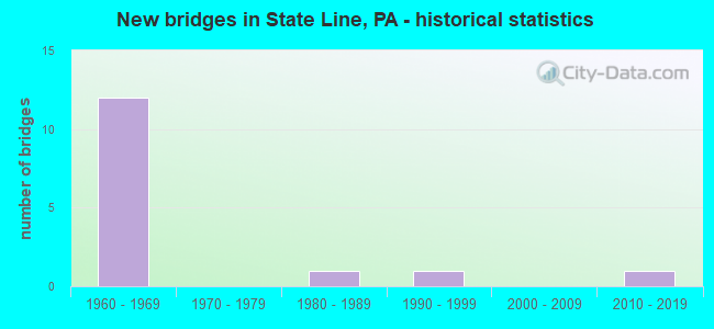
- New bridges - historical statistics
- 121960-1969
- 11980-1989
- 11990-1999
- 12010-2019

- Reconstructed bridges - Historical Statistics
- 11970-1979
- 01980-1989
- 01990-1999
- 22000-2009


- Bridge Condition - Deck
- 16.7%Very good
- 66.7%Good
- 16.7%Satisfactory

- Bridge Condition - Superstructure
- 16.7%Very good
- 16.7%Good
- 33.3%Satisfactory
- 33.3%Fair

- Bridge Condition - Substructure
- 33.3%Good
- 16.7%Satisfactory
- 50.0%Fair
Find on map >> Show street view
Structure Number: 17279, Location: 1.5 MI.S. OF GREENCASTLE (Lat: 39.755981, Lng: -77.726950), Route carried "on" structure: US 11, Year Built: 1960, Year Reconstructed: 2014, Status: Open, Structure Length: 8.35m (27.40ft), Average Daily Traffic: 12,357 (year 2022), Truck Traffic: 13%, Average Future Daily Traffic: 17,634 (year 2035), Design Load: HL 93, Features Intersected: I-81; SR 0081
Minimum Vertical Clearance: 30+ m (98+ ft), Kilometerpoint: 3.560, Lanes on structure: 2, Lanes under structure: 8, Owner: State Highway Agency, Approaching Roadway Width: 9.8m (32.2ft), Skew: 6 degrees, Material/Design: Steel continuous, Design/Construction: Stringer/Multi-beam, Number Of Spans In Main Unit: 2, Length of Maximum Span: 40.2m (131.9ft), Curb or Sidewalk Widths: Left: 0.2m (0.7ft), Right: 0.2m (0.7ft), Curb-To-Curb Width: 10.3m (33.8ft), Out-to-Out Width: 11.3m (37.1ft)
Condition: Deck: Good, Superstructure: Satisfactory, Substructure: Fair, Operating Rating: 81.6 metric tons, Method Used To Determine Operating Rating: Load and Resistance Factor (LRFR), Inventory Rating: 62.6 metric tons, Method Used To Determine Inventory Rating: Load and Resistance Factor (LRFR), Structural Evaluation: Somewhat better than minimum adequacy, Deck Geometry: Meets minimum limits, Underclear: Somewhat better than minimum adequacy, Approach Roadway Alignment: Equal to present desirable criteria, Length Of Structure Improvement: 9.40m (30.84ft), Designated Inspection Frequency: Every 24 months, Inspection Date: December 2019, Bridge Improvement Cost: $124,000, Roadway Improvement Cost: $365,000, Total Project Cost: $1,672,000, Deck Structure Type: Concrete Cast-file-Place, Wearing Surface/Protective System: Wearing Surface: Monolithic Concrete, Deck Protection: Epoxy Coated Reinforcing
Find on map >> Show street view
Structure Number: 17359, Location: 0.75 N. OF STATE LINE (Lat: 39.731728, Lng: -77.726639), Route carried "on" structure: State highway , Year Built: 1960, Status: Open, Structure Length: 6.61m (21.69ft), Average Daily Traffic: 2,707 (year 2022), Truck Traffic: 8%, Average Future Daily Traffic: 3,247 (year 2032), Design Load: HS 20, Features Intersected: I-81; SR 0081, Facility Carried by Structure: T-351 (HYKES RD)
Minimum Vertical Clearance: 30+ m (98+ ft), Kilometerpoint: 0.000, Lanes on structure: 2, Lanes under structure: 8, Owner: State Highway Agency, Approaching Roadway Width: 9.1m (29.9ft), Skew: 2 degrees, Material/Design: Prestressed concrete, Design/Construction: Stringer/Multi-beam, Number Of Spans In Main Unit: 4, Length of Maximum Span: 20.7m (67.9ft), Curb or Sidewalk Widths: Left: 0.5m (1.6ft), Right: 0.5m (1.6ft), Curb-To-Curb Width: 8.5m (27.9ft), Out-to-Out Width: 10.3m (33.8ft)
Condition: Deck: Satisfactory, Superstructure: Satisfactory, Substructure: Fair, Operating Rating: 80.7 metric tons, Method Used To Determine Operating Rating: Load Factor (LF), Inventory Rating: 34.5 metric tons, Method Used To Determine Inventory Rating: Load Factor (LF), Structural Evaluation: Somewhat better than minimum adequacy, Deck Geometry: Meets minimum limits, Underclear: Somewhat better than minimum adequacy, Approach Roadway Alignment: Equal to present desirable criteria, Length Of Structure Improvement: 7.60m (24.93ft), Designated Inspection Frequency: Every 24 months, Inspection Date: January 2020, Bridge Improvement Cost: $72,000, Roadway Improvement Cost: $212,000, Total Project Cost: $973,000, Deck Structure Type: Concrete Cast-file-Place, Wearing Surface/Protective System: Wearing Surface: Bituminous
Find on map >> Show street view
Structure Number: 174, Location: Mason Dixon Line (Lat: 39.721242, Lng: -77.732500), Route carried "on" structure: State highway 163, Year Built: 1960, Year Reconstructed: 1983, Status: Open, Structure Length: 9.45m (31.00ft), Average Daily Traffic: 2,487 (year 2021), Truck Traffic: 5%, Average Future Daily Traffic: 3,496 (year 2032), Design Load: HS 20, Features Intersected: I-81; SR 0081
Minimum Vertical Clearance: 30+ m (98+ ft), Kilometerpoint: 3.072, Lanes on structure: 2, Lanes under structure: 4, Base Highway Network: Yes, Owner: State Highway Agency, Approaching Roadway Width: 9.8m (32.2ft), Skew: 4 degrees, Material/Design: Steel continuous, Design/Construction: Stringer/Multi-beam, Number Of Spans In Main Unit: 2, Number Of Approach Spans: 2, Length of Maximum Span: 31.4m (103.0ft), Curb or Sidewalk Widths: Left: 0.2m (0.7ft), Right: 0.2m (0.7ft), Curb-To-Curb Width: 10.4m (34.1ft), Out-to-Out Width: 11.5m (37.7ft)
Condition: Deck: Good, Superstructure: Fair, Substructure: Fair, Operating Rating: 59.0 metric tons, Method Used To Determine Operating Rating: Load Factor (LF), Inventory Rating: 35.4 metric tons, Method Used To Determine Inventory Rating: Load Factor (LF), Structural Evaluation: Somewhat better than minimum adequacy, Deck Geometry: Somewhat better than minimum adequacy, Underclear: Somewhat better than minimum adequacy, Approach Roadway Alignment: Equal to present desirable criteria, Length Of Structure Improvement: 10.40m (34.12ft), Designated Inspection Frequency: Every 24 months, Inspection Date: Febuary 2020, Bridge Improvement Cost: $19,000, Roadway Improvement Cost: $57,000, Total Project Cost: $260,000, Deck Structure Type: Concrete Cast-file-Place, Wearing Surface/Protective System: Wearing Surface: Latex Concrete, Deck Protection: Epoxy Coated Reinforcing
Find on map >> Show street view
Structure Number: 17543, Location: 0.5 Mi. NW of Milnor (Lat: 39.758083, Lng: -77.753542), Route carried "on" structure: State highway , Year Built: 1982, Status: Open, Structure Length: 0.73m (2.40ft), Average Daily Traffic: 135 (year 2019), Truck Traffic: 18%, Average Future Daily Traffic: 914 (year 2032), Design Load: HS 20, Features Intersected: Trib Conococheague Creek, Facility Carried by Structure: SR 3006;Milnor Rd.
Minimum Vertical Clearance: 30+ m (98+ ft), Kilometerpoint: 0.000, Lanes on structure: 2, Owner: State Highway Agency, Approaching Roadway Width: 7.9m (25.9ft), Skew: 4 degrees, Material/Design: Concrete, Design/Construction: Frame, Number Of Spans In Main Unit: 1, Length of Maximum Span: 6.4m (21.0ft), Curb-To-Curb Width: 8.5m (27.9ft), Out-to-Out Width: 9.6m (31.5ft)
Condition: Deck: Good, Superstructure: Good, Substructure: Good, Channel: Good, Operating Rating: 88.0 metric tons, Method Used To Determine Operating Rating: Load Factor (LF), Inventory Rating: 52.6 metric tons, Method Used To Determine Inventory Rating: Load Factor (LF), Structural Evaluation: Better than present minimum criteria, Deck Geometry: Equal to present minimum criteria, Waterway Adequacy: Equal to present minimum criteria, Approach Roadway Alignment: Equal to present desirable criteria, Length Of Structure Improvement: 1.40m (4.59ft), Designated Inspection Frequency: Every 24 months, Inspection Date: March 2020, Bridge Improvement Cost: $3,000, Roadway Improvement Cost: $9,000, Total Project Cost: $43,000, Wearing Surface/Protective System: Wearing Surface: Monolithic Concrete, Deck Protection: Epoxy Coated Reinforcing
Find on map >> Show street view
Structure Number: 17544, Location: 1.75 ML. N. OF STATE LINE (Lat: 39.746322, Lng: -77.728356), Route carried "on" structure: State highway , Year Built: 1960, Year Reconstructed: 2008, Status: Open, Structure Length: 7.10m (23.29ft), Average Daily Traffic: 74 (year 2019), Truck Traffic: 16%, Average Future Daily Traffic: 914 (year 2032), Design Load: HS 20, Features Intersected: I-81; SR 0081, Facility Carried by Structure: SR 3006
Minimum Vertical Clearance: 30+ m (98+ ft), Kilometerpoint: 1.915, Lanes on structure: 2, Lanes under structure: 8, Owner: State Highway Agency, Approaching Roadway Width: 7.9m (25.9ft), Skew: 3 degrees, Material/Design: Prestressed concrete, Design/Construction: Stringer/Multi-beam, Number Of Spans In Main Unit: 4, Length of Maximum Span: 23.2m (76.1ft), Curb-To-Curb Width: 8.5m (27.9ft), Out-to-Out Width: 10.2m (33.5ft)
Condition: Deck: Good, Superstructure: Fair, Substructure: Satisfactory, Operating Rating: 80.7 metric tons, Method Used To Determine Operating Rating: Load Factor (LF), Inventory Rating: 30.8 metric tons, Method Used To Determine Inventory Rating: Load Factor (LF), Structural Evaluation: Somewhat better than minimum adequacy, Deck Geometry: Better than present minimum criteria, Underclear: Equal to present minimum criteria, Approach Roadway Alignment: Better than present minimum criteria, Length Of Structure Improvement: 8.00m (26.25ft), Designated Inspection Frequency: Every 24 months, Inspection Date: January 2020, Bridge Improvement Cost: $95,000, Roadway Improvement Cost: $279,000, Total Project Cost: $1,278,000, Deck Structure Type: Concrete Cast-file-Place, Wearing Surface/Protective System: Wearing Surface: Monolithic Concrete, Deck Protection: Epoxy Coated Reinforcing
Find on map >> Show street view
Structure Number: 48605, Location: 1.5 M west of US 11 (Lat: 39.741497, Lng: -77.749069), Route carried "on" structure: City street , Year Built: 2012, Status: Open, Structure Length: 4.05m (13.29ft), Average Daily Traffic: 500 (year 2020), Truck Traffic: 2%, Average Future Daily Traffic: 750 (year 2040), Design Load: HL 93, Features Intersected: Norfolk Southern RR, Facility Carried by Structure: Hykes Road
Minimum Vertical Clearance: 30+ m (98+ ft), Kilometerpoint: 0.000, Lanes on structure: 2, Owner: Town or Township Highway Agency, Maintenance Responsibility: Railroad, Approaching Roadway Width: 9.1m (29.9ft), Skew: 3 degrees, Material/Design: Prestressed concrete, Design/Construction: Stringer/Multi-beam, Number Of Spans In Main Unit: 1, Length of Maximum Span: 39.0m (128.0ft), Curb or Sidewalk Widths: Left: 0.2m (0.7ft), Right: 0.2m (0.7ft), Curb-To-Curb Width: 9.1m (29.9ft), Out-to-Out Width: 10.2m (33.5ft)
Condition: Deck: Very good, Superstructure: Very good, Substructure: Good, Operating Rating: 62.2 metric tons, Method Used To Determine Operating Rating: Assigned ratings based on Load and Resistance Factor Design (LRFD) reported by rating factor (RF) using HL93 loadings, Inventory Rating: 32.7 metric tons, Method Used To Determine Inventory Rating: Assigned ratings based on Load and Resistance Factor Design (LRFD) reported by rating factor (RF) using HL93 loadings, Structural Evaluation: Better than present minimum criteria, Deck Geometry: Equal to present minimum criteria, Underclear: High priority of corrective action, Approach Roadway Alignment: Somewhat better than minimum adequacy, Designated Inspection Frequency: Every 24 months, Inspection Date: May 2020, Deck Structure Type: Concrete Cast-file-Place, Wearing Surface/Protective System: Wearing Surface: Monolithic Concrete, Deck Protection: Epoxy Coated Reinforcing
Find on map >> Show street view
Structure Number: 48747, Location: Norlo Pk, .2 mi S of SR30 (Lat: 39.741597, Lng: -77.749097), Route carried "on" structure: City street , Year Built: 1992, Status: Open, Structure Length: 0.61m (2.00ft), Average Daily Traffic: 1,036 (year 2012), Truck Traffic: 5%, Average Future Daily Traffic: 1,550 (year 2032), Features Intersected: Trib to Conococheague Ck, Facility Carried by Structure: Lincoln Ter
Minimum Vertical Clearance: 30+ m (98+ ft), Kilometerpoint: 0.000, Lanes on structure: 2, Owner: County Highway Agency, Approaching Roadway Width: 6.1m (20.0ft), Material/Design: Concrete, Design/Construction: Culvert, Number Of Spans In Main Unit: 2, Length of Maximum Span: 3.0m (9.8ft), Curb-To-Curb Width: 7.3m (24.0ft), Out-to-Out Width: 8.5m (27.9ft)
Condition: Channel: Good, Culverts: Fair, Operating Rating: 49.0 metric tons, Method Used To Determine Operating Rating: Field evaluation and documented engineering judgment, Inventory Rating: 32.7 metric tons, Method Used To Determine Inventory Rating: Field evaluation and documented engineering judgment, Structural Evaluation: Somewhat better than minimum adequacy, Deck Geometry: Meets minimum limits, Waterway Adequacy: Superior to present desirable criteria, Approach Roadway Alignment: Equal to present desirable criteria, Designated Inspection Frequency: Every 24 months, Inspection Date: August 2020, Wearing Surface/Protective System: Wearing Surface: Bituminous
Find on map >> Show street view
Structure Number: 17279, Location: 1.5 MI.S. OF GREENCASTLE (Lat: 39.755981, Lng: -77.726950), Route carried "under" structure: Interstate 81, Year Built: 1960, Structure Length: 0. m, Average Daily Traffic: 22,617 (year 2021), Truck Traffic: 37%, Features Intersected: I-81; SR 0081, Facility Carried by Structure: US 11; Molly Pitch
Minimum Vertical Clearance: 5.00m (16.40ft), Kilometerpoint: 4.089, Lanes on structure: 2, Lanes under structure: 4, Material/Design: Steel continuous, Design/Construction: Stringer/Multi-beam, Length of Maximum Span: 40.2m (131.9ft)
Find on map >> Show street view
Structure Number: 17279, Location: 1.5 MI.S. OF GREENCASTLE (Lat: 39.755981, Lng: -77.726950), Route carried "under" structure: Interstate 81, Year Built: 1960, Structure Length: 0. m, Average Daily Traffic: 22,927 (year 2021), Truck Traffic: 35%, Features Intersected: I-81; SR 0081, Facility Carried by Structure: US 11; Molly Pitch
Minimum Vertical Clearance: 5.00m (16.40ft), Kilometerpoint: 4.126, Lanes on structure: 2, Lanes under structure: 4, Material/Design: Steel continuous, Design/Construction: Stringer/Multi-beam, Length of Maximum Span: 40.2m (131.9ft)
Find on map >> Show street view
Structure Number: 17359, Location: 0.75 N. OF STATE LINE (Lat: 39.731728, Lng: -77.726639), Route carried "under" structure: Interstate 81, Year Built: 1960, Structure Length: 0. m, Average Daily Traffic: 31,758 (year 2021), Truck Traffic: 17%, Features Intersected: I-81; SR 0081, Facility Carried by Structure: T-351 (HYKES RD)
Minimum Vertical Clearance: 5.00m (16.40ft), Kilometerpoint: 0.810, Lanes on structure: 2, Lanes under structure: 4, Material/Design: Prestressed concrete, Design/Construction: Stringer/Multi-beam, Length of Maximum Span: 20.7m (67.9ft)
Find on map >> Show street view
Structure Number: 17359, Location: 0.75 N. OF STATE LINE (Lat: 39.731728, Lng: -77.726639), Route carried "under" structure: Interstate 81, Year Built: 1960, Structure Length: 0. m, Average Daily Traffic: 32,869 (year 2021), Truck Traffic: 15%, Features Intersected: I-81; SR 0081, Facility Carried by Structure: T-351 (HYKES RD)
Minimum Vertical Clearance: 5.00m (16.40ft), Kilometerpoint: 0.785, Lanes on structure: 2, Lanes under structure: 4, Material/Design: Prestressed concrete, Design/Construction: Stringer/Multi-beam, Length of Maximum Span: 20.7m (67.9ft)
Find on map >> Show street view
Structure Number: 174, Location: Mason Dixon Line (Lat: 39.721242, Lng: -77.732500), Route carried "under" structure: Interstate 81, Year Built: 1960, Structure Length: 0. m, Average Daily Traffic: 31,758 (year 2021), Truck Traffic: 17%, Features Intersected: I-81; SR 0081, Facility Carried by Structure: PA 163;Mason Dixon
Minimum Vertical Clearance: 5.05m (16.57ft), Kilometerpoint: 0.000, Lanes on structure: 2, Lanes under structure: 4, Material/Design: Steel continuous, Design/Construction: Stringer/Multi-beam, Length of Maximum Span: 31.4m (103.0ft)
Find on map >> Show street view
Structure Number: 174, Location: Mason Dixon Line (Lat: 39.721242, Lng: -77.732500), Route carried "under" structure: Interstate 81, Year Built: 1960, Structure Length: 0. m, Average Daily Traffic: 32,869 (year 2021), Truck Traffic: 15%, Features Intersected: I-81; SR 0081, Facility Carried by Structure: PA 163;Mason Dixon
Minimum Vertical Clearance: 5.05m (16.57ft), Kilometerpoint: 0.000, Lanes on structure: 2, Lanes under structure: 4, Material/Design: Steel continuous, Design/Construction: Stringer/Multi-beam, Length of Maximum Span: 31.4m (103.0ft)
Find on map >> Show street view
Structure Number: 17544, Location: 1.75 ML. N. OF STATE LINE (Lat: 39.746322, Lng: -77.728356), Route carried "under" structure: Interstate 81, Year Built: 1960, Structure Length: 0. m, Average Daily Traffic: 31,758 (year 2021), Truck Traffic: 17%, Features Intersected: I-81; SR 0081, Facility Carried by Structure: SR 3006
Minimum Vertical Clearance: 5.13m (16.83ft), Kilometerpoint: 2.432, Lanes on structure: 2, Lanes under structure: 4, Material/Design: Prestressed concrete, Design/Construction: Stringer/Multi-beam, Length of Maximum Span: 23.2m (76.1ft)
Find on map >> Show street view
Structure Number: 17544, Location: 1.75 ML. N. OF STATE LINE (Lat: 39.746322, Lng: -77.728356), Route carried "under" structure: Interstate 81, Year Built: 1960, Structure Length: 0. m, Average Daily Traffic: 32,869 (year 2021), Truck Traffic: 15%, Features Intersected: I-81; SR 0081, Facility Carried by Structure: SR 3006
Minimum Vertical Clearance: 5.11m (16.77ft), Kilometerpoint: 2.382, Lanes on structure: 2, Lanes under structure: 4, Material/Design: Prestressed concrete, Design/Construction: Stringer/Multi-beam, Length of Maximum Span: 23.2m (76.1ft)