Bridge Statistics for State Line, Mississippi (MS)
Condition, Traffic, Stress, Structural Evaluation, Project Costs
- National Bridge Inventory (NBI) Statistics
- 21Number of bridges
- 335ft / 102mTotal length
- $1,419,000Total costs
- 16,880Total average daily traffic
- 2,606Total average daily truck traffic
- National Bridge Inventory (NBI) Registered Bridges for State Line
- No street view available for this location
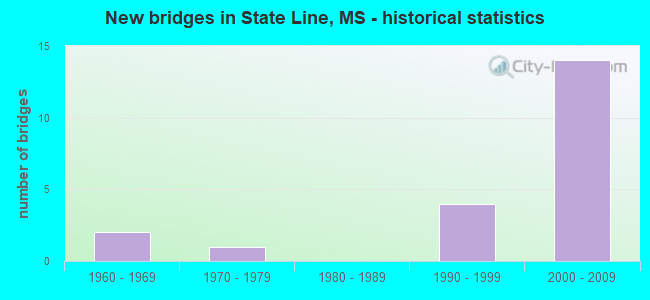
- New bridges - historical statistics
- 21960-1969
- 11970-1979
- 41990-1999
- 142000-2009


- Bridge Condition - Deck
- 30.8%Very good
- 46.2%Good
- 23.1%Satisfactory

- Bridge Condition - Superstructure
- 46.2%Very good
- 7.7%Good
- 38.5%Satisfactory
- 7.7%Fair

- Bridge Condition - Substructure
- 53.8%Very good
- 7.7%Good
- 23.1%Satisfactory
- 15.4%Fair

- Bridge Condition - Channel
- 18.2%Very good
- 27.3%Good
- 45.5%Satisfactory
- 9.1%Poor

- Bridge Condition - Culverts
- 50.0%Good
- 50.0%Satisfactory
Find on map >> Show street view
Structure Number: 21000450770031A, Location: 3.1 MI N ALA STATE LINE (Lat: 31.470989, Lng: -88.477144), Route carried "on" structure: US 45, Year Built: 2006, Status: Open, Structure Length: 3.90m (12.80ft), Average Daily Traffic: 2,650 (year 2020), Truck Traffic: 22%, Average Future Daily Traffic: 2,800 (year 2040), Design Load: HS 20, Features Intersected: SAVANNAH BRANCH
Minimum Vertical Clearance: 30+ m (98+ ft), Kilometerpoint: 48.050, Lanes on structure: 2, Base Highway Network: Yes (Inventory Route: 4, Subroute: 1), Owner: State Highway Agency, Approaching Roadway Width: 12.0m (39.4ft), Skew: 10 degrees, Material/Design: Prestressed concrete continuous, Design/Construction: Stringer/Multi-beam, Number Of Spans In Main Unit: 3, Length of Maximum Span: 13.0m (42.7ft), Curb-To-Curb Width: 12.0m (39.4ft), Out-to-Out Width: 12.9m (42.3ft)
Condition: Deck: Good, Superstructure: Very good, Substructure: Very good, Channel: Very good, Operating Rating: 59.3 metric tons, Method Used To Determine Operating Rating: Load Factor (LF), Inventory Rating: 35.5 metric tons, Method Used To Determine Inventory Rating: Load Factor (LF), Structural Evaluation: Equal to present desirable criteria, Deck Geometry: Better than present minimum criteria, Waterway Adequacy: Equal to present desirable criteria, Approach Roadway Alignment: Equal to present desirable criteria, Designated Inspection Frequency: Every 24 months, Inspection Date: September 2021, Deck Structure Type: Concrete Cast-file-Place
Find on map >> Show street view
Structure Number: 21000450770031B, Location: 3.1 MI N ALA STATE LINE (Lat: 31.470872, Lng: -88.476586), Route carried "on" structure: US 45, Year Built: 2003, Status: Open, Structure Length: 3.90m (12.80ft), Average Daily Traffic: 2,650 (year 2020), Truck Traffic: 22%, Average Future Daily Traffic: 2,800 (year 2040), Design Load: HS 20, Features Intersected: SAVANNAH BRANCH
Minimum Vertical Clearance: 30+ m (98+ ft), Kilometerpoint: 4.572, Lanes on structure: 2, Base Highway Network: Yes (Inventory Route: 4, Subroute: 1), Owner: State Highway Agency, Approaching Roadway Width: 12.0m (39.4ft), Skew: 10 degrees, Material/Design: Prestressed concrete continuous, Design/Construction: Stringer/Multi-beam, Number Of Spans In Main Unit: 3, Length of Maximum Span: 13.0m (42.7ft), Curb-To-Curb Width: 12.0m (39.4ft), Out-to-Out Width: 12.9m (42.3ft)
Condition: Deck: Very good, Superstructure: Very good, Substructure: Very good, Channel: Good, Operating Rating: 59.3 metric tons, Method Used To Determine Operating Rating: Load Factor (LF), Inventory Rating: 35.5 metric tons, Method Used To Determine Inventory Rating: Load Factor (LF), Structural Evaluation: Equal to present desirable criteria, Deck Geometry: Better than present minimum criteria, Waterway Adequacy: Equal to present desirable criteria, Approach Roadway Alignment: Equal to present desirable criteria, Designated Inspection Frequency: Every 24 months, Inspection Date: September 2021, Deck Structure Type: Concrete Cast-file-Place
Find on map >> Show street view
Structure Number: 31000420211079, Location: 4.4 MI W SR 57 (Lat: 31.422936, Lng: -88.542053), Route carried "on" structure: State highway 42, Year Built: 1968, Status: Open, Structure Length: 12.83m (42.09ft), Average Daily Traffic: 620 (year 2020), Truck Traffic: 31%, Average Future Daily Traffic: 620 (year 2040), Design Load: HS 20, Features Intersected: CHICKASAWHAY RIVER
Minimum Vertical Clearance: 30+ m (98+ ft), Kilometerpoint: 32.169, Lanes on structure: 2, Base Highway Network: Yes (Inventory Route: 4, Subroute: 1), Owner: State Highway Agency, Approaching Roadway Width: 9.8m (32.2ft), Material/Design: Steel continuous, Design/Construction: Stringer/Multi-beam, Number Of Spans In Main Unit: 3, Number Of Approach Spans: 3, Length of Maximum Span: 36.6m (120.1ft), Curb-To-Curb Width: 8.5m (27.9ft), Out-to-Out Width: 10.0m (32.8ft)
Condition: Deck: Good, Superstructure: Satisfactory, Substructure: Satisfactory, Channel: Poor, Operating Rating: 55.8 metric tons, Method Used To Determine Operating Rating: Load Factor (LF), Inventory Rating: 33.4 metric tons, Method Used To Determine Inventory Rating: Load Factor (LF), Structural Evaluation: Equal to present minimum criteria, Deck Geometry: Somewhat better than minimum adequacy, Waterway Adequacy: Superior to present desirable criteria, Approach Roadway Alignment: Equal to present desirable criteria, Designated Inspection Frequency: Every 24 months, Underwater Inspection Frequency: Every 60 months, Inspection Date: April 2020, Underwater Inspection Date: June 2019, Deck Structure Type: Concrete Cast-file-Place
Find on map >> Show street view
Structure Number: 3100042077113, Location: SR 42 OVER SR 57 (Lat: 31.436144, Lng: -88.466086), Route carried "on" structure: State highway 42, Year Built: 2007, Status: Open, Structure Length: 10.00m (32.81ft), Average Daily Traffic: 1,000 (year 2020), Truck Traffic: 14%, Average Future Daily Traffic: 1,300 (year 2040), Design Load: HS 20, Features Intersected: SR 57
Minimum Vertical Clearance: 30+ m (98+ ft), Kilometerpoint: 0.393, Lanes on structure: 2, Lanes under structure: 4, Base Highway Network: Yes (Inventory Route: 4, Subroute: 1), Owner: State Highway Agency, Approaching Roadway Width: 15.6m (51.2ft), Material/Design: Prestressed concrete continuous, Design/Construction: Stringer/Multi-beam, Number Of Spans In Main Unit: 4, Length of Maximum Span: 30.0m (98.4ft), Curb-To-Curb Width: 15.6m (51.2ft), Out-to-Out Width: 17.9m (58.7ft)
Condition: Deck: Good, Superstructure: Very good, Substructure: Very good, Operating Rating: 67.1 metric tons, Method Used To Determine Operating Rating: Load Factor (LF), Inventory Rating: 30.5 metric tons, Method Used To Determine Inventory Rating: Load Factor (LF), Structural Evaluation: Better than present minimum criteria, Deck Geometry: Superior to present desirable criteria, Underclear: Superior to present desirable criteria, Approach Roadway Alignment: Equal to present desirable criteria, Designated Inspection Frequency: Every 24 months, Inspection Date: September 2021, Deck Structure Type: Concrete Cast-file-Place
Find on map >> Show street view
Structure Number: 31000570770943A, Location: SR 57 OVER SR 142 (Lat: 31.445533, Lng: -88.465219), Route carried "on" structure: State highway 57, Year Built: 2007, Status: Open, Structure Length: 7.89m (25.89ft), Average Daily Traffic: 550 (year 2020), Truck Traffic: 19%, Average Future Daily Traffic: 600 (year 2040), Design Load: HS 20, Features Intersected: SR 142
Minimum Vertical Clearance: 30+ m (98+ ft), Kilometerpoint: 0.394, Lanes on structure: 2, Lanes under structure: 2, Base Highway Network: Yes (Inventory Route: 5, Subroute: 1), Owner: State Highway Agency, Approaching Roadway Width: 12.6m (41.3ft), Skew: 13 degrees, Material/Design: Prestressed concrete continuous, Design/Construction: Stringer/Multi-beam, Number Of Spans In Main Unit: 3, Length of Maximum Span: 34.0m (111.5ft), Curb-To-Curb Width: 12.6m (41.3ft), Out-to-Out Width: 13.5m (44.3ft)
Condition: Deck: Very good, Superstructure: Very good, Substructure: Very good, Operating Rating: 70.6 metric tons, Method Used To Determine Operating Rating: Load Factor (LF), Inventory Rating: 40.7 metric tons, Method Used To Determine Inventory Rating: Load Factor (LF), Structural Evaluation: Equal to present desirable criteria, Deck Geometry: Better than present minimum criteria, Underclear: Superior to present desirable criteria, Approach Roadway Alignment: Equal to present desirable criteria, Designated Inspection Frequency: Every 24 months, Inspection Date: September 2021, Deck Structure Type: Concrete Cast-file-Place
Find on map >> Show street view
Structure Number: 31000570770943B, Location: SR 57 OVER SR 142 (Lat: 31.444989, Lng: -88.464958), Route carried "on" structure: State highway 57, Year Built: 2007, Status: Open, Structure Length: 7.89m (25.89ft), Average Daily Traffic: 550 (year 2020), Truck Traffic: 19%, Average Future Daily Traffic: 600 (year 2040), Design Load: HS 20, Features Intersected: SR 142
Minimum Vertical Clearance: 30+ m (98+ ft), Kilometerpoint: 1.015, Lanes on structure: 2, Lanes under structure: 2, Base Highway Network: Yes (Inventory Route: 5, Subroute: 1), Owner: State Highway Agency, Approaching Roadway Width: 12.6m (41.3ft), Skew: 13 degrees, Material/Design: Prestressed concrete continuous, Design/Construction: Stringer/Multi-beam, Number Of Spans In Main Unit: 3, Length of Maximum Span: 34.0m (111.5ft), Curb-To-Curb Width: 12.6m (41.3ft), Out-to-Out Width: 13.5m (44.3ft)
Condition: Deck: Very good, Superstructure: Very good, Substructure: Very good, Operating Rating: 70.6 metric tons, Method Used To Determine Operating Rating: Load Factor (LF), Inventory Rating: 40.7 metric tons, Method Used To Determine Inventory Rating: Load Factor (LF), Structural Evaluation: Equal to present desirable criteria, Deck Geometry: Better than present minimum criteria, Underclear: Superior to present desirable criteria, Approach Roadway Alignment: Equal to present desirable criteria, Designated Inspection Frequency: Every 24 months, Inspection Date: September 2021, Deck Structure Type: Concrete Cast-file-Place
Find on map >> Show street view
Structure Number: 3100057077095, Location: SR 57 OVER US 45 (Lat: 31.451650, Lng: -88.464614), Route carried "on" structure: State highway 57, Year Built: 2007, Status: Open, Structure Length: 38.12m (125.07ft), Average Daily Traffic: 760 (year 2020), Truck Traffic: 18%, Average Future Daily Traffic: 800 (year 2040), Design Load: HS 20, Features Intersected: US 45
Minimum Vertical Clearance: 30+ m (98+ ft), Kilometerpoint: 0.285, Lanes on structure: 2, Lanes under structure: 4, Owner: State Highway Agency, Approaching Roadway Width: 12.6m (41.3ft), Material/Design: Steel continuous, Design/Construction: Stringer/Multi-beam, Number Of Spans In Main Unit: 7, Length of Maximum Span: 65.0m (213.3ft), Curb-To-Curb Width: 12.6m (41.3ft), Out-to-Out Width: 13.5m (44.3ft)
Condition: Deck: Very good, Superstructure: Very good, Substructure: Very good, Operating Rating: 72.0 metric tons, Method Used To Determine Operating Rating: Load Factor (LF), Inventory Rating: 43.1 metric tons, Method Used To Determine Inventory Rating: Load Factor (LF), Structural Evaluation: Equal to present desirable criteria, Deck Geometry: Better than present minimum criteria, Underclear: Superior to present desirable criteria, Approach Roadway Alignment: Equal to present desirable criteria, Designated Inspection Frequency: Every 24 months, Inspection Date: September 2021, Deck Structure Type: Concrete Cast-file-Place
Find on map >> Show street view
Structure Number: SA2100000000083, Location: SEC 6 T 5N R 5W (Lat: 31.424592, Lng: -88.525908), Route carried "on" structure: County highway 116, Year Built: 1995, Status: Open, Structure Length: 2.90m (9.51ft), Average Daily Traffic: 100 (year 2021), Truck Traffic: 2%, Average Future Daily Traffic: 150 (year 2041), Design Load: HS 15, Features Intersected: DAVIS CREEK, Facility Carried by Structure: BATTLE ROAD
Minimum Vertical Clearance: 30+ m (98+ ft), Kilometerpoint: 33.957, Lanes on structure: 2, Owner: County Highway Agency, Approaching Roadway Width: 8.1m (26.6ft), Material/Design: Concrete, Design/Construction: Channel Beam, Number Of Spans In Main Unit: 5, Length of Maximum Span: 5.8m (19.0ft), Curb or Sidewalk Widths: Left: 0.2m (0.7ft), Right: 0.2m (0.7ft), Curb-To-Curb Width: 8.1m (26.6ft), Out-to-Out Width: 8.5m (27.9ft)
Condition: Deck: Satisfactory, Superstructure: Fair, Substructure: Fair, Channel: Satisfactory, Operating Rating: 48.1 metric tons, Method Used To Determine Operating Rating: Load Factor (LF), Inventory Rating: 28.8 metric tons, Method Used To Determine Inventory Rating: Load Factor (LF), Structural Evaluation: Somewhat better than minimum adequacy, Deck Geometry: Equal to present minimum criteria, Waterway Adequacy: Equal to present desirable criteria, Approach Roadway Alignment: Equal to present minimum criteria, Length Of Structure Improvement: 18.29m (60.01ft), Designated Inspection Frequency: Every 24 months, Inspection Date: October 2021, Bridge Improvement Cost: $325,000, Roadway Improvement Cost: $125,000, Total Project Cost: $450,000 ( Estimate for 2021), Deck Structure Type: Concrete Precast Panels
Find on map >> Show street view
Structure Number: SA2100000000084, Location: SEC 18 T 5N R 5W B (Lat: 31.393178, Lng: -88.534736), Route carried "on" structure: County highway 39, Year Built: 2004, Status: Open, Structure Length: 3.04m (9.97ft), Average Daily Traffic: 120 (year 2021), Truck Traffic: 10%, Average Future Daily Traffic: 160 (year 2041), Design Load: HS 20, Features Intersected: SNELL CREEK, Facility Carried by Structure: KNOBTOWN ROAD
Minimum Vertical Clearance: 30+ m (98+ ft), Kilometerpoint: 4.988, Lanes on structure: 2, Owner: County Highway Agency, Approaching Roadway Width: 9.1m (29.9ft), Material/Design: Concrete, Design/Construction: Channel Beam, Number Of Spans In Main Unit: 4, Length of Maximum Span: 9.4m (30.8ft), Curb or Sidewalk Widths: Left: 0.4m (1.3ft), Right: 0.4m (1.3ft), Curb-To-Curb Width: 8.5m (27.9ft), Out-to-Out Width: 9.3m (30.5ft)
Condition: Deck: Good, Superstructure: Good, Substructure: Good, Channel: Good, Operating Rating: 63.1 metric tons, Method Used To Determine Operating Rating: Load Factor (LF), Inventory Rating: 37.9 metric tons, Method Used To Determine Inventory Rating: Load Factor (LF), Structural Evaluation: Better than present minimum criteria, Deck Geometry: Equal to present minimum criteria, Waterway Adequacy: Equal to present desirable criteria, Approach Roadway Alignment: Equal to present desirable criteria, Designated Inspection Frequency: Every 24 months, Inspection Date: October 2021, Deck Structure Type: Concrete Precast Panels
Find on map >> Show street view
Structure Number: SA2100000000085, Location: SEC 19 T 5N R 5W B (Lat: 31.379167, Lng: -88.522844), Route carried "on" structure: County highway 298, Year Built: 1961, Status: Open, Structure Length: 2.90m (9.51ft), Average Daily Traffic: 350 (year 2021), Truck Traffic: 20%, Average Future Daily Traffic: 525 (year 2041), Design Load: H 15, Features Intersected: JOHNSON CREEK, Facility Carried by Structure: OLD AVERA RD
Minimum Vertical Clearance: 30+ m (98+ ft), Kilometerpoint: 27.358, Lanes on structure: 2, Owner: County Highway Agency, Approaching Roadway Width: 6.1m (20.0ft), Material/Design: Concrete, Design/Construction: Channel Beam, Number Of Spans In Main Unit: 5, Length of Maximum Span: 5.8m (19.0ft), Curb or Sidewalk Widths: Left: 0.2m (0.7ft), Right: 0.2m (0.7ft), Curb-To-Curb Width: 7.1m (23.3ft), Out-to-Out Width: 7.5m (24.6ft)
Condition: Deck: Satisfactory, Superstructure: Satisfactory, Substructure: Fair, Channel: Good, Operating Rating: 38.2 metric tons, Method Used To Determine Operating Rating: Allowable Stress (AS), Inventory Rating: 22.9 metric tons, Method Used To Determine Inventory Rating: Allowable Stress (AS), Structural Evaluation: Somewhat better than minimum adequacy, Deck Geometry: Meets minimum limits, Waterway Adequacy: Equal to present desirable criteria, Approach Roadway Alignment: Meets minimum limits, Length Of Structure Improvement: 4.00m (13.12ft), Designated Inspection Frequency: Every 24 months, Inspection Date: September 2021, Bridge Improvement Cost: $350,000, Roadway Improvement Cost: $120,000, Total Project Cost: $470,000 ( Estimate for 2021), Deck Structure Type: Concrete Precast Panels, Wearing Surface/Protective System: Wearing Surface: Bituminous
Find on map >> Show street view
Structure Number: SA7700000000003, Location: SEC 21 T 6N R 5W (Lat: 31.468333, Lng: -88.483611), Route carried "on" structure: County highway 57, Year Built: 1991, Status: Open, Structure Length: 1.83m (6.00ft), Average Daily Traffic: 85 (year 2020), Average Future Daily Traffic: 125 (year 2040), Design Load: HS 15, Features Intersected: MONGUS CREEK, Facility Carried by Structure: ERET RD
Minimum Vertical Clearance: 30+ m (98+ ft), Kilometerpoint: 4.345, Lanes on structure: 2, Owner: County Highway Agency, Approaching Roadway Width: 6.7m (22.0ft), Material/Design: Steel, Design/Construction: Stringer/Multi-beam, Number Of Spans In Main Unit: 1, Length of Maximum Span: 18.3m (60.0ft), Curb or Sidewalk Widths: Left: 0.3m (1.0ft), Right: 0.3m (1.0ft), Curb-To-Curb Width: 6.7m (22.0ft), Out-to-Out Width: 7.3m (24.0ft)
Condition: Deck: Good, Superstructure: Satisfactory, Substructure: Satisfactory, Channel: Very good, Operating Rating: 32.4 metric tons, Method Used To Determine Operating Rating: Allowable Stress (AS), Inventory Rating: 24.3 metric tons, Method Used To Determine Inventory Rating: Allowable Stress (AS), Structural Evaluation: Equal to present minimum criteria, Deck Geometry: Somewhat better than minimum adequacy, Waterway Adequacy: Equal to present desirable criteria, Approach Roadway Alignment: Equal to present minimum criteria, Designated Inspection Frequency: Every 24 months, Inspection Date: December 2020, Deck Structure Type: Concrete Cast-file-Place, Wearing Surface/Protective System: Wearing Surface: Bituminous
Find on map >> Show street view
Structure Number: SA7700000000004, Location: SEC 31 T 6N R 5W B (Lat: 31.449017, Lng: -88.525986), Route carried "on" structure: County highway 299, Year Built: 1973, Status: Open, Structure Length: 2.90m (9.51ft), Average Daily Traffic: 350 (year 2020), Truck Traffic: 8%, Average Future Daily Traffic: 525 (year 2040), Design Load: H 15, Features Intersected: BR OF CHICKASAWHAY RIVER, Facility Carried by Structure: WOULARD BEND RI RD
Minimum Vertical Clearance: 30+ m (98+ ft), Kilometerpoint: 5.471, Lanes on structure: 2, Owner: County Highway Agency, Approaching Roadway Width: 6.0m (19.7ft), Material/Design: Concrete, Design/Construction: Channel Beam, Number Of Spans In Main Unit: 5, Length of Maximum Span: 5.8m (19.0ft), Curb or Sidewalk Widths: Left: 0.2m (0.7ft), Right: 0.2m (0.7ft), Curb-To-Curb Width: 7.1m (23.3ft), Out-to-Out Width: 7.6m (24.9ft)
Condition: Deck: Good, Superstructure: Satisfactory, Substructure: Very good, Channel: Satisfactory, Operating Rating: 36.9 metric tons, Method Used To Determine Operating Rating: Allowable Stress (AS), Inventory Rating: 24.2 metric tons, Method Used To Determine Inventory Rating: Allowable Stress (AS), Structural Evaluation: Equal to present minimum criteria, Deck Geometry: Meets minimum limits, Waterway Adequacy: Equal to present minimum criteria, Approach Roadway Alignment: Equal to present desirable criteria, Length Of Structure Improvement: 3.66m (12.01ft), Designated Inspection Frequency: Every 24 months, Inspection Date: January 2021, Bridge Improvement Cost: $218,000, Roadway Improvement Cost: $22,000, Total Project Cost: $269,000 ( Estimate for 2020), Deck Structure Type: Concrete Precast Panels
Find on map >> Show street view
Structure Number: SA7700000000005, Location: SEC 31 T 6N R 5W B (Lat: 31.445839, Lng: -88.527100), Route carried "on" structure: County highway 202, Year Built: 1996, Status: Open, Structure Length: 1.91m (6.27ft), Average Daily Traffic: 75 (year 2020), Average Future Daily Traffic: 112 (year 2040), Design Load: HS 15, Features Intersected: BR OF CHICKASAWHAY RIVER, Facility Carried by Structure: HENDERSON JAMES RD
Minimum Vertical Clearance: 30+ m (98+ ft), Kilometerpoint: 0.965, Lanes on structure: 2, Owner: County Highway Agency, Approaching Roadway Width: 5.8m (19.0ft), Material/Design: Steel, Design/Construction: Stringer/Multi-beam, Number Of Spans In Main Unit: 1, Length of Maximum Span: 16.0m (52.5ft), Curb-To-Curb Width: 7.3m (24.0ft), Out-to-Out Width: 7.8m (25.6ft)
Condition: Deck: Satisfactory, Superstructure: Satisfactory, Substructure: Satisfactory, Channel: Satisfactory, Operating Rating: 37.9 metric tons, Method Used To Determine Operating Rating: Load Factor (LF), Inventory Rating: 22.7 metric tons, Method Used To Determine Inventory Rating: Load Factor (LF), Structural Evaluation: Equal to present minimum criteria, Deck Geometry: Equal to present minimum criteria, Waterway Adequacy: Equal to present desirable criteria, Approach Roadway Alignment: Equal to present desirable criteria, Length Of Structure Improvement: 3.11m (10.20ft), Designated Inspection Frequency: Every 24 months, Inspection Date: January 2021, Bridge Improvement Cost: $185,000, Roadway Improvement Cost: $20,000, Total Project Cost: $230,000 ( Estimate for 2020), Deck Structure Type: Concrete Cast-file-Place, Wearing Surface/Protective System: Wearing Surface: Bituminous
Find on map >> Show street view
Structure Number: SA7700000000006, Location: SEC 33 T 6N R 5W (Lat: 31.436667, Lng: -88.497500), Route carried "on" structure: County highway 246, Year Built: 1996, Status: Open, Structure Length: 0.79m (2.59ft), Average Daily Traffic: 60 (year 2020), Truck Traffic: 20%, Average Future Daily Traffic: 90 (year 2040), Design Load: HS 20, Features Intersected: BR OF CHICKASAWHAY RIVER, Facility Carried by Structure: WEST STATELINE RD
Minimum Vertical Clearance: 30+ m (98+ ft), Kilometerpoint: 1.126, Lanes on structure: 2, Owner: County Highway Agency, Approaching Roadway Width: 6.7m (22.0ft), Material/Design: Concrete, Design/Construction: Culvert, Number Of Spans In Main Unit: 2, Length of Maximum Span: 3.7m (12.1ft)
Condition: Channel: Satisfactory, Culverts: Satisfactory, Operating Rating: 56.9 metric tons, Method Used To Determine Operating Rating: Load Factor (LF), Inventory Rating: 34.7 metric tons, Method Used To Determine Inventory Rating: Load Factor (LF), Structural Evaluation: Equal to present minimum criteria, Waterway Adequacy: Equal to present minimum criteria, Approach Roadway Alignment: Equal to present desirable criteria, Designated Inspection Frequency: Every 24 months, Inspection Date: January 2021
Find on map >> Show street view
Structure Number: SA7700000000156, Location: SEC_19_T 6N_R 5W B (Lat: 31.466044, Lng: -88.521356), Route carried "on" structure: County highway 2001, Year Built: 2000, Status: Open, Structure Length: 0.79m (2.59ft), Average Daily Traffic: 350 (year 2018), Truck Traffic: 8%, Average Future Daily Traffic: 525 (year 2038), Design Load: HS 20, Features Intersected: TRIB TO CHICKASAWHAY RIV, Facility Carried by Structure: FATS SMITH CIRCLE
Minimum Vertical Clearance: 30+ m (98+ ft), Kilometerpoint: 1.609, Lanes on structure: 2, Owner: County Highway Agency, Approaching Roadway Width: 9.1m (29.9ft), Material/Design: Concrete, Design/Construction: Culvert, Number Of Spans In Main Unit: 2, Length of Maximum Span: 3.7m (12.1ft)
Condition: Channel: Satisfactory, Culverts: Good, Operating Rating: 60.8 metric tons, Method Used To Determine Operating Rating: Load Factor (LF), Inventory Rating: 36.3 metric tons, Method Used To Determine Inventory Rating: Load Factor (LF), Structural Evaluation: Better than present minimum criteria, Waterway Adequacy: Equal to present desirable criteria, Approach Roadway Alignment: Equal to present desirable criteria, Designated Inspection Frequency: Every 24 months, Inspection Date: Febuary 2020
Find on map >> Show street view
Structure Number: 3100042077113, Location: SR 42 OVER SR 57 (Lat: 31.436150, Lng: -88.465700), Route carried "under" structure: State highway 57, Year Built: 2007, Structure Length: 0. m, Average Daily Traffic: 450 (year 2018), Truck Traffic: 8%, Features Intersected: SR 57, Facility Carried by Structure: SR 42
Minimum Vertical Clearance: 5.32m (17.45ft), Kilometerpoint: 1.434, Lanes on structure: 2, Lanes under structure: 4, Material/Design: Prestressed concrete continuous, Design/Construction: Stringer/Multi-beam, Length of Maximum Span: 29.9m (98.1ft)
Find on map >> Show street view
Structure Number: 3100042077113, Location: SR 42 OVER SR 57 (Lat: 31.436150, Lng: -88.465419), Route carried "under" structure: State highway 57, Year Built: 2007, Structure Length: 0. m, Average Daily Traffic: 450 (year 2018), Truck Traffic: 8%, Features Intersected: SR 57, Facility Carried by Structure: SR 42
Minimum Vertical Clearance: 5.28m (17.32ft), Kilometerpoint: 0.034, Lanes on structure: 2, Lanes under structure: 4, Material/Design: Prestressed concrete continuous, Design/Construction: Stringer/Multi-beam, Length of Maximum Span: 29.9m (98.1ft)
Find on map >> Show street view
Structure Number: 31000570770943A, Location: SR 57 OVER SR 142 (Lat: 31.445211, Lng: -88.465231), Route carried "under" structure: State highway 142, Year Built: 2007, Structure Length: 0. m, Average Daily Traffic: 530 (year 2018), Truck Traffic: 8%, Features Intersected: SR 142, Facility Carried by Structure: SR 57
Minimum Vertical Clearance: 6.14m (20.14ft), Kilometerpoint: 1.434, Lanes on structure: 2, Lanes under structure: 2, Material/Design: Prestressed concrete continuous, Design/Construction: Stringer/Multi-beam, Length of Maximum Span: 34.1m (111.9ft)
Find on map >> Show street view
Structure Number: 31000570770943B, Location: SR 57 OVER SR 142 (Lat: 31.445381, Lng: -88.464939), Route carried "under" structure: State highway 142, Year Built: 2007, Structure Length: 0. m, Average Daily Traffic: 980 (year 2018), Truck Traffic: 8%, Features Intersected: SR 142, Facility Carried by Structure: SR 57
Minimum Vertical Clearance: 5.32m (17.45ft), Kilometerpoint: 1.468, Lanes on structure: 2, Lanes under structure: 2, Material/Design: Prestressed concrete continuous, Design/Construction: Stringer/Multi-beam, Length of Maximum Span: 34.1m (111.9ft)
Find on map >> Show street view
Structure Number: 3100057077095, Location: SR 57 OVER US 45 (Lat: 31.453739, Lng: -88.464511), Route carried "under" structure: US 45, Year Built: 2007, Structure Length: 0. m, Average Daily Traffic: 2,100 (year 2018), Truck Traffic: 10%, Features Intersected: US 45, Facility Carried by Structure: SR 57
Minimum Vertical Clearance: 5.23m (17.16ft), Kilometerpoint: 50.308, Lanes on structure: 2, Lanes under structure: 4, Material/Design: Steel continuous, Design/Construction: Stringer/Multi-beam, Length of Maximum Span: 64.9m (212.9ft)
Find on map >> Show street view
Structure Number: 3100057077095, Location: SR 57 OVER US 45 (Lat: 31.454339, Lng: -88.464481), Route carried "under" structure: US 45, Year Built: 2007, Structure Length: 0. m, Average Daily Traffic: 2,100 (year 2018), Truck Traffic: 10%, Features Intersected: US 45, Facility Carried by Structure: SR 57
Minimum Vertical Clearance: 5.37m (17.62ft), Kilometerpoint: 2.408, Lanes on structure: 2, Lanes under structure: 4, Material/Design: Steel continuous, Design/Construction: Stringer/Multi-beam, Length of Maximum Span: 64.9m (212.9ft)