Bridge Statistics for Starke, Florida (FL)
Condition, Traffic, Stress, Structural Evaluation, Project Costs
- National Bridge Inventory (NBI) Statistics
- 39Number of bridges
- 394ft / 120mTotal length
- $371,000Total costs
- 190,973Total average daily traffic
- 38,893Total average daily truck traffic
- National Bridge Inventory (NBI) Registered Bridges for Starke
- No street view available for this location
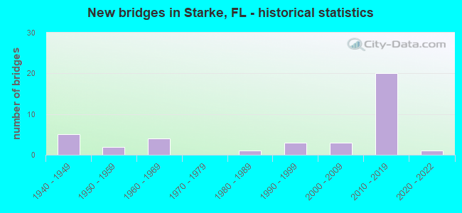
- New bridges - historical statistics
- 51940-1949
- 21950-1959
- 41960-1969
- 11980-1989
- 31990-1999
- 32000-2009
- 202010-2019
- 12020-2022

- Reconstructed bridges - Historical Statistics
- 11950-1959
- 01960-1969
- 01970-1979
- 01980-1989
- 41990-1999


- Bridge Condition - Deck
- 35.0%Excellent
- 10.0%Very good
- 50.0%Good
- 5.0%Satisfactory

- Bridge Condition - Superstructure
- 35.0%Excellent
- 20.0%Very good
- 40.0%Good
- 5.0%Satisfactory

- Bridge Condition - Substructure
- 35.0%Excellent
- 20.0%Very good
- 40.0%Good
- 5.0%Satisfactory

- Bridge Condition - Channel
- 4.3%Excellent
- 8.7%Very good
- 43.5%Good
- 34.8%Satisfactory
- 8.7%Fair

- Bridge Condition - Culverts
- 9.1%Very good
- 36.4%Good
- 45.5%Satisfactory
- 9.1%Fair
Find on map >> Show street view
Structure Number: 280004, Location: 2.4 MI. N. OF SR-16 (Lat: 29.982342, Lng: -82.098539), Route carried "on" structure: US 301, Year Built: 1961, Year Reconstructed: 1999, Status: Open, Structure Length: 1.20m (3.94ft), Average Daily Traffic: 4,800 (year 2020), Truck Traffic: 26%, Average Future Daily Traffic: 8,328 (year 2042), Design Load: HS 20+Mod, Features Intersected: WATER OAK CREEK
Minimum Vertical Clearance: 30+ m (98+ ft), Kilometerpoint: 17.460, Lanes on structure: 5, Base Highway Network: Yes, Owner: State Highway Agency, Approaching Roadway Width: 18.8m (61.7ft), Skew: 13 degrees, Material/Design: Concrete, Design/Construction: Culvert, Number Of Spans In Main Unit: 3, Length of Maximum Span: 3.4m (11.2ft)
Condition: Channel: Satisfactory, Culverts: Satisfactory, Operating Rating: 54.7 metric tons, Method Used To Determine Operating Rating: Load Factor (LF), Inventory Rating: 32.8 metric tons, Method Used To Determine Inventory Rating: Load Factor (LF), Structural Evaluation: Equal to present minimum criteria, Waterway Adequacy: Equal to present desirable criteria, Approach Roadway Alignment: Equal to present desirable criteria, Designated Inspection Frequency: Every 24 months, Inspection Date: May 2020
Find on map >> Show street view
Structure Number: 280005, Location: 3.3 MI. N. OF SR-16 (Lat: 29.994444, Lng: -82.094167), Route carried "on" structure: County highway , Year Built: 1961, Year Reconstructed: 1999, Status: Open, Structure Length: 1.04m (3.41ft), Average Daily Traffic: 21 (year 2020), Truck Traffic: 27%, Average Future Daily Traffic: 36 (year 2042), Design Load: H 15, Features Intersected: WATER OAK CREEK, Facility Carried by Structure: NE 30th Place
Minimum Vertical Clearance: 30+ m (98+ ft), Kilometerpoint: 1.609, Lanes on structure: 2, Owner: County Highway Agency, Approaching Roadway Width: 8.9m (29.2ft), Material/Design: Concrete, Design/Construction: Culvert, Number Of Spans In Main Unit: 3, Length of Maximum Span: 3.4m (11.2ft)
Condition: Channel: Satisfactory, Culverts: Satisfactory, Operating Rating: 55.2 metric tons, Method Used To Determine Operating Rating: Load Factor (LF), Inventory Rating: 33.1 metric tons, Method Used To Determine Inventory Rating: Load Factor (LF), Structural Evaluation: Equal to present minimum criteria, Waterway Adequacy: Equal to present desirable criteria, Approach Roadway Alignment: Equal to present desirable criteria, Designated Inspection Frequency: Every 24 months, Inspection Date: May 2020
Find on map >> Show street view
Structure Number: 280013, Location: 0.3 MI WEST OF US 301 (Lat: 29.997222, Lng: -82.098083), Route carried "on" structure: County highway 233, Year Built: 1962, Status: Open, Structure Length: 1.05m (3.44ft), Average Daily Traffic: 701 (year 2021), Truck Traffic: 3%, Average Future Daily Traffic: 1,216 (year 2042), Features Intersected: WATER OAK CREEK
Minimum Vertical Clearance: 30+ m (98+ ft), Kilometerpoint: 0.447, Lanes on structure: 2, Owner: County Highway Agency, Approaching Roadway Width: 5.6m (18.4ft), Skew: 2 degrees, Material/Design: Concrete, Design/Construction: Culvert, Number Of Spans In Main Unit: 3, Length of Maximum Span: 3.4m (11.2ft)
Condition: Channel: Fair, Culverts: Fair, Operating Rating: 51.3 metric tons, Method Used To Determine Operating Rating: Load and Resistance Factor (LRFR), Inventory Rating: 33.7 metric tons, Method Used To Determine Inventory Rating: Load and Resistance Factor (LRFR), Structural Evaluation: Somewhat better than minimum adequacy, Waterway Adequacy: Equal to present desirable criteria, Approach Roadway Alignment: Equal to present desirable criteria, Designated Inspection Frequency: Every 24 months, Underwater Inspection Frequency: Every 24 months, Inspection Date: September 2021, Underwater Inspection Date: September 2021
Find on map >> Show street view
Structure Number: 280022, Location: 1.2 MI WEST OF US 301 (Lat: 29.997194, Lng: -82.112944), Route carried "on" structure: County highway 233, Year Built: 1962, Status: Open, Structure Length: 0.95m (3.12ft), Average Daily Traffic: 1,201 (year 2021), Truck Traffic: 5%, Average Future Daily Traffic: 2,084 (year 2042), Features Intersected: WATER OAK CREEK
Minimum Vertical Clearance: 30+ m (98+ ft), Kilometerpoint: 1.875, Lanes on structure: 2, Owner: County Highway Agency, Approaching Roadway Width: 5.7m (18.7ft), Material/Design: Concrete, Design/Construction: Culvert, Number Of Spans In Main Unit: 3, Length of Maximum Span: 3.3m (10.8ft)
Condition: Channel: Satisfactory, Culverts: Satisfactory, Operating Rating: 60.4 metric tons, Method Used To Determine Operating Rating: Load and Resistance Factor (LRFR), Inventory Rating: 38.8 metric tons, Method Used To Determine Inventory Rating: Load and Resistance Factor (LRFR), Structural Evaluation: Equal to present minimum criteria, Waterway Adequacy: Equal to present desirable criteria, Approach Roadway Alignment: Equal to present desirable criteria, Designated Inspection Frequency: Every 24 months, Underwater Inspection Frequency: Every 24 months, Inspection Date: September 2021, Underwater Inspection Date: September 2021
Find on map >> Show street view
Structure Number: 280023, Location: IN STARKE (Lat: 29.938189, Lng: -82.106178), Route carried "on" structure: State highway 100, Year Built: 1954, Year Reconstructed: 2001, Status: Open, Structure Length: 3.66m (12.01ft), Average Daily Traffic: 7,800 (year 2020), Truck Traffic: 8%, Average Future Daily Traffic: 13,533 (year 2042), Design Load: H 20, Features Intersected: ALLIGATOR CREEK
Minimum Vertical Clearance: 30+ m (98+ ft), Kilometerpoint: 17.651, Lanes on structure: 2, Owner: State Highway Agency, Approaching Roadway Width: 9.9m (32.5ft), Material/Design: Concrete, Design/Construction: Slab, Number Of Spans In Main Unit: 8, Length of Maximum Span: 4.6m (15.1ft), Curb or Sidewalk Widths: Left: 1.9m (6.2ft), Right: 1.9m (6.2ft), Curb-To-Curb Width: 12.0m (39.4ft), Out-to-Out Width: 17.1m (56.1ft)
Condition: Deck: Good, Superstructure: Good, Substructure: Good, Channel: Good, Operating Rating: 37.9 metric tons, Method Used To Determine Operating Rating: Load Testing, Inventory Rating: 22.7 metric tons, Method Used To Determine Inventory Rating: Load Testing, Structural Evaluation: Somewhat better than minimum adequacy, Deck Geometry: Somewhat better than minimum adequacy, Waterway Adequacy: Equal to present desirable criteria, Approach Roadway Alignment: Equal to present desirable criteria, Designated Inspection Frequency: Every 24 months, Inspection Date: April 2021, Deck Structure Type: Concrete Cast-file-Place
Find on map >> Show street view
Structure Number: 280042, Location: 2 MI. E. OF STARKE (Lat: 29.938458, Lng: -82.078333), Route carried "on" structure: Other road , Year Built: 1941, Status: Open, Structure Length: 1.86m (6.10ft), Design Load: H 20, Features Intersected: WALKER CREEK, Facility Carried by Structure: SERVICE ROAD
Minimum Vertical Clearance: 30+ m (98+ ft), Kilometerpoint: 3.304, Lanes on structure: 2, Owner: State Highway Agency, Approaching Roadway Width: 8.5m (27.9ft), Material/Design: Concrete, Design/Construction: Slab, Number Of Spans In Main Unit: 4, Length of Maximum Span: 4.6m (15.1ft), Curb or Sidewalk Widths: Left: 0.5m (1.6ft), Right: 0.5m (1.6ft), Curb-To-Curb Width: 8.5m (27.9ft), Out-to-Out Width: 9.5m (31.2ft)
Condition: Deck: Good, Superstructure: Good, Substructure: Good, Channel: Good, Operating Rating: 48.6 metric tons, Method Used To Determine Operating Rating: Load Factor (LF), Inventory Rating: 29.1 metric tons, Method Used To Determine Inventory Rating: Load Factor (LF), Structural Evaluation: Better than present minimum criteria, Waterway Adequacy: Equal to present desirable criteria, Approach Roadway Alignment: Equal to present desirable criteria, Designated Inspection Frequency: Every 24 months, Inspection Date: May 2021, Deck Structure Type: Concrete Cast-file-Place
Find on map >> Show street view
Structure Number: 280043, Location: 2 MI. E. OF STARKE (Lat: 29.938586, Lng: -82.078142), Route carried "on" structure: State highway 230, Year Built: 1941, Status: Open, Structure Length: 1.86m (6.10ft), Average Daily Traffic: 2,500 (year 2020), Truck Traffic: 6%, Average Future Daily Traffic: 4,338 (year 2042), Design Load: H 20, Features Intersected: WALKER CREEK
Minimum Vertical Clearance: 30+ m (98+ ft), Kilometerpoint: 3.304, Lanes on structure: 2, Owner: State Highway Agency, Approaching Roadway Width: 9.7m (31.8ft), Material/Design: Concrete, Design/Construction: Slab, Number Of Spans In Main Unit: 4, Length of Maximum Span: 4.6m (15.1ft), Curb-To-Curb Width: 8.4m (27.6ft), Out-to-Out Width: 9.5m (31.2ft)
Condition: Deck: Good, Superstructure: Good, Substructure: Good, Channel: Good, Operating Rating: 41.5 metric tons, Method Used To Determine Operating Rating: Load and Resistance Factor (LRFR), Inventory Rating: 32.0 metric tons, Method Used To Determine Inventory Rating: Load and Resistance Factor (LRFR), Structural Evaluation: Better than present minimum criteria, Deck Geometry: High priority of corrective action, Waterway Adequacy: Equal to present desirable criteria, Approach Roadway Alignment: Equal to present desirable criteria, Designated Inspection Frequency: Every 24 months, Inspection Date: May 2021, Deck Structure Type: Concrete Cast-file-Place, Wearing Surface/Protective System: Wearing Surface: Bituminous
Find on map >> Show street view
Structure Number: 280044, Location: 3 MI. E. OF STARKE (Lat: 29.938611, Lng: -82.062500), Route carried "on" structure: Other road , Year Built: 1941, Status: Open, Structure Length: 2.77m (9.09ft), Design Load: H 20, Features Intersected: FOX CREEK, Facility Carried by Structure: Service Rd (SR230)
Minimum Vertical Clearance: 30+ m (98+ ft), Kilometerpoint: 4.809, Lanes on structure: 2, Owner: State Highway Agency, Approaching Roadway Width: 8.5m (27.9ft), Material/Design: Concrete, Design/Construction: Slab, Number Of Spans In Main Unit: 6, Length of Maximum Span: 4.6m (15.1ft), Curb or Sidewalk Widths: Left: 0.5m (1.6ft), Right: 0.5m (1.6ft), Curb-To-Curb Width: 8.5m (27.9ft), Out-to-Out Width: 9.5m (31.2ft)
Condition: Deck: Good, Superstructure: Good, Substructure: Good, Channel: Good, Operating Rating: 43.1 metric tons, Method Used To Determine Operating Rating: Load Factor (LF), Inventory Rating: 25.8 metric tons, Method Used To Determine Inventory Rating: Load Factor (LF), Structural Evaluation: Equal to present minimum criteria, Waterway Adequacy: Equal to present desirable criteria, Approach Roadway Alignment: Equal to present desirable criteria, Designated Inspection Frequency: Every 24 months, Inspection Date: May 2021, Deck Structure Type: Concrete Cast-file-Place
Find on map >> Show street view
Structure Number: 280045, Location: 3 MI. E. OF STARKE (Lat: 29.938419, Lng: -82.062661), Route carried "on" structure: State highway 230, Year Built: 1941, Status: Open, Structure Length: 2.77m (9.09ft), Average Daily Traffic: 2,500 (year 2020), Truck Traffic: 6%, Average Future Daily Traffic: 4,338 (year 2042), Design Load: H 20, Features Intersected: FOX CREEK
Minimum Vertical Clearance: 30+ m (98+ ft), Kilometerpoint: 4.809, Lanes on structure: 2, Owner: State Highway Agency, Approaching Roadway Width: 9.7m (31.8ft), Material/Design: Concrete, Design/Construction: Slab, Number Of Spans In Main Unit: 6, Length of Maximum Span: 4.6m (15.1ft), Curb-To-Curb Width: 8.4m (27.6ft), Out-to-Out Width: 9.5m (31.2ft)
Condition: Deck: Good, Superstructure: Good, Substructure: Good, Channel: Good, Operating Rating: 38.6 metric tons, Method Used To Determine Operating Rating: Load Factor (LF), Inventory Rating: 23.2 metric tons, Method Used To Determine Inventory Rating: Load Factor (LF), Structural Evaluation: Equal to present minimum criteria, Deck Geometry: High priority of corrective action, Waterway Adequacy: Equal to present desirable criteria, Approach Roadway Alignment: Equal to present desirable criteria, Designated Inspection Frequency: Every 24 months, Inspection Date: May 2021, Deck Structure Type: Concrete Cast-file-Place, Wearing Surface/Protective System: Wearing Surface: Bituminous
Find on map >> Show street view
Structure Number: 28006, Location: 1.5 MI. S. OF STARKE (Lat: 29.910472, Lng: -82.134897), Route carried "on" structure: US 301, Year Built: 1994, Status: Open, Structure Length: 2.77m (9.09ft), Average Daily Traffic: 11,969 (year 2020), Truck Traffic: 21%, Average Future Daily Traffic: 20,766 (year 2042), Design Load: HS 20+Mod, Features Intersected: PREVATT CREEK
Minimum Vertical Clearance: 30+ m (98+ ft), Kilometerpoint: 8.488, Lanes on structure: 2, Base Highway Network: Yes, Owner: State Highway Agency, Approaching Roadway Width: 10.7m (35.1ft), Material/Design: Concrete continuous, Design/Construction: Slab, Number Of Spans In Main Unit: 3, Length of Maximum Span: 9.1m (29.9ft), Curb-To-Curb Width: 11.6m (38.1ft), Out-to-Out Width: 13.1m (43.0ft)
Condition: Deck: Good, Superstructure: Good, Substructure: Good, Channel: Good, Operating Rating: 65.3 metric tons, Method Used To Determine Operating Rating: Load Factor (LF), Inventory Rating: 39.4 metric tons, Method Used To Determine Inventory Rating: Load Factor (LF), Structural Evaluation: Better than present minimum criteria, Deck Geometry: Better than present minimum criteria, Waterway Adequacy: Equal to present desirable criteria, Approach Roadway Alignment: Equal to present desirable criteria, Designated Inspection Frequency: Every 24 months, Inspection Date: July 2021, Deck Structure Type: Concrete Cast-file-Place
Find on map >> Show street view
Structure Number: 280061, Location: 1.5 MI. S. OF STARKE (Lat: 29.910556, Lng: -82.134722), Route carried "on" structure: US 301, Year Built: 1994, Status: Open, Structure Length: 2.77m (9.09ft), Average Daily Traffic: 11,969 (year 2020), Truck Traffic: 21%, Average Future Daily Traffic: 20,766 (year 2042), Design Load: HS 20+Mod, Features Intersected: PREVATT CREEK
Minimum Vertical Clearance: 30+ m (98+ ft), Kilometerpoint: 8.488, Lanes on structure: 2, Base Highway Network: Yes, Owner: State Highway Agency, Approaching Roadway Width: 9.5m (31.2ft), Material/Design: Concrete continuous, Design/Construction: Slab, Number Of Spans In Main Unit: 3, Length of Maximum Span: 9.1m (29.9ft), Curb-To-Curb Width: 12.2m (40.0ft), Out-to-Out Width: 13.1m (43.0ft)
Condition: Deck: Good, Superstructure: Good, Substructure: Good, Channel: Good, Operating Rating: 65.3 metric tons, Method Used To Determine Operating Rating: Load Factor (LF), Inventory Rating: 39.4 metric tons, Method Used To Determine Inventory Rating: Load Factor (LF), Structural Evaluation: Better than present minimum criteria, Deck Geometry: Better than present minimum criteria, Waterway Adequacy: Equal to present desirable criteria, Approach Roadway Alignment: Equal to present desirable criteria, Designated Inspection Frequency: Every 24 months, Inspection Date: July 2021, Deck Structure Type: Concrete Cast-file-Place
Find on map >> Show street view
Structure Number: 280064, Location: 1.1 MI. N. of SR-16 (Lat: 29.985306, Lng: -82.110750), Route carried "on" structure: State highway 223, Year Built: 2019, Status: Open, Structure Length: 1.94m (6.36ft), Average Daily Traffic: 18,100 (year 2020), Truck Traffic: 22%, Average Future Daily Traffic: 31,404 (year 2042), Design Load: HL 93, Features Intersected: SOUTH WATER OAK CREEK
Minimum Vertical Clearance: 30+ m (98+ ft), Kilometerpoint: 9.339, Lanes on structure: 4, Base Highway Network: Yes, Owner: State Highway Agency, Approaching Roadway Width: 27.4m (89.9ft), Skew: 10 degrees, Material/Design: Concrete, Design/Construction: Culvert, Number Of Spans In Main Unit: 4, Length of Maximum Span: 3.7m (12.1ft)
Condition: Channel: Good, Culverts: Good, Operating Rating: 71.2 metric tons, Method Used To Determine Operating Rating: Load and Resistance Factor (LRFR), Inventory Rating: 54.9 metric tons, Method Used To Determine Inventory Rating: Load and Resistance Factor (LRFR), Structural Evaluation: Better than present minimum criteria, Waterway Adequacy: Equal to present desirable criteria, Approach Roadway Alignment: Equal to present desirable criteria, Designated Inspection Frequency: Every 24 months, Inspection Date: May 2021, Deck Structure Type: Concrete Cast-file-Place
Find on map >> Show street view
Structure Number: 280065, Location: 2.3 MI. N. of SR-16 (Lat: 29.994750, Lng: -82.094889), Route carried "on" structure: State highway 223, Year Built: 2019, Status: Open, Structure Length: 1.15m (3.77ft), Average Daily Traffic: 18,100 (year 2020), Truck Traffic: 27%, Average Future Daily Traffic: 31,404 (year 2042), Design Load: HL 93, Features Intersected: NORTH WATER OAK CREEK
Minimum Vertical Clearance: 30+ m (98+ ft), Kilometerpoint: 10.139, Lanes on structure: 4, Base Highway Network: Yes, Owner: State Highway Agency, Approaching Roadway Width: 23.2m (76.1ft), Skew: 10 degrees, Material/Design: Concrete, Design/Construction: Culvert, Number Of Spans In Main Unit: 3, Length of Maximum Span: 3.7m (12.1ft)
Condition: Channel: Good, Culverts: Very good, Operating Rating: 80.4 metric tons, Method Used To Determine Operating Rating: Load and Resistance Factor (LRFR), Inventory Rating: 62.1 metric tons, Method Used To Determine Inventory Rating: Load and Resistance Factor (LRFR), Structural Evaluation: Equal to present desirable criteria, Waterway Adequacy: Equal to present desirable criteria, Approach Roadway Alignment: Equal to present desirable criteria, Designated Inspection Frequency: Every 24 months, Inspection Date: May 2021
Find on map >> Show street view
Structure Number: 280066, Location: SR-223/ALLIGATOR CREEK (Lat: 29.923694, Lng: -82.137972), Route carried "on" structure: State highway 223, Year Built: 2019, Status: Open, Structure Length: 14.02m (46.00ft), Average Daily Traffic: 9,050 (year 2020), Truck Traffic: 32%, Average Future Daily Traffic: 15,702 (year 2042), Design Load: HL 93, Features Intersected: ALLIGATOR CREEK
Minimum Vertical Clearance: 30.45m (99.90ft), Kilometerpoint: 1.471, Lanes on structure: 2, Base Highway Network: Yes, Owner: State Highway Agency, Approaching Roadway Width: 11.6m (38.1ft), Skew: 3 degrees, Material/Design: Prestressed concrete, Design/Construction: Stringer/Multi-beam, Number Of Spans In Main Unit: 3, Length of Maximum Span: 46.6m (152.9ft), Curb-To-Curb Width: 13.3m (43.6ft), Out-to-Out Width: 14.2m (46.6ft)
Condition: Deck: Very good, Superstructure: Very good, Substructure: Very good, Channel: Very good, Operating Rating: 54.5 metric tons, Method Used To Determine Operating Rating: Load and Resistance Factor (LRFR), Inventory Rating: 33.0 metric tons, Method Used To Determine Inventory Rating: Load and Resistance Factor (LRFR), Structural Evaluation: Equal to present desirable criteria, Deck Geometry: Superior to present desirable criteria, Waterway Adequacy: Equal to present desirable criteria, Approach Roadway Alignment: Equal to present desirable criteria, Designated Inspection Frequency: Every 24 months, Inspection Date: July 2021, Deck Structure Type: Concrete Cast-file-Place
Find on map >> Show street view
Structure Number: 280067, Location: SR-223 OVER ALLIGATOR CRK (Lat: 29.923333, Lng: -82.138194), Route carried "on" structure: State highway 223, Year Built: 2019, Status: Open, Structure Length: 14.02m (46.00ft), Average Daily Traffic: 9,050 (year 2020), Truck Traffic: 32%, Average Future Daily Traffic: 15,702 (year 2042), Design Load: HL 93, Features Intersected: ALLIGATOR CREEK
Minimum Vertical Clearance: 30.45m (99.90ft), Kilometerpoint: 1.450, Lanes on structure: 2, Base Highway Network: Yes, Owner: State Highway Agency, Approaching Roadway Width: 11.6m (38.1ft), Skew: 3 degrees, Material/Design: Prestressed concrete, Design/Construction: Stringer/Multi-beam, Number Of Spans In Main Unit: 3, Length of Maximum Span: 46.6m (152.9ft), Curb-To-Curb Width: 14.3m (46.9ft), Out-to-Out Width: 15.3m (50.2ft)
Condition: Deck: Good, Superstructure: Very good, Substructure: Very good, Channel: Very good, Operating Rating: 51.6 metric tons, Method Used To Determine Operating Rating: Load and Resistance Factor (LRFR), Inventory Rating: 35.9 metric tons, Method Used To Determine Inventory Rating: Load and Resistance Factor (LRFR), Structural Evaluation: Equal to present desirable criteria, Deck Geometry: Superior to present desirable criteria, Waterway Adequacy: Equal to present desirable criteria, Approach Roadway Alignment: Equal to present desirable criteria, Designated Inspection Frequency: Every 24 months, Inspection Date: July 2021, Deck Structure Type: Concrete Cast-file-Place
Find on map >> Show street view
Structure Number: 280068, Location: SR-223/CR 100A & CSXRR (Lat: 29.935917, Lng: -82.135444), Route carried "on" structure: State highway 223, Year Built: 2019, Status: Open, Structure Length: 12.57m (41.24ft), Average Daily Traffic: 9,050 (year 2020), Truck Traffic: 32%, Average Future Daily Traffic: 15,702 (year 2042), Design Load: HL 93, Features Intersected: CR 100A & CSXRR
Minimum Vertical Clearance: 30+ m (98+ ft), Kilometerpoint: 2.873, Lanes on structure: 2, Lanes under structure: 2, Base Highway Network: Yes, Owner: State Highway Agency, Approaching Roadway Width: 11.6m (38.1ft), Skew: 4 degrees, Material/Design: Prestressed concrete, Design/Construction: Stringer/Multi-beam, Number Of Spans In Main Unit: 3, Length of Maximum Span: 46.3m (151.9ft), Curb-To-Curb Width: 12.5m (41.0ft), Out-to-Out Width: 13.2m (43.3ft)
Condition: Deck: Very good, Superstructure: Very good, Substructure: Very good, Operating Rating: 59.1 metric tons, Method Used To Determine Operating Rating: Load and Resistance Factor (LRFR), Inventory Rating: 35.9 metric tons, Method Used To Determine Inventory Rating: Load and Resistance Factor (LRFR), Structural Evaluation: Equal to present desirable criteria, Deck Geometry: Better than present minimum criteria, Underclear: Superior to present desirable criteria, Approach Roadway Alignment: Equal to present desirable criteria, Designated Inspection Frequency: Every 24 months, Inspection Date: July 2021, Deck Structure Type: Concrete Cast-file-Place
Find on map >> Show street view
Structure Number: 280069, Location: SR-223/CR 100A & CSXRR (Lat: 29.935750, Lng: -82.135833), Route carried "on" structure: State highway 223, Year Built: 2019, Status: Open, Structure Length: 13.26m (43.50ft), Average Daily Traffic: 9,050 (year 2020), Truck Traffic: 32%, Average Future Daily Traffic: 15,702 (year 2042), Design Load: HL 93, Features Intersected: CR 100A & CSXRR
Minimum Vertical Clearance: 30+ m (98+ ft), Kilometerpoint: 2.842, Lanes on structure: 2, Lanes under structure: 2, Base Highway Network: Yes, Owner: State Highway Agency, Approaching Roadway Width: 11.6m (38.1ft), Skew: 4 degrees, Material/Design: Prestressed concrete, Design/Construction: Stringer/Multi-beam, Number Of Spans In Main Unit: 3, Length of Maximum Span: 48.7m (159.8ft), Curb-To-Curb Width: 12.2m (40.0ft), Out-to-Out Width: 13.1m (43.0ft)
Condition: Deck: Good, Superstructure: Very good, Substructure: Very good, Operating Rating: 57.2 metric tons, Method Used To Determine Operating Rating: Load and Resistance Factor (LRFR), Inventory Rating: 34.7 metric tons, Method Used To Determine Inventory Rating: Load and Resistance Factor (LRFR), Structural Evaluation: Equal to present desirable criteria, Deck Geometry: Better than present minimum criteria, Underclear: Superior to present desirable criteria, Approach Roadway Alignment: Equal to present desirable criteria, Designated Inspection Frequency: Every 24 months, Inspection Date: July 2021, Deck Structure Type: Concrete Cast-file-Place
Find on map >> Show street view
Structure Number: 28007, Location: SR-223 OVER SR-100 (Lat: 29.945444, Lng: -82.137167), Route carried "on" structure: State highway 223, Year Built: 2019, Status: Open, Structure Length: 5.10m (16.73ft), Average Daily Traffic: 1,500 (year 2020), Truck Traffic: 21%, Average Future Daily Traffic: 2,603 (year 2042), Design Load: HL 93, Features Intersected: SR-100
Minimum Vertical Clearance: 30+ m (98+ ft), Kilometerpoint: 3.998, Lanes on structure: 2, Lanes under structure: 4, Base Highway Network: Yes, Owner: State Highway Agency, Approaching Roadway Width: 11.6m (38.1ft), Skew: 2 degrees, Material/Design: Prestressed concrete, Design/Construction: Stringer/Multi-beam, Number Of Spans In Main Unit: 1, Length of Maximum Span: 50.9m (167.0ft), Curb-To-Curb Width: 12.1m (39.7ft), Out-to-Out Width: 13.1m (43.0ft)
Condition: Deck: Excellent, Superstructure: Excellent, Substructure: Excellent, Operating Rating: 63.7 metric tons, Method Used To Determine Operating Rating: Load and Resistance Factor (LRFR), Inventory Rating: 43.7 metric tons, Method Used To Determine Inventory Rating: Load and Resistance Factor (LRFR), Structural Evaluation: Superior to present desirable criteria, Deck Geometry: Better than present minimum criteria, Underclear: Superior to present desirable criteria, Approach Roadway Alignment: Equal to present desirable criteria, Designated Inspection Frequency: Every 24 months, Inspection Date: July 2021, Deck Structure Type: Concrete Cast-file-Place
Find on map >> Show street view
Structure Number: 280071, Location: SR-223 OVER SR-100 (Lat: 29.945583, Lng: -82.137361), Route carried "on" structure: State highway 223, Year Built: 2019, Status: Open, Structure Length: 5.10m (16.73ft), Average Daily Traffic: 1,500 (year 2020), Truck Traffic: 21%, Average Future Daily Traffic: 2,603 (year 2042), Design Load: HL 93, Features Intersected: SR-100
Minimum Vertical Clearance: 30+ m (98+ ft), Kilometerpoint: 4.009, Lanes on structure: 2, Lanes under structure: 4, Base Highway Network: Yes, Owner: State Highway Agency, Approaching Roadway Width: 11.6m (38.1ft), Skew: 2 degrees, Material/Design: Prestressed concrete, Design/Construction: Stringer/Multi-beam, Number Of Spans In Main Unit: 1, Length of Maximum Span: 50.9m (167.0ft), Curb-To-Curb Width: 12.2m (40.0ft), Out-to-Out Width: 13.1m (43.0ft)
Condition: Deck: Excellent, Superstructure: Excellent, Substructure: Excellent, Operating Rating: 63.7 metric tons, Method Used To Determine Operating Rating: Load and Resistance Factor (LRFR), Inventory Rating: 44.1 metric tons, Method Used To Determine Inventory Rating: Load and Resistance Factor (LRFR), Structural Evaluation: Superior to present desirable criteria, Deck Geometry: Better than present minimum criteria, Underclear: Superior to present desirable criteria, Approach Roadway Alignment: Equal to present desirable criteria, Designated Inspection Frequency: Every 24 months, Inspection Date: July 2021, Deck Structure Type: Concrete Cast-file-Place
Find on map >> Show street view
Structure Number: 280072, Location: 2.1 MI. N. of SR-100 (Lat: 29.972194, Lng: -82.122028), Route carried "on" structure: State highway 223, Year Built: 2019, Status: Open, Structure Length: 3.99m (13.09ft), Average Daily Traffic: 9,050 (year 2020), Truck Traffic: 22%, Average Future Daily Traffic: 15,702 (year 2042), Design Load: HL 93, Features Intersected: SR-16
Minimum Vertical Clearance: 30+ m (98+ ft), Kilometerpoint: 7.498, Lanes on structure: 2, Lanes under structure: 4, Base Highway Network: Yes, Owner: State Highway Agency, Approaching Roadway Width: 12.2m (40.0ft), Skew: 2 degrees, Material/Design: Prestressed concrete, Design/Construction: Stringer/Multi-beam, Number Of Spans In Main Unit: 1, Length of Maximum Span: 39.9m (130.9ft), Curb-To-Curb Width: 12.2m (40.0ft), Out-to-Out Width: 13.1m (43.0ft)
Condition: Deck: Excellent, Superstructure: Excellent, Substructure: Excellent, Operating Rating: 53.3 metric tons, Method Used To Determine Operating Rating: Load and Resistance Factor (LRFR), Inventory Rating: 41.2 metric tons, Method Used To Determine Inventory Rating: Load and Resistance Factor (LRFR), Structural Evaluation: Superior to present desirable criteria, Deck Geometry: Better than present minimum criteria, Underclear: Better than present minimum criteria, Approach Roadway Alignment: Equal to present desirable criteria, Designated Inspection Frequency: Every 24 months, Inspection Date: May 2021, Deck Structure Type: Concrete Cast-file-Place
Find on map >> Show street view
Structure Number: 280073, Location: 2.1 MI. N. of SR-100 (Lat: 29.972583, Lng: -82.122194), Route carried "on" structure: State highway 223, Year Built: 2019, Status: Open, Structure Length: 3.99m (13.09ft), Average Daily Traffic: 9,050 (year 2020), Truck Traffic: 22%, Average Future Daily Traffic: 15,702 (year 2042), Design Load: HL 93, Features Intersected: SR-16
Minimum Vertical Clearance: 30+ m (98+ ft), Kilometerpoint: 7.498, Lanes on structure: 2, Lanes under structure: 4, Base Highway Network: Yes, Owner: State Highway Agency, Approaching Roadway Width: 12.2m (40.0ft), Skew: 2 degrees, Material/Design: Prestressed concrete, Design/Construction: Stringer/Multi-beam, Number Of Spans In Main Unit: 1, Length of Maximum Span: 39.9m (130.9ft), Curb-To-Curb Width: 12.2m (40.0ft), Out-to-Out Width: 13.1m (43.0ft)
Condition: Deck: Excellent, Superstructure: Excellent, Substructure: Excellent, Operating Rating: 52.9 metric tons, Method Used To Determine Operating Rating: Load and Resistance Factor (LRFR), Inventory Rating: 40.8 metric tons, Method Used To Determine Inventory Rating: Load and Resistance Factor (LRFR), Structural Evaluation: Superior to present desirable criteria, Deck Geometry: Better than present minimum criteria, Underclear: Better than present minimum criteria, Approach Roadway Alignment: Equal to present desirable criteria, Designated Inspection Frequency: Every 24 months, Inspection Date: May 2021, Deck Structure Type: Concrete Cast-file-Place
Find on map >> Show street view
Structure Number: 280074, Location: 1.2 MI. N. of SR-100 (Lat: 29.962444, Lng: -82.133000), Route carried "on" structure: State highway 223, Year Built: 2019, Status: Open, Structure Length: 3.66m (12.01ft), Average Daily Traffic: 750 (year 2020), Truck Traffic: 22%, Average Future Daily Traffic: 1,301 (year 2042), Design Load: HL 93, Features Intersected: CR-229
Minimum Vertical Clearance: 30+ m (98+ ft), Kilometerpoint: 5.969, Lanes on structure: 2, Lanes under structure: 2, Base Highway Network: Yes, Owner: State Highway Agency, Approaching Roadway Width: 12.2m (40.0ft), Skew: 1 degrees, Material/Design: Prestressed concrete, Design/Construction: Stringer/Multi-beam, Number Of Spans In Main Unit: 1, Length of Maximum Span: 36.6m (120.1ft), Curb-To-Curb Width: 12.2m (40.0ft), Out-to-Out Width: 13.1m (43.0ft)
Condition: Deck: Excellent, Superstructure: Excellent, Substructure: Excellent, Operating Rating: 52.3 metric tons, Method Used To Determine Operating Rating: Load and Resistance Factor (LRFR), Inventory Rating: 39.9 metric tons, Method Used To Determine Inventory Rating: Load and Resistance Factor (LRFR), Structural Evaluation: Superior to present desirable criteria, Deck Geometry: Better than present minimum criteria, Underclear: Superior to present desirable criteria, Approach Roadway Alignment: Equal to present desirable criteria, Designated Inspection Frequency: Every 24 months, Inspection Date: May 2021, Deck Structure Type: Concrete Cast-file-Place
Find on map >> Show street view
Structure Number: 280075, Location: 1.2 MI. N. of SR-100 (Lat: 29.962722, Lng: -82.133250), Route carried "on" structure: State highway 223, Year Built: 2019, Status: Open, Structure Length: 3.66m (12.01ft), Average Daily Traffic: 750 (year 2020), Truck Traffic: 22%, Average Future Daily Traffic: 1,301 (year 2042), Design Load: HL 93, Features Intersected: CR-229
Minimum Vertical Clearance: 30+ m (98+ ft), Kilometerpoint: 5.969, Lanes on structure: 2, Lanes under structure: 2, Base Highway Network: Yes, Owner: State Highway Agency, Approaching Roadway Width: 12.2m (40.0ft), Skew: 1 degrees, Material/Design: Prestressed concrete, Design/Construction: Stringer/Multi-beam, Number Of Spans In Main Unit: 1, Length of Maximum Span: 36.6m (120.1ft), Curb-To-Curb Width: 12.2m (40.0ft), Out-to-Out Width: 13.1m (43.0ft)
Condition: Deck: Excellent, Superstructure: Excellent, Substructure: Excellent, Operating Rating: 52.3 metric tons, Method Used To Determine Operating Rating: Load and Resistance Factor (LRFR), Inventory Rating: 39.9 metric tons, Method Used To Determine Inventory Rating: Load and Resistance Factor (LRFR), Structural Evaluation: Superior to present desirable criteria, Deck Geometry: Better than present minimum criteria, Approach Roadway Alignment: Equal to present desirable criteria, Designated Inspection Frequency: Every 24 months, Inspection Date: May 2021, Deck Structure Type: Concrete Cast-file-Place
Find on map >> Show street view
Structure Number: 280076, Location: .5 mi. S of SR-100 (Lat: 29.936250, Lng: -82.112778), Route carried "on" structure: US 301, Year Built: 2021, Status: Open, Structure Length: 2.77m (9.09ft), Average Daily Traffic: 12,500 (year 2020), Truck Traffic: 23%, Average Future Daily Traffic: 21,688 (year 2042), Design Load: HL 93, Features Intersected: ALLIGATOR CREEK
Minimum Vertical Clearance: 30+ m (98+ ft), Kilometerpoint: 12.093, Lanes on structure: 4, Base Highway Network: Yes, Owner: State Highway Agency, Approaching Roadway Width: 19.4m (63.6ft), Skew: 20 degrees, Material/Design: Concrete, Design/Construction: Slab, Number Of Spans In Main Unit: 1, Length of Maximum Span: 26.2m (86.0ft), Curb or Sidewalk Widths: Left: 1.5m (4.9ft), Right: 1.5m (4.9ft), Curb-To-Curb Width: 17.7m (58.1ft), Out-to-Out Width: 26.0m (85.3ft)
Condition: Deck: Excellent, Superstructure: Excellent, Substructure: Excellent, Channel: Excellent, Operating Rating: 47.0 metric tons, Method Used To Determine Operating Rating: Load and Resistance Factor (LRFR), Inventory Rating: 36.3 metric tons, Method Used To Determine Inventory Rating: Load and Resistance Factor (LRFR), Structural Evaluation: Superior to present desirable criteria, Deck Geometry: Somewhat better than minimum adequacy, Waterway Adequacy: Equal to present desirable criteria, Approach Roadway Alignment: Equal to present desirable criteria, Designated Inspection Frequency: Every 24 months, Inspection Date: January 2021, Deck Structure Type: Concrete Cast-file-Place
Find on map >> Show street view
Structure Number: 28094, Location: 2.4 MI. E. OF US-301 (Lat: 29.911375, Lng: -82.092931), Route carried "on" structure: State highway 100, Year Built: 1955, Year Reconstructed: 1997, Status: Open, Structure Length: 0.73m (2.40ft), Average Daily Traffic: 6,000 (year 2020), Truck Traffic: 8%, Average Future Daily Traffic: 10,410 (year 2042), Design Load: HS 20+Mod, Features Intersected: SAMPSON CREEK
Minimum Vertical Clearance: 30+ m (98+ ft), Kilometerpoint: 14.433, Lanes on structure: 2, Base Highway Network: Yes, Owner: State Highway Agency, Approaching Roadway Width: 10.4m (34.1ft), Skew: 3 degrees, Material/Design: Concrete, Design/Construction: Culvert, Number Of Spans In Main Unit: 2, Length of Maximum Span: 3.0m (9.8ft)
Condition: Channel: Satisfactory, Culverts: Satisfactory, Operating Rating: 53.9 metric tons, Method Used To Determine Operating Rating: Load Factor (LF), Inventory Rating: 32.3 metric tons, Method Used To Determine Inventory Rating: Load Factor (LF), Structural Evaluation: Equal to present minimum criteria, Waterway Adequacy: Equal to present desirable criteria, Approach Roadway Alignment: Equal to present desirable criteria, Designated Inspection Frequency: Every 24 months, Inspection Date: July 2020
Find on map >> Show street view
Structure Number: 280941, Location: IN STARKE (Lat: 29.942500, Lng: -82.103889), Route carried "on" structure: State highway 230, Year Built: 1941, Year Reconstructed: 1955, Status: Open, Structure Length: 4.57m (14.99ft), Average Daily Traffic: 5,000 (year 2020), Truck Traffic: 4%, Average Future Daily Traffic: 8,675 (year 2042), Design Load: H 20, Features Intersected: ALLIGATOR CREEK
Minimum Vertical Clearance: 30+ m (98+ ft), Kilometerpoint: 0.764, Lanes on structure: 2, Owner: State Highway Agency, Approaching Roadway Width: 9.8m (32.2ft), Material/Design: Concrete, Design/Construction: Slab, Number Of Spans In Main Unit: 10, Length of Maximum Span: 4.6m (15.1ft), Curb or Sidewalk Widths: Left: 1.4m (4.6ft), Right: 1.4m (4.6ft), Curb-To-Curb Width: 13.3m (43.6ft), Out-to-Out Width: 17.0m (55.8ft)
Condition: Deck: Good, Superstructure: Good, Substructure: Good, Channel: Fair, Operating Rating: 51.8 metric tons, Method Used To Determine Operating Rating: Load Factor (LF), Inventory Rating: 31.1 metric tons, Method Used To Determine Inventory Rating: Load Factor (LF), Structural Evaluation: Better than present minimum criteria, Deck Geometry: Equal to present minimum criteria, Waterway Adequacy: Equal to present desirable criteria, Approach Roadway Alignment: Equal to present desirable criteria, Designated Inspection Frequency: Every 24 months, Inspection Date: September 2021, Deck Structure Type: Concrete Cast-file-Place
Find on map >> Show street view
Structure Number: 284023, Location: 0.2 MI EAST OF SR 16 (Lat: 30.016389, Lng: -82.144167), Route carried "on" structure: County highway , Year Built: 1980, Status: Posted for load, Structure Length: 0.91m (2.99ft), Average Daily Traffic: 600 (year 2021), Truck Traffic: 4%, Average Future Daily Traffic: 1,041 (year 2042), Features Intersected: HEILBRONN SPRING CREEK, Facility Carried by Structure: NW 216TH ST
Minimum Vertical Clearance: 30+ m (98+ ft), Kilometerpoint: 0.248, Lanes on structure: 2, Owner: County Highway Agency, Approaching Roadway Width: 6.1m (20.0ft), Material/Design: Concrete, Design/Construction: Slab, Number Of Spans In Main Unit: 2, Length of Maximum Span: 4.6m (15.1ft), Curb-To-Curb Width: 7.0m (23.0ft), Out-to-Out Width: 7.6m (24.9ft)
Condition: Deck: Satisfactory, Superstructure: Satisfactory, Substructure: Satisfactory, Channel: Satisfactory, Operating Rating: 19.6 metric tons, Method Used To Determine Operating Rating: Load and Resistance Factor (LRFR), Inventory Rating: 15.1 metric tons, Method Used To Determine Inventory Rating: Load and Resistance Factor (LRFR), Structural Evaluation: Meets minimum limits, Deck Geometry: Meets minimum limits, Waterway Adequacy: Equal to present desirable criteria, Approach Roadway Alignment: Equal to present desirable criteria, Bridge Posting: Required (Relationship of Operating Rating to Maximum Legal Load: 20.0 - 29.9% below), Length Of Structure Improvement: 1.55m (5.09ft), Designated Inspection Frequency: Every 24 months, Other Special Inspection Frequency: Every 12 months, Inspection Date: August 2021, Other Special Inspection Date: August 2021, Bridge Improvement Cost: $247,000, Roadway Improvement Cost: $25,000, Total Project Cost: $371,000, Deck Structure Type: Concrete Precast Panels, Wearing Surface/Protective System: Wearing Surface: Bituminous
Find on map >> Show street view
Structure Number: 284031, Location: 2.1 MI EAST OF CR 225 (Lat: 29.996944, Lng: -82.162500), Route carried "on" structure: County highway 229, Year Built: 1996, Status: Open, Structure Length: 1.19m (3.90ft), Average Daily Traffic: 1,900 (year 2021), Truck Traffic: 3%, Average Future Daily Traffic: 3,297 (year 2042), Design Load: HS 20, Features Intersected: GUM CREEK
Minimum Vertical Clearance: 30+ m (98+ ft), Kilometerpoint: 7.200, Lanes on structure: 2, Owner: County Highway Agency, Approaching Roadway Width: 7.5m (24.6ft), Material/Design: Steel, Design/Construction: Culvert, Number Of Spans In Main Unit: 4, Length of Maximum Span: 2.4m (7.9ft)
Condition: Channel: Good, Culverts: Satisfactory, Structural Evaluation: Equal to present minimum criteria, Waterway Adequacy: Equal to present desirable criteria, Approach Roadway Alignment: Equal to present desirable criteria, Designated Inspection Frequency: Every 24 months, Inspection Date: September 2021
Find on map >> Show street view
Structure Number: 284033, Location: 0.3 MI SOUTH OF SR 16 (Lat: 29.949444, Lng: -82.072778), Route carried "on" structure: County highway , Year Built: 2005, Status: Open, Structure Length: 1.57m (5.15ft), Average Daily Traffic: 701 (year 2021), Truck Traffic: 5%, Average Future Daily Traffic: 1,216 (year 2042), Features Intersected: ALLIGATOR CREEK, Facility Carried by Structure: NE 17TH AVE
Minimum Vertical Clearance: 30+ m (98+ ft), Kilometerpoint: 1.193, Lanes on structure: 2, Owner: County Highway Agency, Approaching Roadway Width: 7.3m (24.0ft), Material/Design: Concrete, Design/Construction: Culvert, Number Of Spans In Main Unit: 4, Length of Maximum Span: 4.0m (13.1ft), Curb-To-Curb Width: 10.9m (35.8ft), Out-to-Out Width: 19.3m (63.3ft)
Condition: Channel: Satisfactory, Culverts: Good, Operating Rating: 77.1 metric tons, Method Used To Determine Operating Rating: Load Factor (LF), Inventory Rating: 46.2 metric tons, Method Used To Determine Inventory Rating: Load Factor (LF), Structural Evaluation: Better than present minimum criteria, Deck Geometry: Equal to present minimum criteria, Waterway Adequacy: Equal to present desirable criteria, Approach Roadway Alignment: Equal to present desirable criteria, Designated Inspection Frequency: Every 24 months, Inspection Date: November 2021, Deck Structure Type: Concrete Cast-file-Place, Wearing Surface/Protective System: Wearing Surface: Bituminous
Find on map >> Show street view
Structure Number: 285601, Location: 0.15 MI EAST OF SR 100 (Lat: 29.939444, Lng: -82.103889), Route carried "on" structure: City street , Year Built: 2005, Status: Open, Structure Length: 2.34m (7.68ft), Average Daily Traffic: 501 (year 2021), Truck Traffic: 3%, Average Future Daily Traffic: 869 (year 2042), Features Intersected: ALLIGATOR CREEK, Facility Carried by Structure: LAURA ST
Minimum Vertical Clearance: 30+ m (98+ ft), Kilometerpoint: 0.504, Lanes on structure: 2, Owner: City or Municipal Highway Agency, Approaching Roadway Width: 6.1m (20.0ft), Skew: 1 degrees, Material/Design: Concrete, Design/Construction: Culvert, Number Of Spans In Main Unit: 4, Length of Maximum Span: 5.9m (19.4ft), Curb-To-Curb Width: 10.6m (34.8ft), Out-to-Out Width: 19.5m (64.0ft)
Condition: Channel: Satisfactory, Culverts: Good, Operating Rating: 88.6 metric tons, Method Used To Determine Operating Rating: Load Factor (LF), Inventory Rating: 53.1 metric tons, Method Used To Determine Inventory Rating: Load Factor (LF), Structural Evaluation: Better than present minimum criteria, Deck Geometry: Equal to present minimum criteria, Waterway Adequacy: Equal to present desirable criteria, Approach Roadway Alignment: Equal to present desirable criteria, Designated Inspection Frequency: Every 24 months, Inspection Date: November 2021, Deck Structure Type: Concrete Cast-file-Place, Wearing Surface/Protective System: Wearing Surface: Bituminous
Find on map >> Show street view
Structure Number: 285602, Location: 0.1 MI SOUTH OF CR 229 (Lat: 29.999167, Lng: -82.167222), Route carried "on" structure: County highway , Year Built: 2007, Status: Open, Structure Length: 0.69m (2.26ft), Average Daily Traffic: 51 (year 2021), Average Future Daily Traffic: 88 (year 2042), Features Intersected: GUM CREEK, Facility Carried by Structure: NW 71ST AVE
Minimum Vertical Clearance: 30.45m (99.90ft), Kilometerpoint: 0.000, Lanes on structure: 2, Owner: County Highway Agency, Approaching Roadway Width: 5.6m (18.4ft), Skew: 1 degrees, Material/Design: Aluminum, Iron, Design/Construction: Culvert, Number Of Spans In Main Unit: 3, Length of Maximum Span: 1.9m (6.2ft)
Condition: Channel: Satisfactory, Culverts: Good, Operating Rating: 49.4 metric tons, Method Used To Determine Operating Rating: Load and Resistance Factor (LRFR), Inventory Rating: 38.0 metric tons, Method Used To Determine Inventory Rating: Load and Resistance Factor (LRFR), Structural Evaluation: Better than present minimum criteria, Waterway Adequacy: Better than present minimum criteria, Approach Roadway Alignment: Equal to present minimum criteria, Designated Inspection Frequency: Every 24 months, Inspection Date: September 2021
Find on map >> Show street view
Structure Number: 280068, Location: SR-223/CR 100A & CSXRR (Lat: 29.935917, Lng: -82.135444), Route carried "under" structure: State highway 100, Year Built: 2019, Structure Length: 0. m, Average Daily Traffic: 101 (year 2021), Truck Traffic: 10%, Features Intersected: CR 100A & CSXRR, Facility Carried by Structure: SR-223
Minimum Vertical Clearance: 8.50m (27.89ft), Kilometerpoint: 2.221, Lanes on structure: 2, Lanes under structure: 2, Material/Design: Prestressed concrete, Design/Construction: Stringer/Multi-beam, Length of Maximum Span: 46.3m (151.9ft)
Find on map >> Show street view
Structure Number: 280069, Location: SR-223/CR 100A & CSXRR (Lat: 29.935750, Lng: -82.135833), Route carried "under" structure: County highway 100, Year Built: 2019, Structure Length: 0. m, Average Daily Traffic: 121 (year 2021), Truck Traffic: 10%, Features Intersected: CR 100A & CSXRR, Facility Carried by Structure: SR-223 SB
Minimum Vertical Clearance: 7.54m (24.74ft), Kilometerpoint: 2.189, Lanes on structure: 2, Lanes under structure: 2, Material/Design: Prestressed concrete, Design/Construction: Stringer/Multi-beam, Length of Maximum Span: 48.7m (159.8ft)
Find on map >> Show street view
Structure Number: 28007, Location: SR-223 OVER SR-100 (Lat: 29.945444, Lng: -82.137167), Route carried "under" structure: State highway 100, Year Built: 2019, Structure Length: 0. m, Average Daily Traffic: 6,700 (year 2020), Truck Traffic: 16%, Features Intersected: SR-100, Facility Carried by Structure: SR-223 NB
Minimum Vertical Clearance: 5.63m (18.47ft), Kilometerpoint: 21.139, Lanes on structure: 2, Lanes under structure: 4, Material/Design: Prestressed concrete, Design/Construction: Stringer/Multi-beam, Length of Maximum Span: 50.9m (167.0ft)
Find on map >> Show street view
Structure Number: 280071, Location: SR-223 OVER SR-100 (Lat: 29.945583, Lng: -82.137361), Route carried "under" structure: State highway 100, Year Built: 2019, Structure Length: 0. m, Average Daily Traffic: 5,537 (year 2020), Truck Traffic: 17%, Features Intersected: SR-100, Facility Carried by Structure: SR-223
Minimum Vertical Clearance: 5.97m (19.59ft), Kilometerpoint: 21.169, Lanes on structure: 2, Lanes under structure: 4, Material/Design: Prestressed concrete, Design/Construction: Stringer/Multi-beam, Length of Maximum Span: 50.9m (167.0ft)
Find on map >> Show street view
Structure Number: 280072, Location: 2.1 MI. N. of SR-100 (Lat: 29.972194, Lng: -82.122028), Route carried "under" structure: State highway 16, Year Built: 2019, Structure Length: 0. m, Average Daily Traffic: 4,500 (year 2020), Truck Traffic: 4%, Features Intersected: SR-16, Facility Carried by Structure: SR-223 NB
Minimum Vertical Clearance: 5.85m (19.19ft), Kilometerpoint: 12.038, Lanes on structure: 2, Lanes under structure: 4, Material/Design: Prestressed concrete, Design/Construction: Stringer/Multi-beam, Length of Maximum Span: 39.9m (130.9ft)
Find on map >> Show street view
Structure Number: 280073, Location: 2.1 MI. N. of SR-100 (Lat: 29.972583, Lng: -82.122194), Route carried "under" structure: State highway 16, Year Built: 2019, Structure Length: 0. m, Average Daily Traffic: 4,500 (year 2020), Truck Traffic: 4%, Features Intersected: SR-16, Facility Carried by Structure: SR-223 SB
Minimum Vertical Clearance: 5.27m (17.29ft), Kilometerpoint: 12.007, Lanes on structure: 2, Lanes under structure: 4, Material/Design: Prestressed concrete, Design/Construction: Stringer/Multi-beam, Length of Maximum Span: 39.9m (130.9ft)
Find on map >> Show street view
Structure Number: 280074, Location: 1.2 MI. N. of SR-100 (Lat: 29.962444, Lng: -82.133000), Route carried "under" structure: County highway 229, Year Built: 2019, Structure Length: 0. m, Average Daily Traffic: 1,900 (year 2020), Truck Traffic: 4%, Features Intersected: CR-229, Facility Carried by Structure: SR-223 NB
Minimum Vertical Clearance: 5.11m (16.77ft), Kilometerpoint: 5.329, Lanes on structure: 2, Lanes under structure: 2, Material/Design: Prestressed concrete, Design/Construction: Stringer/Multi-beam, Length of Maximum Span: 36.6m (120.1ft)
Find on map >> Show street view
Structure Number: 280075, Location: 1.2 MI. N. of SR-100 (Lat: 29.962722, Lng: -82.133250), Route carried "under" structure: US 229, Year Built: 2019, Structure Length: 0. m, Average Daily Traffic: 1,900 (year 2020), Truck Traffic: 3%, Features Intersected: CR-229, Facility Carried by Structure: SR-223 SB
Minimum Vertical Clearance: 5.11m (16.77ft), Kilometerpoint: 5.366, Lanes on structure: 2, Lanes under structure: 2, Material/Design: Prestressed concrete, Design/Construction: Stringer/Multi-beam, Length of Maximum Span: 36.6m (120.1ft)