Bridge Statistics for Stanwood, Michigan (MI)
Condition, Traffic, Stress, Structural Evaluation, Project Costs
- National Bridge Inventory (NBI) Statistics
- 12Number of bridges
- 180ft / 55.0mTotal length
- $284,000Total costs
- 91,840Total average daily traffic
- 9,327Total average daily truck traffic
- National Bridge Inventory (NBI) Registered Bridges for Stanwood
- No street view available for this location
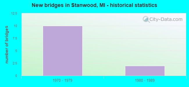
- New bridges - historical statistics
- 101970-1979
- 21980-1989


- Bridge Condition - Deck
- 66.7%Good
- 33.3%Satisfactory

- Bridge Condition - Superstructure
- 16.7%Very good
- 50.0%Good
- 33.3%Satisfactory
Find on map >> Show street view
Structure Number: 6713, Location: 2.5 MI SW OF STANWOOD (Lat: 43.554864, Lng: -85.489031), Route carried "on" structure: US 131, Year Built: 1979, Status: Open, Structure Length: 2.90m (9.51ft), Average Daily Traffic: 15,218 (year 2012), Truck Traffic: 11%, Average Future Daily Traffic: 11,777 (year 2018), Design Load: HS 25 or greater, Features Intersected: SIX MILE ROAD
Minimum Vertical Clearance: 30.48m (100.00ft), Kilometerpoint: 9.755, Lanes on structure: 3, Lanes under structure: 2, Base Highway Network: Yes (Inventory Route: 180, Subroute: 10), Owner: State Highway Agency, Approaching Roadway Width: 12.8m (42.0ft), Skew: 1 degrees, Material/Design: Steel, Design/Construction: Stringer/Multi-beam, Number Of Spans In Main Unit: 1, Length of Maximum Span: 27.9m (91.5ft), Curb-To-Curb Width: 12.8m (42.0ft), Out-to-Out Width: 14.0m (45.9ft)
Condition: Deck: Good, Superstructure: Good, Substructure: Good, Operating Rating: 86.5 metric tons, Method Used To Determine Operating Rating: Load Factor (LF) rating reported by rating factor (RF) method using MS18 loading, Inventory Rating: 51.8 metric tons, Method Used To Determine Inventory Rating: Load Factor (LF) rating reported by rating factor (RF) method using MS18 loading, Structural Evaluation: Better than present minimum criteria, Deck Geometry: Meets minimum limits, Underclear: Somewhat better than minimum adequacy, Approach Roadway Alignment: Equal to present desirable criteria, Length Of Structure Improvement: 2.90m (9.51ft), Designated Inspection Frequency: Every 24 months, Inspection Date: August 2021, Bridge Improvement Cost: $66,000, Roadway Improvement Cost: $4,000, Total Project Cost: $42,000, Deck Structure Type: Concrete Cast-file-Place, Wearing Surface/Protective System: Wearing Surface: Epoxy Overlay, Deck Protection: Epoxy Coated Reinforcing
Find on map >> Show street view
Structure Number: 6714, Location: 2.5 MI SW OF STANWOOD (Lat: 43.554872, Lng: -85.487875), Route carried "on" structure: US 131, Year Built: 1979, Status: Open, Structure Length: 2.90m (9.51ft), Average Daily Traffic: 15,218 (year 2012), Truck Traffic: 12%, Average Future Daily Traffic: 11,777 (year 2018), Design Load: HS 25 or greater, Features Intersected: SIX MILE ROAD
Minimum Vertical Clearance: 30.48m (100.00ft), Kilometerpoint: 9.750, Lanes on structure: 2, Lanes under structure: 2, Base Highway Network: Yes (Inventory Route: 180, Subroute: 5), Owner: State Highway Agency, Approaching Roadway Width: 12.8m (42.0ft), Skew: 1 degrees, Material/Design: Steel, Design/Construction: Stringer/Multi-beam, Number Of Spans In Main Unit: 1, Length of Maximum Span: 27.9m (91.5ft), Curb-To-Curb Width: 12.8m (42.0ft), Out-to-Out Width: 14.0m (45.9ft)
Condition: Deck: Satisfactory, Superstructure: Good, Substructure: Good, Operating Rating: 85.9 metric tons, Method Used To Determine Operating Rating: Load Factor (LF) rating reported by rating factor (RF) method using MS18 loading, Inventory Rating: 51.5 metric tons, Method Used To Determine Inventory Rating: Load Factor (LF) rating reported by rating factor (RF) method using MS18 loading, Structural Evaluation: Better than present minimum criteria, Deck Geometry: Equal to present desirable criteria, Underclear: Somewhat better than minimum adequacy, Approach Roadway Alignment: Equal to present desirable criteria, Length Of Structure Improvement: 2.90m (9.51ft), Designated Inspection Frequency: Every 24 months, Inspection Date: August 2021, Bridge Improvement Cost: $66,000, Roadway Improvement Cost: $4,000, Total Project Cost: $42,000, Deck Structure Type: Concrete Cast-file-Place, Wearing Surface/Protective System: Wearing Surface: Epoxy Overlay, Deck Protection: Epoxy Coated Reinforcing
Find on map >> Show street view
Structure Number: 6717, Location: 5 MI SOUTH BIG RAPIDS (Lat: 43.608058, Lng: -85.493886), Route carried "on" structure: US 131, Year Built: 1983, Status: Open, Structure Length: 17.68m (58.01ft), Average Daily Traffic: 18,000 (year 2012), Truck Traffic: 9%, Average Future Daily Traffic: 20,700 (year 2032), Design Load: HS 25 or greater, Features Intersected: MUSKEGON RIVER
Minimum Vertical Clearance: 30.48m (100.00ft), Kilometerpoint: 15.875, Lanes on structure: 2, Base Highway Network: Yes (Inventory Route: 180, Subroute: 10), Owner: State Highway Agency, Approaching Roadway Width: 12.8m (42.0ft), Material/Design: Prestressed concrete continuous, Design/Construction: Segmental Box Girder, Number Of Spans In Main Unit: 3, Length of Maximum Span: 82.3m (270.0ft), Curb or Sidewalk Widths: Left: 0.6m (2.0ft), Right: 0.6m (2.0ft), Curb-To-Curb Width: 12.8m (42.0ft), Out-to-Out Width: 14.0m (45.9ft)
Condition: Deck: Satisfactory, Superstructure: Satisfactory, Substructure: Good, Channel: Good, Operating Rating: 70.6 metric tons, Method Used To Determine Operating Rating: Load and Resistance Factor Rating (LRFR) rating reported by rating factor(RF) method using HL-93 loadings, Inventory Rating: 36.9 metric tons, Method Used To Determine Inventory Rating: Load and Resistance Factor Rating (LRFR) rating reported by rating factor(RF) method using HL-93 loadings, Structural Evaluation: Equal to present minimum criteria, Deck Geometry: Equal to present desirable criteria, Waterway Adequacy: Equal to present minimum criteria, Approach Roadway Alignment: Equal to present desirable criteria, Designated Inspection Frequency: Every 24 months, Inspection Date: July 2021, Deck Structure Type: Concrete Cast-file-Place, Wearing Surface/Protective System: Wearing Surface: Epoxy Overlay, Deck Protection: Epoxy Coated Reinforcing
Find on map >> Show street view
Structure Number: 6718, Location: 5 MI SOUTH BIG RAPIDS (Lat: 43.608147, Lng: -85.492703), Route carried "on" structure: US 131, Year Built: 1982, Status: Open, Structure Length: 17.68m (58.01ft), Average Daily Traffic: 18,000 (year 2012), Truck Traffic: 9%, Average Future Daily Traffic: 20,700 (year 2032), Design Load: HS 25 or greater, Features Intersected: MUSKEGON RIVER
Minimum Vertical Clearance: 30.48m (100.00ft), Kilometerpoint: 15.853, Lanes on structure: 2, Base Highway Network: Yes (Inventory Route: 180, Subroute: 5), Owner: State Highway Agency, Approaching Roadway Width: 12.8m (42.0ft), Material/Design: Prestressed concrete continuous, Design/Construction: Segmental Box Girder, Number Of Spans In Main Unit: 3, Length of Maximum Span: 82.3m (270.0ft), Curb or Sidewalk Widths: Left: 0.6m (2.0ft), Right: 0.6m (2.0ft), Curb-To-Curb Width: 12.8m (42.0ft), Out-to-Out Width: 14.0m (45.9ft)
Condition: Deck: Good, Superstructure: Satisfactory, Substructure: Good, Channel: Good, Operating Rating: 70.6 metric tons, Method Used To Determine Operating Rating: Load and Resistance Factor Rating (LRFR) rating reported by rating factor(RF) method using HL-93 loadings, Inventory Rating: 36.9 metric tons, Method Used To Determine Inventory Rating: Load and Resistance Factor Rating (LRFR) rating reported by rating factor(RF) method using HL-93 loadings, Structural Evaluation: Equal to present minimum criteria, Deck Geometry: Equal to present desirable criteria, Waterway Adequacy: Equal to present minimum criteria, Approach Roadway Alignment: Equal to present desirable criteria, Designated Inspection Frequency: Every 24 months, Inspection Date: July 2021, Deck Structure Type: Concrete Cast-file-Place, Wearing Surface/Protective System: Wearing Surface: Epoxy Overlay, Deck Protection: Epoxy Coated Reinforcing
Find on map >> Show street view
Structure Number: 6728, Location: 5.5 MI S OF BIG RAPIDS (Lat: 43.596936, Lng: -85.488611), Route carried "on" structure: County highway 5406, Year Built: 1979, Status: Open, Structure Length: 7.16m (23.49ft), Average Daily Traffic: 480 (year 1981), Truck Traffic: 3%, Average Future Daily Traffic: 480 (year 2015), Design Load: HS 20, Features Intersected: US-131 SB, Facility Carried by Structure: OLD STATE ROAD
Minimum Vertical Clearance: 30.48m (100.00ft), Kilometerpoint: 7.162, Lanes on structure: 2, Lanes under structure: 2, Base Highway Network: Yes (Inventory Route: 52, Subroute: 4), Owner: State Highway Agency, Approaching Roadway Width: 13.7m (44.9ft), Skew: 4 degrees, Material/Design: Steel, Design/Construction: Stringer/Multi-beam, Number Of Spans In Main Unit: 3, Length of Maximum Span: 39.6m (129.9ft), Curb-To-Curb Width: 13.2m (43.3ft), Out-to-Out Width: 13.9m (45.6ft)
Condition: Deck: Good, Superstructure: Good, Substructure: Good, Operating Rating: 80.0 metric tons, Method Used To Determine Operating Rating: Load Factor (LF) rating reported by rating factor (RF) method using MS18 loading, Inventory Rating: 48.0 metric tons, Method Used To Determine Inventory Rating: Load Factor (LF) rating reported by rating factor (RF) method using MS18 loading, Structural Evaluation: Better than present minimum criteria, Deck Geometry: Superior to present desirable criteria, Underclear: Superior to present desirable criteria, Approach Roadway Alignment: Equal to present desirable criteria, Length Of Structure Improvement: 7.16m (23.49ft), Designated Inspection Frequency: Every 24 months, Inspection Date: May 2021, Bridge Improvement Cost: $153,000, Roadway Improvement Cost: $9,000, Total Project Cost: $104,000, Deck Structure Type: Concrete Cast-file-Place, Wearing Surface/Protective System: Wearing Surface: Monolithic Concrete
Find on map >> Show street view
Structure Number: 6729, Location: 5.5 MI S OF BIG RAPIDS (Lat: 43.597958, Lng: -85.487617), Route carried "on" structure: County highway 5406, Year Built: 1979, Status: Open, Structure Length: 6.73m (22.08ft), Average Daily Traffic: 480 (year 1981), Truck Traffic: 3%, Average Future Daily Traffic: 480 (year 1977), Design Load: HS 20, Features Intersected: US-131 NB, Facility Carried by Structure: OLD STATE ROAD
Minimum Vertical Clearance: 30.48m (100.00ft), Kilometerpoint: 7.300, Lanes on structure: 2, Lanes under structure: 2, Base Highway Network: Yes (Inventory Route: 52, Subroute: 4), Owner: State Highway Agency, Approaching Roadway Width: 10.0m (32.8ft), Skew: 4 degrees, Material/Design: Steel, Design/Construction: Stringer/Multi-beam, Number Of Spans In Main Unit: 3, Length of Maximum Span: 38.1m (125.0ft), Curb-To-Curb Width: 13.2m (43.3ft), Out-to-Out Width: 13.9m (45.6ft)
Condition: Deck: Good, Superstructure: Very good, Substructure: Good, Operating Rating: 88.8 metric tons, Method Used To Determine Operating Rating: Load Factor (LF) rating reported by rating factor (RF) method using MS18 loading, Inventory Rating: 53.5 metric tons, Method Used To Determine Inventory Rating: Load Factor (LF) rating reported by rating factor (RF) method using MS18 loading, Structural Evaluation: Better than present minimum criteria, Deck Geometry: Superior to present desirable criteria, Underclear: Better than present minimum criteria, Approach Roadway Alignment: Equal to present desirable criteria, Length Of Structure Improvement: 6.74m (22.11ft), Designated Inspection Frequency: Every 24 months, Inspection Date: May 2021, Bridge Improvement Cost: $158,000, Roadway Improvement Cost: $8,000, Total Project Cost: $96,000, Deck Structure Type: Concrete Cast-file-Place, Wearing Surface/Protective System: Wearing Surface: Latex Concrete, Deck Protection: Epoxy Coated Reinforcing
Find on map >> Show street view
Structure Number: 6713, Location: 2.5 MI SW OF STANWOOD (Lat: 43.554864, Lng: -85.489031), Route carried "under" structure: City street 1, Year Built: 1979, Structure Length: 0. m, Average Daily Traffic: 50 (year 1988), Features Intersected: SIX MILE ROAD
Minimum Vertical Clearance: 4.70m (15.42ft), Kilometerpoint: 0.233, Lanes on structure: 3, Lanes under structure: 2, Material/Design: Steel, Design/Construction: Stringer/Multi-beam, Length of Maximum Span: 27.9m (91.5ft)
Find on map >> Show street view
Structure Number: 6714, Location: 2.5 MI SW OF STANWOOD (Lat: 43.554872, Lng: -85.487875), Route carried "under" structure: City street , Year Built: 1979, Structure Length: 0. m, Average Daily Traffic: 50 (year 1988), Features Intersected: SIX MILE ROAD, Facility Carried by Structure: US-131 NB
Minimum Vertical Clearance: 4.39m (14.40ft), Kilometerpoint: 0.327, Lanes on structure: 2, Lanes under structure: 2, Material/Design: Steel, Design/Construction: Stringer/Multi-beam, Length of Maximum Span: 27.9m (91.5ft)
Find on map >> Show street view
Structure Number: 6715, Location: WEST OF STANWOOD (Lat: 43.583619, Lng: -85.489600), Route carried "under" structure: State highway 20, Year Built: 1979, Structure Length: 0. m, Average Daily Traffic: 3,615 (year 2007), Truck Traffic: 12%, Features Intersected: M-20 (8 MILE ROAD), Facility Carried by Structure: US-131 SB
Minimum Vertical Clearance: 5.03m (16.50ft), Kilometerpoint: 5.828, Lanes on structure: 2, Lanes under structure: 2, Material/Design: Steel, Design/Construction: Stringer/Multi-beam, Length of Maximum Span: 41.1m (134.8ft)
Find on map >> Show street view
Structure Number: 6716, Location: WEST OF STANWOOD (Lat: 43.583603, Lng: -85.488836), Route carried "under" structure: State highway 20, Year Built: 1979, Structure Length: 0. m, Average Daily Traffic: 5,151 (year 2007), Truck Traffic: 2%, Features Intersected: M-20 (8 MILE ROAD), Facility Carried by Structure: US-131 NB
Minimum Vertical Clearance: 5.03m (16.50ft), Kilometerpoint: 5.890, Lanes on structure: 2, Lanes under structure: 2, Material/Design: Steel, Design/Construction: Stringer/Multi-beam, Length of Maximum Span: 41.1m (134.8ft)
Find on map >> Show street view
Structure Number: 6728, Location: 5.5 MI S OF BIG RAPIDS (Lat: 43.596936, Lng: -85.488611), Route carried "under" structure: US 131, Year Built: 1979, Structure Length: 0. m, Average Daily Traffic: 7,789 (year 2007), Truck Traffic: 13%, Features Intersected: US-131 SB, Facility Carried by Structure: OLD STATE ROAD
Minimum Vertical Clearance: 5.33m (17.49ft), Kilometerpoint: 14.473, Lanes on structure: 2, Lanes under structure: 2, Material/Design: Steel, Design/Construction: Stringer/Multi-beam, Length of Maximum Span: 39.6m (129.9ft)
Find on map >> Show street view
Structure Number: 6729, Location: 5.5 MI S OF BIG RAPIDS (Lat: 43.597958, Lng: -85.487617), Route carried "under" structure: US 131, Year Built: 1979, Structure Length: 0. m, Average Daily Traffic: 7,789 (year 2007), Truck Traffic: 13%, Features Intersected: US-131 NB, Facility Carried by Structure: OLD STATE ROAD
Minimum Vertical Clearance: 5.00m (16.40ft), Kilometerpoint: 14.575, Lanes on structure: 2, Lanes under structure: 2, Material/Design: Steel, Design/Construction: Stringer/Multi-beam, Length of Maximum Span: 38.1m (125.0ft)