Bridge Statistics for Stanfield, Arizona (AZ)
Condition, Traffic, Stress, Structural Evaluation, Project Costs
- National Bridge Inventory (NBI) Statistics
- 12Number of bridges
- 118ft / 36.5mTotal length
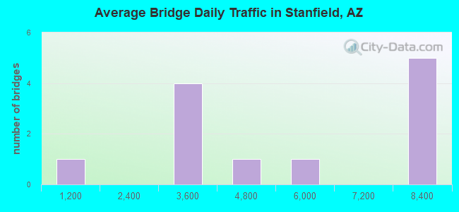
- 57,807Total average daily traffic
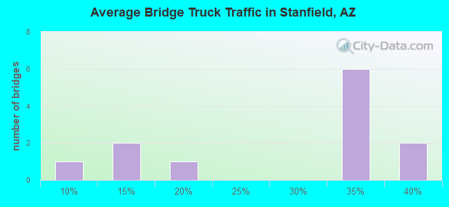
- 17,286Total average daily truck traffic
- National Bridge Inventory (NBI) Registered Bridges for Stanfield
- No street view available for this location
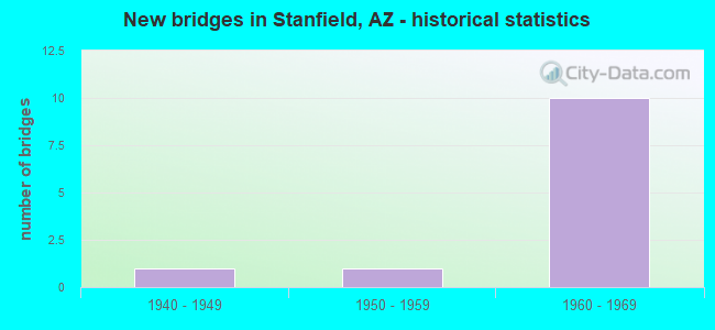
- New bridges - historical statistics
- 11940-1949
- 11950-1959
- 101960-1969
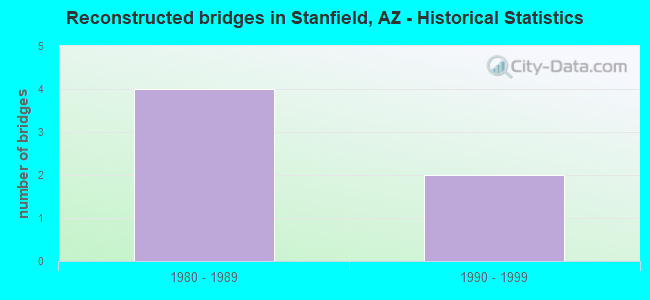
- Reconstructed bridges - Historical Statistics
- 41980-1989
- 21990-1999
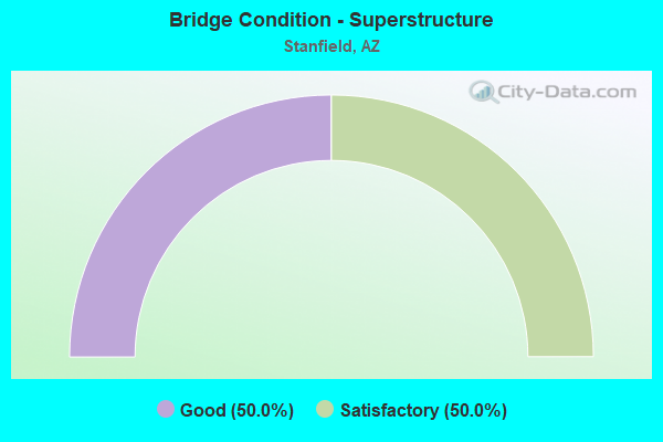
- Bridge Condition - Superstructure
- 50.0%Good
- 50.0%Satisfactory
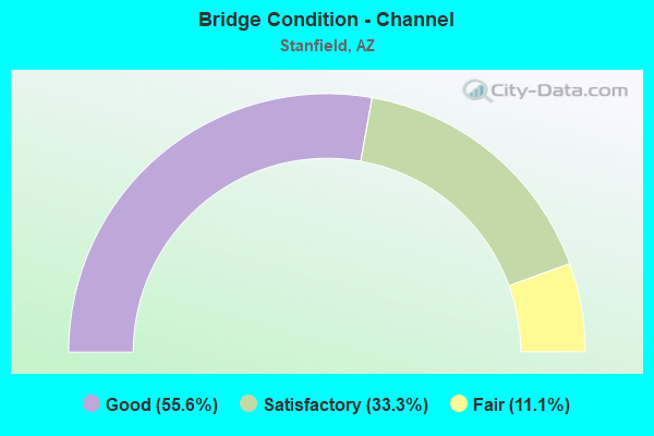
- Bridge Condition - Channel
- 55.6%Good
- 33.3%Satisfactory
- 11.1%Fair
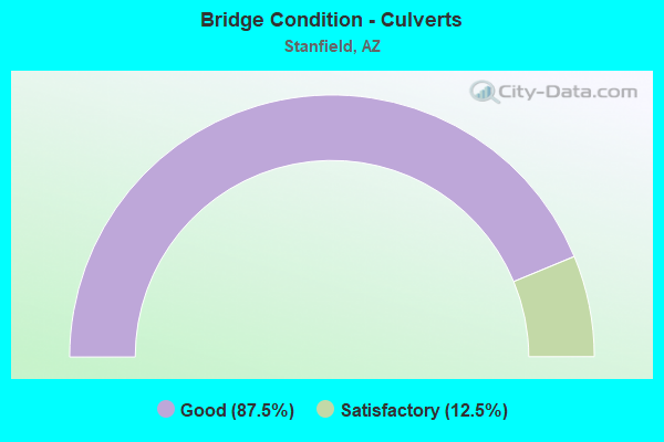
- Bridge Condition - Culverts
- 87.5%Good
- 12.5%Satisfactory
Find on map >> Show street view
Structure Number: 109, Location: 9.9 mi East Jct SR 84 (Lat: 32.827900, Lng: -111.963600), Route carried "on" structure: County highway , Year Built: 1965, Status: Open, Structure Length: 9.02m (29.59ft), Average Daily Traffic: 687 (year 2021), Truck Traffic: 5%, Average Future Daily Traffic: 697 (year 2041), Design Load: HS 20, Features Intersected: I 8, Facility Carried by Structure: Stanfield Road
Minimum Vertical Clearance: 30+ m (98+ ft), Kilometerpoint: 0.000, Lanes on structure: 2, Lanes under structure: 5, Owner: State Highway Agency, Approaching Roadway Width: 9.1m (29.9ft), Material/Design: Steel continuous, Design/Construction: Stringer/Multi-beam, Number Of Spans In Main Unit: 4, Length of Maximum Span: 28.0m (91.9ft), Curb or Sidewalk Widths: Left: 0.5m (1.6ft), Right: 0.5m (1.6ft), Curb-To-Curb Width: 9.1m (29.9ft), Out-to-Out Width: 10.8m (35.4ft)
Condition: Deck: Satisfactory, Superstructure: Good, Substructure: Satisfactory, Operating Rating: 53.5 metric tons, Method Used To Determine Operating Rating: Load Factor (LF), Inventory Rating: 32.7 metric tons, Method Used To Determine Inventory Rating: Load Factor (LF), Structural Evaluation: Equal to present minimum criteria, Deck Geometry: Equal to present minimum criteria, Underclear: High priority of corrective action, Approach Roadway Alignment: Equal to present desirable criteria, Designated Inspection Frequency: Every 24 months, Inspection Date: October 2021, Deck Structure Type: Concrete Cast-file-Place, Wearing Surface/Protective System: Wearing Surface: Monolithic Concrete
Find on map >> Show street view
Structure Number: 1092, Location: 11.3 mi E Jct SR 84 (Lat: 32.828069, Lng: -111.938203), Route carried "on" structure: Interstate 8, Year Built: 1965, Status: Open, Structure Length: 18.90m (62.01ft), Average Daily Traffic: 3,767 (year 2018), Truck Traffic: 19%, Average Future Daily Traffic: 3,777 (year 2038), Design Load: HS 20, Features Intersected: Santa Rosa Wash
Minimum Vertical Clearance: 30+ m (98+ ft), Kilometerpoint: 262.323, Lanes on structure: 2, Owner: State Highway Agency, Approaching Roadway Width: 9.8m (32.2ft), Material/Design: Concrete continuous, Design/Construction: Slab, Number Of Spans In Main Unit: 18, Length of Maximum Span: 10.7m (35.1ft), Curb-To-Curb Width: 9.8m (32.2ft), Out-to-Out Width: 10.7m (35.1ft)
Condition: Deck: Satisfactory, Superstructure: Satisfactory, Substructure: Satisfactory, Channel: Satisfactory, Operating Rating: 59.0 metric tons, Method Used To Determine Operating Rating: Load Factor (LF), Inventory Rating: 35.4 metric tons, Method Used To Determine Inventory Rating: Load Factor (LF), Structural Evaluation: Equal to present minimum criteria, Deck Geometry: Meets minimum limits, Waterway Adequacy: Better than present minimum criteria, Approach Roadway Alignment: Equal to present desirable criteria, Designated Inspection Frequency: Every 24 months, Inspection Date: Febuary 2022, Deck Structure Type: Concrete Cast-file-Place, Wearing Surface/Protective System: Wearing Surface: Bituminous
Find on map >> Show street view
Structure Number: 4547, Location: 9.4 mi E Jct I-8 (Lat: 32.879400, Lng: -111.986600), Route carried "on" structure: State highway 84, Year Built: 1946, Year Reconstructed: 2004, Status: Open, Structure Length: 0.64m (2.10ft), Average Daily Traffic: 3,076 (year 2016), Truck Traffic: 11%, Average Future Daily Traffic: 7,215 (year 2036), Design Load: HS 20, Features Intersected: Wash
Minimum Vertical Clearance: 30+ m (98+ ft), Kilometerpoint: 264.990, Lanes on structure: 2, Owner: State Highway Agency, Approaching Roadway Width: 12.2m (40.0ft), Material/Design: Concrete continuous, Design/Construction: Culvert, Number Of Spans In Main Unit: 2, Length of Maximum Span: 3.0m (9.8ft)
Condition: Channel: Good, Culverts: Satisfactory, Operating Rating: 52.6 metric tons, Method Used To Determine Operating Rating: Load Factor (LF), Inventory Rating: 32.7 metric tons, Method Used To Determine Inventory Rating: Load Factor (LF), Structural Evaluation: Equal to present minimum criteria, Waterway Adequacy: Equal to present minimum criteria, Approach Roadway Alignment: Equal to present desirable criteria, Designated Inspection Frequency: Every 48 months, Inspection Date: Febuary 2022, Deck Structure Type: Concrete Cast-file-Place, Wearing Surface/Protective System: Wearing Surface: Bituminous
Find on map >> Show street view
Structure Number: 4548, Location: 9.4 mi E Jct I-8 (Lat: 32.879400, Lng: -111.980800), Route carried "on" structure: State highway 84, Year Built: 1959, Year Reconstructed: 2004, Status: Open, Structure Length: 2.65m (8.69ft), Average Daily Traffic: 3,076 (year 2016), Truck Traffic: 11%, Average Future Daily Traffic: 7,215 (year 2036), Design Load: HS 20, Features Intersected: Wash
Minimum Vertical Clearance: 30+ m (98+ ft), Kilometerpoint: 265.540, Lanes on structure: 2, Owner: State Highway Agency, Approaching Roadway Width: 12.2m (40.0ft), Skew: 3 degrees, Material/Design: Concrete continuous, Design/Construction: Culvert, Number Of Spans In Main Unit: 7, Length of Maximum Span: 3.0m (9.8ft)
Condition: Channel: Fair, Culverts: Good, Operating Rating: 49.9 metric tons, Method Used To Determine Operating Rating: Load Factor (LF), Inventory Rating: 29.9 metric tons, Method Used To Determine Inventory Rating: Load Factor (LF), Structural Evaluation: Better than present minimum criteria, Waterway Adequacy: Better than present minimum criteria, Approach Roadway Alignment: Equal to present desirable criteria, Designated Inspection Frequency: Every 48 months, Inspection Date: Febuary 2022, Deck Structure Type: Concrete Cast-file-Place, Wearing Surface/Protective System: Wearing Surface: Bituminous
Find on map >> Show street view
Structure Number: 5317, Location: 8.1 mi East Jct SR 84 (Lat: 32.829400, Lng: -112.009100), Route carried "on" structure: Interstate 8, Year Built: 1962, Status: Open, Structure Length: 0.64m (2.10ft), Average Daily Traffic: 2,769 (year 2019), Truck Traffic: 33%, Average Future Daily Traffic: 2,779 (year 2039), Design Load: HS 20, Features Intersected: Wash
Minimum Vertical Clearance: 30+ m (98+ ft), Kilometerpoint: 257.238, Lanes on structure: 2, Owner: State Highway Agency, Approaching Roadway Width: 11.6m (38.1ft), Material/Design: Concrete continuous, Design/Construction: Culvert, Number Of Spans In Main Unit: 2, Length of Maximum Span: 3.0m (9.8ft)
Condition: Channel: Satisfactory, Culverts: Good, Operating Rating: 64.4 metric tons, Method Used To Determine Operating Rating: Load Factor (LF), Inventory Rating: 38.1 metric tons, Method Used To Determine Inventory Rating: Load Factor (LF), Structural Evaluation: Better than present minimum criteria, Waterway Adequacy: Equal to present desirable criteria, Approach Roadway Alignment: Equal to present desirable criteria, Designated Inspection Frequency: Every 48 months, Inspection Date: January 2021
Find on map >> Show street view
Structure Number: 5318, Location: 8.1 mi East Jct SR 84 (Lat: 32.830000, Lng: -112.009100), Route carried "on" structure: Interstate 8, Year Built: 1962, Status: Open, Structure Length: 0.64m (2.10ft), Average Daily Traffic: 2,769 (year 2019), Truck Traffic: 33%, Average Future Daily Traffic: 2,779 (year 2039), Design Load: HS 20, Features Intersected: Wash
Minimum Vertical Clearance: 30+ m (98+ ft), Kilometerpoint: 257.238, Lanes on structure: 2, Owner: State Highway Agency, Approaching Roadway Width: 11.6m (38.1ft), Material/Design: Concrete continuous, Design/Construction: Culvert, Number Of Spans In Main Unit: 2, Length of Maximum Span: 3.0m (9.8ft)
Condition: Channel: Good, Culverts: Good, Operating Rating: 89.8 metric tons, Method Used To Determine Operating Rating: Load Factor (LF), Inventory Rating: 76.2 metric tons, Method Used To Determine Inventory Rating: Load Factor (LF), Structural Evaluation: Better than present minimum criteria, Waterway Adequacy: Equal to present desirable criteria, Approach Roadway Alignment: Equal to present desirable criteria, Designated Inspection Frequency: Every 48 months, Inspection Date: January 2021
Find on map >> Show street view
Structure Number: 5319, Location: 9.8 mi East Jct SR 84 (Lat: 32.828300, Lng: -111.964100), Route carried "on" structure: Interstate 8, Year Built: 1965, Year Reconstructed: 1986, Status: Open, Structure Length: 1.95m (6.40ft), Average Daily Traffic: 5,538 (year 2019), Truck Traffic: 33%, Average Future Daily Traffic: 5,548 (year 2039), Design Load: HS 20, Features Intersected: Wash
Minimum Vertical Clearance: 30+ m (98+ ft), Kilometerpoint: 259.925, Lanes on structure: 5, Owner: State Highway Agency, Approaching Roadway Width: 23.2m (76.1ft), Skew: 30 degrees, Material/Design: Concrete continuous, Design/Construction: Culvert, Number Of Spans In Main Unit: 6, Length of Maximum Span: 3.0m (9.8ft)
Condition: Channel: Good, Culverts: Good, Operating Rating: 89.8 metric tons, Method Used To Determine Operating Rating: Load Factor (LF), Inventory Rating: 74.4 metric tons, Method Used To Determine Inventory Rating: Load Factor (LF), Structural Evaluation: Better than present minimum criteria, Waterway Adequacy: Equal to present desirable criteria, Approach Roadway Alignment: Equal to present desirable criteria, Designated Inspection Frequency: Every 48 months, Inspection Date: January 2021
Find on map >> Show street view
Structure Number: 5321, Location: 10.8 mi E Jct SR 84 (Lat: 32.828200, Lng: -111.945500), Route carried "on" structure: Interstate 8, Year Built: 1965, Year Reconstructed: 1986, Status: Open, Structure Length: 0.64m (2.10ft), Average Daily Traffic: 7,225 (year 2019), Truck Traffic: 33%, Average Future Daily Traffic: 7,235 (year 2039), Design Load: HS 20, Features Intersected: Wash
Minimum Vertical Clearance: 30+ m (98+ ft), Kilometerpoint: 261.551, Lanes on structure: 4, Owner: State Highway Agency, Approaching Roadway Width: 23.2m (76.1ft), Skew: 30 degrees, Material/Design: Concrete continuous, Design/Construction: Culvert, Number Of Spans In Main Unit: 2, Length of Maximum Span: 3.0m (9.8ft)
Condition: Channel: Good, Culverts: Good, Operating Rating: 64.4 metric tons, Method Used To Determine Operating Rating: Load Factor (LF), Inventory Rating: 38.1 metric tons, Method Used To Determine Inventory Rating: Load Factor (LF), Structural Evaluation: Better than present minimum criteria, Waterway Adequacy: Equal to present desirable criteria, Approach Roadway Alignment: Equal to present desirable criteria, Designated Inspection Frequency: Every 48 months, Inspection Date: January 2021
Find on map >> Show street view
Structure Number: 5323, Location: 10.9 mi E Jct SR 84 (Lat: 32.828200, Lng: -111.933400), Route carried "on" structure: Interstate 8, Year Built: 1965, Year Reconstructed: 1986, Status: Open, Structure Length: 0.73m (2.40ft), Average Daily Traffic: 7,225 (year 2019), Truck Traffic: 33%, Average Future Daily Traffic: 7,235 (year 2039), Design Load: HS 20, Features Intersected: Wash
Minimum Vertical Clearance: 30+ m (98+ ft), Kilometerpoint: 262.822, Lanes on structure: 4, Owner: State Highway Agency, Approaching Roadway Width: 23.2m (76.1ft), Skew: 33 degrees, Material/Design: Concrete continuous, Design/Construction: Culvert, Number Of Spans In Main Unit: 2, Length of Maximum Span: 3.0m (9.8ft), Out-to-Out Width: 3.0m (9.8ft)
Condition: Channel: Satisfactory, Culverts: Good, Operating Rating: 89.8 metric tons, Method Used To Determine Operating Rating: Load Factor (LF), Inventory Rating: 79.8 metric tons, Method Used To Determine Inventory Rating: Load Factor (LF), Structural Evaluation: Better than present minimum criteria, Waterway Adequacy: Equal to present desirable criteria, Approach Roadway Alignment: Equal to present desirable criteria, Designated Inspection Frequency: Every 48 months, Inspection Date: January 2021
Find on map >> Show street view
Structure Number: 5325, Location: 11.8 mi E Jct SR 84 (Lat: 32.828200, Lng: -111.929300), Route carried "on" structure: Interstate 8, Year Built: 1965, Year Reconstructed: 1986, Status: Open, Structure Length: 0.64m (2.10ft), Average Daily Traffic: 7,225 (year 2019), Truck Traffic: 33%, Average Future Daily Traffic: 7,235 (year 2039), Design Load: HS 20, Features Intersected: Wash
Minimum Vertical Clearance: 30+ m (98+ ft), Kilometerpoint: 263.160, Lanes on structure: 4, Owner: State Highway Agency, Approaching Roadway Width: 23.2m (76.1ft), Skew: 30 degrees, Material/Design: Concrete continuous, Design/Construction: Culvert, Number Of Spans In Main Unit: 2, Length of Maximum Span: 3.0m (9.8ft)
Condition: Channel: Good, Culverts: Good, Operating Rating: 89.8 metric tons, Method Used To Determine Operating Rating: Load Factor (LF), Inventory Rating: 76.2 metric tons, Method Used To Determine Inventory Rating: Load Factor (LF), Structural Evaluation: Better than present minimum criteria, Waterway Adequacy: Equal to present desirable criteria, Approach Roadway Alignment: Equal to present desirable criteria, Designated Inspection Frequency: Every 48 months, Inspection Date: January 2021
Find on map >> Show street view
Structure Number: 109, Location: 9.9 mi East Jct SR 84 (Lat: 32.827900, Lng: -111.963600), Route carried "under" structure: Interstate 8, Year Built: 1965, Structure Length: 0. m, Average Daily Traffic: 7,225 (year 2019), Truck Traffic: 35%, Features Intersected: I 8, Facility Carried by Structure: Stanfield Road
Minimum Vertical Clearance: 5.05m (16.57ft), Kilometerpoint: 260.070, Lanes on structure: 2, Lanes under structure: 2, Material/Design: Steel continuous, Design/Construction: Stringer/Multi-beam, Length of Maximum Span: 28.0m (91.9ft)
Find on map >> Show street view
Structure Number: 1091, Location: 10.8 mi East Jct SR 84 (Lat: 32.827900, Lng: -111.946400), Route carried "under" structure: Interstate 8, Year Built: 1965, Structure Length: 0. m, Average Daily Traffic: 7,225 (year 2019), Truck Traffic: 35%, Features Intersected: I 8, Facility Carried by Structure: Murphy Rd
Minimum Vertical Clearance: 5.05m (16.57ft), Kilometerpoint: 261.518, Lanes on structure: 2, Lanes under structure: 2, Material/Design: Steel continuous, Design/Construction: Stringer/Multi-beam, Length of Maximum Span: 23.8m (78.1ft)