Bridge Statistics for St. Rose, Louisiana (LA)
Condition, Traffic, Stress, Structural Evaluation, Project Costs
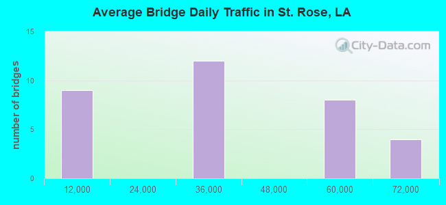
- National Bridge Inventory (NBI) Statistics
- 33Number of bridges
- 1,003,070Total average daily traffic
- National Bridge Inventory (NBI) Registered Bridges for St. Rose
- No street view available for this location
Find on map >> Show street view
Structure Number: 24504503600401, Location: 1.7 MI N OF LA 48 (Lat: 29.968200, Lng: -90.328611), Route carried "under" structure: State highway 626, Structure Length: 0. m, Average Daily Traffic: 3,000 (year 2016), Features Intersected: LA 626 UNDER I-310
Minimum Vertical Clearance: 4.69m (15.39ft), Kilometerpoint: 2.757, Lanes on structure: 2, Length of Maximum Span: 0.0m
Find on map >> Show street view
Structure Number: 24504503600401, Location: 4.6 MI W OF LA 49 (Lat: 29.975369, Lng: -90.319019), Route carried "under" structure: US 61, Structure Length: 0. m, Average Daily Traffic: 25,300 (year 2015), Features Intersected: US 61 NB UNDER I-310 SB
Minimum Vertical Clearance: 5.55m (18.21ft), Kilometerpoint: 3.928, Lanes on structure: 2, Length of Maximum Span: 0.0m
Find on map >> Show street view
Structure Number: 24504503600401, Location: 0.9 MI E OF LA 626 (Lat: 29.975261, Lng: -90.319369), Route carried "under" structure: US 61, Structure Length: 0. m, Average Daily Traffic: 25,300 (year 2015), Features Intersected: US 61 SB UNDER I-310 SB
Minimum Vertical Clearance: 5.79m (19.00ft), Kilometerpoint: 14.256, Lanes on structure: 2, Length of Maximum Span: 0.0m
Find on map >> Show street view
Structure Number: 24504503600408, Location: 10.72 MI E OF US 51 (Lat: 30.006361, Lng: -90.291839), Route carried "under" structure: Interstate 10, Structure Length: 0. m, Average Daily Traffic: 63,200 (year 2015), Features Intersected: I-10 EB UNDER I-310 NB O
Minimum Vertical Clearance: 12.95m (42.49ft), Kilometerpoint: 14.093, Lanes on structure: 2, Length of Maximum Span: 0.0m
Find on map >> Show street view
Structure Number: 24504503600408, Location: 3.05 MI W OF LA 49 (Lat: 30.007019, Lng: -90.291769), Route carried "under" structure: Ramp Interstate 310, Structure Length: 0. m, Average Daily Traffic: 6,370 (year 2014), Features Intersected: I-310 SB ON RAMP FROM I-
Minimum Vertical Clearance: 6.01m (19.72ft), Kilometerpoint: 1.036, Lanes on structure: 2, Length of Maximum Span: 0.0m
Find on map >> Show street view
Structure Number: 24504503600408, Location: 3.05 MI W OF LA 49 (Lat: 30.006711, Lng: -90.291711), Route carried "under" structure: Interstate 10, Structure Length: 0. m, Average Daily Traffic: 63,200 (year 2015), Features Intersected: I-10 WB UNDER I-310 NB O
Minimum Vertical Clearance: 13.23m (43.41ft), Kilometerpoint: 1.423, Lanes on structure: 2, Length of Maximum Span: 0.0m
Find on map >> Show street view
Structure Number: 24504503600412, Location: 4.58 MI W OF LA 49 (Lat: 29.975281, Lng: -90.318861), Route carried "under" structure: US 61, Structure Length: 0. m, Average Daily Traffic: 25,300 (year 2015), Features Intersected: US 61 NB UNDER I-310 NB
Minimum Vertical Clearance: 5.33m (17.49ft), Kilometerpoint: 3.912, Lanes on structure: 2, Length of Maximum Span: 0.0m
Find on map >> Show street view
Structure Number: 24504503600412, Location: 0.92 MI E OF LA 626 (Lat: 29.975211, Lng: -90.319161), Route carried "under" structure: US 61, Structure Length: 0. m, Average Daily Traffic: 25,300 (year 2015), Features Intersected: US 61 SB UNDER I-310 NB
Minimum Vertical Clearance: 5.67m (18.60ft), Kilometerpoint: 14.276, Lanes on structure: 2, Length of Maximum Span: 0.0m
Find on map >> Show street view
Structure Number: 24504503600412, Location: 1.72 MI N OF LA 48 (Lat: 29.968931, Lng: -90.328900), Route carried "under" structure: State highway 626, Structure Length: 0. m, Average Daily Traffic: 3,000 (year 2016), Features Intersected: LA 626 UNDER I-310
Minimum Vertical Clearance: 5.00m (16.40ft), Kilometerpoint: 2.812, Lanes on structure: 2, Length of Maximum Span: 0.0m
Find on map >> Show street view
Structure Number: 24504503600425, Location: 10.7 MI E OF US 51 (Lat: 30.006461, Lng: -90.292469), Route carried "under" structure: Interstate 10, Structure Length: 0. m, Average Daily Traffic: 63,200 (year 2015), Features Intersected: I- 10 EB UNDER I-310 SB
Minimum Vertical Clearance: 5.61m (18.41ft), Kilometerpoint: 14.032, Lanes on structure: 2, Length of Maximum Span: 0.0m
Find on map >> Show street view
Structure Number: 24504503600425, Location: 3.1 MI W OF LA 49 (Lat: 30.006739, Lng: -90.291939), Route carried "under" structure: Interstate 10, Structure Length: 0. m, Average Daily Traffic: 63,200 (year 2015), Features Intersected: I-10 WB UNDER I-310 SB O
Minimum Vertical Clearance: 5.27m (17.29ft), Kilometerpoint: 1.447, Lanes on structure: 2, Length of Maximum Span: 0.0m
Find on map >> Show street view
Structure Number: 24504503602456, Location: 1.0 MI E OF LA 626 (Lat: 29.974850, Lng: -90.317889), Route carried "under" structure: US 61, Structure Length: 0. m, Average Daily Traffic: 25,300 (year 2015), Features Intersected: US 61 SB UNDER I-310 NB
Minimum Vertical Clearance: 23.17m (76.02ft), Kilometerpoint: 14.405, Lanes on structure: 2, Length of Maximum Span: 0.0m
Find on map >> Show street view
Structure Number: 24504503602456, Location: 4.5 MI W OF LA 49 (Lat: 29.974919, Lng: -90.317469), Route carried "under" structure: US 61, Structure Length: 0. m, Average Daily Traffic: 25,300 (year 2015), Features Intersected: US 61 NB UNDER I-310 NB
Minimum Vertical Clearance: 22.65m (74.31ft), Kilometerpoint: 3.774, Lanes on structure: 2, Length of Maximum Span: 0.0m
Find on map >> Show street view
Structure Number: 24504503602456, Location: 0.534 MI N OF US 61 (Lat: 29.975731, Lng: -90.316211), Route carried "under" structure: Ramp Interstate 310, Structure Length: 0. m, Average Daily Traffic: 5,050 (year 0000), Features Intersected: I-310 ON RAMP FROM US 61
Minimum Vertical Clearance: 5.85m (19.19ft), Kilometerpoint: 0.859, Lanes on structure: 1, Length of Maximum Span: 0.0m
Find on map >> Show street view
Structure Number: 24504503602456, Location: 0.2 MI. N. OF US 61 (Lat: 29.974531, Lng: -90.320061), Route carried "under" structure: Interstate 310, Structure Length: 0. m, Average Daily Traffic: 50,500 (year 2014), Features Intersected: I-310 NB @ I-310 ON-RAMP
Minimum Vertical Clearance: 8.38m (27.49ft), Kilometerpoint: 6.544, Lanes on structure: 1, Lanes under structure: 2, Length of Maximum Span: 0.0m
Find on map >> Show street view
Structure Number: 24504503602456, Location: 3.05 MI S OF I-10 (Lat: 29.974469, Lng: -90.320219), Route carried "under" structure: Interstate 310, Structure Length: 0. m, Average Daily Traffic: 50,500 (year 2014), Features Intersected: I-310 SB UNDER I-310 NB
Minimum Vertical Clearance: 9.94m (32.61ft), Kilometerpoint: 4.918, Lanes on structure: 2, Lanes under structure: 2, Length of Maximum Span: 0.0m
Find on map >> Show street view
Structure Number: 24504503602456, Location: 0.5 MI N OF I-310 (Lat: 29.974389, Lng: -90.319481), Route carried "under" structure: Ramp Interstate 310, Structure Length: 0. m, Average Daily Traffic: 5,050 (year 2014), Features Intersected: I-310 NB OFF RAMP TO US
Minimum Vertical Clearance: 5.36m (17.59ft), Kilometerpoint: 0.822, Lanes on structure: 1, Length of Maximum Span: 0.0m
Find on map >> Show street view
Structure Number: 24504503602456, Location: 0.7 MI S OF I-310 (Lat: 29.974711, Lng: -90.318281), Route carried "under" structure: Ramp Interstate 310, Structure Length: 0. m, Average Daily Traffic: 5,050 (year 2014), Features Intersected: I-310 SB OFF RAMP TO US
Minimum Vertical Clearance: 10.91m (35.79ft), Kilometerpoint: 1.160, Lanes on structure: 1, Length of Maximum Span: 0.0m
Find on map >> Show street view
Structure Number: 24504503602567, Location: 2.9 MI SO OF I-10 (Lat: 29.975761, Lng: -90.318639), Route carried "under" structure: Interstate 310, Structure Length: 0. m, Average Daily Traffic: 50,500 (year 2014), Features Intersected: I-310 UNDER I-310 SB OFF
Minimum Vertical Clearance: 5.33m (17.49ft), Kilometerpoint: 4.709, Lanes on structure: 2, Length of Maximum Span: 0.0m
Find on map >> Show street view
Structure Number: 24504503602567, Location: 3.81 MI N OF LA 48 (Lat: 29.975481, Lng: -90.318731), Route carried "under" structure: Interstate 310, Structure Length: 0. m, Average Daily Traffic: 50,500 (year 2014), Features Intersected: I-310 NB UNDER I-310 SB
Minimum Vertical Clearance: 5.24m (17.19ft), Kilometerpoint: 6.709, Lanes on structure: 2, Length of Maximum Span: 0.0m
Find on map >> Show street view
Structure Number: 24504503602567, Location: 0.95 MI E OF LA 626 (Lat: 29.975039, Lng: -90.318589), Route carried "under" structure: US 61, Structure Length: 0. m, Average Daily Traffic: 25,300 (year 2015), Features Intersected: US 61 SB UNDER I-310 SB
Minimum Vertical Clearance: 11.43m (37.50ft), Kilometerpoint: 14.334, Lanes on structure: 2, Length of Maximum Span: 0.0m
Find on map >> Show street view
Structure Number: 24504503602567, Location: 4.55 MI W OF LA 49 (Lat: 29.975181, Lng: -90.318511), Route carried "under" structure: US 61, Structure Length: 0. m, Average Daily Traffic: 25,300 (year 2015), Features Intersected: US 61 NB UNDER I-310SB O
Minimum Vertical Clearance: 11.70m (38.39ft), Kilometerpoint: 3.877, Lanes on structure: 2, Length of Maximum Span: 0.0m
Find on map >> Show street view
Structure Number: 24504503603388, Location: 4.63 MI N OF LA 49 (Lat: 29.975450, Lng: -90.319489), Route carried "under" structure: US 61, Structure Length: 0. m, Average Daily Traffic: 25,300 (year 2015), Features Intersected: US 61 NB UNDER I-310 OFF
Minimum Vertical Clearance: 13.41m (44.00ft), Kilometerpoint: 3.975, Lanes on structure: 2, Length of Maximum Span: 0.0m
Find on map >> Show street view
Structure Number: 24504503603388, Location: 0.88 MI E OF LA 626 (Lat: 29.975281, Lng: -90.319569), Route carried "under" structure: US 61, Structure Length: 0. m, Average Daily Traffic: 25,300 (year 2015), Features Intersected: US 61 SB UNDER I-310 OFF
Minimum Vertical Clearance: 12.92m (42.39ft), Kilometerpoint: 14.236, Lanes on structure: 2, Length of Maximum Span: 0.0m
Find on map >> Show street view
Structure Number: 24504503603388, Location: 02.9 MI S OF I-10 (Lat: 29.975139, Lng: -90.319411), Route carried "under" structure: Interstate 310, Structure Length: 0. m, Average Daily Traffic: 50,500 (year 2014), Features Intersected: I-310 SB UNDER I-310 NB
Minimum Vertical Clearance: 5.73m (18.80ft), Kilometerpoint: 4.809, Lanes on structure: 2, Length of Maximum Span: 0.0m
Find on map >> Show street view
Structure Number: 24504503603388, Location: 3.79 MI N OF LA 48 (Lat: 29.974869, Lng: -90.319489), Route carried "under" structure: Interstate 310, Structure Length: 0. m, Average Daily Traffic: 50,500 (year 2014), Features Intersected: I-310 NB UNDER I-310 NB
Minimum Vertical Clearance: 5.64m (18.50ft), Kilometerpoint: 6.613, Lanes on structure: 2, Length of Maximum Span: 0.0m
Find on map >> Show street view
Structure Number: 24504503603505, Location: 0.5 MI S OF US 61 (Lat: 29.974781, Lng: -90.321869), Route carried "under" structure: Ramp Interstate 310, Structure Length: 0. m, Average Daily Traffic: 5,050 (year 2014), Features Intersected: I-310 NB ON RAMP UNDER I
Minimum Vertical Clearance: 6.68m (21.92ft), Kilometerpoint: 0.806, Lanes on structure: 1, Length of Maximum Span: 0.0m
Find on map >> Show street view
Structure Number: 24504503603505, Location: 0.86 MI E OF LA 626 (Lat: 29.975631, Lng: -90.320689), Route carried "under" structure: US 61, Structure Length: 0. m, Average Daily Traffic: 25,300 (year 2015), Features Intersected: US 61 SB UNDER I-310 ON
Minimum Vertical Clearance: 22.40m (73.49ft), Kilometerpoint: 14.122, Lanes on structure: 2, Length of Maximum Span: 0.0m
Find on map >> Show street view
Structure Number: 24504503603505, Location: 0.1 MI W OF I-310 (Lat: 29.975569, Lng: -90.320269), Route carried "under" structure: US 61, Structure Length: 0. m, Average Daily Traffic: 25,300 (year 2015), Features Intersected: US 61 NB UNDER I-310 ON
Minimum Vertical Clearance: 22.07m (72.41ft), Kilometerpoint: 4.056, Lanes on structure: 2, Length of Maximum Span: 0.0m
Find on map >> Show street view
Structure Number: 24504503603505, Location: 0.6 MI N OF I-310 (Lat: 29.975911, Lng: -90.319800), Route carried "under" structure: Ramp Interstate 310, Structure Length: 0. m, Average Daily Traffic: 5,050 (year 2014), Features Intersected: I-310 NB OFF RAMP UNDER
Minimum Vertical Clearance: 7.71m (25.30ft), Kilometerpoint: 0.995, Lanes on structure: 1, Length of Maximum Span: 0.0m
Find on map >> Show street view
Structure Number: 24504503603505, Location: 0.18 MI S OF I-310 (Lat: 29.976211, Lng: -90.318631), Route carried "under" structure: Ramp Interstate 310, Structure Length: 0. m, Average Daily Traffic: 5,050 (year 2014), Features Intersected: I-310 SB OFF RAMP UNDER
Minimum Vertical Clearance: 5.43m (17.81ft), Kilometerpoint: 0.296, Lanes on structure: 1, Length of Maximum Span: 0.0m
Find on map >> Show street view
Structure Number: 24504503603505, Location: 3.84 MI N OF LA 58 (Lat: 29.976131, Lng: -90.317939), Route carried "under" structure: Interstate 310, Structure Length: 0. m, Average Daily Traffic: 50,500 (year 2014), Features Intersected: I-310 NB UNDER I-310 SB
Minimum Vertical Clearance: 10.18m (33.40ft), Kilometerpoint: 6.816, Lanes on structure: 2, Length of Maximum Span: 0.0m
Find on map >> Show street view
Structure Number: 24504503603505, Location: 2.8 MI S OF I-10 (Lat: 29.976231, Lng: -90.318050), Route carried "under" structure: Interstate 310, Structure Length: 0. m, Average Daily Traffic: 50,500 (year 2014), Features Intersected: I-310 SB UNDER I-310 SB
Minimum Vertical Clearance: 11.37m (37.30ft), Kilometerpoint: 4.633, Lanes on structure: 2, Length of Maximum Span: 0.0m