Bridge Statistics for St. Petersburg, Pennsylvania (PA)
Condition, Traffic, Stress, Structural Evaluation, Project Costs
- National Bridge Inventory (NBI) Statistics
- 10Number of bridges
- 56ft / 16.5mTotal length
- $1,071,000Total costs
- 62,122Total average daily traffic
- 24,523Total average daily truck traffic
- National Bridge Inventory (NBI) Registered Bridges for St. Petersburg
- No street view available for this location
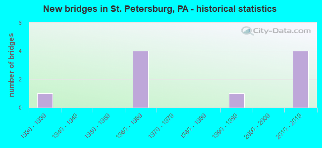
- New bridges - historical statistics
- 11930-1939
- 41960-1969
- 11990-1999
- 42010-2019


- Bridge Condition - Deck
- 20.0%Very good
- 20.0%Good
- 40.0%Satisfactory
- 20.0%Fair

- Bridge Condition - Superstructure
- 40.0%Very good
- 20.0%Good
- 20.0%Satisfactory
- 20.0%Fair

- Bridge Condition - Substructure
- 20.0%Very good
- 40.0%Good
- 20.0%Satisfactory
- 20.0%Fair

- Bridge Condition - Channel
- 50.0%Satisfactory
- 50.0%Fair
Find on map >> Show street view
Structure Number: 10901, Location: ALUM ROCK NO.1 (Lat: 41.165969, Lng: -79.620872), Route carried "on" structure: State highway 58, Year Built: 1991, Status: Open, Structure Length: 1.71m (5.61ft), Average Daily Traffic: 550 (year 2021), Truck Traffic: 4%, Average Future Daily Traffic: 724 (year 2032), Design Load: HS 25 or greater, Features Intersected: TURKEY RUN
Minimum Vertical Clearance: 30+ m (98+ ft), Kilometerpoint: 6.170, Lanes on structure: 2, Owner: State Highway Agency, Approaching Roadway Width: 9.8m (32.2ft), Skew: 2 degrees, Material/Design: Prestressed concrete, Design/Construction: Box Beam or Girders - Single/Spread, Number Of Spans In Main Unit: 1, Length of Maximum Span: 16.8m (55.1ft), Curb or Sidewalk Widths: Left: 0.2m (0.7ft), Right: 0.2m (0.7ft), Curb-To-Curb Width: 9.9m (32.5ft), Out-to-Out Width: 11.1m (36.4ft)
Condition: Deck: Satisfactory, Superstructure: Good, Substructure: Good, Channel: Fair, Operating Rating: 89.8 metric tons, Method Used To Determine Operating Rating: Load Factor (LF), Inventory Rating: 39.9 metric tons, Method Used To Determine Inventory Rating: Load Factor (LF), Structural Evaluation: Better than present minimum criteria, Deck Geometry: Equal to present minimum criteria, Waterway Adequacy: Equal to present desirable criteria, Approach Roadway Alignment: Somewhat better than minimum adequacy, Length Of Structure Improvement: 2.40m (7.87ft), Designated Inspection Frequency: Every 48 months, Inspection Date: May 2019, Deck Structure Type: Concrete Cast-file-Place, Wearing Surface/Protective System: Wearing Surface: Monolithic Concrete, Deck Protection: Epoxy Coated Reinforcing
Find on map >> Show street view
Structure Number: 10936, Location: TURKEY RUN (Lat: 41.191083, Lng: -79.613081), Route carried "on" structure: Interstate 80, Year Built: 1966, Status: Open, Structure Length: 1.25m (4.10ft), Average Daily Traffic: 24,036 (year 2022), Truck Traffic: 41%, Average Future Daily Traffic: 28,679 (year 2032), Design Load: HS 20+Mod, Features Intersected: TURKEY RUN
Minimum Vertical Clearance: 30+ m (98+ ft), Kilometerpoint: 7.443, Lanes on structure: 2, Base Highway Network: Yes, Owner: State Highway Agency, Approaching Roadway Width: 23.2m (76.1ft), Skew: 21 degrees, Material/Design: Concrete, Design/Construction: Culvert, Number Of Spans In Main Unit: 1, Length of Maximum Span: 12.5m (41.0ft)
Condition: Channel: Satisfactory, Culverts: Fair, Operating Rating: 49.0 metric tons, Method Used To Determine Operating Rating: Field evaluation and documented engineering judgment, Inventory Rating: 32.7 metric tons, Method Used To Determine Inventory Rating: Field evaluation and documented engineering judgment, Structural Evaluation: Somewhat better than minimum adequacy, Waterway Adequacy: Superior to present desirable criteria, Approach Roadway Alignment: Equal to present desirable criteria, Length Of Structure Improvement: 1.90m (6.23ft), Designated Inspection Frequency: Every 24 months, Inspection Date: April 2021, Bridge Improvement Cost: $67,000, Roadway Improvement Cost: $196,000, Total Project Cost: $900,000
Find on map >> Show street view
Structure Number: 10938, Location: TURKEY WB (Lat: 41.190475, Lng: -79.611475), Route carried "on" structure: Interstate 80, Year Built: 1966, Status: Open, Structure Length: 3.08m (10.10ft), Average Daily Traffic: 12,519 (year 2022), Truck Traffic: 37%, Average Future Daily Traffic: 14,384 (year 2032), Design Load: HS 20+Mod, Features Intersected: SR0338
Minimum Vertical Clearance: 30+ m (98+ ft), Kilometerpoint: 8.319, Lanes on structure: 2, Lanes under structure: 2, Base Highway Network: Yes, Owner: State Highway Agency, Approaching Roadway Width: 11.6m (38.1ft), Skew: 10 degrees, Material/Design: Prestressed concrete continuous, Design/Construction: Box Beam or Girders - Single/Spread, Number Of Spans In Main Unit: 3, Length of Maximum Span: 12.5m (41.0ft), Curb or Sidewalk Widths: Left: 0.2m (0.7ft), Right: 0.2m (0.7ft), Curb-To-Curb Width: 12.8m (42.0ft), Out-to-Out Width: 13.9m (45.6ft)
Condition: Deck: Fair, Superstructure: Fair, Substructure: Satisfactory, Operating Rating: 40.8 metric tons, Method Used To Determine Operating Rating: Load Factor (LF), Inventory Rating: 24.5 metric tons, Method Used To Determine Inventory Rating: Load Factor (LF), Structural Evaluation: Somewhat better than minimum adequacy, Deck Geometry: Equal to present desirable criteria, Underclear: High priority of corrective action, Approach Roadway Alignment: Equal to present desirable criteria, Length Of Structure Improvement: 3.80m (12.47ft), Designated Inspection Frequency: Every 24 months, Inspection Date: May 2021, Bridge Improvement Cost: $13,000, Roadway Improvement Cost: $37,000, Total Project Cost: $171,000, Deck Structure Type: Concrete Cast-file-Place, Wearing Surface/Protective System: Wearing Surface: Epoxy Overlay, Membrane: Epoxy
Find on map >> Show street view
Structure Number: 11077, Location: SALEM ROAD (Lat: 41.196414, Lng: -79.613314), Route carried "on" structure: State highway , Year Built: 1939, Year Reconstructed: 2002, Status: Open, Structure Length: 0.98m (3.22ft), Average Daily Traffic: 259 (year 2020), Truck Traffic: 15%, Average Future Daily Traffic: 143 (year 2032), Design Load: HS 25 or greater, Features Intersected: TURKEY RUN, Facility Carried by Structure: SR4003
Minimum Vertical Clearance: 30+ m (98+ ft), Kilometerpoint: 0.000, Lanes on structure: 2, Owner: State Highway Agency, Approaching Roadway Width: 4.9m (16.1ft), Material/Design: Concrete, Design/Construction: Channel Beam, Number Of Spans In Main Unit: 1, Length of Maximum Span: 9.1m (29.9ft), Curb or Sidewalk Widths: Left: 0.2m (0.7ft), Right: 0.2m (0.7ft), Curb-To-Curb Width: 7.9m (25.9ft), Out-to-Out Width: 9.3m (30.5ft)
Condition: Deck: Satisfactory, Superstructure: Satisfactory, Substructure: Fair, Channel: Fair, Operating Rating: 89.8 metric tons, Method Used To Determine Operating Rating: Load Factor (LF), Inventory Rating: 59.0 metric tons, Method Used To Determine Inventory Rating: Load Factor (LF), Structural Evaluation: Somewhat better than minimum adequacy, Deck Geometry: Somewhat better than minimum adequacy, Waterway Adequacy: Equal to present desirable criteria, Approach Roadway Alignment: Somewhat better than minimum adequacy, Length Of Structure Improvement: 1.01m (3.31ft), Designated Inspection Frequency: Every 24 months, Inspection Date: May 2021, Deck Structure Type: Concrete Cast-file-Place, Wearing Surface/Protective System: Wearing Surface: Bituminous, Membrane: Preformed Fabric, Deck Protection: Epoxy Coated Reinforcing
Find on map >> Show street view
Structure Number: 54503, Location: 75Ft NW SR 338 Inter. (Lat: 41.167333, Lng: -79.621556), Route carried "on" structure: State highway , Year Built: 2017, Status: Open, Structure Length: 1.80m (5.91ft), Average Daily Traffic: 49 (year 2021), Truck Traffic: 8%, Average Future Daily Traffic: 60 (year 2032), Design Load: HL 93, Features Intersected: TURKEY RUN, Facility Carried by Structure: SR 3020
Minimum Vertical Clearance: 30+ m (98+ ft), Kilometerpoint: 5.736, Lanes on structure: 2, Owner: State Highway Agency, Approaching Roadway Width: 9.1m (29.9ft), Material/Design: Steel, Design/Construction: Stringer/Multi-beam, Number Of Spans In Main Unit: 1, Length of Maximum Span: 17.1m (56.1ft), Curb or Sidewalk Widths: Left: 0.2m (0.7ft), Right: 0.2m (0.7ft), Curb-To-Curb Width: 8.5m (27.9ft), Out-to-Out Width: 9.6m (31.5ft)
Condition: Deck: Good, Superstructure: Very good, Substructure: Very good, Channel: Satisfactory, Operating Rating: 55.7 metric tons, Method Used To Determine Operating Rating: Assigned ratings based on Load and Resistance Factor Design (LRFD) reported by rating factor (RF) using HL93 loadings, Inventory Rating: 43.1 metric tons, Method Used To Determine Inventory Rating: Assigned ratings based on Load and Resistance Factor Design (LRFD) reported by rating factor (RF) using HL93 loadings, Structural Evaluation: Equal to present desirable criteria, Deck Geometry: Better than present minimum criteria, Waterway Adequacy: Superior to present desirable criteria, Approach Roadway Alignment: Equal to present desirable criteria, Designated Inspection Frequency: Every 48 months, Inspection Date: June 2021, Deck Structure Type: Concrete Cast-file-Place, Wearing Surface/Protective System: Wearing Surface: Monolithic Concrete, Deck Protection: Epoxy Coated Reinforcing
Find on map >> Show street view
Structure Number: 55979, Location: 2.3 mi N SR 338 Intersect (Lat: 41.192708, Lng: -79.643528), Route carried "on" structure: State highway , Year Built: 2018, Status: Open, Structure Length: 7.68m (25.20ft), Average Daily Traffic: 49 (year 2021), Truck Traffic: 8%, Average Future Daily Traffic: 60 (year 2032), Design Load: HL 93, Features Intersected: SR 0080 EB & WB, Facility Carried by Structure: SR 3020, MASTER RD
Minimum Vertical Clearance: 30+ m (98+ ft), Kilometerpoint: 2.483, Lanes on structure: 2, Lanes under structure: 4, Owner: State Highway Agency, Approaching Roadway Width: 8.2m (26.9ft), Skew: 2 degrees, Material/Design: Steel continuous, Design/Construction: Stringer/Multi-beam, Number Of Spans In Main Unit: 2, Length of Maximum Span: 38.1m (125.0ft), Curb or Sidewalk Widths: Left: 0.2m (0.7ft), Right: 0.2m (0.7ft), Curb-To-Curb Width: 8.5m (27.9ft), Out-to-Out Width: 9.6m (31.5ft)
Condition: Deck: Very good, Superstructure: Very good, Substructure: Good, Operating Rating: 62.5 metric tons, Method Used To Determine Operating Rating: Assigned ratings based on Load and Resistance Factor Design (LRFD) reported by rating factor (RF) using HL93 loadings, Inventory Rating: 48.3 metric tons, Method Used To Determine Inventory Rating: Assigned ratings based on Load and Resistance Factor Design (LRFD) reported by rating factor (RF) using HL93 loadings, Structural Evaluation: Better than present minimum criteria, Deck Geometry: Better than present minimum criteria, Underclear: Somewhat better than minimum adequacy, Approach Roadway Alignment: Better than present minimum criteria, Designated Inspection Frequency: Every 24 months, Inspection Date: October 2020, Deck Structure Type: Concrete Cast-file-Place, Wearing Surface/Protective System: Wearing Surface: Monolithic Concrete, Deck Protection: Epoxy Coated Reinforcing
Find on map >> Show street view
Structure Number: 10937, Location: TURKEY EB (Lat: 41.190281, Lng: -79.611781), Route carried "under" structure: State highway 338, Year Built: 1966, Structure Length: 0. m, Average Daily Traffic: 312 (year 2022), Truck Traffic: 7%, Features Intersected: SR0338, Facility Carried by Structure: SR0080 EB
Minimum Vertical Clearance: 5.54m (18.18ft), Kilometerpoint: 2.892, Lanes on structure: 2, Lanes under structure: 2, Material/Design: Prestressed concrete continuous, Design/Construction: Box Beam or Girders - Single/Spread, Length of Maximum Span: 13.1m (43.0ft)
Find on map >> Show street view
Structure Number: 10938, Location: TURKEY WB (Lat: 41.190475, Lng: -79.611475), Route carried "under" structure: State highway 338, Year Built: 1966, Structure Length: 0. m, Average Daily Traffic: 312 (year 2022), Truck Traffic: 7%, Features Intersected: SR0338, Facility Carried by Structure: SR0080 WB
Minimum Vertical Clearance: 4.71m (15.45ft), Kilometerpoint: 2.892, Lanes on structure: 2, Lanes under structure: 2, Material/Design: Prestressed concrete continuous, Design/Construction: Box Beam or Girders - Single/Spread, Length of Maximum Span: 12.5m (41.0ft)
Find on map >> Show street view
Structure Number: 55979, Location: 2.3 mi N SR 338 Intersect (Lat: 41.192708, Lng: -79.643528), Route carried "under" structure: Interstate 80, Year Built: 2018, Structure Length: 0. m, Average Daily Traffic: 11,517 (year 2022), Truck Traffic: 46%, Features Intersected: SR 0080 EB & WB, Facility Carried by Structure: SR 3020, MASTER RD
Minimum Vertical Clearance: 5.31m (17.42ft), Kilometerpoint: 5.176, Lanes on structure: 2, Lanes under structure: 2, Material/Design: Steel continuous, Design/Construction: Stringer/Multi-beam, Length of Maximum Span: 38.1m (125.0ft)
Find on map >> Show street view
Structure Number: 55979, Location: 2.3 mi N SR 338 Intersect (Lat: 41.192708, Lng: -79.643528), Route carried "under" structure: Interstate 80, Year Built: 2018, Structure Length: 0. m, Average Daily Traffic: 12,519 (year 2022), Truck Traffic: 37%, Features Intersected: SR 0080 EB & WB, Facility Carried by Structure: SR 3020, MASTER RD
Minimum Vertical Clearance: 6.00m (19.69ft), Kilometerpoint: 5.131, Lanes on structure: 2, Lanes under structure: 2, Material/Design: Steel continuous, Design/Construction: Stringer/Multi-beam, Length of Maximum Span: 38.1m (125.0ft)