Bridge Statistics for St. Michael, Pennsylvania (PA)
Condition, Traffic, Stress, Structural Evaluation, Project Costs
- National Bridge Inventory (NBI) Statistics
- 12Number of bridges
- 52ft / 15.8mTotal length
- $3,218,000Total costs
- 81,922Total average daily traffic
- 6,421Total average daily truck traffic
- National Bridge Inventory (NBI) Registered Bridges for St. Michael
- No street view available for this location
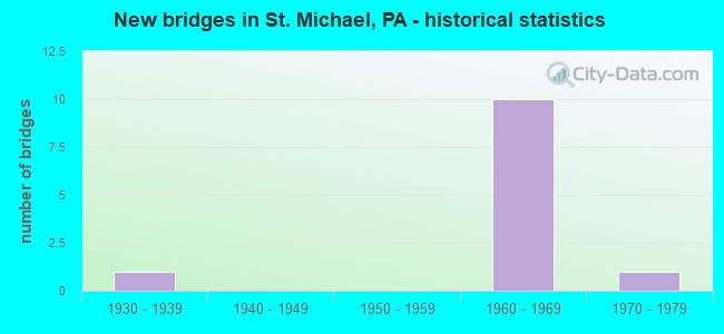
- New bridges - historical statistics
- 11930-1939
- 101960-1969
- 11970-1979

- Reconstructed bridges - Historical Statistics
- 12000-2009
- 32010-2019


- Bridge Condition - Deck
- 25.0%Good
- 50.0%Satisfactory
- 25.0%Fair

- Bridge Condition - Superstructure
- 20.0%Very good
- 20.0%Good
- 40.0%Satisfactory
- 20.0%Fair

- Bridge Condition - Substructure
- 20.0%Good
- 80.0%Satisfactory

- Bridge Condition - Channel
- 33.3%Good
- 33.3%Satisfactory
- 33.3%Fair
Find on map >> Show street view
Structure Number: 8454, Location: 0.7 MILE SOUTH OF TR 869 (Lat: 40.336642, Lng: -78.788464), Route carried "on" structure: US 219, Year Built: 1965, Status: Open, Structure Length: 1.58m (5.18ft), Average Daily Traffic: 19,616 (year 2021), Truck Traffic: 9%, Average Future Daily Traffic: 24,270 (year 2032), Design Load: HS 20, Features Intersected: SANDY RUN
Minimum Vertical Clearance: 30+ m (98+ ft), Kilometerpoint: 13.007, Lanes on structure: 2, Base Highway Network: Yes, Owner: State Highway Agency, Approaching Roadway Width: 37.8m (124.0ft), Skew: 24 degrees, Material/Design: Concrete, Design/Construction: Culvert, Number Of Spans In Main Unit: 2, Length of Maximum Span: 5.5m (18.0ft)
Condition: Channel: Fair, Culverts: Satisfactory, Inventory Rating: 70.8 metric tons, Method Used To Determine Inventory Rating: Load Factor (LF), Structural Evaluation: Equal to present minimum criteria, Waterway Adequacy: Superior to present desirable criteria, Approach Roadway Alignment: Equal to present desirable criteria, Length Of Structure Improvement: 2.00m (6.56ft), Designated Inspection Frequency: Every 48 months, Inspection Date: Febuary 2019, Bridge Improvement Cost: $58,000, Roadway Improvement Cost: $264,000, Total Project Cost: $785,000
Find on map >> Show street view
Structure Number: 8455, Location: 0.4 MILE SOUTH OF TR 869 (Lat: 40.338578, Lng: -78.784303), Route carried "on" structure: US 219, Year Built: 1965, Year Reconstructed: 2010, Status: Open, Structure Length: 1.37m (4.49ft), Average Daily Traffic: 19,616 (year 2021), Truck Traffic: 9%, Average Future Daily Traffic: 24,270 (year 2032), Design Load: HS 20, Features Intersected: T316 PALESTINE ROAD
Minimum Vertical Clearance: 30+ m (98+ ft), Kilometerpoint: 13.734, Lanes on structure: 2, Lanes under structure: 2, Base Highway Network: Yes, Owner: State Highway Agency, Approaching Roadway Width: 11.6m (38.1ft), Skew: 31 degrees, Material/Design: Prestressed concrete, Design/Construction: Box Beam or Girders - Multiple, Number Of Spans In Main Unit: 1, Length of Maximum Span: 12.5m (41.0ft), Curb-To-Curb Width: 11.6m (38.1ft), Out-to-Out Width: 28.5m (93.5ft)
Condition: Superstructure: Satisfactory, Substructure: Satisfactory, Inventory Rating: 78.0 metric tons, Method Used To Determine Inventory Rating: Load Factor (LF), Structural Evaluation: Equal to present minimum criteria, Deck Geometry: Somewhat better than minimum adequacy, Underclear: Superior to present desirable criteria, Approach Roadway Alignment: Equal to present desirable criteria, Length Of Structure Improvement: 2.00m (6.56ft), Designated Inspection Frequency: Every 48 months, Inspection Date: August 2020, Deck Structure Type: Concrete Cast-file-Place, Wearing Surface/Protective System: Wearing Surface: Bituminous, Membrane: Preformed Fabric, Deck Protection: Epoxy Coated Reinforcing
Find on map >> Show street view
Structure Number: 8457, Location: OVER PA 869 (Lat: 40.344347, Lng: -78.780528), Route carried "on" structure: US 219, Year Built: 1965, Year Reconstructed: 2009, Status: Open, Structure Length: 7.01m (23.00ft), Average Daily Traffic: 15,540 (year 2022), Truck Traffic: 8%, Average Future Daily Traffic: 19,975 (year 2032), Design Load: HS 20, Features Intersected: PA 869 & SR 3048
Minimum Vertical Clearance: 30+ m (98+ ft), Kilometerpoint: 14.439, Lanes on structure: 3, Lanes under structure: 4, Base Highway Network: Yes, Owner: State Highway Agency, Approaching Roadway Width: 12.8m (42.0ft), Skew: 34 degrees, Material/Design: Prestressed concrete, Design/Construction: Stringer/Multi-beam, Number Of Spans In Main Unit: 3, Length of Maximum Span: 29.9m (98.1ft), Curb or Sidewalk Widths: Left: 0.2m (0.7ft), Right: 0.2m (0.7ft), Curb-To-Curb Width: 12.6m (41.3ft), Out-to-Out Width: 25.0m (82.0ft)
Condition: Deck: Satisfactory, Superstructure: Good, Substructure: Satisfactory, Operating Rating: 78.9 metric tons, Method Used To Determine Operating Rating: Load Factor (LF), Inventory Rating: 12.7 metric tons, Method Used To Determine Inventory Rating: Load Factor (LF), Structural Evaluation: High priority of corrective action, Deck Geometry: Meets minimum limits, Underclear: Meets minimum limits, Approach Roadway Alignment: Equal to present desirable criteria, Length Of Structure Improvement: 8.00m (26.25ft), Designated Inspection Frequency: Every 24 months, Inspection Date: June 2021, Bridge Improvement Cost: $128,000, Roadway Improvement Cost: $378,000, Total Project Cost: $1,733,000, Deck Structure Type: Concrete Cast-file-Place, Wearing Surface/Protective System: Wearing Surface: Latex Concrete
Find on map >> Show street view
Structure Number: 846, Location: 1.0 MILE NORTH OF TR 869 (Lat: 40.354728, Lng: -78.767681), Route carried "on" structure: US 219, Year Built: 1968, Year Reconstructed: 2010, Status: Open, Structure Length: 3.66m (12.01ft), Average Daily Traffic: 15,540 (year 2022), Truck Traffic: 8%, Average Future Daily Traffic: 19,975 (year 2032), Design Load: HS 20, Features Intersected: SR 2006
Minimum Vertical Clearance: 30+ m (98+ ft), Kilometerpoint: 16.087, Lanes on structure: 2, Lanes under structure: 2, Base Highway Network: Yes, Owner: State Highway Agency, Approaching Roadway Width: 11.6m (38.1ft), Skew: 31 degrees, Material/Design: Concrete continuous, Design/Construction: Slab, Number Of Spans In Main Unit: 3, Length of Maximum Span: 13.7m (44.9ft), Curb or Sidewalk Widths: Left: 0.2m (0.7ft), Right: 0.2m (0.7ft), Curb-To-Curb Width: 11.4m (37.4ft), Out-to-Out Width: 24.8m (81.4ft)
Condition: Deck: Satisfactory, Superstructure: Satisfactory, Substructure: Good, Operating Rating: 53.5 metric tons, Method Used To Determine Operating Rating: Load Factor (LF), Inventory Rating: 31.8 metric tons, Method Used To Determine Inventory Rating: Load Factor (LF), Structural Evaluation: Equal to present minimum criteria, Deck Geometry: Meets minimum limits, Underclear: Somewhat better than minimum adequacy, Approach Roadway Alignment: Equal to present desirable criteria, Length Of Structure Improvement: 4.50m (14.76ft), Designated Inspection Frequency: Every 24 months, Inspection Date: April 2021, Wearing Surface/Protective System: Wearing Surface: Latex Concrete
Find on map >> Show street view
Structure Number: 8719, Location: .7 MI.W.OF ST.MICHAEL (Lat: 40.338981, Lng: -78.784428), Route carried "on" structure: City street , Year Built: 1977, Status: Open, Structure Length: 1.01m (3.31ft), Average Daily Traffic: 250 (year 2021), Truck Traffic: 1%, Average Future Daily Traffic: 313 (year 2041), Design Load: HS 20, Features Intersected: SANDY RUN, Facility Carried by Structure: T-316,PALESTINE RD
Minimum Vertical Clearance: 30+ m (98+ ft), Kilometerpoint: 0.000, Lanes on structure: 2, Owner: Town or Township Highway Agency, Approaching Roadway Width: 5.2m (17.1ft), Material/Design: Prestressed concrete, Design/Construction: Box Beam or Girders - Multiple, Number Of Spans In Main Unit: 1, Length of Maximum Span: 9.4m (30.8ft), Curb-To-Curb Width: 6.9m (22.6ft), Out-to-Out Width: 7.4m (24.3ft)
Condition: Deck: Fair, Superstructure: Fair, Substructure: Satisfactory, Channel: Satisfactory, Operating Rating: 50.8 metric tons, Method Used To Determine Operating Rating: Load Factor (LF), Inventory Rating: 29.9 metric tons, Method Used To Determine Inventory Rating: Load Factor (LF), Structural Evaluation: Somewhat better than minimum adequacy, Deck Geometry: Meets minimum limits, Waterway Adequacy: Better than present minimum criteria, Approach Roadway Alignment: Equal to present desirable criteria, Length Of Structure Improvement: 1.60m (5.25ft), Designated Inspection Frequency: Every 24 months, Inspection Date: January 2021, Deck Structure Type: Other, Wearing Surface/Protective System: Wearing Surface: Bituminous
Find on map >> Show street view
Structure Number: 8722, Location: 1 MI.NW.OF ST.MICHAEL (Lat: 40.347797, Lng: -78.783119), Route carried "on" structure: City street , Year Built: 1936, Year Reconstructed: 2010, Status: Open, Structure Length: 1.19m (3.90ft), Average Daily Traffic: 75 (year 2020), Average Future Daily Traffic: 94 (year 2040), Design Load: HL 93, Features Intersected: SANDY RUN, Facility Carried by Structure: T-381, AMSITE ROAD
Minimum Vertical Clearance: 30+ m (98+ ft), Kilometerpoint: 0.000, Lanes on structure: 2, Owner: Town or Township Highway Agency, Approaching Roadway Width: 4.9m (16.1ft), Material/Design: Steel, Design/Construction: Stringer/Multi-beam, Number Of Spans In Main Unit: 1, Length of Maximum Span: 11.6m (38.1ft), Curb-To-Curb Width: 6.6m (21.7ft), Out-to-Out Width: 7.3m (24.0ft)
Condition: Deck: Good, Superstructure: Very good, Substructure: Satisfactory, Channel: Good, Operating Rating: 76.2 metric tons, Method Used To Determine Operating Rating: Load and Resistance Factor (LRFR), Inventory Rating: 58.1 metric tons, Method Used To Determine Inventory Rating: Load and Resistance Factor (LRFR), Structural Evaluation: Equal to present minimum criteria, Deck Geometry: Somewhat better than minimum adequacy, Waterway Adequacy: Better than present minimum criteria, Approach Roadway Alignment: Equal to present desirable criteria, Length Of Structure Improvement: 1.50m (4.92ft), Designated Inspection Frequency: Every 24 months, Inspection Date: November 2020, Bridge Improvement Cost: $52,000, Roadway Improvement Cost: $264,000, Total Project Cost: $700,000, Deck Structure Type: Concrete Cast-file-Place, Wearing Surface/Protective System: Wearing Surface: Monolithic Concrete, Deck Protection: Epoxy Coated Reinforcing
Find on map >> Show street view
Structure Number: 8455, Location: 0.4 MILE SOUTH OF TR 869 (Lat: 40.338578, Lng: -78.784303), Route carried "under" structure: City street , Year Built: 1965, Structure Length: 0. m, Average Daily Traffic: 100 (year 1984), Truck Traffic: 1%, Features Intersected: T316 PALESTINE ROAD, Facility Carried by Structure: US 219
Minimum Vertical Clearance: 5.28m (17.32ft), Kilometerpoint: 0.000, Lanes on structure: 2, Lanes under structure: 2, Material/Design: Prestressed concrete, Design/Construction: Box Beam or Girders - Multiple, Length of Maximum Span: 12.5m (41.0ft)
Find on map >> Show street view
Structure Number: 8457, Location: OVER PA 869 (Lat: 40.344347, Lng: -78.780528), Route carried "under" structure: State highway , Year Built: 1965, Structure Length: 0. m, Average Daily Traffic: 1,933 (year 2021), Truck Traffic: 6%, Features Intersected: PA 869 & SR 3048, Facility Carried by Structure: US 219
Minimum Vertical Clearance: 4.60m (15.09ft), Kilometerpoint: 0.000, Lanes on structure: 3, Lanes under structure: 2, Material/Design: Prestressed concrete, Design/Construction: Stringer/Multi-beam, Length of Maximum Span: 29.9m (98.1ft)
Find on map >> Show street view
Structure Number: 8457, Location: OVER PA 869 (Lat: 40.344347, Lng: -78.780528), Route carried "under" structure: State highway 869, Year Built: 1965, Structure Length: 0. m, Average Daily Traffic: 3,322 (year 2020), Truck Traffic: 2%, Features Intersected: PA 869 & SR 3048, Facility Carried by Structure: US 219
Minimum Vertical Clearance: 4.95m (16.24ft), Kilometerpoint: 0.000, Lanes on structure: 3, Lanes under structure: 2, Material/Design: Prestressed concrete, Design/Construction: Stringer/Multi-beam, Length of Maximum Span: 29.9m (98.1ft)
Find on map >> Show street view
Structure Number: 8457, Location: OVER PA 869 (Lat: 40.344347, Lng: -78.780528), Route carried "under" structure: State highway , Year Built: 1965, Structure Length: 0. m, Average Daily Traffic: 2,081 (year 2021), Truck Traffic: 6%, Features Intersected: PA 869 & SR 3048, Facility Carried by Structure: US 219
Minimum Vertical Clearance: 4.95m (16.24ft), Kilometerpoint: 0.000, Lanes on structure: 3, Lanes under structure: 2, Material/Design: Prestressed concrete, Design/Construction: Stringer/Multi-beam, Length of Maximum Span: 29.9m (98.1ft)
Find on map >> Show street view
Structure Number: 8457, Location: OVER PA 869 (Lat: 40.344347, Lng: -78.780528), Route carried "under" structure: State highway 869, Year Built: 1965, Structure Length: 0. m, Average Daily Traffic: 3,322 (year 2020), Truck Traffic: 2%, Features Intersected: PA 869 & SR 3048, Facility Carried by Structure: US 219
Minimum Vertical Clearance: 4.60m (15.09ft), Kilometerpoint: 0.000, Lanes on structure: 3, Lanes under structure: 2, Material/Design: Prestressed concrete, Design/Construction: Stringer/Multi-beam, Length of Maximum Span: 29.9m (98.1ft)
Find on map >> Show street view
Structure Number: 846, Location: 1.0 MILE NORTH OF TR 869 (Lat: 40.354728, Lng: -78.767681), Route carried "under" structure: State highway , Year Built: 1968, Structure Length: 0. m, Average Daily Traffic: 527 (year 2022), Truck Traffic: 6%, Features Intersected: SR 2006, Facility Carried by Structure: US 219
Minimum Vertical Clearance: 4.61m (15.12ft), Kilometerpoint: 1.276, Lanes on structure: 2, Lanes under structure: 2, Material/Design: Concrete continuous, Design/Construction: Slab, Length of Maximum Span: 13.7m (44.9ft)