Bridge Statistics for St. Marys, West Virginia (WV)
Condition, Traffic, Stress, Structural Evaluation, Project Costs
- National Bridge Inventory (NBI) Statistics
- 10Number of bridges
- 131ft / 39.8mTotal length
- $11,135,000Total costs
- 24,220Total average daily traffic
- 1,906Total average daily truck traffic
- National Bridge Inventory (NBI) Registered Bridges for St. Marys
- No street view available for this location
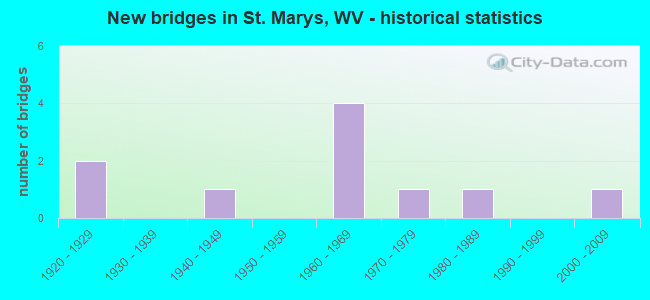
- New bridges - historical statistics
- 21920-1929
- 11940-1949
- 41960-1969
- 11970-1979
- 11980-1989
- 12000-2009

- Reconstructed bridges - Historical Statistics
- 11980-1989
- 01990-1999
- 12000-2009
- 02010-2019
- 12020-2022


- Bridge Condition - Deck
- 57.1%Good
- 28.6%Satisfactory
- 14.3%Poor

- Bridge Condition - Superstructure
- 71.4%Good
- 14.3%Fair
- 14.3%Poor

- Bridge Condition - Substructure
- 42.9%Good
- 28.6%Fair
- 14.3%Poor
- 14.3%Critical

- Bridge Condition - Channel
- 60.0%Good
- 40.0%Satisfactory
Find on map >> Show street view
Structure Number: 37A006, Location: 0.08 MILE SOUTH OF CR 26 (Lat: 39.402589, Lng: -81.198181), Route carried "on" structure: State highway 2, Year Built: 1968, Year Reconstructed: 1993, Status: Open, Structure Length: 12.36m (40.55ft), Average Daily Traffic: 11,700 (year 2018), Truck Traffic: 8%, Average Future Daily Traffic: 14,625 (year 2038), Design Load: HS 20, Features Intersected: Middle Island Creek
Minimum Vertical Clearance: 30+ m (98+ ft), Kilometerpoint: 17.638, Lanes on structure: 4, Lanes under structure: 1, Base Highway Network: Yes, Owner: State Highway Agency, Approaching Roadway Width: 20.7m (67.9ft), Skew: 30 degrees, Material/Design: Steel continuous, Design/Construction: Girder and Floorbeam System, Number Of Spans In Main Unit: 1, Number Of Approach Spans: 2, Length of Maximum Span: 48.8m (160.1ft), Curb or Sidewalk Widths: Left: 0.4m (1.3ft), Right: 1.2m (3.9ft), Curb-To-Curb Width: 18.0m (59.1ft), Out-to-Out Width: 20.8m (68.2ft)
Condition: Deck: Satisfactory, Superstructure: Good, Substructure: Good, Channel: Good, Operating Rating: 72.6 metric tons, Method Used To Determine Operating Rating: Load Factor (LF), Inventory Rating: 43.5 metric tons, Method Used To Determine Inventory Rating: Load Factor (LF), Structural Evaluation: Better than present minimum criteria, Deck Geometry: Somewhat better than minimum adequacy, Underclear: High priority of replacement, Waterway Adequacy: Superior to present desirable criteria, Approach Roadway Alignment: Equal to present desirable criteria, Length Of Structure Improvement: 12.37m (40.58ft), Designated Inspection Frequency: Every 24 months, Critical Feature Inspection Frequency: Every 24 months, Underwater Inspection Frequency: Every 60 months, Inspection Date: August 2020, Critical Feature Inspection Date: August 2020, Underwater Inspection Date: September 2021, Bridge Improvement Cost: $5,000,000, Roadway Improvement Cost: $500,000, Total Project Cost: $5,500,000, Deck Structure Type: Concrete Cast-file-Place, Wearing Surface/Protective System: Wearing Surface: Integral Concrete, Deck Protection: Epoxy Coated Reinforcing
Find on map >> Show street view
Structure Number: 37A008, Location: 0.12 MI. W. OF CR. 28 (Lat: 39.390900, Lng: -81.133089), Route carried "on" structure: County highway 3, Year Built: 1976, Status: Open, Structure Length: 5.70m (18.70ft), Average Daily Traffic: 450 (year 2019), Truck Traffic: 4%, Average Future Daily Traffic: 644 (year 2039), Design Load: HS 20, Features Intersected: MCKIM CREEK
Minimum Vertical Clearance: 30+ m (98+ ft), Kilometerpoint: 7.017, Lanes on structure: 2, Owner: State Highway Agency, Approaching Roadway Width: 7.9m (25.9ft), Skew: 3 degrees, Material/Design: Steel continuous, Design/Construction: Stringer/Multi-beam, Number Of Spans In Main Unit: 1, Number Of Approach Spans: 2, Length of Maximum Span: 22.9m (75.1ft), Curb or Sidewalk Widths: Left: 0.3m (1.0ft), Right: 0.3m (1.0ft), Curb-To-Curb Width: 8.1m (26.6ft), Out-to-Out Width: 9.3m (30.5ft)
Condition: Deck: Good, Superstructure: Good, Substructure: Fair, Channel: Good, Operating Rating: 69.8 metric tons, Method Used To Determine Operating Rating: Load Factor (LF), Inventory Rating: 41.7 metric tons, Method Used To Determine Inventory Rating: Load Factor (LF), Structural Evaluation: Somewhat better than minimum adequacy, Deck Geometry: Somewhat better than minimum adequacy, Waterway Adequacy: Equal to present minimum criteria, Approach Roadway Alignment: Equal to present minimum criteria, Length Of Structure Improvement: 5.70m (18.70ft), Designated Inspection Frequency: Every 24 months, Underwater Inspection Frequency: Every 60 months, Inspection Date: June 2021, Underwater Inspection Date: August 2021, Bridge Improvement Cost: $184,000, Roadway Improvement Cost: $1,000, Total Project Cost: $185,000, Deck Structure Type: Concrete Cast-file-Place, Wearing Surface/Protective System: Wearing Surface: Monolithic Concrete
Find on map >> Show street view
Structure Number: 37A019, Location: 0.02 MI SOUTH OF CR 20 (Lat: 39.348469, Lng: -81.188439), Route carried "on" structure: County highway 22, Year Built: 1940, Year Reconstructed: 2008, Status: Open, Structure Length: 1.79m (5.87ft), Average Daily Traffic: 60 (year 2019), Average Future Daily Traffic: 70 (year 2039), Features Intersected: LEFT FORK FRENCH CREEK
Minimum Vertical Clearance: 30+ m (98+ ft), Kilometerpoint: 0.032, Lanes on structure: 2, Owner: State Highway Agency, Approaching Roadway Width: 5.5m (18.0ft), Material/Design: Steel continuous, Design/Construction: Stringer/Multi-beam, Number Of Spans In Main Unit: 2, Length of Maximum Span: 8.9m (29.2ft), Curb-To-Curb Width: 5.5m (18.0ft), Out-to-Out Width: 5.5m (18.0ft)
Condition: Deck: Good, Superstructure: Fair, Substructure: Poor, Channel: Satisfactory, Operating Rating: 68.9 metric tons, Method Used To Determine Operating Rating: Load Factor (LF), Inventory Rating: 41.7 metric tons, Method Used To Determine Inventory Rating: Load Factor (LF), Structural Evaluation: Meets minimum limits, Deck Geometry: Meets minimum limits, Waterway Adequacy: Equal to present minimum criteria, Approach Roadway Alignment: Equal to present minimum criteria, Length Of Structure Improvement: 1.83m (6.00ft), Designated Inspection Frequency: Every 24 months, Critical Feature Inspection Frequency: Every 24 months, Inspection Date: May 2021, Critical Feature Inspection Date: May 2021, Bridge Improvement Cost: $700,000, Roadway Improvement Cost: $50,000, Total Project Cost: $750,000, Deck Structure Type: Corrugated Steel, Wearing Surface/Protective System: Wearing Surface: Bituminous
Find on map >> Show street view
Structure Number: 37A027, Location: 0.17 MILE WEST OF WV 2 (Lat: 39.391000, Lng: -81.208581), Route carried "on" structure: County highway 210, Year Built: 1928, Year Reconstructed: 2020, Status: Open, Structure Length: 13.59m (44.59ft), Average Daily Traffic: 550 (year 2019), Average Future Daily Traffic: 787 (year 2039), Design Load: H 15, Features Intersected: OHIO RIVER BACK CHANNEL, Facility Carried by Structure: COUNTY ROUTE 2/10
Minimum Vertical Clearance: 5.87m (19.26ft), Kilometerpoint: 0.274, Lanes on structure: 2, Owner: State Highway Agency, Approaching Roadway Width: 6.1m (20.0ft), Navigation Control: Yes ( Vertical Clearance: 8.8m (28.9ft), Horizontal Clearance: 62.8m (206.0ft)), Material/Design: Steel, Design/Construction: Truss - Thru, Number Of Spans In Main Unit: 1, Number Of Approach Spans: 3, Length of Maximum Span: 65.1m (213.6ft), Curb or Sidewalk Widths: Left: 0.5m (1.6ft), Right: 1.5m (4.9ft), Curb-To-Curb Width: 6.1m (20.0ft), Out-to-Out Width: 9.0m (29.5ft)
Condition: Deck: Good, Superstructure: Good, Substructure: Good, Channel: Good, Operating Rating: 56.2 metric tons, Method Used To Determine Operating Rating: Load Factor (LF), Inventory Rating: 33.6 metric tons, Method Used To Determine Inventory Rating: Load Factor (LF), Structural Evaluation: Better than present minimum criteria, Deck Geometry: High priority of corrective action, Waterway Adequacy: Equal to present desirable criteria, Approach Roadway Alignment: Somewhat better than minimum adequacy, Length Of Structure Improvement: 24.38m (79.99ft), Designated Inspection Frequency: Every 24 months, Critical Feature Inspection Frequency: Every 24 months, Underwater Inspection Frequency: Every 60 months, Inspection Date: October 2021, Critical Feature Inspection Date: October 2021, Underwater Inspection Date: September 2021, Bridge Improvement Cost: $500,000, Roadway Improvement Cost: $500,000, Total Project Cost: $1,300,000, Deck Structure Type: Concrete Cast-file-Place, Wearing Surface/Protective System: Wearing Surface: Monolithic Concrete, Deck Protection: Epoxy Coated Reinforcing
Find on map >> Show street view
Structure Number: 37A032, Location: 0.13 MILE N OF WV 807 (Lat: 39.386089, Lng: -81.209139), Route carried "on" structure: State highway 2, Year Built: 2001, Status: Open, Structure Length: 2.23m (7.32ft), Average Daily Traffic: 8,900 (year 2019), Truck Traffic: 8%, Average Future Daily Traffic: 11,125 (year 2039), Design Load: HS 25 or greater, Features Intersected: CSX RAILROAD TRACKS
Minimum Vertical Clearance: 30+ m (98+ ft), Kilometerpoint: 15.498, Lanes on structure: 5, Base Highway Network: Yes, Owner: State Highway Agency, Approaching Roadway Width: 22.6m (74.1ft), Skew: 5 degrees, Material/Design: Prestressed concrete, Design/Construction: Stringer/Multi-beam, Number Of Spans In Main Unit: 1, Length of Maximum Span: 21.3m (69.9ft), Curb or Sidewalk Widths: Left: 1.5m (4.9ft), Right: 0.0m, Curb-To-Curb Width: 22.6m (74.1ft), Out-to-Out Width: 25.0m (82.0ft)
Condition: Deck: Satisfactory, Superstructure: Good, Substructure: Good, Operating Rating: 56.2 metric tons, Method Used To Determine Operating Rating: Load Factor (LF), Inventory Rating: 33.6 metric tons, Method Used To Determine Inventory Rating: Load Factor (LF), Structural Evaluation: Better than present minimum criteria, Deck Geometry: Equal to present minimum criteria, Underclear: Meets minimum limits, Approach Roadway Alignment: Equal to present desirable criteria, Length Of Structure Improvement: 2.23m (7.32ft), Designated Inspection Frequency: Every 48 months, Inspection Date: June 2021, Bridge Improvement Cost: $750,000, Roadway Improvement Cost: $250,000, Total Project Cost: $1,000,000, Deck Structure Type: Concrete Cast-file-Place, Wearing Surface/Protective System: Wearing Surface: Integral Concrete, Deck Protection: Epoxy Coated Reinforcing
Find on map >> Show street view
Structure Number: 37A901, Location: 0.07 MILE WEST OF WV 2 (Lat: 39.386961, Lng: -81.210000), Route carried "on" structure: City street N1425, Year Built: 1980, Status: Open, Structure Length: 2.49m (8.17ft), Average Daily Traffic: 50 (year 2018), Average Future Daily Traffic: 50 (year 2038), Features Intersected: CSX RAILROAD TRACK, Facility Carried by Structure: CITY STREET
Minimum Vertical Clearance: 30+ m (98+ ft), Kilometerpoint: 0.016, Lanes on structure: 1, Owner: City or Municipal Highway Agency, Approaching Roadway Width: 6.1m (20.0ft), Material/Design: Wood or Timber, Design/Construction: Stringer/Multi-beam, Number Of Spans In Main Unit: 1, Number Of Approach Spans: 2, Length of Maximum Span: 8.3m (27.2ft), Curb or Sidewalk Widths: Left: 0.2m (0.7ft), Right: 0.2m (0.7ft), Curb-To-Curb Width: 3.0m (9.8ft), Out-to-Out Width: 3.7m (12.1ft)
Condition: Deck: Good, Superstructure: Good, Substructure: Critical, Operating Rating: 3.6 metric tons, Method Used To Determine Operating Rating: Field evaluation and documented engineering judgment, Inventory Rating: 1.8 metric tons, Method Used To Determine Inventory Rating: Field evaluation and documented engineering judgment, Structural Evaluation: High priority of replacement, Deck Geometry: High priority of replacement, Underclear: High priority of replacement, Approach Roadway Alignment: High priority of corrective action, Bridge Posting: Required (Relationship of Operating Rating to Maximum Legal Load: > 39.9% below), Length Of Structure Improvement: 2.44m (8.01ft), Designated Inspection Frequency: Every 24 months, Inspection Date: May 2020, Bridge Improvement Cost: $1,100,000, Roadway Improvement Cost: $550,000, Total Project Cost: $1,650,000, Deck Structure Type: Wood or Timber, Wearing Surface/Protective System: Wearing Surface: Wood or Timber
Find on map >> Show street view
Structure Number: 54A058, Location: 0.08 MI. S. OF CR 21/25 (Lat: 39.412000, Lng: -81.195900), Route carried "on" structure: County highway 21, Year Built: 1922, Status: Open, Structure Length: 1.62m (5.31ft), Average Daily Traffic: 2,000 (year 2018), Truck Traffic: 10%, Average Future Daily Traffic: 2,080 (year 2038), Design Load: H 15, Features Intersected: TYGART CREEK
Minimum Vertical Clearance: 30+ m (98+ ft), Kilometerpoint: 8.497, Lanes on structure: 2, Owner: State Highway Agency, Approaching Roadway Width: 9.1m (29.9ft), Material/Design: Concrete, Design/Construction: Tee Beam, Number Of Spans In Main Unit: 1, Length of Maximum Span: 15.2m (49.9ft), Curb or Sidewalk Widths: Left: 0.2m (0.7ft), Right: 0.2m (0.7ft), Curb-To-Curb Width: 8.5m (27.9ft), Out-to-Out Width: 9.2m (30.2ft)
Condition: Deck: Poor, Superstructure: Poor, Substructure: Fair, Channel: Satisfactory, Operating Rating: 39.0 metric tons, Method Used To Determine Operating Rating: Load Factor (LF), Inventory Rating: 23.6 metric tons, Method Used To Determine Inventory Rating: Load Factor (LF), Structural Evaluation: Meets minimum limits, Deck Geometry: Somewhat better than minimum adequacy, Waterway Adequacy: Equal to present desirable criteria, Approach Roadway Alignment: Equal to present desirable criteria, Length Of Structure Improvement: 2.29m (7.51ft), Designated Inspection Frequency: Every 24 months, Inspection Date: December 2020, Bridge Improvement Cost: $450,000, Roadway Improvement Cost: $300,000, Total Project Cost: $750,000, Deck Structure Type: Concrete Cast-file-Place, Wearing Surface/Protective System: Wearing Surface: Bituminous
Find on map >> Show street view
Structure Number: 37A006, Location: 0.08 MILE SOUTH OF CR 26 (Lat: 39.402589, Lng: -81.198181), Route carried "under" structure: ServiceOther road , Year Built: 1968, Structure Length: 0. m, Average Daily Traffic: 10 (year 0007), Features Intersected: Middle Island Creek, Facility Carried by Structure: WEST VIRGINIA 2
Minimum Vertical Clearance: 6.99m (22.93ft), Kilometerpoint: 0.000, Lanes on structure: 4, Lanes under structure: 1, Length of Maximum Span: 48.8m (160.1ft)
Find on map >> Show street view
Structure Number: 54A121, Location: 4.88 MI S OF WV 14 (Lat: 39.423000, Lng: -81.193700), Route carried "under" structure: County highway 2124, Year Built: 1967, Structure Length: 0. m, Average Daily Traffic: 250 (year 0007), Truck Traffic: 8%, Features Intersected: CR 21/24, Facility Carried by Structure: I-77 NBL
Minimum Vertical Clearance: 4.52m (14.83ft), Kilometerpoint: 4.876, Lanes on structure: 2, Lanes under structure: 2, Length of Maximum Span: 15.9m (52.2ft)
Find on map >> Show street view
Structure Number: 54A122, Location: 4.88 MI S OF WV 14 (Lat: 39.423000, Lng: -81.193700), Route carried "under" structure: County highway 2124, Year Built: 1968, Structure Length: 0. m, Average Daily Traffic: 250 (year 0007), Truck Traffic: 8%, Features Intersected: CR 21/24, Facility Carried by Structure: I-77 SBL
Minimum Vertical Clearance: 4.52m (14.83ft), Kilometerpoint: 4.876, Lanes on structure: 2, Lanes under structure: 2, Length of Maximum Span: 14.8m (48.6ft)