Bridge Statistics for St. Joseph, Minnesota (MN)
Condition, Traffic, Stress, Structural Evaluation, Project Costs
- National Bridge Inventory (NBI) Statistics
- 23Number of bridges
- 305ft / 92.8mTotal length
- $952,000,000Total costs
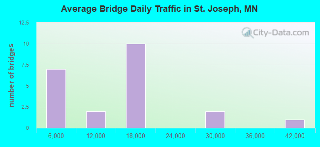
- 244,366Total average daily traffic
- 30,053Total average daily truck traffic
- National Bridge Inventory (NBI) Registered Bridges for St. Joseph
- No street view available for this location
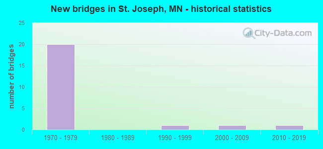
- New bridges - historical statistics
- 201970-1979
- 11990-1999
- 12000-2009
- 12010-2019
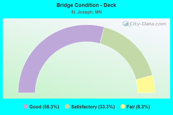
- Bridge Condition - Deck
- 58.3%Good
- 33.3%Satisfactory
- 8.3%Fair
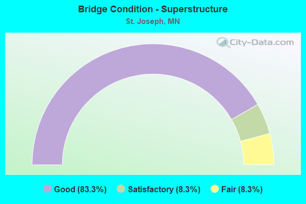
- Bridge Condition - Superstructure
- 83.3%Good
- 8.3%Satisfactory
- 8.3%Fair
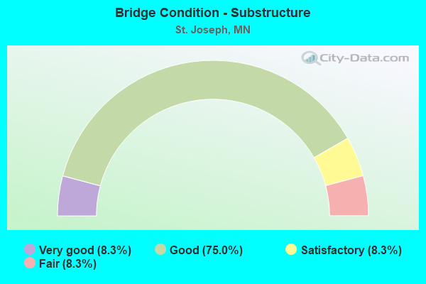
- Bridge Condition - Substructure
- 8.3%Very good
- 75.0%Good
- 8.3%Satisfactory
- 8.3%Fair
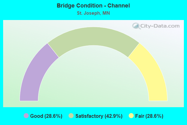
- Bridge Condition - Channel
- 28.6%Good
- 42.9%Satisfactory
- 28.6%Fair
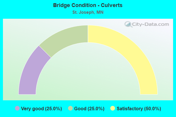
- Bridge Condition - Culverts
- 25.0%Very good
- 25.0%Good
- 50.0%Satisfactory
Find on map >> Show street view
Structure Number: 73561, Location: 0.3 MI N OF JCT CR 138 (Lat: 45.537289, Lng: -94.297539), Route carried "on" structure: County highway 121, Year Built: 2000, Status: Open, Structure Length: 5.54m (18.18ft), Average Daily Traffic: 2,100 (year 2017), Average Future Daily Traffic: 2,100 (year 2039), Design Load: HS 25 or greater, Features Intersected: SAUK RIVER
Minimum Vertical Clearance: 30+ m (98+ ft), Kilometerpoint: 0.000, Lanes on structure: 2, Owner: County Highway Agency, Approaching Roadway Width: 12.0m (39.4ft), Material/Design: Prestressed concrete, Design/Construction: Stringer/Multi-beam, Number Of Spans In Main Unit: 3, Length of Maximum Span: 21.4m (70.2ft), Curb or Sidewalk Widths: Left: 0.0m, Right: 1.8m (5.9ft), Curb-To-Curb Width: 12.0m (39.4ft), Out-to-Out Width: 14.9m (48.9ft)
Condition: Deck: Good, Superstructure: Good, Substructure: Very good, Channel: Good, Operating Rating: 68.1 metric tons, Method Used To Determine Operating Rating: Load Factor (LF), Inventory Rating: 41.3 metric tons, Method Used To Determine Inventory Rating: Load Factor (LF), Structural Evaluation: Better than present minimum criteria, Deck Geometry: Somewhat better than minimum adequacy, Waterway Adequacy: Superior to present desirable criteria, Approach Roadway Alignment: Equal to present desirable criteria, Designated Inspection Frequency: Every 24 months, Inspection Date: December 2020, Deck Structure Type: Concrete Cast-file-Place, Wearing Surface/Protective System: Wearing Surface: Monolithic Concrete, Deck Protection: Epoxy Coated Reinforcing
Find on map >> Show street view
Structure Number: 73864, Location: 1.0 MI NW OF JCT TH 23 (Lat: 45.524486, Lng: -94.300392), Route carried "on" structure: County highway 138, Year Built: 1976, Status: Open, Structure Length: 9.32m (30.58ft), Average Daily Traffic: 1,000 (year 2017), Average Future Daily Traffic: 1,000 (year 2039), Design Load: HS 20, Features Intersected: I 94
Minimum Vertical Clearance: 30+ m (98+ ft), Kilometerpoint: 0.000, Lanes on structure: 2, Lanes under structure: 4, Owner: State Highway Agency, Approaching Roadway Width: 11.0m (36.1ft), Skew: 1 degrees, Material/Design: Prestressed concrete, Design/Construction: Stringer/Multi-beam, Number Of Spans In Main Unit: 4, Length of Maximum Span: 27.9m (91.5ft), Curb-To-Curb Width: 11.0m (36.1ft), Out-to-Out Width: 12.1m (39.7ft)
Condition: Deck: Fair, Superstructure: Good, Substructure: Good, Operating Rating: 48.6 metric tons, Method Used To Determine Operating Rating: Load Factor (LF), Inventory Rating: 29.0 metric tons, Method Used To Determine Inventory Rating: Load Factor (LF), Structural Evaluation: Better than present minimum criteria, Deck Geometry: Better than present minimum criteria, Underclear: Equal to present minimum criteria, Approach Roadway Alignment: Equal to present desirable criteria, Designated Inspection Frequency: Every 24 months, Inspection Date: July 2020, Deck Structure Type: Concrete Cast-file-Place, Wearing Surface/Protective System: Wearing Surface: Monolithic Concrete
Find on map >> Show street view
Structure Number: 73865, Location: 1.6 MI NW OF JCT TH 23 (Lat: 45.529603, Lng: -94.309853), Route carried "on" structure: Interstate 94, Year Built: 1976, Status: Open, Structure Length: 9.12m (29.92ft), Average Daily Traffic: 12,750 (year 2019), Truck Traffic: 13%, Average Future Daily Traffic: 13,750 (year 2039), Design Load: HS 20+Mod, Features Intersected: SAUK RIVER
Minimum Vertical Clearance: 30+ m (98+ ft), Kilometerpoint: 0.000, Lanes on structure: 2, Base Highway Network: Yes, Owner: State Highway Agency, Approaching Roadway Width: 11.6m (38.1ft), Skew: 1 degrees, Material/Design: Prestressed concrete, Design/Construction: Stringer/Multi-beam, Number Of Spans In Main Unit: 3, Length of Maximum Span: 30.3m (99.4ft), Curb-To-Curb Width: 12.3m (40.4ft), Out-to-Out Width: 13.5m (44.3ft)
Condition: Deck: Good, Superstructure: Good, Substructure: Good, Channel: Fair, Operating Rating: 82.0 metric tons, Method Used To Determine Operating Rating: Load Factor (LF), Inventory Rating: 34.1 metric tons, Method Used To Determine Inventory Rating: Load Factor (LF), Structural Evaluation: Better than present minimum criteria, Deck Geometry: Better than present minimum criteria, Waterway Adequacy: Equal to present desirable criteria, Approach Roadway Alignment: Equal to present desirable criteria, Designated Inspection Frequency: Every 24 months, Inspection Date: July 2021, Deck Structure Type: Concrete Cast-file-Place, Wearing Surface/Protective System: Wearing Surface: Low Slump Concrete, Deck Protection: Galvanized Reinforcing
Find on map >> Show street view
Structure Number: 73866, Location: 1.6 MI NW OF JCT TH 23 (Lat: 45.529419, Lng: -94.310089), Route carried "on" structure: Interstate 94, Year Built: 1976, Status: Open, Structure Length: 9.12m (29.92ft), Average Daily Traffic: 12,750 (year 2019), Truck Traffic: 15%, Average Future Daily Traffic: 13,750 (year 2039), Design Load: HS 20+Mod, Features Intersected: SAUK RIVER
Minimum Vertical Clearance: 30+ m (98+ ft), Kilometerpoint: 0.000, Lanes on structure: 2, Base Highway Network: Yes, Owner: State Highway Agency, Approaching Roadway Width: 11.6m (38.1ft), Skew: 1 degrees, Material/Design: Prestressed concrete, Design/Construction: Stringer/Multi-beam, Number Of Spans In Main Unit: 3, Length of Maximum Span: 30.3m (99.4ft), Curb-To-Curb Width: 12.3m (40.4ft), Out-to-Out Width: 13.5m (44.3ft)
Condition: Deck: Good, Superstructure: Good, Substructure: Good, Channel: Fair, Operating Rating: 82.0 metric tons, Method Used To Determine Operating Rating: Load Factor (LF), Inventory Rating: 34.1 metric tons, Method Used To Determine Inventory Rating: Load Factor (LF), Structural Evaluation: Better than present minimum criteria, Deck Geometry: Better than present minimum criteria, Waterway Adequacy: Equal to present desirable criteria, Approach Roadway Alignment: Equal to present desirable criteria, Designated Inspection Frequency: Every 24 months, Inspection Date: July 2021, Deck Structure Type: Concrete Cast-file-Place, Wearing Surface/Protective System: Wearing Surface: Low Slump Concrete, Deck Protection: Galvanized Reinforcing
Find on map >> Show street view
Structure Number: 73868, Location: 6.0 MI NW OF JCT TH 23 (Lat: 45.583050, Lng: -94.358544), Route carried "on" structure: Interstate 94, Year Built: 1976, Status: Open, Structure Length: 9.15m (30.02ft), Average Daily Traffic: 12,750 (year 2017), Truck Traffic: 14%, Average Future Daily Traffic: 12,750 (year 2039), Design Load: HS 20+Mod, Features Intersected: CSAH 75 EB
Minimum Vertical Clearance: 30+ m (98+ ft), Kilometerpoint: 0.000, Lanes on structure: 2, Lanes under structure: 2, Base Highway Network: Yes, Owner: State Highway Agency, Approaching Roadway Width: 11.3m (37.1ft), Skew: 4 degrees, Material/Design: Steel continuous, Design/Construction: Stringer/Multi-beam, Number Of Spans In Main Unit: 3, Length of Maximum Span: 38.7m (127.0ft), Curb-To-Curb Width: 12.3m (40.4ft), Out-to-Out Width: 13.5m (44.3ft)
Condition: Deck: Good, Superstructure: Satisfactory, Substructure: Good, Operating Rating: 79.2 metric tons, Method Used To Determine Operating Rating: Load Factor (LF), Inventory Rating: 47.5 metric tons, Method Used To Determine Inventory Rating: Load Factor (LF), Structural Evaluation: Equal to present minimum criteria, Deck Geometry: Better than present minimum criteria, Underclear: Equal to present desirable criteria, Approach Roadway Alignment: Equal to present desirable criteria, Designated Inspection Frequency: Every 24 months, Inspection Date: July 2021, Deck Structure Type: Concrete Cast-file-Place, Wearing Surface/Protective System: Wearing Surface: Low Slump Concrete, Deck Protection: Galvanized Reinforcing
Find on map >> Show street view
Structure Number: 73869, Location: 4.1 MI NW OF JCT TH 23 (Lat: 45.558444, Lng: -94.339761), Route carried "on" structure: Interstate 94, Year Built: 1976, Status: Open, Structure Length: 6.78m (22.24ft), Average Daily Traffic: 12,750 (year 2017), Truck Traffic: 14%, Average Future Daily Traffic: 12,750 (year 2039), Design Load: HS 20+Mod, Features Intersected: CSAH 2
Minimum Vertical Clearance: 30+ m (98+ ft), Kilometerpoint: 0.000, Lanes on structure: 2, Lanes under structure: 2, Base Highway Network: Yes, Owner: State Highway Agency, Approaching Roadway Width: 11.6m (38.1ft), Material/Design: Prestressed concrete, Design/Construction: Stringer/Multi-beam, Number Of Spans In Main Unit: 3, Length of Maximum Span: 26.5m (86.9ft), Curb-To-Curb Width: 12.3m (40.4ft), Out-to-Out Width: 13.5m (44.3ft)
Condition: Deck: Good, Superstructure: Good, Substructure: Good, Operating Rating: 72.2 metric tons, Method Used To Determine Operating Rating: Load Factor (LF), Inventory Rating: 37.6 metric tons, Method Used To Determine Inventory Rating: Load Factor (LF), Structural Evaluation: Better than present minimum criteria, Deck Geometry: Better than present minimum criteria, Underclear: Better than present minimum criteria, Approach Roadway Alignment: Equal to present desirable criteria, Designated Inspection Frequency: Every 24 months, Inspection Date: July 2020, Deck Structure Type: Concrete Cast-file-Place, Wearing Surface/Protective System: Wearing Surface: Low Slump Concrete, Deck Protection: Galvanized Reinforcing
Find on map >> Show street view
Structure Number: 7387, Location: 4.1 MI NW OF JCT TH 23 (Lat: 45.558269, Lng: -94.340042), Route carried "on" structure: Interstate 94, Year Built: 1976, Status: Open, Structure Length: 6.78m (22.24ft), Average Daily Traffic: 12,450 (year 2019), Truck Traffic: 15%, Average Future Daily Traffic: 12,750 (year 2039), Design Load: HS 20+Mod, Features Intersected: CSAH 2
Minimum Vertical Clearance: 30+ m (98+ ft), Kilometerpoint: 0.000, Lanes on structure: 2, Lanes under structure: 2, Base Highway Network: Yes, Owner: State Highway Agency, Approaching Roadway Width: 11.6m (38.1ft), Material/Design: Prestressed concrete, Design/Construction: Stringer/Multi-beam, Number Of Spans In Main Unit: 3, Length of Maximum Span: 26.5m (86.9ft), Curb-To-Curb Width: 12.3m (40.4ft), Out-to-Out Width: 13.5m (44.3ft)
Condition: Deck: Good, Superstructure: Good, Substructure: Good, Operating Rating: 72.2 metric tons, Method Used To Determine Operating Rating: Load Factor (LF), Inventory Rating: 37.6 metric tons, Method Used To Determine Inventory Rating: Load Factor (LF), Structural Evaluation: Better than present minimum criteria, Deck Geometry: Better than present minimum criteria, Underclear: Better than present minimum criteria, Approach Roadway Alignment: Equal to present desirable criteria, Designated Inspection Frequency: Every 24 months, Inspection Date: July 2020, Deck Structure Type: Concrete Cast-file-Place, Wearing Surface/Protective System: Wearing Surface: Low Slump Concrete, Deck Protection: Galvanized Reinforcing
Find on map >> Show street view
Structure Number: 73871, Location: 6.7 MI NW OF JCT TH 23 (Lat: 45.590144, Lng: -94.370444), Route carried "on" structure: , Year Built: 1977, Status: Open, Structure Length: 9.23m (30.28ft), Features Intersected: I 94, Facility Carried by Structure: PEDESTRIAN
Lanes under structure: 6, Owner: State Highway Agency, Material/Design: Wood or Timber, Design/Construction: Truss - Thru, Number Of Spans In Main Unit: 4, Length of Maximum Span: 30.3m (99.4ft), Out-to-Out Width: 3.2m (10.5ft)
Condition: Deck: Good, Superstructure: Fair, Substructure: Good, Underclear: Equal to present desirable criteria, Bridge Posting: Required (Relationship of Operating Rating to Maximum Legal Load: > 39.9% below), Designated Inspection Frequency: Every 24 months, Inspection Date: July 2021, Deck Structure Type: Concrete Cast-file-Place
Find on map >> Show street view
Structure Number: 73875, Location: 0.7 MI NW OF JCT TH23 (Lat: 45.521794, Lng: -94.294014), Route carried "on" structure: Interstate 94, Year Built: 1976, Status: Open, Structure Length: 4.30m (14.11ft), Average Daily Traffic: 12,750 (year 2019), Truck Traffic: 13%, Average Future Daily Traffic: 13,750 (year 2039), Design Load: HS 20+Mod, Features Intersected: BNSF RR
Minimum Vertical Clearance: 30+ m (98+ ft), Kilometerpoint: 0.000, Lanes on structure: 2, Base Highway Network: Yes, Owner: State Highway Agency, Approaching Roadway Width: 11.6m (38.1ft), Material/Design: Prestressed concrete, Design/Construction: Stringer/Multi-beam, Number Of Spans In Main Unit: 3, Length of Maximum Span: 14.2m (46.6ft), Curb-To-Curb Width: 12.3m (40.4ft), Out-to-Out Width: 13.5m (44.3ft)
Condition: Deck: Satisfactory, Superstructure: Good, Substructure: Satisfactory, Operating Rating: 41.8 metric tons, Method Used To Determine Operating Rating: Load Factor (LF), Inventory Rating: 24.9 metric tons, Method Used To Determine Inventory Rating: Load Factor (LF), Structural Evaluation: Equal to present minimum criteria, Deck Geometry: Better than present minimum criteria, Underclear: Superior to present desirable criteria, Approach Roadway Alignment: Equal to present desirable criteria, Length Of Structure Improvement: 1.59m (5.22ft), Designated Inspection Frequency: Every 24 months, Inspection Date: July 2020, Bridge Improvement Cost: $742,000,000, Total Project Cost: $476,000,000, Deck Structure Type: Concrete Cast-file-Place, Wearing Surface/Protective System: Wearing Surface: Low Slump Concrete, Deck Protection: Galvanized Reinforcing
Find on map >> Show street view
Structure Number: 73876, Location: 0.7 MI NW OF JCT TH23 (Lat: 45.521581, Lng: -94.294219), Route carried "on" structure: Interstate 94, Year Built: 1976, Status: Open, Structure Length: 4.30m (14.11ft), Average Daily Traffic: 12,750 (year 2019), Truck Traffic: 15%, Average Future Daily Traffic: 13,750 (year 2039), Design Load: HS 20, Features Intersected: BNSF RR
Minimum Vertical Clearance: 30+ m (98+ ft), Kilometerpoint: 0.000, Lanes on structure: 2, Base Highway Network: Yes, Owner: State Highway Agency, Approaching Roadway Width: 11.6m (38.1ft), Material/Design: Prestressed concrete, Design/Construction: Stringer/Multi-beam, Number Of Spans In Main Unit: 3, Length of Maximum Span: 14.2m (46.6ft), Curb-To-Curb Width: 12.3m (40.4ft), Out-to-Out Width: 13.5m (44.3ft)
Condition: Deck: Satisfactory, Superstructure: Good, Substructure: Fair, Operating Rating: 41.8 metric tons, Method Used To Determine Operating Rating: Load Factor (LF), Inventory Rating: 24.9 metric tons, Method Used To Determine Inventory Rating: Load Factor (LF), Structural Evaluation: Somewhat better than minimum adequacy, Deck Geometry: Better than present minimum criteria, Underclear: Better than present minimum criteria, Approach Roadway Alignment: Equal to present desirable criteria, Length Of Structure Improvement: 1.59m (5.22ft), Designated Inspection Frequency: Every 24 months, Inspection Date: July 2020, Bridge Improvement Cost: $742,000,000, Total Project Cost: $476,000,000, Deck Structure Type: Concrete Cast-file-Place, Wearing Surface/Protective System: Wearing Surface: Low Slump Concrete, Deck Protection: Galvanized Reinforcing
Find on map >> Show street view
Structure Number: 73877, Location: 1.8 MI NW OF JCT TH 23 (Lat: 45.531997, Lng: -94.312042), Route carried "on" structure: Interstate 94, Year Built: 1976, Status: Open, Structure Length: 7.46m (24.48ft), Average Daily Traffic: 13,750 (year 2017), Truck Traffic: 13%, Average Future Daily Traffic: 13,750 (year 2039), Design Load: HS 20+Mod, Features Intersected: TR 477
Minimum Vertical Clearance: 30+ m (98+ ft), Kilometerpoint: 0.000, Lanes on structure: 2, Lanes under structure: 2, Base Highway Network: Yes, Owner: State Highway Agency, Approaching Roadway Width: 11.6m (38.1ft), Skew: 4 degrees, Material/Design: Prestressed concrete, Design/Construction: Stringer/Multi-beam, Number Of Spans In Main Unit: 3, Length of Maximum Span: 25.3m (83.0ft), Curb-To-Curb Width: 12.3m (40.4ft), Out-to-Out Width: 13.5m (44.3ft)
Condition: Deck: Satisfactory, Superstructure: Good, Substructure: Good, Operating Rating: 71.2 metric tons, Method Used To Determine Operating Rating: Load Factor (LF), Inventory Rating: 34.3 metric tons, Method Used To Determine Inventory Rating: Load Factor (LF), Structural Evaluation: Better than present minimum criteria, Deck Geometry: Better than present minimum criteria, Underclear: Superior to present desirable criteria, Approach Roadway Alignment: Equal to present desirable criteria, Designated Inspection Frequency: Every 24 months, Inspection Date: July 2020, Deck Structure Type: Concrete Cast-file-Place, Wearing Surface/Protective System: Wearing Surface: Low Slump Concrete, Deck Protection: Galvanized Reinforcing
Find on map >> Show street view
Structure Number: 73878, Location: 1.8 MI NW OF JCT TH 23 (Lat: 45.531681, Lng: -94.312203), Route carried "on" structure: Interstate 94, Year Built: 1976, Status: Open, Structure Length: 7.46m (24.48ft), Average Daily Traffic: 12,750 (year 2019), Truck Traffic: 15%, Average Future Daily Traffic: 13,750 (year 2039), Design Load: HS 20+Mod, Features Intersected: TR 477
Minimum Vertical Clearance: 30+ m (98+ ft), Kilometerpoint: 0.000, Lanes on structure: 2, Lanes under structure: 2, Base Highway Network: Yes, Owner: State Highway Agency, Approaching Roadway Width: 11.6m (38.1ft), Skew: 4 degrees, Material/Design: Prestressed concrete, Design/Construction: Stringer/Multi-beam, Number Of Spans In Main Unit: 3, Length of Maximum Span: 25.3m (83.0ft), Curb-To-Curb Width: 12.3m (40.4ft), Out-to-Out Width: 13.5m (44.3ft)
Condition: Deck: Satisfactory, Superstructure: Good, Substructure: Good, Operating Rating: 71.2 metric tons, Method Used To Determine Operating Rating: Load Factor (LF), Inventory Rating: 34.3 metric tons, Method Used To Determine Inventory Rating: Load Factor (LF), Structural Evaluation: Better than present minimum criteria, Deck Geometry: Better than present minimum criteria, Underclear: Superior to present desirable criteria, Approach Roadway Alignment: Equal to present desirable criteria, Designated Inspection Frequency: Every 24 months, Inspection Date: July 2020, Deck Structure Type: Concrete Cast-file-Place, Wearing Surface/Protective System: Wearing Surface: Low Slump Concrete, Deck Protection: Galvanized Reinforcing
Find on map >> Show street view
Structure Number: 73J27, Location: 0.5 MI NE JCT ISTH 94 (Lat: 45.564486, Lng: -94.336569), Route carried "on" structure: County highway 2, Year Built: 2012, Status: Open, Structure Length: 1.29m (4.23ft), Average Daily Traffic: 4,700 (year 2017), Average Future Daily Traffic: 4,700 (year 2039), Design Load: HL 93, Features Intersected: S FORK WATAb RIVER
Minimum Vertical Clearance: 30+ m (98+ ft), Kilometerpoint: 0.000, Lanes on structure: 2, Owner: County Highway Agency, Approaching Roadway Width: 12.2m (40.0ft), Skew: 1 degrees, Material/Design: Concrete, Design/Construction: Culvert, Number Of Spans In Main Unit: 3, Length of Maximum Span: 4.3m (14.1ft)
Condition: Channel: Satisfactory, Culverts: Good, Operating Rating: 68.6 metric tons, Method Used To Determine Operating Rating: Assigned ratings based on Load and Resistance Factor Design (LRFD) reported in metric tons, Inventory Rating: 38.1 metric tons, Method Used To Determine Inventory Rating: Assigned ratings based on Load and Resistance Factor Design (LRFD) reported in metric tons, Structural Evaluation: Better than present minimum criteria, Waterway Adequacy: Equal to present desirable criteria, Approach Roadway Alignment: Equal to present desirable criteria, Designated Inspection Frequency: Every 48 months, Inspection Date: Febuary 2020
Find on map >> Show street view
Structure Number: 913, Location: 4.3 MI NW OF JCT TH 23 (Lat: 45.560619, Lng: -94.342767), Route carried "on" structure: Interstate 94, Year Built: 1976, Status: Open, Structure Length: 0.78m (2.56ft), Average Daily Traffic: 24,900 (year 2019), Truck Traffic: 15%, Average Future Daily Traffic: 25,500 (year 2039), Design Load: HS 20, Features Intersected: S FK WATAB RIVER
Minimum Vertical Clearance: 30+ m (98+ ft), Kilometerpoint: 0.000, Lanes on structure: 4, Base Highway Network: Yes, Owner: State Highway Agency, Approaching Roadway Width: 42.1m (138.1ft), Skew: 12 degrees, Material/Design: Concrete, Design/Construction: Culvert, Number Of Spans In Main Unit: 2, Length of Maximum Span: 3.2m (10.5ft)
Condition: Channel: Satisfactory, Culverts: Satisfactory, Operating Rating: 39.2 metric tons, Method Used To Determine Operating Rating: Assigned ratings based on Allowable Stress Design (ASD) reported in metric tons, Inventory Rating: 29.4 metric tons, Method Used To Determine Inventory Rating: Assigned ratings based on Allowable Stress Design (ASD) reported in metric tons, Structural Evaluation: Equal to present minimum criteria, Waterway Adequacy: Equal to present desirable criteria, Approach Roadway Alignment: Equal to present desirable criteria, Designated Inspection Frequency: Every 24 months, Inspection Date: July 2021
Find on map >> Show street view
Structure Number: 97848, Location: 1.7 MI N OF JCT CSAH 75 (Lat: 45.590675, Lng: -94.316667), Route carried "on" structure: County highway 2, Year Built: 1994, Status: Open, Structure Length: 1.26m (4.13ft), Average Daily Traffic: 3,400 (year 2017), Average Future Daily Traffic: 3,400 (year 2039), Design Load: HS 25 or greater, Features Intersected: WATAB RIVER
Minimum Vertical Clearance: 30+ m (98+ ft), Kilometerpoint: 0.000, Lanes on structure: 2, Base Highway Network: Yes, Owner: County Highway Agency, Approaching Roadway Width: 12.2m (40.0ft), Skew: 4 degrees, Material/Design: Concrete, Design/Construction: Culvert, Number Of Spans In Main Unit: 2, Length of Maximum Span: 5.0m (16.4ft)
Condition: Channel: Satisfactory, Culverts: Satisfactory, Operating Rating: 53.9 metric tons, Method Used To Determine Operating Rating: Assigned ratings based on Allowable Stress Design (ASD) reported in metric tons, Inventory Rating: 35.9 metric tons, Method Used To Determine Inventory Rating: Assigned ratings based on Allowable Stress Design (ASD) reported in metric tons, Structural Evaluation: Equal to present minimum criteria, Waterway Adequacy: Superior to present desirable criteria, Approach Roadway Alignment: Equal to present desirable criteria, Designated Inspection Frequency: Every 48 months, Inspection Date: January 2020
Find on map >> Show street view
Structure Number: L9693, Location: 150 FT W OF JCT CSAH 2 (Lat: 45.590247, Lng: -94.317483), Route carried "on" structure: County highway 122, Year Built: 1977, Status: Open, Structure Length: 0.92m (3.02ft), Average Daily Traffic: 82 (year 1986), Average Future Daily Traffic: 82 (year 2029), Design Load: HS 20, Features Intersected: WATAB RIVER
Minimum Vertical Clearance: 30+ m (98+ ft), Kilometerpoint: 0.000, Lanes on structure: 2, Owner: Town or Township Highway Agency, Approaching Roadway Width: 9.8m (32.2ft), Skew: 1 degrees, Material/Design: Concrete, Design/Construction: Culvert, Number Of Spans In Main Unit: 2, Length of Maximum Span: 3.6m (11.8ft)
Condition: Channel: Good, Culverts: Very good, Operating Rating: 53.9 metric tons, Method Used To Determine Operating Rating: Assigned ratings based on Allowable Stress Design (ASD) reported in metric tons, Inventory Rating: 35.9 metric tons, Method Used To Determine Inventory Rating: Assigned ratings based on Allowable Stress Design (ASD) reported in metric tons, Structural Evaluation: Equal to present desirable criteria, Waterway Adequacy: Superior to present desirable criteria, Approach Roadway Alignment: Equal to present desirable criteria, Designated Inspection Frequency: Every 48 months, Inspection Date: January 2020
Find on map >> Show street view
Structure Number: 73864, Location: 1.0 MI NW OF JCT TH 23 (Lat: 45.524486, Lng: -94.300392), Route carried "under" structure: Interstate 94, Year Built: 1976, Structure Length: 0. m, Average Daily Traffic: 25,500 (year 2019), Truck Traffic: 15%, Features Intersected: I 94, Facility Carried by Structure: CSAH 138
Minimum Vertical Clearance: 5.03m (16.50ft), Kilometerpoint: 0.000, Lanes on structure: 2, Lanes under structure: 4, Material/Design: Prestressed concrete, Design/Construction: Stringer/Multi-beam, Length of Maximum Span: 27.9m (91.5ft)
Find on map >> Show street view
Structure Number: 73868, Location: 6.0 MI NW OF JCT TH 23 (Lat: 45.583050, Lng: -94.358544), Route carried "under" structure: County highway 75, Year Built: 1976, Structure Length: 0. m, Average Daily Traffic: 12,300 (year 2003), Features Intersected: CSAH 75 EB, Facility Carried by Structure: I 94
Minimum Vertical Clearance: 5.09m (16.70ft), Kilometerpoint: 0.000, Lanes on structure: 2, Lanes under structure: 2, Material/Design: Steel continuous, Design/Construction: Stringer/Multi-beam, Length of Maximum Span: 38.7m (127.0ft)
Find on map >> Show street view
Structure Number: 73869, Location: 4.1 MI NW OF JCT TH 23 (Lat: 45.558444, Lng: -94.339761), Route carried "under" structure: County highway 2, Year Built: 1976, Structure Length: 0. m, Average Daily Traffic: 8,000 (year 2003), Features Intersected: CSAH 2, Facility Carried by Structure: I 94
Minimum Vertical Clearance: 4.97m (16.31ft), Kilometerpoint: 0.000, Lanes on structure: 2, Lanes under structure: 2, Material/Design: Prestressed concrete, Design/Construction: Stringer/Multi-beam, Length of Maximum Span: 26.5m (86.9ft)
Find on map >> Show street view
Structure Number: 7387, Location: 4.1 MI NW OF JCT TH 23 (Lat: 45.558269, Lng: -94.340042), Route carried "under" structure: County highway 2, Year Built: 1976, Structure Length: 0. m, Average Daily Traffic: 8,000 (year 2003), Features Intersected: CSAH 2, Facility Carried by Structure: I 94
Minimum Vertical Clearance: 4.97m (16.31ft), Kilometerpoint: 0.000, Lanes on structure: 2, Lanes under structure: 2, Material/Design: Prestressed concrete, Design/Construction: Stringer/Multi-beam, Length of Maximum Span: 26.5m (86.9ft)
Find on map >> Show street view
Structure Number: 73871, Location: 6.7 MI NW OF JCT TH 23 (Lat: 45.590144, Lng: -94.370444), Route carried "under" structure: Interstate 94, Year Built: 1977, Structure Length: 0. m, Average Daily Traffic: 38,874 (year 2019), Truck Traffic: 16%, Features Intersected: I 94, Facility Carried by Structure: PEDESTRIAN
Minimum Vertical Clearance: 5.67m (18.60ft), Kilometerpoint: 0.000, Lanes on structure: 6, Lanes under structure: 6, Material/Design: Wood or Timber, Design/Construction: Truss - Thru, Length of Maximum Span: 30.3m (99.4ft)
Find on map >> Show street view
Structure Number: 73877, Location: 1.8 MI NW OF JCT TH 23 (Lat: 45.531997, Lng: -94.312042), Route carried "under" structure: County highway 477, Year Built: 1976, Structure Length: 0. m, Average Daily Traffic: 30 (year 1975), Features Intersected: TR 477, Facility Carried by Structure: I 94
Minimum Vertical Clearance: 5.15m (16.90ft), Kilometerpoint: 0.000, Lanes on structure: 2, Lanes under structure: 2, Material/Design: Prestressed concrete, Design/Construction: Stringer/Multi-beam, Length of Maximum Span: 25.3m (83.0ft)
Find on map >> Show street view
Structure Number: 73878, Location: 1.8 MI NW OF JCT TH 23 (Lat: 45.531681, Lng: -94.312203), Route carried "under" structure: County highway 477, Year Built: 1976, Structure Length: 0. m, Average Daily Traffic: 30 (year 1975), Features Intersected: TR 477, Facility Carried by Structure: I 94
Minimum Vertical Clearance: 5.15m (16.90ft), Kilometerpoint: 0.000, Lanes on structure: 2, Lanes under structure: 2, Material/Design: Prestressed concrete, Design/Construction: Stringer/Multi-beam, Length of Maximum Span: 25.3m (83.0ft)