Bridge Statistics for St. John, Indiana (IN)
Condition, Traffic, Stress, Structural Evaluation, Project Costs
- National Bridge Inventory (NBI) Statistics
- 13Number of bridges
- 69ft / 20.9mTotal length
- $1,792,000Total costs
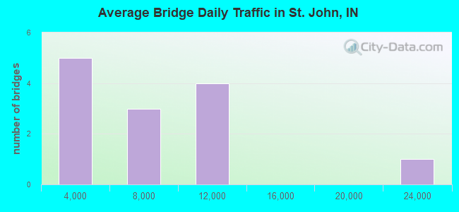
- 93,730Total average daily traffic
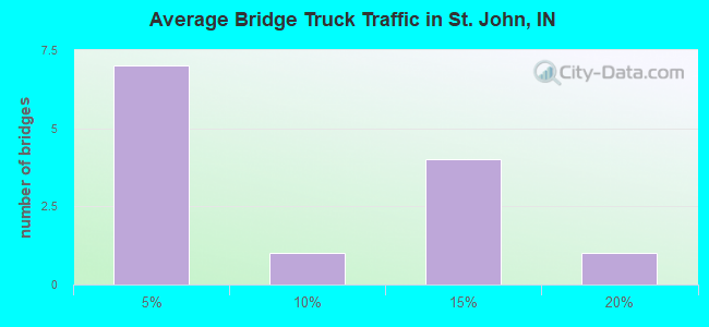
- 6,919Total average daily truck traffic
- National Bridge Inventory (NBI) Registered Bridges for St. John
- No street view available for this location
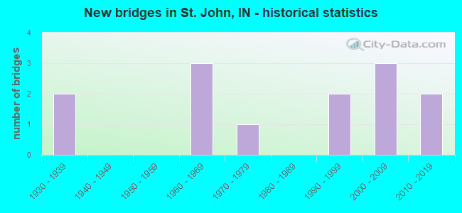
- New bridges - historical statistics
- 21930-1939
- 31960-1969
- 11970-1979
- 21990-1999
- 32000-2009
- 22010-2019
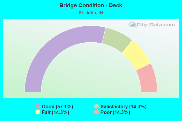
- Bridge Condition - Deck
- 57.1%Good
- 14.3%Satisfactory
- 14.3%Fair
- 14.3%Poor
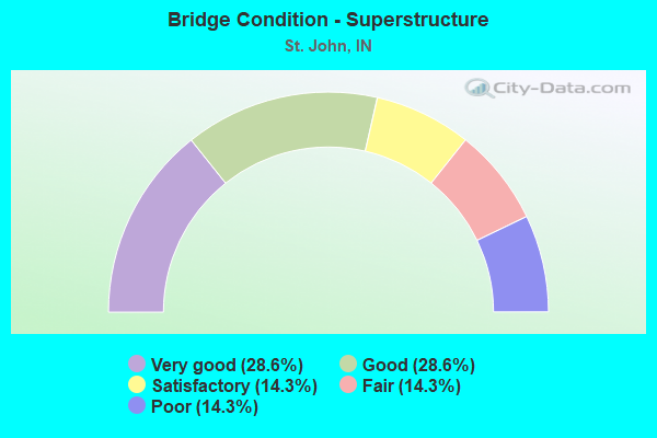
- Bridge Condition - Superstructure
- 28.6%Very good
- 28.6%Good
- 14.3%Satisfactory
- 14.3%Fair
- 14.3%Poor
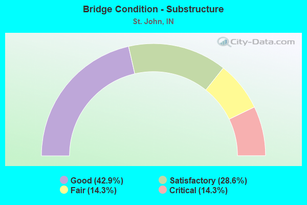
- Bridge Condition - Substructure
- 42.9%Good
- 28.6%Satisfactory
- 14.3%Fair
- 14.3%Critical
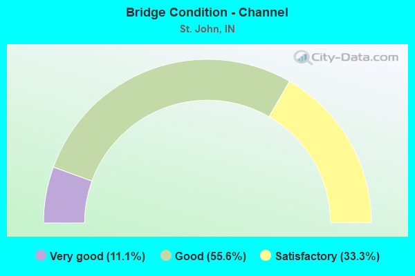
- Bridge Condition - Channel
- 11.1%Very good
- 55.6%Good
- 33.3%Satisfactory
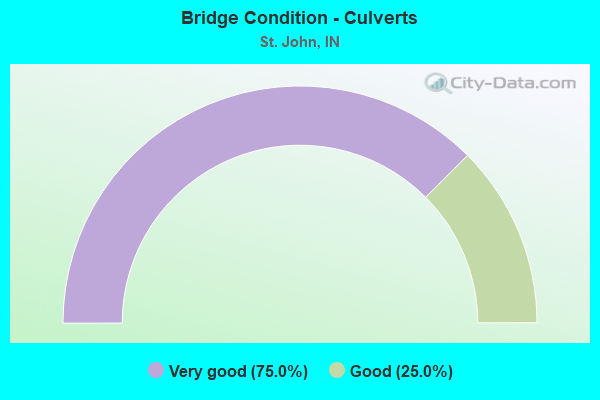
- Bridge Condition - Culverts
- 75.0%Very good
- 25.0%Good
Find on map >> Show street view
Structure Number: 1563, Location: 02.34 N US 231 (Lat: 41.455281, Lng: -87.470261), Route carried "on" structure: US 41, Year Built: 1962, Year Reconstructed: 2015, Status: Open, Structure Length: 1.98m (6.50ft), Average Daily Traffic: 23,923 (year 2004), Truck Traffic: 5%, Average Future Daily Traffic: 33,707 (year 2030), Design Load: HS 20+Mod, Features Intersected: CSX RR
Minimum Vertical Clearance: 30+ m (98+ ft), Kilometerpoint: 31.527, Lanes on structure: 4, Base Highway Network: Yes (, Subroute: 1), Owner: State Highway Agency, Approaching Roadway Width: 19.1m (62.7ft), Skew: 5 degrees, Material/Design: Steel, Design/Construction: Stringer/Multi-beam, Number Of Spans In Main Unit: 1, Length of Maximum Span: 18.8m (61.7ft), Curb or Sidewalk Widths: Left: 1.8m (5.9ft), Right: 0.0m, Curb-To-Curb Width: 19.4m (63.6ft), Out-to-Out Width: 22.1m (72.5ft)
Condition: Deck: Good, Superstructure: Good, Substructure: Satisfactory, Operating Rating: 64.5 metric tons, Method Used To Determine Operating Rating: Load and Resistance Factor Rating (LRFR) rating reported by rating factor(RF) method using HL-93 loadings, Inventory Rating: 49.9 metric tons, Method Used To Determine Inventory Rating: Load and Resistance Factor Rating (LRFR) rating reported by rating factor(RF) method using HL-93 loadings, Structural Evaluation: Equal to present minimum criteria, Deck Geometry: Somewhat better than minimum adequacy, Underclear: Meets minimum limits, Approach Roadway Alignment: Equal to present desirable criteria, Designated Inspection Frequency: Every 24 months, Inspection Date: January 2021, Deck Structure Type: Concrete Cast-file-Place, Wearing Surface/Protective System: Wearing Surface: Latex Concrete
Find on map >> Show street view
Structure Number: 4500044, Location: 00.30 E. of WHITE OAK Ave (Lat: 41.406619, Lng: -87.483331), Route carried "on" structure: County highway , Year Built: 1970, Status: Temporarily open, Structure Length: 1.23m (4.04ft), Average Daily Traffic: 642 (year 2021), Truck Traffic: 1%, Average Future Daily Traffic: 784 (year 2041), Features Intersected: WEST CREEK, Facility Carried by Structure: 117TH AVENUE
Minimum Vertical Clearance: 30+ m (98+ ft), Kilometerpoint: 0.000, Lanes on structure: 2, Owner: County Highway Agency, Approaching Roadway Width: 6.1m (20.0ft), Material/Design: Prestressed concrete, Design/Construction: Box Beam or Girders - Multiple, Number Of Spans In Main Unit: 1, Length of Maximum Span: 12.0m (39.4ft), Curb or Sidewalk Widths: Left: 0.3m (1.0ft), Right: 0.3m (1.0ft), Curb-To-Curb Width: 7.5m (24.6ft), Out-to-Out Width: 8.1m (26.6ft)
Condition: Deck: Fair, Superstructure: Fair, Substructure: Critical, Channel: Satisfactory, Structural Evaluation: High priority of replacement, Deck Geometry: Meets minimum limits, Waterway Adequacy: Superior to present desirable criteria, Approach Roadway Alignment: Equal to present desirable criteria, Bridge Posting: Required (Relationship of Operating Rating to Maximum Legal Load: > 39.9% below), Length Of Structure Improvement: 2.10m (6.89ft), Designated Inspection Frequency: Every 12 months, Inspection Date: August 2021, Bridge Improvement Cost: $888,000, Roadway Improvement Cost: $43,000, Total Project Cost: $931,000 ( Estimate for 2021), Deck Structure Type: Concrete Precast Panels, Wearing Surface/Protective System: Wearing Surface: Bituminous
Find on map >> Show street view
Structure Number: 450005, Location: 00.30 N of 61st Ave (Lat: 41.511911, Lng: -87.306939), Route carried "on" structure: City street , Year Built: 1998, Status: Open, Structure Length: 3.84m (12.60ft), Average Daily Traffic: 6,025 (year 2012), Truck Traffic: 3%, Average Future Daily Traffic: 7,804 (year 2038), Design Load: HS 20, Features Intersected: TURKEY CREEK, Facility Carried by Structure: LIVERPOOL ROAD
Minimum Vertical Clearance: 30+ m (98+ ft), Kilometerpoint: 0.000, Lanes on structure: 2, Owner: County Highway Agency, Approaching Roadway Width: 7.0m (23.0ft), Skew: 3 degrees, Material/Design: Prestressed concrete continuous, Design/Construction: Box Beam or Girders - Single/Spread, Number Of Spans In Main Unit: 3, Length of Maximum Span: 13.0m (42.7ft), Curb-To-Curb Width: 9.1m (29.9ft), Out-to-Out Width: 10.1m (33.1ft)
Condition: Deck: Good, Superstructure: Very good, Substructure: Satisfactory, Channel: Satisfactory, Operating Rating: 54.5 metric tons, Method Used To Determine Operating Rating: Field evaluation and documented engineering judgment, Inventory Rating: 32.7 metric tons, Method Used To Determine Inventory Rating: Field evaluation and documented engineering judgment, Structural Evaluation: Equal to present minimum criteria, Deck Geometry: High priority of corrective action, Waterway Adequacy: Superior to present desirable criteria, Approach Roadway Alignment: Equal to present desirable criteria, Designated Inspection Frequency: Every 24 months, Inspection Date: August 2020, Deck Structure Type: Concrete Cast-file-Place, Wearing Surface/Protective System: Wearing Surface: Monolithic Concrete, Deck Protection: Epoxy Coated Reinforcing
Find on map >> Show street view
Structure Number: 4500059, Location: 00.00 Int of WHITE OAK Av (Lat: 41.435581, Lng: -87.489331), Route carried "on" structure: City street , Year Built: 1993, Status: Open, Structure Length: 0.98m (3.22ft), Average Daily Traffic: 2,886 (year 2012), Truck Traffic: 1%, Average Future Daily Traffic: 3,814 (year 2040), Design Load: HS 20, Features Intersected: BULL RUN DITCH, Facility Carried by Structure: 101ST AVENUE
Minimum Vertical Clearance: 30+ m (98+ ft), Kilometerpoint: 0.000, Lanes on structure: 2, Owner: County Highway Agency, Approaching Roadway Width: 6.3m (20.7ft), Skew: 3 degrees, Material/Design: Concrete, Design/Construction: Culvert, Number Of Spans In Main Unit: 1, Length of Maximum Span: 9.1m (29.9ft)
Condition: Channel: Good, Culverts: Good, Operating Rating: 54.5 metric tons, Method Used To Determine Operating Rating: Field evaluation and documented engineering judgment, Inventory Rating: 32.7 metric tons, Method Used To Determine Inventory Rating: Field evaluation and documented engineering judgment, Structural Evaluation: Better than present minimum criteria, Waterway Adequacy: Superior to present desirable criteria, Approach Roadway Alignment: Equal to present desirable criteria, Designated Inspection Frequency: Every 24 months, Inspection Date: August 2020
Find on map >> Show street view
Structure Number: 4500115, Location: 00.30 W. of US 41 (Lat: 41.421200, Lng: -87.477331), Route carried "on" structure: City street , Year Built: 1966, Status: Open, Structure Length: 1.20m (3.94ft), Average Daily Traffic: 11,794 (year 2019), Truck Traffic: 16%, Average Future Daily Traffic: 14,391 (year 2040), Features Intersected: WEST CREEK, Facility Carried by Structure: 109TH AVENUE
Minimum Vertical Clearance: 30+ m (98+ ft), Kilometerpoint: 0.000, Lanes on structure: 2, Owner: County Highway Agency, Approaching Roadway Width: 7.0m (23.0ft), Material/Design: Prestressed concrete, Design/Construction: Box Beam or Girders - Multiple, Number Of Spans In Main Unit: 1, Length of Maximum Span: 11.4m (37.4ft), Curb or Sidewalk Widths: Left: 0.3m (1.0ft), Right: 0.3m (1.0ft), Curb-To-Curb Width: 7.6m (24.9ft), Out-to-Out Width: 8.1m (26.6ft)
Condition: Deck: Satisfactory, Superstructure: Satisfactory, Substructure: Good, Channel: Good, Operating Rating: 53.9 metric tons, Method Used To Determine Operating Rating: Load Factor (LF), Inventory Rating: 32.3 metric tons, Method Used To Determine Inventory Rating: Load Factor (LF), Structural Evaluation: Equal to present minimum criteria, Deck Geometry: High priority of replacement, Waterway Adequacy: Superior to present desirable criteria, Approach Roadway Alignment: Equal to present desirable criteria, Length Of Structure Improvement: 1.22m (4.00ft), Designated Inspection Frequency: Every 24 months, Inspection Date: August 2020, Bridge Improvement Cost: $80,000, Roadway Improvement Cost: $30,000, Total Project Cost: $110,000 ( Estimate for 2020), Deck Structure Type: Concrete Precast Panels, Wearing Surface/Protective System: Wearing Surface: Bituminous
Find on map >> Show street view
Structure Number: 4500159, Location: 00.40 E. of US 41 (Lat: 41.443689, Lng: -87.464000), Route carried "on" structure: City street , Year Built: 1969, Status: Posted for load, Structure Length: 0.91m (2.99ft), Average Daily Traffic: 5,542 (year 2019), Truck Traffic: 11%, Average Future Daily Traffic: 6,899 (year 2041), Features Intersected: ST JOHN DITCH, Facility Carried by Structure: JOLIET STREET
Minimum Vertical Clearance: 30+ m (98+ ft), Kilometerpoint: 0.000, Lanes on structure: 2, Owner: County Highway Agency, Approaching Roadway Width: 6.5m (21.3ft), Material/Design: Concrete, Design/Construction: Channel Beam, Number Of Spans In Main Unit: 1, Length of Maximum Span: 8.8m (28.9ft), Curb or Sidewalk Widths: Left: 0.3m (1.0ft), Right: 0.8m (2.6ft), Curb-To-Curb Width: 7.5m (24.6ft), Out-to-Out Width: 9.1m (29.9ft)
Condition: Deck: Poor, Superstructure: Poor, Substructure: Fair, Channel: Satisfactory, Operating Rating: 44.3 metric tons, Method Used To Determine Operating Rating: Load Factor (LF), Inventory Rating: 26.5 metric tons, Method Used To Determine Inventory Rating: Load Factor (LF), Structural Evaluation: Meets minimum limits, Deck Geometry: High priority of replacement, Waterway Adequacy: Superior to present desirable criteria, Approach Roadway Alignment: Equal to present minimum criteria, Length Of Structure Improvement: 1.68m (5.51ft), Designated Inspection Frequency: Every 12 months, Inspection Date: August 2021, Bridge Improvement Cost: $594,000, Roadway Improvement Cost: $107,000, Total Project Cost: $701,000 ( Estimate for 2021), Deck Structure Type: Concrete Precast Panels, Wearing Surface/Protective System: Wearing Surface: Bituminous
Find on map >> Show street view
Structure Number: 4500208, Location: 00.10 E. of ROSEWOOD DR. (Lat: 41.442650, Lng: -87.486081), Route carried "on" structure: City street , Year Built: 2000, Status: Open, Structure Length: 1.04m (3.41ft), Average Daily Traffic: 65 (year 2016), Truck Traffic: 2%, Average Future Daily Traffic: 83 (year 2040), Design Load: HS 20, Features Intersected: BULL RUN DITCH, Facility Carried by Structure: ALVINA ROSE COURT
Minimum Vertical Clearance: 30+ m (98+ ft), Kilometerpoint: 0.000, Lanes on structure: 2, Owner: County Highway Agency, Approaching Roadway Width: 8.2m (26.9ft), Material/Design: Concrete, Design/Construction: Culvert, Number Of Spans In Main Unit: 1, Length of Maximum Span: 9.8m (32.2ft), Curb or Sidewalk Widths: Left: 1.5m (4.9ft), Right: 0.5m (1.6ft)
Condition: Channel: Good, Culverts: Very good, Operating Rating: 54.5 metric tons, Method Used To Determine Operating Rating: Field evaluation and documented engineering judgment, Inventory Rating: 32.7 metric tons, Method Used To Determine Inventory Rating: Field evaluation and documented engineering judgment, Structural Evaluation: Equal to present desirable criteria, Waterway Adequacy: Superior to present desirable criteria, Approach Roadway Alignment: Equal to present desirable criteria, Designated Inspection Frequency: Every 24 months, Inspection Date: August 2020
Find on map >> Show street view
Structure Number: 4500215, Location: 00.20 W. of WHITE OAK Ave (Lat: 41.435569, Lng: -87.492250), Route carried "on" structure: City street , Year Built: 2010, Status: Posted for load, Structure Length: 1.28m (4.20ft), Average Daily Traffic: 3,569 (year 2012), Truck Traffic: 1%, Average Future Daily Traffic: 4,716 (year 2040), Design Load: HS 20, Features Intersected: BULL RUN DITCH, Facility Carried by Structure: 101ST AVENUE
Minimum Vertical Clearance: 30+ m (98+ ft), Kilometerpoint: 0.000, Lanes on structure: 2, Owner: County Highway Agency, Approaching Roadway Width: 9.1m (29.9ft), Skew: 4 degrees, Material/Design: Aluminum, Iron, Design/Construction: Culvert, Number Of Spans In Main Unit: 1, Length of Maximum Span: 10.3m (33.8ft), Curb-To-Curb Width: 9.3m (30.5ft), Out-to-Out Width: 9.3m (30.5ft)
Condition: Channel: Good, Culverts: Very good, Operating Rating: 45.8 metric tons, Method Used To Determine Operating Rating: Load and Resistance Factor (LRFR), Inventory Rating: 35.3 metric tons, Method Used To Determine Inventory Rating: Load and Resistance Factor (LRFR), Structural Evaluation: Equal to present desirable criteria, Deck Geometry: Meets minimum limits, Waterway Adequacy: Better than present minimum criteria, Approach Roadway Alignment: Equal to present desirable criteria, Designated Inspection Frequency: Every 24 months, Inspection Date: August 2020
Find on map >> Show street view
Structure Number: 4500388, Location: 00.30 N. OF 69TH AVENUE (Lat: 41.497281, Lng: -87.318114), Route carried "on" structure: County highway , Year Built: 2004, Status: Open, Structure Length: 6.05m (19.85ft), Average Daily Traffic: 10,846 (year 2012), Truck Traffic: 1%, Average Future Daily Traffic: 14,049 (year 2038), Design Load: HS 20, Features Intersected: GRAND TRUNK RAILROAD, Facility Carried by Structure: MISSISSIPPI STREET
Minimum Vertical Clearance: 30+ m (98+ ft), Kilometerpoint: 0.000, Lanes on structure: 4, Owner: County Highway Agency, Approaching Roadway Width: 15.5m (50.9ft), Skew: 1 degrees, Material/Design: Prestressed concrete continuous, Design/Construction: Stringer/Multi-beam, Number Of Spans In Main Unit: 3, Length of Maximum Span: 20.7m (67.9ft), Curb or Sidewalk Widths: Left: 1.8m (5.9ft), Right: 1.8m (5.9ft), Curb-To-Curb Width: 15.5m (50.9ft), Out-to-Out Width: 20.1m (65.9ft)
Condition: Deck: Good, Superstructure: Very good, Substructure: Good, Operating Rating: 58.6 metric tons, Method Used To Determine Operating Rating: Load Factor (LF), Inventory Rating: 31.2 metric tons, Method Used To Determine Inventory Rating: Load Factor (LF), Structural Evaluation: Better than present minimum criteria, Deck Geometry: Meets minimum limits, Underclear: Superior to present desirable criteria, Approach Roadway Alignment: Equal to present desirable criteria, Designated Inspection Frequency: Every 24 months, Inspection Date: August 2020, Deck Structure Type: Concrete Cast-file-Place, Wearing Surface/Protective System: Wearing Surface: Monolithic Concrete, Deck Protection: Epoxy Coated Reinforcing
Find on map >> Show street view
Structure Number: 4500389, Location: 00.40 S. OF W. 97TH LANE (Lat: 41.435989, Lng: -87.475119), Route carried "on" structure: City street , Year Built: 2009, Status: Posted for load, Structure Length: 1.58m (5.18ft), Average Daily Traffic: 800 (year 2011), Truck Traffic: 2%, Average Future Daily Traffic: 1,068 (year 2040), Design Load: HS 20, Features Intersected: WEST CREEK, Facility Carried by Structure: HEDWIG DRIVE
Minimum Vertical Clearance: 30+ m (98+ ft), Kilometerpoint: 0.000, Lanes on structure: 2, Owner: County Highway Agency, Approaching Roadway Width: 11.7m (38.4ft), Material/Design: Steel, Design/Construction: Stringer/Multi-beam, Number Of Spans In Main Unit: 1, Length of Maximum Span: 14.9m (48.9ft), Curb or Sidewalk Widths: Left: 0.0m, Right: 1.4m (4.6ft), Curb-To-Curb Width: 12.2m (40.0ft), Out-to-Out Width: 14.7m (48.2ft)
Condition: Deck: Good, Superstructure: Good, Substructure: Good, Channel: Good, Operating Rating: 42.9 metric tons, Method Used To Determine Operating Rating: Load Factor (LF), Inventory Rating: 25.7 metric tons, Method Used To Determine Inventory Rating: Load Factor (LF), Structural Evaluation: Equal to present minimum criteria, Deck Geometry: Equal to present desirable criteria, Waterway Adequacy: Equal to present desirable criteria, Approach Roadway Alignment: Equal to present desirable criteria, Length Of Structure Improvement: 1.52m (4.99ft), Designated Inspection Frequency: Every 24 months, Inspection Date: August 2020, Bridge Improvement Cost: $50,000, Total Project Cost: $50,000 ( Estimate for 2020), Deck Structure Type: Concrete Cast-file-Place, Wearing Surface/Protective System: Wearing Surface: Monolithic Concrete
Find on map >> Show street view
Structure Number: 45004, Location: 00.11 S of 93rd AVE (Lat: 41.448189, Lng: -87.426519), Route carried "on" structure: County highway , Year Built: 2018, Status: Open, Structure Length: 0.77m (2.53ft), Average Daily Traffic: 4,516 (year 2019), Truck Traffic: 12%, Average Future Daily Traffic: 5,566 (year 2040), Features Intersected: MAIN BEAVER DAM DITCH, Facility Carried by Structure: BLAINE ST.
Minimum Vertical Clearance: 30+ m (98+ ft), Kilometerpoint: 0.000, Lanes on structure: 2, Owner: County Highway Agency, Approaching Roadway Width: 7.3m (24.0ft), Material/Design: Concrete, Design/Construction: Culvert, Number Of Spans In Main Unit: 1, Length of Maximum Span: 7.3m (24.0ft)
Condition: Channel: Very good, Culverts: Very good, Operating Rating: 64.4 metric tons, Method Used To Determine Operating Rating: Field evaluation and documented engineering judgment, Inventory Rating: 38.5 metric tons, Method Used To Determine Inventory Rating: Field evaluation and documented engineering judgment, Structural Evaluation: Equal to present desirable criteria, Waterway Adequacy: Superior to present desirable criteria, Approach Roadway Alignment: Equal to present desirable criteria, Designated Inspection Frequency: Every 24 months, Inspection Date: August 2020
Find on map >> Show street view
Structure Number: 209, Location: 00.23 S US 41 (Lat: 41.421131, Lng: -87.465600), Route carried "under" structure: US 231, Year Built: 1934, Structure Length: 0. m, Average Daily Traffic: 11,561 (year 2004), Truck Traffic: 10%, Features Intersected: US 231, Facility Carried by Structure: N&S RR
Minimum Vertical Clearance: 4.14m (13.58ft), Kilometerpoint: 24.092, Lanes under structure: 2, Material/Design: Steel, Design/Construction: Stringer/Multi-beam, Length of Maximum Span: 9.2m (30.2ft)
Find on map >> Show street view
Structure Number: 21, Location: 00.82 S US 41 (Lat: 41.421069, Lng: -87.454553), Route carried "under" structure: US 231, Year Built: 1934, Structure Length: 0. m, Average Daily Traffic: 11,561 (year 2004), Truck Traffic: 10%, Features Intersected: US 231, Facility Carried by Structure: CSX RR
Minimum Vertical Clearance: 4.14m (13.58ft), Kilometerpoint: 23.142, Lanes under structure: 2, Material/Design: Steel, Design/Construction: Stringer/Multi-beam, Length of Maximum Span: 10.1m (33.1ft)