Bridge Statistics for St. Ignace, Michigan (MI)
Condition, Traffic, Stress, Structural Evaluation, Project Costs
- National Bridge Inventory (NBI) Statistics
- 12Number of bridges
- 102ft / 30.9mTotal length
- 39,259Total average daily traffic
- 3,024Total average daily truck traffic
- National Bridge Inventory (NBI) Registered Bridges for St. Ignace
- No street view available for this location
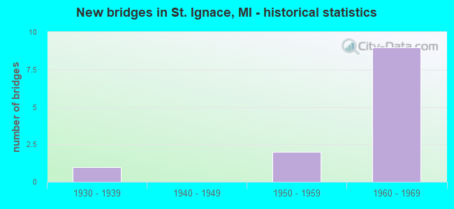
- New bridges - historical statistics
- 11930-1939
- 21950-1959
- 91960-1969

- Reconstructed bridges - Historical Statistics
- 11990-1999
- 02000-2009
- 12010-2019


- Bridge Condition - Deck
- 33.3%Good
- 50.0%Satisfactory
- 16.7%Fair

- Bridge Condition - Superstructure
- 50.0%Good
- 16.7%Satisfactory
- 33.3%Fair

- Bridge Condition - Substructure
- 16.7%Good
- 50.0%Satisfactory
- 16.7%Fair
- 16.7%Poor
Find on map >> Show street view
Structure Number: 5948, Location: IN ST IGNACE (CO RD 4914) (Lat: 45.877283, Lng: -84.739311), Route carried "on" structure: Interstate 75, Year Built: 1960, Status: Open, Structure Length: 8.47m (27.79ft), Average Daily Traffic: 2,555 (year 2007), Truck Traffic: 8%, Average Future Daily Traffic: 6,165 (year 2018), Design Load: HS 20+Mod, Features Intersected: CHEESEMAN RD & RR (ABN)
Minimum Vertical Clearance: 30+ m (98+ ft), Kilometerpoint: 10.408, Lanes on structure: 2, Lanes under structure: 2, Base Highway Network: Yes (Inventory Route: 114, Subroute: 5), Owner: State Highway Agency, Approaching Roadway Width: 10.9m (35.8ft), Skew: 13 degrees, Material/Design: Steel, Design/Construction: Stringer/Multi-beam, Number Of Spans In Main Unit: 4, Length of Maximum Span: 21.9m (71.9ft), Curb-To-Curb Width: 10.3m (33.8ft), Out-to-Out Width: 10.6m (34.8ft)
Condition: Deck: Fair, Superstructure: Fair, Substructure: Poor, Operating Rating: 80.7 metric tons, Method Used To Determine Operating Rating: Load Factor (LF) rating reported by rating factor (RF) method using MS18 loading, Inventory Rating: 48.3 metric tons, Method Used To Determine Inventory Rating: Load Factor (LF) rating reported by rating factor (RF) method using MS18 loading, Structural Evaluation: Meets minimum limits, Deck Geometry: Meets minimum limits, Underclear: Somewhat better than minimum adequacy, Approach Roadway Alignment: Equal to present minimum criteria, Designated Inspection Frequency: Every 12 months, Inspection Date: May 2021, Bridge Improvement Cost: $171,000, Deck Structure Type: Concrete Cast-file-Place, Wearing Surface/Protective System: Wearing Surface: Latex Concrete
Find on map >> Show street view
Structure Number: 5949, Location: IN ST IGNACE I-75 (Lat: 45.857628, Lng: -84.727950), Route carried "on" structure: US 2, Year Built: 1957, Year Reconstructed: 1997, Status: Open, Structure Length: 5.88m (19.29ft), Average Daily Traffic: 7,950 (year 2007), Truck Traffic: 8%, Average Future Daily Traffic: 11,023 (year 2018), Design Load: HS 20, Features Intersected: I-75
Minimum Vertical Clearance: 30.48m (100.00ft), Kilometerpoint: 100.192, Lanes on structure: 5, Lanes under structure: 5, Base Highway Network: Yes (Inventory Route: 114, Subroute: 8), Owner: State Highway Agency, Approaching Roadway Width: 21.3m (69.9ft), Skew: 22 degrees, Material/Design: Steel, Design/Construction: Stringer/Multi-beam, Number Of Spans In Main Unit: 4, Length of Maximum Span: 19.9m (65.3ft), Curb-To-Curb Width: 23.5m (77.1ft), Out-to-Out Width: 24.5m (80.4ft)
Condition: Deck: Good, Superstructure: Fair, Substructure: Fair, Operating Rating: 74.2 metric tons, Method Used To Determine Operating Rating: Load Factor (LF) rating reported by rating factor (RF) method using MS18 loading, Inventory Rating: 44.4 metric tons, Method Used To Determine Inventory Rating: Load Factor (LF) rating reported by rating factor (RF) method using MS18 loading, Structural Evaluation: Somewhat better than minimum adequacy, Deck Geometry: Better than present minimum criteria, Underclear: Meets minimum limits, Approach Roadway Alignment: Better than present minimum criteria, Designated Inspection Frequency: Every 12 months, Inspection Date: August 2021, Deck Structure Type: Concrete Cast-file-Place, Wearing Surface/Protective System: Wearing Surface: Monolithic Concrete
Find on map >> Show street view
Structure Number: 595, Location: IN ST IGNACE, PORTAGE ST (Lat: 45.866681, Lng: -84.734539), Route carried "on" structure: Interstate 75, Year Built: 1960, Status: Open, Structure Length: 4.20m (13.78ft), Average Daily Traffic: 2,555 (year 2007), Truck Traffic: 8%, Average Future Daily Traffic: 5,997 (year 2018), Design Load: HS 20+Mod, Features Intersected: PORTAGE ST
Minimum Vertical Clearance: 30.48m (100.00ft), Kilometerpoint: 9.148, Lanes on structure: 2, Lanes under structure: 2, Base Highway Network: Yes (Inventory Route: 114, Subroute: 7), Owner: State Highway Agency, Approaching Roadway Width: 12.8m (42.0ft), Skew: 10 degrees, Material/Design: Steel, Design/Construction: Stringer/Multi-beam, Number Of Spans In Main Unit: 3, Length of Maximum Span: 17.3m (56.8ft), Curb-To-Curb Width: 12.8m (42.0ft), Out-to-Out Width: 14.3m (46.9ft)
Condition: Deck: Satisfactory, Superstructure: Good, Substructure: Satisfactory, Operating Rating: 61.6 metric tons, Method Used To Determine Operating Rating: Load Factor (LF) rating reported by rating factor (RF) method using MS18 loading, Inventory Rating: 36.9 metric tons, Method Used To Determine Inventory Rating: Load Factor (LF) rating reported by rating factor (RF) method using MS18 loading, Structural Evaluation: Equal to present minimum criteria, Deck Geometry: Equal to present desirable criteria, Underclear: Better than present minimum criteria, Approach Roadway Alignment: Better than present minimum criteria, Designated Inspection Frequency: Every 24 months, Inspection Date: October 2020, Deck Structure Type: Concrete Cast-file-Place, Wearing Surface/Protective System: Wearing Surface: Latex Concrete
Find on map >> Show street view
Structure Number: 5951, Location: IN ST IGNACE, PORTAGE ST (Lat: 45.866644, Lng: -84.734864), Route carried "on" structure: Interstate 75, Year Built: 1960, Status: Open, Structure Length: 4.20m (13.78ft), Average Daily Traffic: 2,555 (year 2007), Truck Traffic: 8%, Average Future Daily Traffic: 5,997 (year 2018), Design Load: HS 20+Mod, Features Intersected: PORTAGE ST
Minimum Vertical Clearance: 30.48m (100.00ft), Kilometerpoint: 9.148, Lanes on structure: 2, Lanes under structure: 2, Base Highway Network: Yes (Inventory Route: 114, Subroute: 5), Owner: State Highway Agency, Approaching Roadway Width: 12.8m (42.0ft), Skew: 10 degrees, Material/Design: Steel, Design/Construction: Stringer/Multi-beam, Number Of Spans In Main Unit: 3, Length of Maximum Span: 17.3m (56.8ft), Curb-To-Curb Width: 12.8m (42.0ft), Out-to-Out Width: 14.3m (46.9ft)
Condition: Deck: Satisfactory, Superstructure: Good, Substructure: Satisfactory, Operating Rating: 61.6 metric tons, Method Used To Determine Operating Rating: Load Factor (LF) rating reported by rating factor (RF) method using MS18 loading, Inventory Rating: 36.9 metric tons, Method Used To Determine Inventory Rating: Load Factor (LF) rating reported by rating factor (RF) method using MS18 loading, Structural Evaluation: Equal to present minimum criteria, Deck Geometry: Equal to present desirable criteria, Underclear: Better than present minimum criteria, Approach Roadway Alignment: Better than present minimum criteria, Designated Inspection Frequency: Every 24 months, Inspection Date: October 2020, Deck Structure Type: Concrete Cast-file-Place, Wearing Surface/Protective System: Wearing Surface: Latex Concrete
Find on map >> Show street view
Structure Number: 5952, Location: @ N JCT I-75 BL (Lat: 45.907525, Lng: -84.740025), Route carried "on" structure: Business Interstate 75, Year Built: 1960, Year Reconstructed: 2015, Status: Open, Structure Length: 7.51m (24.64ft), Average Daily Traffic: 4,350 (year 2015), Truck Traffic: 3%, Average Future Daily Traffic: 5,050 (year 2035), Design Load: HS 20, Features Intersected: I-75
Minimum Vertical Clearance: 30.48m (100.00ft), Kilometerpoint: 107.595, Lanes on structure: 2, Lanes under structure: 4, Base Highway Network: Yes (Inventory Route: 114, Subroute: 8), Owner: State Highway Agency, Approaching Roadway Width: 11.0m (36.1ft), Skew: 4 degrees, Material/Design: Steel, Design/Construction: Stringer/Multi-beam, Number Of Spans In Main Unit: 4, Length of Maximum Span: 23.7m (77.8ft), Curb-To-Curb Width: 10.0m (32.8ft), Out-to-Out Width: 11.2m (36.7ft)
Condition: Deck: Good, Superstructure: Good, Substructure: Good, Operating Rating: 82.9 metric tons, Method Used To Determine Operating Rating: Load Factor (LF) rating reported by rating factor (RF) method using MS18 loading, Inventory Rating: 49.9 metric tons, Method Used To Determine Inventory Rating: Load Factor (LF) rating reported by rating factor (RF) method using MS18 loading, Structural Evaluation: Better than present minimum criteria, Deck Geometry: Meets minimum limits, Underclear: Somewhat better than minimum adequacy, Approach Roadway Alignment: Equal to present desirable criteria, Designated Inspection Frequency: Every 24 months, Inspection Date: October 2020, Deck Structure Type: Concrete Cast-file-Place, Wearing Surface/Protective System: Wearing Surface: Latex Concrete
Find on map >> Show street view
Structure Number: 5984, Location: 1 MI N B L 75 ON CTY RD 4 (Lat: 45.919853, Lng: -84.734500), Route carried "on" structure: County highway 4963, Year Built: 1930, Status: Open, Structure Length: 0.64m (2.10ft), Average Daily Traffic: 2,020 (year 2015), Truck Traffic: 7%, Average Future Daily Traffic: 2,300 (year 2035), Features Intersected: RABBITS BACK CREEK, Facility Carried by Structure: MACKINAC TRL. FH41
Minimum Vertical Clearance: 30.48m (100.00ft), Kilometerpoint: 1.827, Lanes on structure: 2, Owner: County Highway Agency, Approaching Roadway Width: 9.1m (29.9ft), Skew: 4 degrees, Material/Design: Concrete, Design/Construction: Slab, Number Of Spans In Main Unit: 1, Length of Maximum Span: 6.4m (21.0ft), Curb-To-Curb Width: 12.2m (40.0ft), Out-to-Out Width: 12.6m (41.3ft)
Condition: Deck: Satisfactory, Superstructure: Satisfactory, Substructure: Satisfactory, Channel: Good, Operating Rating: 32.7 metric tons, Method Used To Determine Operating Rating: Field evaluation and documented engineering judgment, Inventory Rating: 32.7 metric tons, Method Used To Determine Inventory Rating: Field evaluation and documented engineering judgment, Structural Evaluation: Equal to present minimum criteria, Deck Geometry: Equal to present minimum criteria, Waterway Adequacy: Equal to present minimum criteria, Approach Roadway Alignment: Better than present minimum criteria, Designated Inspection Frequency: Every 24 months, Inspection Date: October 2021, Deck Structure Type: Concrete Cast-file-Place, Wearing Surface/Protective System: Wearing Surface: Bituminous
Find on map >> Show street view
Structure Number: 5947, Location: IN ST IGNACE (Lat: 45.877156, Lng: -84.738889), Route carried "under" structure: County highway 4914, Year Built: 1960, Structure Length: 0. m, Average Daily Traffic: 149 (year 1992), Truck Traffic: 10%, Features Intersected: CHEESEMAN RD & RR (ABN), Facility Carried by Structure: I-75 NB
Minimum Vertical Clearance: 30+ m (98+ ft), Kilometerpoint: 8.271, Lanes on structure: 2, Lanes under structure: 2, Material/Design: Steel, Design/Construction: Stringer/Multi-beam, Length of Maximum Span: 21.9m (71.9ft)
Find on map >> Show street view
Structure Number: 5948, Location: IN ST IGNACE (CO RD 4914) (Lat: 45.877283, Lng: -84.739311), Route carried "under" structure: County highway 4914, Year Built: 1960, Structure Length: 0. m, Average Daily Traffic: 149 (year 1992), Truck Traffic: 10%, Features Intersected: CHEESEMAN RD & RR (ABN), Facility Carried by Structure: I-75 SB
Minimum Vertical Clearance: 30+ m (98+ ft), Kilometerpoint: 8.243, Lanes on structure: 2, Lanes under structure: 2, Material/Design: Steel, Design/Construction: Stringer/Multi-beam, Length of Maximum Span: 21.9m (71.9ft)
Find on map >> Show street view
Structure Number: 5949, Location: IN ST IGNACE I-75 (Lat: 45.857628, Lng: -84.727950), Route carried "under" structure: Interstate 75, Year Built: 1957, Structure Length: 0. m, Average Daily Traffic: 11,076 (year 2007), Truck Traffic: 9%, Features Intersected: I-75
Minimum Vertical Clearance: 4.88m (16.01ft), Kilometerpoint: 8.008, Lanes on structure: 5, Lanes under structure: 5, Material/Design: Steel, Design/Construction: Stringer/Multi-beam, Length of Maximum Span: 19.9m (65.3ft)
Find on map >> Show street view
Structure Number: 595, Location: IN ST IGNACE, PORTAGE ST (Lat: 45.866681, Lng: -84.734539), Route carried "under" structure: City street , Year Built: 1960, Structure Length: 0. m, Average Daily Traffic: 289 (year 1986), Truck Traffic: 10%, Features Intersected: PORTAGE ST, Facility Carried by Structure: I-75 NB
Minimum Vertical Clearance: 4.88m (16.01ft), Kilometerpoint: 2.625, Lanes on structure: 2, Lanes under structure: 2, Material/Design: Steel, Design/Construction: Stringer/Multi-beam, Length of Maximum Span: 17.3m (56.8ft)
Find on map >> Show street view
Structure Number: 5951, Location: IN ST IGNACE, PORTAGE ST (Lat: 45.866644, Lng: -84.734864), Route carried "under" structure: City street , Year Built: 1960, Structure Length: 0. m, Average Daily Traffic: 289 (year 1986), Truck Traffic: 10%, Features Intersected: PORTAGE ST, Facility Carried by Structure: I-75 SB
Minimum Vertical Clearance: 4.88m (16.01ft), Kilometerpoint: 2.599, Lanes on structure: 2, Lanes under structure: 2, Material/Design: Steel, Design/Construction: Stringer/Multi-beam, Length of Maximum Span: 17.3m (56.8ft)
Find on map >> Show street view
Structure Number: 5952, Location: @ N JCT I-75 BL (Lat: 45.907525, Lng: -84.740025), Route carried "under" structure: Interstate 75, Year Built: 1960, Structure Length: 0. m, Average Daily Traffic: 5,322 (year 2007), Truck Traffic: 8%, Features Intersected: I-75
Minimum Vertical Clearance: 5.26m (17.26ft), Kilometerpoint: 13.979, Lanes on structure: 2, Lanes under structure: 4, Material/Design: Steel, Design/Construction: Stringer/Multi-beam, Length of Maximum Span: 23.7m (77.8ft)