Bridge Statistics for St. Croix Falls, Wisconsin (WI)
Condition, Traffic, Stress, Structural Evaluation, Project Costs
- National Bridge Inventory (NBI) Statistics
- 10Number of bridges
- 108ft / 32.9mTotal length
- $2,378,000Total costs
- 78,515Total average daily traffic
- 5,613Total average daily truck traffic
- National Bridge Inventory (NBI) Registered Bridges for St. Croix Falls
- No street view available for this location
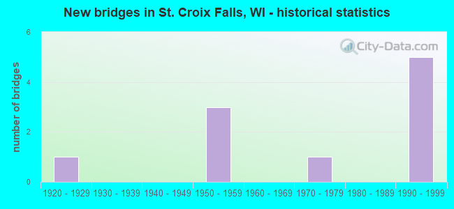
- New bridges - historical statistics
- 11920-1929
- 31950-1959
- 11970-1979
- 51990-1999


- Bridge Condition - Deck
- 16.7%Good
- 50.0%Satisfactory
- 33.3%Fair

- Bridge Condition - Superstructure
- 33.3%Good
- 50.0%Satisfactory
- 16.7%Fair

- Bridge Condition - Substructure
- 66.7%Good
- 33.3%Fair

- Bridge Condition - Channel
- 66.7%Very good
- 33.3%Satisfactory
Find on map >> Show street view
Structure Number: B480003, Location: MINNESOTA STATE LINE (Lat: 45.401756, Lng: -92.651167), Route carried "on" structure: US 8, Year Built: 1955, Year Reconstructed: 1986, Status: Open, Structure Length: 12.33m (40.45ft), Average Daily Traffic: 18,500 (year 2019), Truck Traffic: 9%, Average Future Daily Traffic: 13,500 (year 2039), Design Load: H 20, Features Intersected: ST CROIX RIVER 07
Minimum Vertical Clearance: 30+ m (98+ ft), Kilometerpoint: 0.000, Lanes on structure: 4, Base Highway Network: Yes, Owner: State Highway Agency, Approaching Roadway Width: 14.6m (47.9ft), Material/Design: Steel continuous, Design/Construction: Stringer/Multi-beam, Number Of Spans In Main Unit: 3, Length of Maximum Span: 48.8m (160.1ft), Curb or Sidewalk Widths: Left: 2.0m (6.6ft), Right: 2.0m (6.6ft), Curb-To-Curb Width: 14.6m (47.9ft), Out-to-Out Width: 19.1m (62.7ft)
Condition: Deck: Satisfactory, Superstructure: Satisfactory, Substructure: Good, Channel: Very good, Operating Rating: 29.4 metric tons, Method Used To Determine Operating Rating: Load Factor (LF), Inventory Rating: 17.8 metric tons, Method Used To Determine Inventory Rating: Load Factor (LF), Structural Evaluation: Meets minimum limits, Deck Geometry: High priority of replacement, Waterway Adequacy: Equal to present desirable criteria, Approach Roadway Alignment: Equal to present minimum criteria, Length Of Structure Improvement: 12.77m (41.90ft), Designated Inspection Frequency: Every 24 months, Underwater Inspection Frequency: Every 60 months, Other Special Inspection Frequency: Every 72 months, Inspection Date: September 2020, Underwater Inspection Date: July 2020, Other Special Inspection Date: April 2016, Bridge Improvement Cost: $1,585,000, Roadway Improvement Cost: $158,000, Total Project Cost: $2,378,000 ( Estimate for 2021), Deck Structure Type: Concrete Cast-file-Place, Wearing Surface/Protective System: Wearing Surface: Low Slump Concrete, Deck Protection: Epoxy Coated Reinforcing
Find on map >> Show street view
Structure Number: B480004, Location: 0.1M E MINN STATE LINE (Lat: 45.402014, Lng: -92.648786), Route carried "on" structure: US 8, Year Built: 1956, Year Reconstructed: 1994, Status: Open, Structure Length: 2.82m (9.25ft), Average Daily Traffic: 16,420 (year 2019), Truck Traffic: 10%, Average Future Daily Traffic: 21,220 (year 2036), Design Load: HS 20, Features Intersected: LRD INTERSTATE PARK RD
Minimum Vertical Clearance: 30+ m (98+ ft), Kilometerpoint: 0.000, Lanes on structure: 4, Lanes under structure: 2, Base Highway Network: Yes, Owner: State Highway Agency, Approaching Roadway Width: 16.5m (54.1ft), Material/Design: Steel continuous, Design/Construction: Stringer/Multi-beam, Number Of Spans In Main Unit: 3, Length of Maximum Span: 10.7m (35.1ft), Curb or Sidewalk Widths: Left: 2.0m (6.6ft), Right: 0.0m, Curb-To-Curb Width: 16.5m (54.1ft), Out-to-Out Width: 19.2m (63.0ft)
Condition: Deck: Fair, Superstructure: Satisfactory, Substructure: Fair, Operating Rating: 58.8 metric tons, Method Used To Determine Operating Rating: Load Factor (LF), Inventory Rating: 34.0 metric tons, Method Used To Determine Inventory Rating: Load Factor (LF), Structural Evaluation: Somewhat better than minimum adequacy, Deck Geometry: Meets minimum limits, Underclear: Meets minimum limits, Approach Roadway Alignment: Equal to present desirable criteria, Designated Inspection Frequency: Every 24 months, Inspection Date: September 2020, Deck Structure Type: Concrete Cast-file-Place, Wearing Surface/Protective System: Wearing Surface: Epoxy Overlay, Deck Protection: Epoxy Coated Reinforcing
Find on map >> Show street view
Structure Number: B48003, Location: 1.5M E JCT STH 65 (Lat: 45.395792, Lng: -92.459686), Route carried "on" structure: US 8, Year Built: 1990, Status: Open, Structure Length: 1.12m (3.67ft), Average Daily Traffic: 8,300 (year 2019), Truck Traffic: 8%, Average Future Daily Traffic: 11,120 (year 2039), Design Load: HS 20, Features Intersected: BALSAM BRANCH CREEK
Minimum Vertical Clearance: 30+ m (98+ ft), Kilometerpoint: 0.000, Lanes on structure: 2, Base Highway Network: Yes, Owner: State Highway Agency, Approaching Roadway Width: 13.4m (44.0ft), Material/Design: Concrete, Design/Construction: Slab, Number Of Spans In Main Unit: 1, Length of Maximum Span: 10.7m (35.1ft), Curb-To-Curb Width: 13.4m (44.0ft), Out-to-Out Width: 14.0m (45.9ft)
Condition: Deck: Satisfactory, Superstructure: Satisfactory, Substructure: Good, Channel: Very good, Operating Rating: 60.4 metric tons, Method Used To Determine Operating Rating: Load Factor (LF), Inventory Rating: 35.6 metric tons, Method Used To Determine Inventory Rating: Load Factor (LF), Structural Evaluation: Equal to present minimum criteria, Deck Geometry: Equal to present minimum criteria, Waterway Adequacy: Equal to present desirable criteria, Approach Roadway Alignment: Equal to present desirable criteria, Designated Inspection Frequency: Every 24 months, Inspection Date: September 2020, Deck Structure Type: Concrete Cast-file-Place, Wearing Surface/Protective System: Wearing Surface: Monolithic Concrete, Deck Protection: Epoxy Coated Reinforcing
Find on map >> Show street view
Structure Number: B480038, Location: 3.6M W JCT CTH Y (Lat: 45.402686, Lng: -92.636983), Route carried "on" structure: US 8, Year Built: 1995, Status: Open, Structure Length: 5.96m (19.55ft), Average Daily Traffic: 8,210 (year 2019), Truck Traffic: 10%, Average Future Daily Traffic: 10,610 (year 2036), Design Load: HS 20, Features Intersected: STH 35 SB / S VINCENT ST
Minimum Vertical Clearance: 30+ m (98+ ft), Kilometerpoint: 0.000, Lanes on structure: 2, Lanes under structure: 4, Base Highway Network: Yes, Owner: State Highway Agency, Approaching Roadway Width: 12.2m (40.0ft), Skew: 2 degrees, Material/Design: Prestressed concrete continuous, Design/Construction: Stringer/Multi-beam, Number Of Spans In Main Unit: 2, Length of Maximum Span: 30.9m (101.4ft), Curb-To-Curb Width: 12.2m (40.0ft), Out-to-Out Width: 13.1m (43.0ft)
Condition: Deck: Satisfactory, Superstructure: Good, Substructure: Good, Operating Rating: 58.8 metric tons, Method Used To Determine Operating Rating: Load Factor (LF), Inventory Rating: 37.3 metric tons, Method Used To Determine Inventory Rating: Load Factor (LF), Structural Evaluation: Better than present minimum criteria, Deck Geometry: Better than present minimum criteria, Underclear: Equal to present minimum criteria, Approach Roadway Alignment: Equal to present desirable criteria, Designated Inspection Frequency: Every 24 months, Inspection Date: September 2020, Deck Structure Type: Concrete Cast-file-Place, Wearing Surface/Protective System: Wearing Surface: Epoxy Overlay, Deck Protection: Epoxy Coated Reinforcing
Find on map >> Show street view
Structure Number: B480039, Location: 0.4M E JCT STH 87 (Lat: 45.402489, Lng: -92.637606), Route carried "on" structure: US 8, Year Built: 1995, Status: Open, Structure Length: 5.96m (19.55ft), Average Daily Traffic: 8,210 (year 2019), Truck Traffic: 10%, Average Future Daily Traffic: 10,610 (year 2036), Design Load: HS 20, Features Intersected: STH 35 SB / S VINCENT ST
Minimum Vertical Clearance: 30+ m (98+ ft), Kilometerpoint: 0.000, Lanes on structure: 2, Lanes under structure: 4, Base Highway Network: Yes, Owner: State Highway Agency, Approaching Roadway Width: 12.2m (40.0ft), Skew: 2 degrees, Material/Design: Prestressed concrete continuous, Design/Construction: Stringer/Multi-beam, Number Of Spans In Main Unit: 2, Length of Maximum Span: 29.6m (97.1ft), Curb-To-Curb Width: 12.2m (40.0ft), Out-to-Out Width: 13.1m (43.0ft)
Condition: Deck: Good, Superstructure: Good, Substructure: Good, Operating Rating: 71.8 metric tons, Method Used To Determine Operating Rating: Load Factor (LF), Inventory Rating: 35.6 metric tons, Method Used To Determine Inventory Rating: Load Factor (LF), Structural Evaluation: Better than present minimum criteria, Deck Geometry: Somewhat better than minimum adequacy, Underclear: Equal to present minimum criteria, Approach Roadway Alignment: Equal to present desirable criteria, Designated Inspection Frequency: Every 48 months, Inspection Date: September 2020, Deck Structure Type: Concrete Cast-file-Place, Wearing Surface/Protective System: Wearing Surface: Epoxy Overlay, Deck Protection: Epoxy Coated Reinforcing
Find on map >> Show street view
Structure Number: P480704, Location: 0.5M E JCT STH 46 (Lat: 45.296000, Lng: -92.358000), Route carried "on" structure: City street , Year Built: 1976, Status: Open, Structure Length: 4.66m (15.29ft), Average Daily Traffic: 575 (year 2019), Average Future Daily Traffic: 632 (year 2039), Design Load: HS 20, Features Intersected: APPLE RIVER, Facility Carried by Structure: LRD GRIFFIN ST
Minimum Vertical Clearance: 30+ m (98+ ft), Kilometerpoint: 0.000, Lanes on structure: 2, Owner: City or Municipal Highway Agency, Approaching Roadway Width: 9.1m (29.9ft), Material/Design: Wood or Timber, Design/Construction: Slab, Number Of Spans In Main Unit: 6, Length of Maximum Span: 7.8m (25.6ft), Curb or Sidewalk Widths: Left: 2.0m (6.6ft), Right: 0.0m, Curb-To-Curb Width: 9.2m (30.2ft), Out-to-Out Width: 9.7m (31.8ft)
Condition: Deck: Fair, Superstructure: Fair, Substructure: Fair, Channel: Satisfactory, Operating Rating: 52.3 metric tons, Method Used To Determine Operating Rating: Load Factor (LF), Inventory Rating: 37.3 metric tons, Method Used To Determine Inventory Rating: Load Factor (LF), Structural Evaluation: Somewhat better than minimum adequacy, Deck Geometry: Equal to present minimum criteria, Waterway Adequacy: Better than present minimum criteria, Approach Roadway Alignment: Equal to present desirable criteria, Designated Inspection Frequency: Every 24 months, Inspection Date: April 2020, Deck Structure Type: Wood or Timber, Wearing Surface/Protective System: Wearing Surface: Bituminous
Find on map >> Show street view
Structure Number: B480004, Location: AT JCT WITH USH 8 (Lat: 45.402014, Lng: -92.648786), Route carried "under" structure: City street , Year Built: 1956, Structure Length: 0. m, Average Daily Traffic: 200 (year 2019), Features Intersected: LRD INTERSTATE PARK RD, Facility Carried by Structure: USH 8
Minimum Vertical Clearance: 4.75m (15.58ft), Kilometerpoint: 0.000, Lanes on structure: 4, Lanes under structure: 2, Material/Design: Steel continuous, Design/Construction: Stringer/Multi-beam, Length of Maximum Span: 10.7m (35.1ft)
Find on map >> Show street view
Structure Number: B480038, Location: 2.8M S JCT CTH Y (Lat: 45.402686, Lng: -92.636983), Route carried "under" structure: State highway 35, Year Built: 1995, Structure Length: 0. m, Average Daily Traffic: 8,800 (year 2019), Features Intersected: STH 35 SB / S VINCENT ST, Facility Carried by Structure: USH 8 WB
Minimum Vertical Clearance: 5.03m (16.50ft), Kilometerpoint: 0.000, Lanes on structure: 2, Lanes under structure: 4, Material/Design: Prestressed concrete continuous, Design/Construction: Stringer/Multi-beam, Length of Maximum Span: 30.9m (101.4ft)
Find on map >> Show street view
Structure Number: B480039, Location: 2.8M S JCT CTH Y (Lat: 45.402489, Lng: -92.637606), Route carried "under" structure: State highway 35, Year Built: 1995, Structure Length: 0. m, Average Daily Traffic: 8,800 (year 2019), Features Intersected: STH 35 SB / S VINCENT ST, Facility Carried by Structure: USH 8 EB
Minimum Vertical Clearance: 5.09m (16.70ft), Kilometerpoint: 0.000, Lanes on structure: 2, Lanes under structure: 4, Material/Design: Prestressed concrete continuous, Design/Construction: Stringer/Multi-beam, Length of Maximum Span: 29.6m (97.1ft)
Structure Number: P480703, Location: 1.0M E JCT USH 8, Route carried "under" structure: City street , Year Built: 1920, Structure Length: 0. m, Average Daily Traffic: 500 (year 2019), Features Intersected: LRD MAPLE DR, Facility Carried by Structure: SOO LINE
Minimum Vertical Clearance: 7.49m (24.57ft), Kilometerpoint: 0.000, Lanes under structure: 2, Material/Design: Wood or Timber, Design/Construction: Stringer/Multi-beam, Length of Maximum Span: 11.3m (37.1ft)
Minimum Vertical Clearance: 7.49m (24.57ft), Kilometerpoint: 0.000, Lanes under structure: 2, Material/Design: Wood or Timber, Design/Construction: Stringer/Multi-beam, Length of Maximum Span: 11.3m (37.1ft)