Bridge Statistics for Springhill, Louisiana (LA)
Condition, Traffic, Stress, Structural Evaluation, Project Costs
- National Bridge Inventory (NBI) Statistics
- 16Number of bridges
- 197ft / 60.3mTotal length
- $280,000Total costs
- 35,190Total average daily traffic
- 5,630Total average daily truck traffic
- 21,254Total future (year 2035) average daily traffic
- National Bridge Inventory (NBI) Registered Bridges for Springhill
- No street view available for this location
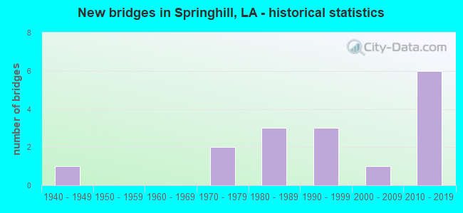
- New bridges - historical statistics
- 11940-1949
- 21970-1979
- 31980-1989
- 31990-1999
- 12000-2009
- 62010-2019

- Bridge Condition - Deck
- 54.5%Very good
- 27.3%Good
- 18.2%Fair
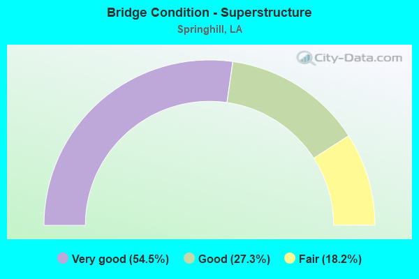
- Bridge Condition - Superstructure
- 54.5%Very good
- 27.3%Good
- 18.2%Fair
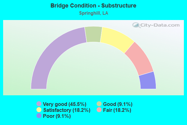
- Bridge Condition - Substructure
- 45.5%Very good
- 9.1%Good
- 18.2%Satisfactory
- 18.2%Fair
- 9.1%Poor
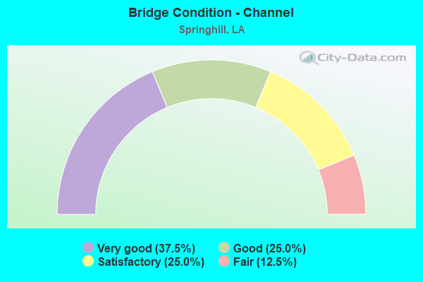
- Bridge Condition - Channel
- 37.5%Very good
- 25.0%Good
- 25.0%Satisfactory
- 12.5%Fair
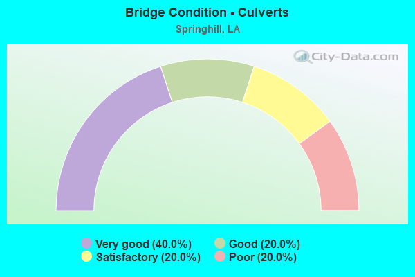
- Bridge Condition - Culverts
- 40.0%Very good
- 20.0%Good
- 20.0%Satisfactory
- 20.0%Poor
Find on map >> Show street view
Structure Number: 46000000040266, Location: 4.1 MILES EAST OF US 371 (Lat: 32.994600, Lng: -93.403600), Route carried "on" structure: State highway 157, Year Built: 2010, Status: Open, Structure Length: 3.66m (12.01ft), Average Daily Traffic: 3,400 (year 2016), Truck Traffic: 19%, Average Future Daily Traffic: 2,040 (year 2036), Design Load: HS 20, Features Intersected: DORCHEAT B. RELIEF
Minimum Vertical Clearance: 30+ m (98+ ft), Kilometerpoint: 6.510, Lanes on structure: 2, Owner: State Highway Agency, Approaching Roadway Width: 13.7m (44.9ft), Skew: 30 degrees, Material/Design: Concrete, Design/Construction: Slab, Number Of Spans In Main Unit: 6, Length of Maximum Span: 6.1m (20.0ft), Curb-To-Curb Width: 13.3m (43.6ft), Out-to-Out Width: 14.1m (46.3ft)
Condition: Deck: Very good, Superstructure: Very good, Substructure: Very good, Channel: Very good, Operating Rating: 38.9 metric tons, Method Used To Determine Operating Rating: Load and Resistance Factor Rating (LRFR) rating reported by rating factor(RF) method using HL-93 loadings, Inventory Rating: 29.8 metric tons, Method Used To Determine Inventory Rating: Load and Resistance Factor Rating (LRFR) rating reported by rating factor(RF) method using HL-93 loadings, Structural Evaluation: Better than present minimum criteria, Deck Geometry: Equal to present minimum criteria, Waterway Adequacy: Equal to present desirable criteria, Approach Roadway Alignment: Equal to present desirable criteria, Designated Inspection Frequency: Every 24 months, Inspection Date: September 2020, Deck Structure Type: Concrete Cast-file-Place, Wearing Surface/Protective System: Wearing Surface: Monolithic Concrete
Find on map >> Show street view
Structure Number: 46000000040267, Location: 6.90 MILES EAST OF US 371 (Lat: 32.976069, Lng: -93.363400), Route carried "on" structure: State highway 157, Year Built: 2010, Status: Open, Structure Length: 9.14m (29.99ft), Average Daily Traffic: 1,900 (year 2016), Truck Traffic: 19%, Average Future Daily Traffic: 1,128 (year 2036), Design Load: HS 20, Features Intersected: CYPRESS CREEK
Minimum Vertical Clearance: 30+ m (98+ ft), Kilometerpoint: 10.981, Lanes on structure: 2, Owner: State Highway Agency, Approaching Roadway Width: 13.7m (44.9ft), Skew: 30 degrees, Material/Design: Concrete, Design/Construction: Slab, Number Of Spans In Main Unit: 15, Length of Maximum Span: 6.1m (20.0ft), Curb-To-Curb Width: 13.3m (43.6ft), Out-to-Out Width: 14.3m (46.9ft)
Condition: Deck: Very good, Superstructure: Very good, Substructure: Very good, Channel: Good, Operating Rating: 38.9 metric tons, Method Used To Determine Operating Rating: Load and Resistance Factor Rating (LRFR) rating reported by rating factor(RF) method using HL-93 loadings, Inventory Rating: 29.8 metric tons, Method Used To Determine Inventory Rating: Load and Resistance Factor Rating (LRFR) rating reported by rating factor(RF) method using HL-93 loadings, Structural Evaluation: Better than present minimum criteria, Deck Geometry: Better than present minimum criteria, Waterway Adequacy: Equal to present desirable criteria, Approach Roadway Alignment: Equal to present desirable criteria, Designated Inspection Frequency: Every 24 months, Inspection Date: September 2020, Deck Structure Type: Concrete Cast-file-Place, Wearing Surface/Protective System: Wearing Surface: Monolithic Concrete
Find on map >> Show street view
Structure Number: 46000000040268, Location: 4.35 MILES EAST OF US 371 (Lat: 32.994250, Lng: -93.399300), Route carried "on" structure: State highway 157, Year Built: 2010, Status: Open, Structure Length: 6.10m (20.01ft), Average Daily Traffic: 3,400 (year 2016), Truck Traffic: 19%, Average Future Daily Traffic: 2,040 (year 2036), Design Load: HS 20, Features Intersected: DORCHEAT B. RELIEF
Minimum Vertical Clearance: 30+ m (98+ ft), Kilometerpoint: 6.915, Lanes on structure: 2, Owner: State Highway Agency, Approaching Roadway Width: 13.7m (44.9ft), Skew: 30 degrees, Material/Design: Concrete, Design/Construction: Slab, Number Of Spans In Main Unit: 10, Length of Maximum Span: 6.1m (20.0ft), Curb-To-Curb Width: 13.3m (43.6ft), Out-to-Out Width: 14.2m (46.6ft)
Condition: Deck: Very good, Superstructure: Very good, Substructure: Very good, Channel: Very good, Operating Rating: 38.9 metric tons, Method Used To Determine Operating Rating: Load and Resistance Factor Rating (LRFR) rating reported by rating factor(RF) method using HL-93 loadings, Inventory Rating: 29.8 metric tons, Method Used To Determine Inventory Rating: Load and Resistance Factor Rating (LRFR) rating reported by rating factor(RF) method using HL-93 loadings, Structural Evaluation: Better than present minimum criteria, Deck Geometry: Equal to present minimum criteria, Waterway Adequacy: Equal to present desirable criteria, Approach Roadway Alignment: Equal to present desirable criteria, Designated Inspection Frequency: Every 24 months, Inspection Date: September 2020, Deck Structure Type: Concrete Cast-file-Place, Wearing Surface/Protective System: Wearing Surface: Monolithic Concrete
Find on map >> Show street view
Structure Number: 46000000040269, Location: 4.48 MILES EAST OF US 371 (Lat: 32.994081, Lng: -93.397100), Route carried "on" structure: State highway 157, Year Built: 2010, Status: Open, Structure Length: 13.72m (45.01ft), Average Daily Traffic: 3,400 (year 2016), Truck Traffic: 19%, Average Future Daily Traffic: 2,040 (year 2036), Design Load: HS 20, Features Intersected: DORCHEAT BAYOU
Minimum Vertical Clearance: 30+ m (98+ ft), Kilometerpoint: 7.121, Lanes on structure: 2, Owner: State Highway Agency, Approaching Roadway Width: 13.7m (44.9ft), Skew: 30 degrees, Material/Design: Prestressed concrete continuous, Design/Construction: Stringer/Multi-beam, Number Of Spans In Main Unit: 9, Length of Maximum Span: 15.2m (49.9ft), Curb-To-Curb Width: 13.3m (43.6ft), Out-to-Out Width: 14.2m (46.6ft)
Condition: Deck: Very good, Superstructure: Very good, Substructure: Good, Channel: Very good, Operating Rating: 49.6 metric tons, Method Used To Determine Operating Rating: Load and Resistance Factor Rating (LRFR) rating reported by rating factor(RF) method using HL-93 loadings, Inventory Rating: 38.2 metric tons, Method Used To Determine Inventory Rating: Load and Resistance Factor Rating (LRFR) rating reported by rating factor(RF) method using HL-93 loadings, Structural Evaluation: Better than present minimum criteria, Deck Geometry: Equal to present minimum criteria, Waterway Adequacy: Equal to present desirable criteria, Approach Roadway Alignment: Equal to present desirable criteria, Designated Inspection Frequency: Every 24 months, Underwater Inspection Frequency: Every 60 months, Inspection Date: September 2020, Underwater Inspection Date: June 2020, Deck Structure Type: Concrete Cast-file-Place, Wearing Surface/Protective System: Wearing Surface: Monolithic Concrete
Find on map >> Show street view
Structure Number: 46000000040437, Location: 1.6 MI. S. OF LA 157 (Lat: 32.972831, Lng: -93.411289), Route carried "on" structure: County highway , Year Built: 2016, Status: Open, Structure Length: 1.83m (6.00ft), Average Daily Traffic: 170 (year 2016), Truck Traffic: 1%, Average Future Daily Traffic: 260 (year 2035), Design Load: Greater than HL93, Features Intersected: BRALY CREEK, Facility Carried by Structure: SMITHVILLE RD
Minimum Vertical Clearance: 30+ m (98+ ft), Kilometerpoint: 2.575, Lanes on structure: 2, Base Highway Network: Yes, Owner: County Highway Agency, Approaching Roadway Width: 5.8m (19.0ft), Material/Design: Concrete, Design/Construction: Slab, Number Of Spans In Main Unit: 3, Length of Maximum Span: 6.1m (20.0ft), Curb-To-Curb Width: 7.3m (24.0ft), Out-to-Out Width: 8.2m (26.9ft)
Condition: Deck: Very good, Superstructure: Very good, Substructure: Very good, Channel: Very good, Operating Rating: 59.9 metric tons, Method Used To Determine Operating Rating: Load and Resistance Factor Rating (LRFR) rating reported by rating factor(RF) method using HL-93 loadings, Inventory Rating: 46.3 metric tons, Method Used To Determine Inventory Rating: Load and Resistance Factor Rating (LRFR) rating reported by rating factor(RF) method using HL-93 loadings, Structural Evaluation: Equal to present desirable criteria, Deck Geometry: Somewhat better than minimum adequacy, Waterway Adequacy: Equal to present desirable criteria, Approach Roadway Alignment: Equal to present desirable criteria, Designated Inspection Frequency: Every 24 months, Inspection Date: July 2021, Deck Structure Type: Concrete Cast-file-Place
Find on map >> Show street view
Structure Number: 46000000300929, Location: 0.77 MI EAST OF US 371 (Lat: 33.011400, Lng: -93.459731), Route carried "on" structure: County highway , Year Built: 2011, Status: Open, Structure Length: 0.70m (2.30ft), Average Daily Traffic: 650 (year 2020), Truck Traffic: 3%, Average Future Daily Traffic: 390 (year 2036), Design Load: HS 20, Features Intersected: LITTLE CROOKED CREEK, Facility Carried by Structure: North Giles St
Minimum Vertical Clearance: 30+ m (98+ ft), Kilometerpoint: 0.000, Lanes on structure: 2, Owner: City or Municipal Highway Agency, Approaching Roadway Width: 6.1m (20.0ft), Skew: 31 degrees, Material/Design: Concrete, Design/Construction: Culvert, Number Of Spans In Main Unit: 2, Length of Maximum Span: 3.0m (9.8ft), Curb-To-Curb Width: 7.6m (24.9ft), Out-to-Out Width: 13.5m (44.3ft)
Condition: Channel: Good, Culverts: Very good, Operating Rating: 64.5 metric tons, Method Used To Determine Operating Rating: Load and Resistance Factor Rating (LRFR) rating reported by rating factor(RF) method using HL-93 loadings, Inventory Rating: 49.6 metric tons, Method Used To Determine Inventory Rating: Load and Resistance Factor Rating (LRFR) rating reported by rating factor(RF) method using HL-93 loadings, Structural Evaluation: Equal to present desirable criteria, Deck Geometry: Meets minimum limits, Waterway Adequacy: Better than present minimum criteria, Approach Roadway Alignment: Equal to present minimum criteria, Designated Inspection Frequency: Every 24 months, Inspection Date: July 2021, Deck Structure Type: Other
Find on map >> Show street view
Structure Number: 46000840200031, Location: 3.23 MI WEST OF US371 (Lat: 33.004231, Lng: -93.517200), Route carried "on" structure: State highway 157, Year Built: 1994, Status: Open, Structure Length: 13.72m (45.01ft), Average Daily Traffic: 2,100 (year 2016), Truck Traffic: 19%, Average Future Daily Traffic: 1,260 (year 2036), Design Load: HS 20, Features Intersected: BODCAV BAYOU
Minimum Vertical Clearance: 30+ m (98+ ft), Kilometerpoint: 0.000, Lanes on structure: 2, Owner: State Highway Agency, Approaching Roadway Width: 13.7m (44.9ft), Material/Design: Prestressed concrete, Design/Construction: Stringer/Multi-beam, Number Of Spans In Main Unit: 9, Length of Maximum Span: 15.2m (49.9ft), Curb-To-Curb Width: 13.4m (44.0ft), Out-to-Out Width: 14.3m (46.9ft)
Condition: Deck: Very good, Superstructure: Very good, Substructure: Very good, Channel: Very good, Operating Rating: 75.3 metric tons, Method Used To Determine Operating Rating: Load Factor (LF), Inventory Rating: 35.4 metric tons, Method Used To Determine Inventory Rating: Load Factor (LF), Structural Evaluation: Equal to present desirable criteria, Deck Geometry: Better than present minimum criteria, Waterway Adequacy: Equal to present desirable criteria, Approach Roadway Alignment: Equal to present desirable criteria, Designated Inspection Frequency: Every 24 months, Inspection Date: September 2020, Deck Structure Type: Concrete Cast-file-Place
Find on map >> Show street view
Structure Number: 46000840300661, Location: .66 MI EAST OF US 371 (Lat: 33.002211, Lng: -93.460000), Route carried "on" structure: State highway 157, Year Built: 1977, Status: Open, Structure Length: 1.74m (5.71ft), Average Daily Traffic: 5,100 (year 2016), Truck Traffic: 22%, Average Future Daily Traffic: 3,060 (year 2036), Design Load: HS 20, Features Intersected: CREEK
Minimum Vertical Clearance: 30+ m (98+ ft), Kilometerpoint: 1.020, Lanes on structure: 2, Owner: State Highway Agency, Approaching Roadway Width: 11.3m (37.1ft), Material/Design: Concrete, Design/Construction: Slab, Number Of Spans In Main Unit: 3, Length of Maximum Span: 5.8m (19.0ft), Curb-To-Curb Width: 12.3m (40.4ft), Out-to-Out Width: 13.1m (43.0ft)
Condition: Deck: Fair, Superstructure: Fair, Substructure: Fair, Channel: Fair, Operating Rating: 31.1 metric tons, Method Used To Determine Operating Rating: Load and Resistance Factor Rating (LRFR) rating reported by rating factor(RF) method using HL-93 loadings, Inventory Rating: 24.0 metric tons, Method Used To Determine Inventory Rating: Load and Resistance Factor Rating (LRFR) rating reported by rating factor(RF) method using HL-93 loadings, Structural Evaluation: Somewhat better than minimum adequacy, Deck Geometry: Somewhat better than minimum adequacy, Waterway Adequacy: Better than present minimum criteria, Approach Roadway Alignment: Equal to present desirable criteria, Designated Inspection Frequency: Every 24 months, Inspection Date: August 2021, Deck Structure Type: Concrete Precast Panels, Wearing Surface/Protective System: Wearing Surface: Bituminous
Find on map >> Show street view
Structure Number: 46000840302831, Location: 2.83 MI EAST OF US 371 (Lat: 32.997939, Lng: -93.423400), Route carried "on" structure: State highway 157, Year Built: 1978, Status: Open, Structure Length: 2.32m (7.61ft), Average Daily Traffic: 3,400 (year 2016), Truck Traffic: 19%, Average Future Daily Traffic: 2,040 (year 2036), Design Load: HS 20, Features Intersected: LITTLE CROOKED CREEK
Minimum Vertical Clearance: 30+ m (98+ ft), Kilometerpoint: 4.538, Lanes on structure: 2, Owner: State Highway Agency, Approaching Roadway Width: 10.7m (35.1ft), Material/Design: Concrete, Design/Construction: Slab, Number Of Spans In Main Unit: 4, Length of Maximum Span: 5.8m (19.0ft), Curb-To-Curb Width: 9.9m (32.5ft), Out-to-Out Width: 10.7m (35.1ft)
Condition: Deck: Good, Superstructure: Good, Substructure: Satisfactory, Channel: Satisfactory, Operating Rating: 59.0 metric tons, Method Used To Determine Operating Rating: Load Factor (LF), Inventory Rating: 35.4 metric tons, Method Used To Determine Inventory Rating: Load Factor (LF), Structural Evaluation: Equal to present minimum criteria, Deck Geometry: Meets minimum limits, Waterway Adequacy: Equal to present desirable criteria, Approach Roadway Alignment: Equal to present minimum criteria, Designated Inspection Frequency: Every 24 months, Inspection Date: September 2020, Deck Structure Type: Concrete Precast Panels, Wearing Surface/Protective System: Wearing Surface: Bituminous
Find on map >> Show street view
Structure Number: 46000863000191, Location: .19 MI NORTH OF US 371 (Lat: 32.997000, Lng: -93.461100), Route carried "on" structure: State highway 803, Year Built: 1949, Status: Open, Structure Length: 0.67m (2.20ft), Average Daily Traffic: 5,200 (year 2016), Truck Traffic: 22%, Average Future Daily Traffic: 3,120 (year 2036), Design Load: HS 20, Features Intersected: LITTLE CROOKED CR
Minimum Vertical Clearance: 30+ m (98+ ft), Kilometerpoint: 0.325, Lanes on structure: 2, Owner: State Highway Agency, Approaching Roadway Width: 18.0m (59.1ft), Skew: 30 degrees, Material/Design: Concrete, Design/Construction: Culvert, Number Of Spans In Main Unit: 4, Length of Maximum Span: 1.5m (4.9ft), Curb-To-Curb Width: 11.7m (38.4ft), Out-to-Out Width: 12.1m (39.7ft)
Condition: Channel: Satisfactory, Culverts: Satisfactory, Operating Rating: 27.2 metric tons, Method Used To Determine Operating Rating: Load and Resistance Factor Rating (LRFR) rating reported by rating factor(RF) method using HL-93 loadings, Inventory Rating: 21.1 metric tons, Method Used To Determine Inventory Rating: Load and Resistance Factor Rating (LRFR) rating reported by rating factor(RF) method using HL-93 loadings, Structural Evaluation: Somewhat better than minimum adequacy, Deck Geometry: Somewhat better than minimum adequacy, Waterway Adequacy: Equal to present desirable criteria, Approach Roadway Alignment: Equal to present desirable criteria, Designated Inspection Frequency: Every 24 months, Inspection Date: September 2021, Deck Structure Type: Concrete Cast-file-Place
Find on map >> Show street view
Structure Number: 46032508931531, Location: 0.20 MI W OF LA 159 (Lat: 32.847261, Lng: -93.255450), Route carried "on" structure: County highway , Year Built: 2001, Status: Open, Structure Length: 0.67m (2.20ft), Average Daily Traffic: 110 (year 2020), Average Future Daily Traffic: 60 (year 2036), Design Load: HS 20, Features Intersected: TRIBUTARY TO BLACK BAYOU, Facility Carried by Structure: Evergreen Rd
Minimum Vertical Clearance: 30+ m (98+ ft), Kilometerpoint: 0.000, Lanes on structure: 2, Base Highway Network: Yes, Owner: County Highway Agency, Approaching Roadway Width: 6.1m (20.0ft), Skew: 30 degrees, Material/Design: Concrete, Design/Construction: Culvert, Number Of Spans In Main Unit: 3, Length of Maximum Span: 2.1m (6.9ft)
Condition: Channel: Very good, Culverts: Very good, Operating Rating: 42.1 metric tons, Method Used To Determine Operating Rating: Load and Resistance Factor Rating (LRFR) rating reported by rating factor(RF) method using HL-93 loadings, Inventory Rating: 32.4 metric tons, Method Used To Determine Inventory Rating: Load and Resistance Factor Rating (LRFR) rating reported by rating factor(RF) method using HL-93 loadings, Structural Evaluation: Equal to present desirable criteria, Waterway Adequacy: Equal to present desirable criteria, Approach Roadway Alignment: Equal to present desirable criteria, Designated Inspection Frequency: Every 24 months, Inspection Date: July 2021, Deck Structure Type: Concrete Cast-file-Place
Find on map >> Show street view
Structure Number: 46032596932721, Location: 0.5 MI EAST OF LA 7 (Lat: 32.994781, Lng: -93.454400), Route carried "on" structure: County highway , Year Built: 1985, Status: Open, Structure Length: 1.74m (5.71ft), Average Daily Traffic: 1,750 (year 2020), Average Future Daily Traffic: 1,050 (year 2036), Design Load: HS 20, Features Intersected: LITTLE CROOKED CREEK, Facility Carried by Structure: 7th St
Minimum Vertical Clearance: 30+ m (98+ ft), Kilometerpoint: 0.000, Lanes on structure: 2, Owner: City or Municipal Highway Agency, Approaching Roadway Width: 10.7m (35.1ft), Material/Design: Concrete, Design/Construction: Slab, Number Of Spans In Main Unit: 3, Length of Maximum Span: 5.8m (19.0ft), Curb or Sidewalk Widths: Left: 0.0m, Right: 1.6m (5.2ft), Curb-To-Curb Width: 9.8m (32.2ft), Out-to-Out Width: 11.7m (38.4ft)
Condition: Deck: Good, Superstructure: Good, Substructure: Satisfactory, Channel: Good, Operating Rating: 29.8 metric tons, Method Used To Determine Operating Rating: Load and Resistance Factor Rating (LRFR) rating reported by rating factor(RF) method using HL-93 loadings, Inventory Rating: 23.0 metric tons, Method Used To Determine Inventory Rating: Load and Resistance Factor Rating (LRFR) rating reported by rating factor(RF) method using HL-93 loadings, Structural Evaluation: Equal to present minimum criteria, Deck Geometry: Somewhat better than minimum adequacy, Waterway Adequacy: Equal to present desirable criteria, Approach Roadway Alignment: Equal to present minimum criteria, Designated Inspection Frequency: Every 24 months, Inspection Date: July 2021, Deck Structure Type: Concrete Cast-file-Place
Find on map >> Show street view
Structure Number: 46032598932751, Location: 0.08M EAST OF LA 803-1 (Lat: 32.997931, Lng: -93.459769), Route carried "on" structure: County highway , Year Built: 1990, Status: Posted for load, Structure Length: 1.01m (3.31ft), Average Daily Traffic: 1,250 (year 2020), Average Future Daily Traffic: 750 (year 2036), Design Load: H 10, Features Intersected: LITTLE CROOKED CREEK, Facility Carried by Structure: Legion St
Minimum Vertical Clearance: 30+ m (98+ ft), Kilometerpoint: 0.000, Lanes on structure: 2, Owner: City or Municipal Highway Agency, Approaching Roadway Width: 8.5m (27.9ft), Material/Design: Wood or Timber, Design/Construction: Stringer/Multi-beam, Number Of Spans In Main Unit: 3, Length of Maximum Span: 3.4m (11.2ft), Curb or Sidewalk Widths: Left: 0.0m, Right: 0.9m (3.0ft), Curb-To-Curb Width: 8.4m (27.6ft), Out-to-Out Width: 9.9m (32.5ft)
Condition: Deck: Fair, Superstructure: Fair, Substructure: Poor, Channel: Satisfactory, Operating Rating: 7.3 metric tons, Method Used To Determine Operating Rating: Allowable Stress (AS), Inventory Rating: 4.5 metric tons, Method Used To Determine Inventory Rating: Allowable Stress (AS), Structural Evaluation: High priority of replacement, Deck Geometry: Meets minimum limits, Waterway Adequacy: Equal to present desirable criteria, Approach Roadway Alignment: Equal to present desirable criteria, Bridge Posting: Required (Relationship of Operating Rating to Maximum Legal Load: > 39.9% below), Length Of Structure Improvement: 1.65m (5.41ft), Designated Inspection Frequency: Every 24 months, Other Special Inspection Frequency: Every 6 months, Inspection Date: July 2021, Other Special Inspection Date: January 2022, Bridge Improvement Cost: $98,000, Total Project Cost: $147,000 ( Estimate for 2016), Deck Structure Type: Wood or Timber, Wearing Surface/Protective System: Wearing Surface: Monolithic Concrete
Find on map >> Show street view
Structure Number: 46033002932751, Location: 0.1 MI NORTH OF LA 157 (Lat: 33.003161, Lng: -93.458639), Route carried "on" structure: County highway , Year Built: 1996, Status: Open, Structure Length: 0.64m (2.10ft), Average Daily Traffic: 1,500 (year 2020), Average Future Daily Traffic: 900 (year 2036), Design Load: HS 20, Features Intersected: LITTLE CROOKED CREEK, Facility Carried by Structure: 3rd St
Minimum Vertical Clearance: 30+ m (98+ ft), Kilometerpoint: 0.000, Lanes on structure: 2, Owner: City or Municipal Highway Agency, Approaching Roadway Width: 11.9m (39.0ft), Material/Design: Concrete, Design/Construction: Culvert, Number Of Spans In Main Unit: 2, Length of Maximum Span: 3.0m (9.8ft), Curb-To-Curb Width: 11.9m (39.0ft), Out-to-Out Width: 20.6m (67.6ft)
Condition: Channel: Good, Culverts: Good, Operating Rating: 42.1 metric tons, Method Used To Determine Operating Rating: Load and Resistance Factor Rating (LRFR) rating reported by rating factor(RF) method using HL-93 loadings, Inventory Rating: 32.4 metric tons, Method Used To Determine Inventory Rating: Load and Resistance Factor Rating (LRFR) rating reported by rating factor(RF) method using HL-93 loadings, Structural Evaluation: Better than present minimum criteria, Deck Geometry: Equal to present minimum criteria, Waterway Adequacy: Better than present minimum criteria, Approach Roadway Alignment: Equal to present desirable criteria, Designated Inspection Frequency: Every 24 months, Inspection Date: July 2021, Deck Structure Type: Concrete Cast-file-Place
Find on map >> Show street view
Structure Number: 46033003932591, Location: 0.27 MI EAST OF LA 157 (Lat: 33.005881, Lng: -93.457169), Route carried "on" structure: County highway , Year Built: 1988, Status: Open, Structure Length: 0.88m (2.89ft), Average Daily Traffic: 1,500 (year 2020), Average Future Daily Traffic: 900 (year 2036), Design Load: HS 20, Features Intersected: LITTLE CROOKED CREEK, Facility Carried by Structure: Machen St
Minimum Vertical Clearance: 30+ m (98+ ft), Kilometerpoint: 0.000, Lanes on structure: 2, Owner: City or Municipal Highway Agency, Approaching Roadway Width: 8.8m (28.9ft), Skew: 1 degrees, Material/Design: Steel, Design/Construction: Culvert, Number Of Spans In Main Unit: 4, Length of Maximum Span: 2.1m (6.9ft), Curb-To-Curb Width: 7.0m (23.0ft), Out-to-Out Width: 8.4m (27.6ft)
Condition: Channel: Satisfactory, Culverts: Poor, Operating Rating: 97.2 metric tons, Method Used To Determine Operating Rating: Load and Resistance Factor Rating (LRFR) rating reported by rating factor(RF) method using HL-93 loadings, Inventory Rating: 74.5 metric tons, Method Used To Determine Inventory Rating: Load and Resistance Factor Rating (LRFR) rating reported by rating factor(RF) method using HL-93 loadings, Structural Evaluation: Meets minimum limits, Deck Geometry: High priority of corrective action, Waterway Adequacy: Equal to present desirable criteria, Approach Roadway Alignment: Equal to present desirable criteria, Length Of Structure Improvement: 1.49m (4.89ft), Designated Inspection Frequency: Every 24 months, Other Special Inspection Frequency: Every 12 months, Inspection Date: July 2021, Bridge Improvement Cost: $89,000, Total Project Cost: $133,000 ( Estimate for 2016)
Find on map >> Show street view
Structure Number: 46033005932751, Location: 1.0 MI. E. OF LA. 7 (Lat: 33.008731, Lng: -93.458131), Route carried "on" structure: County highway , Year Built: 1983, Status: Open, Structure Length: 1.74m (5.71ft), Average Daily Traffic: 360 (year 2020), Average Future Daily Traffic: 216 (year 2036), Design Load: HS 20, Features Intersected: TRIB TO CROOKED CREEK, Facility Carried by Structure: Spring Branch Rd
Minimum Vertical Clearance: 30+ m (98+ ft), Kilometerpoint: 0.000, Lanes on structure: 2, Owner: City or Municipal Highway Agency, Approaching Roadway Width: 9.4m (30.8ft), Material/Design: Concrete, Design/Construction: Slab, Number Of Spans In Main Unit: 3, Length of Maximum Span: 5.8m (19.0ft), Curb-To-Curb Width: 8.7m (28.5ft), Out-to-Out Width: 9.4m (30.8ft)
Condition: Deck: Good, Superstructure: Good, Substructure: Fair, Channel: Fair, Operating Rating: 45.4 metric tons, Method Used To Determine Operating Rating: Load and Resistance Factor Rating (LRFR) rating reported by rating factor(RF) method using HL-93 loadings, Inventory Rating: 35.0 metric tons, Method Used To Determine Inventory Rating: Load and Resistance Factor Rating (LRFR) rating reported by rating factor(RF) method using HL-93 loadings, Structural Evaluation: Somewhat better than minimum adequacy, Deck Geometry: Equal to present minimum criteria, Waterway Adequacy: Equal to present desirable criteria, Approach Roadway Alignment: Better than present minimum criteria, Designated Inspection Frequency: Every 24 months, Inspection Date: July 2021, Deck Structure Type: Concrete Cast-file-Place