Bridge Statistics for Springfield, South Carolina (SC)
Condition, Traffic, Stress, Structural Evaluation, Project Costs
- National Bridge Inventory (NBI) Statistics
- 22Number of bridges
- 243ft / 73.7mTotal length
- $1,514,000Total costs
- 25,925Total average daily traffic
- 3,839Total average daily truck traffic
- 40,650Total future (year 2040) average daily traffic
- National Bridge Inventory (NBI) Registered Bridges for Springfield
- No street view available for this location
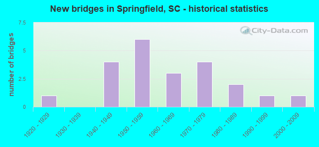
- New bridges - historical statistics
- 11920-1929
- 41940-1949
- 61950-1959
- 31960-1969
- 41970-1979
- 21980-1989
- 11990-1999
- 12000-2009

- Reconstructed bridges - Historical Statistics
- 11930-1939
- 01940-1949
- 01950-1959
- 21960-1969


- Bridge Condition - Deck
- 15.0%Very good
- 35.0%Good
- 40.0%Satisfactory
- 10.0%Fair

- Bridge Condition - Superstructure
- 5.0%Very good
- 45.0%Good
- 35.0%Satisfactory
- 15.0%Fair

- Bridge Condition - Substructure
- 10.0%Very good
- 35.0%Good
- 45.0%Satisfactory
- 10.0%Fair

- Bridge Condition - Channel
- 45.5%Very good
- 50.0%Good
- 4.5%Fair

- Bridge Condition - Culverts
- 50.0%Good
- 50.0%Satisfactory
Find on map >> Show street view
Structure Number: 136, Location: 2MI E OF SPRINGFIELD (Lat: 33.492578, Lng: -81.245322), Route carried "on" structure: State highway 4, Year Built: 1922, Year Reconstructed: 1937, Status: Open, Structure Length: 1.22m (4.00ft), Average Daily Traffic: 1,450 (year 2020), Truck Traffic: 12%, Average Future Daily Traffic: 2,306 (year 2040), Design Load: H 15, Features Intersected: GOODLAND CREEK
Minimum Vertical Clearance: 30+ m (98+ ft), Kilometerpoint: 10.705, Lanes on structure: 2, Base Highway Network: Yes, Owner: State Highway Agency, Approaching Roadway Width: 9.6m (31.5ft), Material/Design: Concrete, Design/Construction: Tee Beam, Number Of Spans In Main Unit: 1, Length of Maximum Span: 12.2m (40.0ft), Curb-To-Curb Width: 7.9m (25.9ft), Out-to-Out Width: 8.7m (28.5ft)
Condition: Deck: Satisfactory, Superstructure: Satisfactory, Substructure: Satisfactory, Channel: Very good, Operating Rating: 48.6 metric tons, Method Used To Determine Operating Rating: Load and Resistance Factor Rating (LRFR) rating reported by rating factor(RF) method using HL-93 loadings, Inventory Rating: 37.6 metric tons, Method Used To Determine Inventory Rating: Load and Resistance Factor Rating (LRFR) rating reported by rating factor(RF) method using HL-93 loadings, Structural Evaluation: Equal to present minimum criteria, Deck Geometry: Meets minimum limits, Waterway Adequacy: Equal to present minimum criteria, Approach Roadway Alignment: Equal to present desirable criteria, Length Of Structure Improvement: 1.22m (4.00ft), Designated Inspection Frequency: Every 24 months, Inspection Date: November 2021, Deck Structure Type: Concrete Cast-file-Place, Wearing Surface/Protective System: Wearing Surface: Bituminous
Find on map >> Show street view
Structure Number: 82, Location: 0.5MI NE OF SPRINGFIELD (Lat: 33.502800, Lng: -81.266614), Route carried "on" structure: Business State highway 3, Year Built: 2002, Status: Open, Structure Length: 3.96m (12.99ft), Average Daily Traffic: 1,100 (year 2021), Truck Traffic: 16%, Average Future Daily Traffic: 1,749 (year 2041), Design Load: HS 20, Features Intersected: GOODLAND CREEK
Minimum Vertical Clearance: 30+ m (98+ ft), Kilometerpoint: 3.705, Lanes on structure: 2, Base Highway Network: Yes, Owner: State Highway Agency, Approaching Roadway Width: 8.3m (27.2ft), Material/Design: Prestressed concrete, Design/Construction: Stringer/Multi-beam, Number Of Spans In Main Unit: 3, Length of Maximum Span: 15.2m (49.9ft), Curb-To-Curb Width: 13.4m (44.0ft), Out-to-Out Width: 14.3m (46.9ft)
Condition: Deck: Very good, Superstructure: Very good, Substructure: Very good, Channel: Very good, Operating Rating: 42.1 metric tons, Method Used To Determine Operating Rating: Load and Resistance Factor Rating (LRFR) rating reported by rating factor(RF) method using HL-93 loadings, Inventory Rating: 30.1 metric tons, Method Used To Determine Inventory Rating: Load and Resistance Factor Rating (LRFR) rating reported by rating factor(RF) method using HL-93 loadings, Structural Evaluation: Better than present minimum criteria, Deck Geometry: Equal to present desirable criteria, Waterway Adequacy: Better than present minimum criteria, Approach Roadway Alignment: Equal to present desirable criteria, Length Of Structure Improvement: 3.96m (12.99ft), Designated Inspection Frequency: Every 24 months, Inspection Date: November 2021, Deck Structure Type: Concrete Cast-file-Place, Wearing Surface/Protective System: Wearing Surface: Monolithic Concrete
Find on map >> Show street view
Structure Number: 1115, Location: 3MI SW OF SPRINGFIELD (Lat: 33.480658, Lng: -81.310561), Route carried "on" structure: State highway 39, Year Built: 1940, Year Reconstructed: 1968, Status: Open, Structure Length: 2.10m (6.89ft), Average Daily Traffic: 2,100 (year 2021), Truck Traffic: 16%, Average Future Daily Traffic: 3,339 (year 2041), Design Load: HS 20, Features Intersected: S. EDISTO RIVER SWAMP
Minimum Vertical Clearance: 30+ m (98+ ft), Kilometerpoint: 0.338, Lanes on structure: 2, Base Highway Network: Yes, Owner: State Highway Agency, Approaching Roadway Width: 7.3m (24.0ft), Material/Design: Concrete, Design/Construction: Tee Beam, Number Of Spans In Main Unit: 3, Length of Maximum Span: 7.0m (23.0ft), Curb-To-Curb Width: 13.4m (44.0ft), Out-to-Out Width: 14.6m (47.9ft)
Condition: Deck: Fair, Superstructure: Fair, Substructure: Satisfactory, Channel: Good, Operating Rating: 25.3 metric tons, Method Used To Determine Operating Rating: Load and Resistance Factor Rating (LRFR) rating reported by rating factor(RF) method using HL-93 loadings, Inventory Rating: 19.4 metric tons, Method Used To Determine Inventory Rating: Load and Resistance Factor Rating (LRFR) rating reported by rating factor(RF) method using HL-93 loadings, Structural Evaluation: Somewhat better than minimum adequacy, Deck Geometry: Better than present minimum criteria, Waterway Adequacy: Equal to present minimum criteria, Approach Roadway Alignment: Equal to present desirable criteria, Bridge Posting: Required (Relationship of Operating Rating to Maximum Legal Load: 10.0 - 19.9% below), Length Of Structure Improvement: 2.10m (6.89ft), Designated Inspection Frequency: Every 24 months, Inspection Date: November 2021, Deck Structure Type: Concrete Cast-file-Place, Wearing Surface/Protective System: Wearing Surface: Bituminous
Find on map >> Show street view
Structure Number: 1116, Location: 16MI S OF ORANGEBURG (Lat: 33.482239, Lng: -81.308736), Route carried "on" structure: State highway 39, Year Built: 1940, Year Reconstructed: 1968, Status: Open, Structure Length: 6.31m (20.70ft), Average Daily Traffic: 2,100 (year 2021), Truck Traffic: 16%, Average Future Daily Traffic: 3,339 (year 2041), Design Load: HS 20, Features Intersected: S. EDISTO RIVER SWAMP
Minimum Vertical Clearance: 30+ m (98+ ft), Kilometerpoint: 0.558, Lanes on structure: 2, Base Highway Network: Yes, Owner: State Highway Agency, Approaching Roadway Width: 7.5m (24.6ft), Material/Design: Concrete, Design/Construction: Tee Beam, Number Of Spans In Main Unit: 9, Length of Maximum Span: 7.0m (23.0ft), Curb-To-Curb Width: 9.1m (29.9ft), Out-to-Out Width: 10.4m (34.1ft)
Condition: Deck: Fair, Superstructure: Fair, Substructure: Satisfactory, Channel: Good, Operating Rating: 25.6 metric tons, Method Used To Determine Operating Rating: Load and Resistance Factor Rating (LRFR) rating reported by rating factor(RF) method using HL-93 loadings, Inventory Rating: 19.8 metric tons, Method Used To Determine Inventory Rating: Load and Resistance Factor Rating (LRFR) rating reported by rating factor(RF) method using HL-93 loadings, Structural Evaluation: Somewhat better than minimum adequacy, Deck Geometry: Meets minimum limits, Waterway Adequacy: Equal to present minimum criteria, Approach Roadway Alignment: Equal to present desirable criteria, Bridge Posting: Required (Relationship of Operating Rating to Maximum Legal Load: 10.0 - 19.9% below), Length Of Structure Improvement: 6.31m (20.70ft), Designated Inspection Frequency: Every 24 months, Inspection Date: November 2021, Deck Structure Type: Concrete Cast-file-Place, Wearing Surface/Protective System: Wearing Surface: Bituminous
Find on map >> Show street view
Structure Number: 1342, Location: 1.5MI S OF ORANGEBURG COL (Lat: 33.459097, Lng: -81.319769), Route carried "on" structure: State highway 37, Year Built: 1947, Status: Open, Structure Length: 1.55m (5.09ft), Average Daily Traffic: 900 (year 2020), Truck Traffic: 10%, Average Future Daily Traffic: 1,314 (year 2040), Design Load: H 15, Features Intersected: SPUR BRANCH
Minimum Vertical Clearance: 30+ m (98+ ft), Kilometerpoint: 23.134, Lanes on structure: 2, Owner: State Highway Agency, Approaching Roadway Width: 7.3m (24.0ft), Material/Design: Concrete, Design/Construction: Culvert, Number Of Spans In Main Unit: 4, Length of Maximum Span: 3.7m (12.1ft), Curb-To-Curb Width: 11.0m (36.1ft), Out-to-Out Width: 11.6m (38.1ft)
Condition: Channel: Good, Culverts: Good, Operating Rating: 31.8 metric tons, Method Used To Determine Operating Rating: Load and Resistance Factor Rating (LRFR) rating reported by rating factor(RF) method using HL-93 loadings, Inventory Rating: 24.3 metric tons, Method Used To Determine Inventory Rating: Load and Resistance Factor Rating (LRFR) rating reported by rating factor(RF) method using HL-93 loadings, Structural Evaluation: Equal to present minimum criteria, Deck Geometry: Better than present minimum criteria, Waterway Adequacy: Equal to present minimum criteria, Approach Roadway Alignment: Equal to present desirable criteria, Length Of Structure Improvement: 1.55m (5.09ft), Designated Inspection Frequency: Every 24 months, Inspection Date: June 2020
Find on map >> Show street view
Structure Number: 1398, Location: 0.5MI E OF SPRINGFIELD (Lat: 33.499144, Lng: -81.262022), Route carried "on" structure: State highway 3, Year Built: 1947, Status: Open, Structure Length: 1.31m (4.30ft), Average Daily Traffic: 2,400 (year 2020), Truck Traffic: 16%, Average Future Daily Traffic: 3,816 (year 2040), Design Load: H 15, Features Intersected: GOODLAND CREEK
Minimum Vertical Clearance: 30+ m (98+ ft), Kilometerpoint: 4.302, Lanes on structure: 2, Base Highway Network: Yes, Owner: State Highway Agency, Approaching Roadway Width: 7.9m (25.9ft), Material/Design: Concrete, Design/Construction: Culvert, Number Of Spans In Main Unit: 4, Length of Maximum Span: 3.0m (9.8ft), Curb-To-Curb Width: 12.4m (40.7ft), Out-to-Out Width: 13.0m (42.7ft)
Condition: Channel: Very good, Culverts: Satisfactory, Operating Rating: 39.2 metric tons, Method Used To Determine Operating Rating: Load and Resistance Factor Rating (LRFR) rating reported by rating factor(RF) method using HL-93 loadings, Inventory Rating: 30.1 metric tons, Method Used To Determine Inventory Rating: Load and Resistance Factor Rating (LRFR) rating reported by rating factor(RF) method using HL-93 loadings, Structural Evaluation: Equal to present minimum criteria, Deck Geometry: Equal to present minimum criteria, Waterway Adequacy: Equal to present minimum criteria, Approach Roadway Alignment: Equal to present desirable criteria, Length Of Structure Improvement: 1.31m (4.30ft), Designated Inspection Frequency: Every 24 months, Inspection Date: November 2021
Find on map >> Show street view
Structure Number: 2131, Location: 6MI N OF BLACKVILLE (Lat: 33.456394, Lng: -81.279686), Route carried "on" structure: State highway 3, Year Built: 1955, Status: Open, Structure Length: 2.93m (9.61ft), Average Daily Traffic: 2,100 (year 2020), Truck Traffic: 17%, Average Future Daily Traffic: 3,339 (year 2040), Design Load: HS 15, Features Intersected: S. EDISTO RIVER SWP
Minimum Vertical Clearance: 30+ m (98+ ft), Kilometerpoint: 43.196, Lanes on structure: 2, Base Highway Network: Yes, Owner: State Highway Agency, Approaching Roadway Width: 7.2m (23.6ft), Material/Design: Concrete, Design/Construction: Tee Beam, Number Of Spans In Main Unit: 3, Length of Maximum Span: 9.8m (32.2ft), Curb or Sidewalk Widths: Left: 0.5m (1.6ft), Right: 0.5m (1.6ft), Curb-To-Curb Width: 7.9m (25.9ft), Out-to-Out Width: 9.4m (30.8ft)
Condition: Deck: Good, Superstructure: Good, Substructure: Very good, Channel: Very good, Operating Rating: 38.9 metric tons, Method Used To Determine Operating Rating: Load and Resistance Factor Rating (LRFR) rating reported by rating factor(RF) method using HL-93 loadings, Inventory Rating: 30.1 metric tons, Method Used To Determine Inventory Rating: Load and Resistance Factor Rating (LRFR) rating reported by rating factor(RF) method using HL-93 loadings, Structural Evaluation: Better than present minimum criteria, Deck Geometry: High priority of corrective action, Waterway Adequacy: Equal to present minimum criteria, Approach Roadway Alignment: Equal to present desirable criteria, Bridge Posting: Required (Relationship of Operating Rating to Maximum Legal Load: 10.0 - 19.9% below), Length Of Structure Improvement: 3.77m (12.37ft), Designated Inspection Frequency: Every 24 months, Inspection Date: June 2020, Bridge Improvement Cost: $171,000, Roadway Improvement Cost: $43,000, Total Project Cost: $257,000 ( Estimate for 2021), Deck Structure Type: Concrete Cast-file-Place, Wearing Surface/Protective System: Wearing Surface: Bituminous
Find on map >> Show street view
Structure Number: 2132, Location: .4MI S OF ORANGEBURG CO L (Lat: 33.461142, Lng: -81.277028), Route carried "on" structure: State highway 3, Year Built: 1955, Status: Open, Structure Length: 4.88m (16.01ft), Average Daily Traffic: 2,100 (year 2020), Truck Traffic: 17%, Average Future Daily Traffic: 3,339 (year 2040), Design Load: HS 15, Features Intersected: S. EDISTO RIVER SWP
Minimum Vertical Clearance: 30+ m (98+ ft), Kilometerpoint: 43.776, Lanes on structure: 2, Base Highway Network: Yes, Owner: State Highway Agency, Approaching Roadway Width: 7.2m (23.6ft), Material/Design: Concrete, Design/Construction: Tee Beam, Number Of Spans In Main Unit: 5, Length of Maximum Span: 9.8m (32.2ft), Curb-To-Curb Width: 7.9m (25.9ft), Out-to-Out Width: 9.0m (29.5ft)
Condition: Deck: Very good, Superstructure: Good, Substructure: Satisfactory, Channel: Very good, Operating Rating: 37.3 metric tons, Method Used To Determine Operating Rating: Load and Resistance Factor Rating (LRFR) rating reported by rating factor(RF) method using HL-93 loadings, Inventory Rating: 28.8 metric tons, Method Used To Determine Inventory Rating: Load and Resistance Factor Rating (LRFR) rating reported by rating factor(RF) method using HL-93 loadings, Structural Evaluation: Equal to present minimum criteria, Deck Geometry: High priority of corrective action, Waterway Adequacy: Equal to present minimum criteria, Approach Roadway Alignment: Equal to present desirable criteria, Bridge Posting: Required (Relationship of Operating Rating to Maximum Legal Load: 20.0 - 29.9% below), Length Of Structure Improvement: 5.80m (19.03ft), Designated Inspection Frequency: Every 24 months, Inspection Date: June 2020, Bridge Improvement Cost: $264,000, Roadway Improvement Cost: $66,000, Total Project Cost: $396,000 ( Estimate for 2021), Deck Structure Type: Concrete Cast-file-Place, Wearing Surface/Protective System: Wearing Surface: Bituminous
Find on map >> Show street view
Structure Number: 2133, Location: 0.1MI S OF ORANGEBURG COL (Lat: 33.462058, Lng: -81.276517), Route carried "on" structure: State highway 3, Year Built: 1955, Status: Open, Structure Length: 4.88m (16.01ft), Average Daily Traffic: 2,100 (year 2020), Truck Traffic: 17%, Average Future Daily Traffic: 3,339 (year 2040), Design Load: HS 15, Features Intersected: S. EDISTO RIVER SWP
Minimum Vertical Clearance: 30+ m (98+ ft), Kilometerpoint: 43.890, Lanes on structure: 2, Base Highway Network: Yes, Owner: State Highway Agency, Approaching Roadway Width: 7.2m (23.6ft), Material/Design: Concrete, Design/Construction: Tee Beam, Number Of Spans In Main Unit: 5, Length of Maximum Span: 9.8m (32.2ft), Curb-To-Curb Width: 7.9m (25.9ft), Out-to-Out Width: 9.0m (29.5ft)
Condition: Deck: Satisfactory, Superstructure: Satisfactory, Substructure: Good, Channel: Very good, Operating Rating: 38.9 metric tons, Method Used To Determine Operating Rating: Load and Resistance Factor Rating (LRFR) rating reported by rating factor(RF) method using HL-93 loadings, Inventory Rating: 29.8 metric tons, Method Used To Determine Inventory Rating: Load and Resistance Factor Rating (LRFR) rating reported by rating factor(RF) method using HL-93 loadings, Structural Evaluation: Equal to present minimum criteria, Deck Geometry: High priority of corrective action, Waterway Adequacy: Equal to present minimum criteria, Approach Roadway Alignment: Equal to present desirable criteria, Bridge Posting: Required (Relationship of Operating Rating to Maximum Legal Load: 10.0 - 19.9% below), Length Of Structure Improvement: 5.80m (19.03ft), Designated Inspection Frequency: Every 24 months, Inspection Date: June 2020, Bridge Improvement Cost: $264,000, Roadway Improvement Cost: $66,000, Total Project Cost: $396,000 ( Estimate for 2021), Deck Structure Type: Concrete Cast-file-Place, Wearing Surface/Protective System: Wearing Surface: Bituminous
Find on map >> Show street view
Structure Number: 2134, Location: ORANGEBURG CO LN (Lat: 33.462881, Lng: -81.276078), Route carried "on" structure: State highway 3, Year Built: 1955, Status: Open, Structure Length: 5.85m (19.19ft), Average Daily Traffic: 2,100 (year 2020), Truck Traffic: 17%, Average Future Daily Traffic: 3,339 (year 2040), Design Load: HS 15, Features Intersected: EDISTO RIVER
Minimum Vertical Clearance: 30+ m (98+ ft), Kilometerpoint: 43.966, Lanes on structure: 2, Base Highway Network: Yes, Owner: State Highway Agency, Approaching Roadway Width: 7.2m (23.6ft), Material/Design: Concrete, Design/Construction: Tee Beam, Number Of Spans In Main Unit: 6, Length of Maximum Span: 9.8m (32.2ft), Curb or Sidewalk Widths: Left: 0.5m (1.6ft), Right: 0.5m (1.6ft), Curb-To-Curb Width: 7.9m (25.9ft), Out-to-Out Width: 8.4m (27.6ft)
Condition: Deck: Very good, Superstructure: Good, Substructure: Good, Channel: Good, Operating Rating: 35.0 metric tons, Method Used To Determine Operating Rating: Load and Resistance Factor Rating (LRFR) rating reported by rating factor(RF) method using HL-93 loadings, Inventory Rating: 27.2 metric tons, Method Used To Determine Inventory Rating: Load and Resistance Factor Rating (LRFR) rating reported by rating factor(RF) method using HL-93 loadings, Structural Evaluation: Equal to present minimum criteria, Deck Geometry: High priority of corrective action, Waterway Adequacy: Equal to present minimum criteria, Approach Roadway Alignment: Equal to present desirable criteria, Bridge Posting: Required (Relationship of Operating Rating to Maximum Legal Load: 20.0 - 29.9% below), Length Of Structure Improvement: 6.82m (22.38ft), Designated Inspection Frequency: Every 24 months, Inspection Date: June 2020, Bridge Improvement Cost: $310,000, Roadway Improvement Cost: $78,000, Total Project Cost: $465,000 ( Estimate for 2021), Deck Structure Type: Concrete Cast-file-Place, Wearing Surface/Protective System: Wearing Surface: Bituminous
Find on map >> Show street view
Structure Number: 2227, Location: 3MI SW OF SPRINGFIELD (Lat: 33.465094, Lng: -81.274828), Route carried "on" structure: State highway 3, Year Built: 1955, Status: Open, Structure Length: 5.85m (19.19ft), Average Daily Traffic: 1,650 (year 2021), Truck Traffic: 13%, Average Future Daily Traffic: 2,624 (year 2041), Design Load: HS 15, Features Intersected: SOUTH EDISTO RIVER SWAMP
Minimum Vertical Clearance: 30+ m (98+ ft), Kilometerpoint: 0.240, Lanes on structure: 2, Base Highway Network: Yes, Owner: State Highway Agency, Approaching Roadway Width: 7.2m (23.6ft), Material/Design: Concrete, Design/Construction: Tee Beam, Number Of Spans In Main Unit: 6, Length of Maximum Span: 9.8m (32.2ft), Curb or Sidewalk Widths: Left: 0.5m (1.6ft), Right: 0.5m (1.6ft), Curb-To-Curb Width: 7.9m (25.9ft), Out-to-Out Width: 8.9m (29.2ft)
Condition: Deck: Satisfactory, Superstructure: Satisfactory, Substructure: Good, Channel: Good, Operating Rating: 34.3 metric tons, Method Used To Determine Operating Rating: Load and Resistance Factor Rating (LRFR) rating reported by rating factor(RF) method using HL-93 loadings, Inventory Rating: 26.6 metric tons, Method Used To Determine Inventory Rating: Load and Resistance Factor Rating (LRFR) rating reported by rating factor(RF) method using HL-93 loadings, Structural Evaluation: Equal to present minimum criteria, Deck Geometry: Meets minimum limits, Waterway Adequacy: Equal to present minimum criteria, Approach Roadway Alignment: Equal to present desirable criteria, Length Of Structure Improvement: 5.85m (19.19ft), Designated Inspection Frequency: Every 24 months, Inspection Date: November 2021, Deck Structure Type: Concrete Cast-file-Place, Wearing Surface/Protective System: Wearing Surface: Bituminous
Find on map >> Show street view
Structure Number: 2228, Location: 3MI SW OF SPRINGFIELD (Lat: 33.467203, Lng: -81.273633), Route carried "on" structure: State highway 3, Year Built: 1955, Status: Open, Structure Length: 5.85m (19.19ft), Average Daily Traffic: 1,650 (year 2021), Truck Traffic: 13%, Average Future Daily Traffic: 2,624 (year 2041), Design Load: H 15, Features Intersected: SOUTH EDISTO RIVER SWAMP
Minimum Vertical Clearance: 30+ m (98+ ft), Kilometerpoint: 0.496, Lanes on structure: 2, Base Highway Network: Yes, Owner: State Highway Agency, Approaching Roadway Width: 7.3m (24.0ft), Material/Design: Concrete, Design/Construction: Tee Beam, Number Of Spans In Main Unit: 6, Length of Maximum Span: 9.8m (32.2ft), Curb or Sidewalk Widths: Left: 0.5m (1.6ft), Right: 0.5m (1.6ft), Curb-To-Curb Width: 7.9m (25.9ft), Out-to-Out Width: 8.8m (28.9ft)
Condition: Deck: Satisfactory, Superstructure: Fair, Substructure: Satisfactory, Channel: Good, Operating Rating: 27.9 metric tons, Method Used To Determine Operating Rating: Load and Resistance Factor Rating (LRFR) rating reported by rating factor(RF) method using HL-93 loadings, Inventory Rating: 21.4 metric tons, Method Used To Determine Inventory Rating: Load and Resistance Factor Rating (LRFR) rating reported by rating factor(RF) method using HL-93 loadings, Structural Evaluation: Somewhat better than minimum adequacy, Deck Geometry: Meets minimum limits, Waterway Adequacy: Equal to present minimum criteria, Approach Roadway Alignment: Equal to present desirable criteria, Bridge Posting: Required (Relationship of Operating Rating to Maximum Legal Load: 0.1 - 9.9% below), Length Of Structure Improvement: 5.85m (19.19ft), Designated Inspection Frequency: Every 24 months, Inspection Date: November 2021, Deck Structure Type: Concrete Cast-file-Place, Wearing Surface/Protective System: Wearing Surface: Bituminous
Find on map >> Show street view
Structure Number: 4046, Location: 6.5 MI N BLACKVILLE (Lat: 33.447169, Lng: -81.293822), Route carried "on" structure: State highway 38, Year Built: 1963, Status: Posted for load, Structure Length: 2.29m (7.51ft), Average Daily Traffic: 175 (year 2020), Truck Traffic: 21%, Average Future Daily Traffic: 256 (year 2040), Design Load: H 10, Features Intersected: WHALEY BRANCH
Minimum Vertical Clearance: 30+ m (98+ ft), Kilometerpoint: 2.618, Lanes on structure: 2, Owner: State Highway Agency, Approaching Roadway Width: 7.3m (24.0ft), Material/Design: Concrete, Design/Construction: Slab, Number Of Spans In Main Unit: 5, Length of Maximum Span: 4.6m (15.1ft), Curb-To-Curb Width: 7.9m (25.9ft), Out-to-Out Width: 8.4m (27.6ft)
Condition: Deck: Satisfactory, Superstructure: Satisfactory, Substructure: Fair, Channel: Very good, Operating Rating: 21.1 metric tons, Method Used To Determine Operating Rating: Load and Resistance Factor Rating (LRFR) rating reported by rating factor(RF) method using HL-93 loadings, Inventory Rating: 16.2 metric tons, Method Used To Determine Inventory Rating: Load and Resistance Factor Rating (LRFR) rating reported by rating factor(RF) method using HL-93 loadings, Structural Evaluation: Somewhat better than minimum adequacy, Deck Geometry: Somewhat better than minimum adequacy, Waterway Adequacy: Better than present minimum criteria, Approach Roadway Alignment: Equal to present desirable criteria, Bridge Posting: Required (Relationship of Operating Rating to Maximum Legal Load: 20.0 - 29.9% below), Length Of Structure Improvement: 2.29m (7.51ft), Designated Inspection Frequency: Every 24 months, Inspection Date: June 2021, Deck Structure Type: Concrete Precast Panels, Wearing Surface/Protective System: Wearing Surface: Bituminous
Find on map >> Show street view
Structure Number: 4047, Location: 6 MI N BLACKVILLE (Lat: 33.442261, Lng: -81.298958), Route carried "on" structure: State highway 192, Year Built: 1963, Status: Open, Structure Length: 1.83m (6.00ft), Average Daily Traffic: 125 (year 2021), Truck Traffic: 5%, Average Future Daily Traffic: 160 (year 2041), Design Load: H 10, Features Intersected: WHALEY BRANCH
Minimum Vertical Clearance: 30+ m (98+ ft), Kilometerpoint: 1.839, Lanes on structure: 2, Owner: State Highway Agency, Approaching Roadway Width: 6.4m (21.0ft), Material/Design: Concrete, Design/Construction: Slab, Number Of Spans In Main Unit: 4, Length of Maximum Span: 4.6m (15.1ft), Curb-To-Curb Width: 7.9m (25.9ft), Out-to-Out Width: 8.4m (27.6ft)
Condition: Deck: Satisfactory, Superstructure: Satisfactory, Substructure: Fair, Channel: Good, Operating Rating: 21.4 metric tons, Method Used To Determine Operating Rating: Load and Resistance Factor Rating (LRFR) rating reported by rating factor(RF) method using HL-93 loadings, Inventory Rating: 16.5 metric tons, Method Used To Determine Inventory Rating: Load and Resistance Factor Rating (LRFR) rating reported by rating factor(RF) method using HL-93 loadings, Structural Evaluation: Somewhat better than minimum adequacy, Deck Geometry: Somewhat better than minimum adequacy, Waterway Adequacy: Better than present minimum criteria, Approach Roadway Alignment: Better than present minimum criteria, Bridge Posting: Required (Relationship of Operating Rating to Maximum Legal Load: 20.0 - 29.9% below), Length Of Structure Improvement: 1.83m (6.00ft), Designated Inspection Frequency: Every 24 months, Inspection Date: June 2021, Deck Structure Type: Concrete Precast Panels, Wearing Surface/Protective System: Wearing Surface: Bituminous
Find on map >> Show street view
Structure Number: 5214, Location: ORANGEBURG CO LN (Lat: 33.478372, Lng: -81.313233), Route carried "on" structure: State highway 39, Year Built: 1968, Status: Open, Structure Length: 10.06m (33.01ft), Average Daily Traffic: 1,400 (year 2020), Truck Traffic: 14%, Average Future Daily Traffic: 2,226 (year 2040), Design Load: HS 20, Features Intersected: SOUTH EDISTO RIVER
Minimum Vertical Clearance: 30+ m (98+ ft), Kilometerpoint: 22.027, Lanes on structure: 2, Base Highway Network: Yes, Owner: State Highway Agency, Approaching Roadway Width: 7.3m (24.0ft), Material/Design: Concrete, Design/Construction: Slab, Number Of Spans In Main Unit: 11, Length of Maximum Span: 9.1m (29.9ft), Curb-To-Curb Width: 9.1m (29.9ft), Out-to-Out Width: 10.5m (34.4ft)
Condition: Deck: Good, Superstructure: Good, Substructure: Good, Channel: Very good, Operating Rating: 40.5 metric tons, Method Used To Determine Operating Rating: Load and Resistance Factor Rating (LRFR) rating reported by rating factor(RF) method using HL-93 loadings, Inventory Rating: 31.4 metric tons, Method Used To Determine Inventory Rating: Load and Resistance Factor Rating (LRFR) rating reported by rating factor(RF) method using HL-93 loadings, Structural Evaluation: Better than present minimum criteria, Deck Geometry: Somewhat better than minimum adequacy, Waterway Adequacy: Equal to present desirable criteria, Approach Roadway Alignment: Equal to present desirable criteria, Length Of Structure Improvement: 10.06m (33.01ft), Designated Inspection Frequency: Every 24 months, Inspection Date: June 2020, Deck Structure Type: Concrete Cast-file-Place, Wearing Surface/Protective System: Wearing Surface: Bituminous
Find on map >> Show street view
Structure Number: 6003, Location: 1MI N SPRINGFIELD (Lat: 33.514119, Lng: -81.268814), Route carried "on" structure: State highway 101, Year Built: 1971, Status: Open, Structure Length: 1.37m (4.49ft), Average Daily Traffic: 100 (year 2021), Truck Traffic: 4%, Average Future Daily Traffic: 128 (year 2041), Design Load: H 10, Features Intersected: GOODLAND CREEK
Minimum Vertical Clearance: 30+ m (98+ ft), Kilometerpoint: 1.442, Lanes on structure: 2, Owner: State Highway Agency, Approaching Roadway Width: 5.5m (18.0ft), Material/Design: Concrete, Design/Construction: Slab, Number Of Spans In Main Unit: 3, Length of Maximum Span: 4.6m (15.1ft), Curb-To-Curb Width: 7.9m (25.9ft), Out-to-Out Width: 8.4m (27.6ft)
Condition: Deck: Satisfactory, Superstructure: Satisfactory, Substructure: Satisfactory, Channel: Very good, Operating Rating: 22.0 metric tons, Method Used To Determine Operating Rating: Load and Resistance Factor Rating (LRFR) rating reported by rating factor(RF) method using HL-93 loadings, Inventory Rating: 17.2 metric tons, Method Used To Determine Inventory Rating: Load and Resistance Factor Rating (LRFR) rating reported by rating factor(RF) method using HL-93 loadings, Structural Evaluation: Somewhat better than minimum adequacy, Deck Geometry: Equal to present minimum criteria, Waterway Adequacy: Better than present minimum criteria, Approach Roadway Alignment: Better than present minimum criteria, Bridge Posting: Required (Relationship of Operating Rating to Maximum Legal Load: 20.0 - 29.9% below), Length Of Structure Improvement: 1.37m (4.49ft), Designated Inspection Frequency: Every 24 months, Inspection Date: November 2020, Deck Structure Type: Concrete Precast Panels, Wearing Surface/Protective System: Wearing Surface: Monolithic Concrete
Find on map >> Show street view
Structure Number: 6176, Location: 5MI N SPRINGFIELD (Lat: 33.537153, Lng: -81.274836), Route carried "on" structure: State highway 132, Year Built: 1972, Status: Open, Structure Length: 1.83m (6.00ft), Average Daily Traffic: 400 (year 2020), Truck Traffic: 5%, Average Future Daily Traffic: 512 (year 2040), Design Load: H 15, Features Intersected: GOODLAND CREEK
Minimum Vertical Clearance: 30+ m (98+ ft), Kilometerpoint: 12.176, Lanes on structure: 2, Owner: State Highway Agency, Approaching Roadway Width: 6.1m (20.0ft), Material/Design: Concrete, Design/Construction: Slab, Number Of Spans In Main Unit: 4, Length of Maximum Span: 4.6m (15.1ft), Curb-To-Curb Width: 9.6m (31.5ft), Out-to-Out Width: 10.1m (33.1ft)
Condition: Deck: Good, Superstructure: Good, Substructure: Satisfactory, Channel: Very good, Operating Rating: 30.1 metric tons, Method Used To Determine Operating Rating: Load and Resistance Factor Rating (LRFR) rating reported by rating factor(RF) method using HL-93 loadings, Inventory Rating: 23.3 metric tons, Method Used To Determine Inventory Rating: Load and Resistance Factor Rating (LRFR) rating reported by rating factor(RF) method using HL-93 loadings, Structural Evaluation: Equal to present minimum criteria, Deck Geometry: Equal to present minimum criteria, Waterway Adequacy: Better than present minimum criteria, Approach Roadway Alignment: Equal to present desirable criteria, Length Of Structure Improvement: 1.83m (6.00ft), Designated Inspection Frequency: Every 24 months, Inspection Date: November 2021, Deck Structure Type: Concrete Precast Panels, Wearing Surface/Protective System: Wearing Surface: Bituminous
Find on map >> Show street view
Structure Number: 6617, Location: 6.5 MI N BARNWELL (Lat: 33.444197, Lng: -81.282331), Route carried "on" structure: State highway 38, Year Built: 1975, Status: Posted for load, Structure Length: 0.91m (2.99ft), Average Daily Traffic: 350 (year 2020), Truck Traffic: 30%, Average Future Daily Traffic: 511 (year 2040), Design Load: H 10, Features Intersected: WINDY HILL CREEK
Minimum Vertical Clearance: 30+ m (98+ ft), Kilometerpoint: 3.745, Lanes on structure: 2, Owner: State Highway Agency, Approaching Roadway Width: 6.6m (21.7ft), Material/Design: Concrete, Design/Construction: Slab, Number Of Spans In Main Unit: 2, Length of Maximum Span: 4.6m (15.1ft), Curb-To-Curb Width: 9.6m (31.5ft), Out-to-Out Width: 10.1m (33.1ft)
Condition: Deck: Satisfactory, Superstructure: Satisfactory, Substructure: Satisfactory, Channel: Fair, Operating Rating: 21.7 metric tons, Method Used To Determine Operating Rating: Load and Resistance Factor Rating (LRFR) rating reported by rating factor(RF) method using HL-93 loadings, Inventory Rating: 16.8 metric tons, Method Used To Determine Inventory Rating: Load and Resistance Factor Rating (LRFR) rating reported by rating factor(RF) method using HL-93 loadings, Structural Evaluation: Somewhat better than minimum adequacy, Deck Geometry: Equal to present minimum criteria, Waterway Adequacy: Better than present minimum criteria, Approach Roadway Alignment: Equal to present desirable criteria, Bridge Posting: Required (Relationship of Operating Rating to Maximum Legal Load: 20.0 - 29.9% below), Length Of Structure Improvement: 0.91m (2.99ft), Designated Inspection Frequency: Every 24 months, Inspection Date: June 2021, Deck Structure Type: Concrete Precast Panels, Wearing Surface/Protective System: Wearing Surface: Bituminous
Find on map >> Show street view
Structure Number: 715, Location: 2MI W OF SPRINGFIELD (Lat: 33.512667, Lng: -81.318067), Route carried "on" structure: State highway 4, Year Built: 1978, Status: Open, Structure Length: 3.66m (12.01ft), Average Daily Traffic: 1,000 (year 2020), Truck Traffic: 9%, Average Future Daily Traffic: 1,590 (year 2040), Design Load: HS 20, Features Intersected: DEAN SWAMP
Minimum Vertical Clearance: 30+ m (98+ ft), Kilometerpoint: 2.773, Lanes on structure: 2, Base Highway Network: Yes, Owner: State Highway Agency, Approaching Roadway Width: 9.6m (31.5ft), Material/Design: Concrete, Design/Construction: Slab, Number Of Spans In Main Unit: 4, Length of Maximum Span: 9.1m (29.9ft), Curb-To-Curb Width: 13.4m (44.0ft), Out-to-Out Width: 14.4m (47.2ft)
Condition: Deck: Good, Superstructure: Good, Substructure: Good, Channel: Good, Operating Rating: 47.3 metric tons, Method Used To Determine Operating Rating: Load and Resistance Factor Rating (LRFR) rating reported by rating factor(RF) method using HL-93 loadings, Inventory Rating: 36.3 metric tons, Method Used To Determine Inventory Rating: Load and Resistance Factor Rating (LRFR) rating reported by rating factor(RF) method using HL-93 loadings, Structural Evaluation: Better than present minimum criteria, Deck Geometry: Superior to present desirable criteria, Waterway Adequacy: Equal to present minimum criteria, Approach Roadway Alignment: Equal to present desirable criteria, Length Of Structure Improvement: 3.66m (12.01ft), Designated Inspection Frequency: Every 24 months, Inspection Date: November 2021, Deck Structure Type: Concrete Cast-file-Place, Wearing Surface/Protective System: Wearing Surface: Bituminous
Find on map >> Show street view
Structure Number: 7397, Location: 3.5MI NE SPRINGFIELD (Lat: 33.528069, Lng: -81.234700), Route carried "on" structure: State highway 71, Year Built: 1980, Status: Open, Structure Length: 1.37m (4.49ft), Average Daily Traffic: 175 (year 2020), Truck Traffic: 5%, Average Future Daily Traffic: 224 (year 2040), Design Load: H 15, Features Intersected: TAMPA CREEK
Minimum Vertical Clearance: 30+ m (98+ ft), Kilometerpoint: 1.595, Lanes on structure: 2, Owner: State Highway Agency, Approaching Roadway Width: 5.6m (18.4ft), Material/Design: Concrete, Design/Construction: Slab, Number Of Spans In Main Unit: 3, Length of Maximum Span: 4.6m (15.1ft), Curb-To-Curb Width: 9.6m (31.5ft), Out-to-Out Width: 10.1m (33.1ft)
Condition: Deck: Good, Superstructure: Good, Substructure: Good, Channel: Good, Operating Rating: 30.8 metric tons, Method Used To Determine Operating Rating: Load and Resistance Factor Rating (LRFR) rating reported by rating factor(RF) method using HL-93 loadings, Inventory Rating: 23.7 metric tons, Method Used To Determine Inventory Rating: Load and Resistance Factor Rating (LRFR) rating reported by rating factor(RF) method using HL-93 loadings, Structural Evaluation: Equal to present minimum criteria, Deck Geometry: Equal to present minimum criteria, Waterway Adequacy: Better than present minimum criteria, Approach Roadway Alignment: Better than present minimum criteria, Length Of Structure Improvement: 1.37m (4.49ft), Designated Inspection Frequency: Every 24 months, Inspection Date: December 2020, Deck Structure Type: Concrete Precast Panels, Wearing Surface/Protective System: Wearing Surface: Monolithic Concrete
Find on map >> Show street view
Structure Number: 7925, Location: 5MI N SPRINGFIELD (Lat: 33.533603, Lng: -81.236169), Route carried "on" structure: State highway 132, Year Built: 1985, Status: Open, Structure Length: 2.29m (7.51ft), Average Daily Traffic: 325 (year 2020), Truck Traffic: 5%, Average Future Daily Traffic: 416 (year 2040), Design Load: H 15, Features Intersected: TAMPA CREEK
Minimum Vertical Clearance: 30+ m (98+ ft), Kilometerpoint: 8.538, Lanes on structure: 2, Owner: State Highway Agency, Approaching Roadway Width: 6.4m (21.0ft), Material/Design: Concrete, Design/Construction: Slab, Number Of Spans In Main Unit: 5, Length of Maximum Span: 4.6m (15.1ft), Curb-To-Curb Width: 9.6m (31.5ft), Out-to-Out Width: 10.1m (33.1ft)
Condition: Deck: Good, Superstructure: Good, Substructure: Good, Channel: Good, Operating Rating: 30.8 metric tons, Method Used To Determine Operating Rating: Load and Resistance Factor Rating (LRFR) rating reported by rating factor(RF) method using HL-93 loadings, Inventory Rating: 23.7 metric tons, Method Used To Determine Inventory Rating: Load and Resistance Factor Rating (LRFR) rating reported by rating factor(RF) method using HL-93 loadings, Structural Evaluation: Equal to present minimum criteria, Deck Geometry: Equal to present minimum criteria, Waterway Adequacy: Better than present minimum criteria, Approach Roadway Alignment: Equal to present minimum criteria, Length Of Structure Improvement: 2.29m (7.51ft), Designated Inspection Frequency: Every 24 months, Inspection Date: December 2020, Deck Structure Type: Concrete Precast Panels, Wearing Surface/Protective System: Wearing Surface: Bituminous
Find on map >> Show street view
Structure Number: 9454, Location: 4MI E SPRINGFIELD (Lat: 33.487650, Lng: -81.225381), Route carried "on" structure: State highway 1167, Year Built: 1999, Status: Open, Structure Length: 1.37m (4.49ft), Average Daily Traffic: 125 (year 2020), Truck Traffic: 5%, Average Future Daily Traffic: 160 (year 2040), Design Load: HS 20, Features Intersected: TRIB TO ROCKY SWAMP CR
Minimum Vertical Clearance: 30+ m (98+ ft), Kilometerpoint: 1.672, Lanes on structure: 2, Owner: State Highway Agency, Approaching Roadway Width: 5.6m (18.4ft), Material/Design: Concrete, Design/Construction: Slab, Number Of Spans In Main Unit: 3, Length of Maximum Span: 4.6m (15.1ft), Curb-To-Curb Width: 10.4m (34.1ft), Out-to-Out Width: 11.7m (38.4ft)
Condition: Deck: Good, Superstructure: Good, Substructure: Satisfactory, Channel: Good, Operating Rating: 49.2 metric tons, Method Used To Determine Operating Rating: Load and Resistance Factor Rating (LRFR) rating reported by rating factor(RF) method using HL-93 loadings, Inventory Rating: 37.9 metric tons, Method Used To Determine Inventory Rating: Load and Resistance Factor Rating (LRFR) rating reported by rating factor(RF) method using HL-93 loadings, Structural Evaluation: Equal to present minimum criteria, Deck Geometry: Better than present minimum criteria, Waterway Adequacy: Better than present minimum criteria, Approach Roadway Alignment: Equal to present desirable criteria, Length Of Structure Improvement: 1.37m (4.49ft), Designated Inspection Frequency: Every 24 months, Inspection Date: December 2020, Deck Structure Type: Concrete Precast Panels, Wearing Surface/Protective System: Wearing Surface: Bituminous