Bridge Statistics for Spring Valley, Illinois (IL)
Condition, Traffic, Stress, Structural Evaluation, Project Costs
- National Bridge Inventory (NBI) Statistics
- 13Number of bridges
- 292ft / 88.6mTotal length
- 84,625Total average daily traffic
- 17,421Total average daily truck traffic
- National Bridge Inventory (NBI) Registered Bridges for Spring Valley
- No street view available for this location
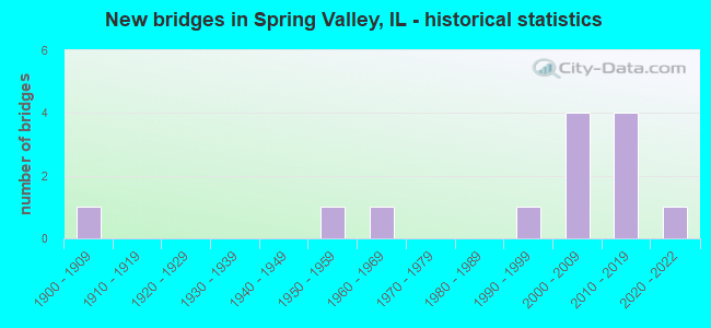
- New bridges - historical statistics
- 11900-1909
- 11950-1959
- 11960-1969
- 11990-1999
- 42000-2009
- 42010-2019
- 12020-2022


- Bridge Condition - Deck
- 14.3%Very good
- 71.4%Good
- 14.3%Poor

- Bridge Condition - Superstructure
- 85.7%Very good
- 14.3%Poor

- Bridge Condition - Substructure
- 85.7%Very good
- 14.3%Fair

- Bridge Condition - Channel
- 11.1%Excellent
- 44.4%Very good
- 22.2%Good
- 11.1%Satisfactory
- 11.1%Poor

- Bridge Condition - Culverts
- 33.3%Excellent
- 66.7%Satisfactory
Find on map >> Show street view
Structure Number: 60158, Location: E EDGE SPRING VALLEY (Lat: 41.327247, Lng: -89.188883), Route carried "on" structure: US 6, Year Built: 1994, Status: Open, Structure Length: 6.25m (20.51ft), Average Daily Traffic: 10,600 (year 2021), Truck Traffic: 15%, Average Future Daily Traffic: 12,897 (year 2032), Design Load: HS 20, Features Intersected: SPRING CR& ABANDN RR
Minimum Vertical Clearance: 30+ m (98+ ft), Kilometerpoint: 127.778, Lanes on structure: 4, Base Highway Network: Yes, Owner: State Highway Agency, Approaching Roadway Width: 22.3m (73.2ft), Skew: 20 degrees, Material/Design: Prestressed concrete, Design/Construction: Stringer/Multi-beam, Number Of Spans In Main Unit: 3, Length of Maximum Span: 25.0m (82.0ft), Curb-To-Curb Width: 21.9m (71.9ft), Out-to-Out Width: 22.9m (75.1ft)
Condition: Deck: Good, Superstructure: Very good, Substructure: Very good, Channel: Good, Operating Rating: 66.7 metric tons, Method Used To Determine Operating Rating: Load Factor (LF) rating reported by rating factor (RF) method using MS18 loading, Inventory Rating: 41.5 metric tons, Method Used To Determine Inventory Rating: Load Factor (LF) rating reported by rating factor (RF) method using MS18 loading, Structural Evaluation: Equal to present desirable criteria, Deck Geometry: Superior to present desirable criteria, Waterway Adequacy: Equal to present desirable criteria, Approach Roadway Alignment: Equal to present desirable criteria, Designated Inspection Frequency: Every 48 months, Inspection Date: March 2019, Deck Structure Type: Concrete Cast-file-Place, Wearing Surface/Protective System: Wearing Surface: Bituminous, Deck Protection: Epoxy Coated Reinforcing
Find on map >> Show street view
Structure Number: 60164, Location: 0.60 MI S OF US 6 (Lat: 41.319050, Lng: -89.199753), Route carried "on" structure: State highway 89, Year Built: 2008, Status: Open, Structure Length: 7.01m (23.00ft), Average Daily Traffic: 4,350 (year 2021), Truck Traffic: 6%, Average Future Daily Traffic: 6,175 (year 2032), Design Load: HS 25 or greater, Features Intersected: RI RAILROAD
Minimum Vertical Clearance: 30+ m (98+ ft), Kilometerpoint: 63.294, Lanes on structure: 2, Base Highway Network: Yes, Owner: State Highway Agency, Approaching Roadway Width: 9.1m (29.9ft), Material/Design: Steel continuous, Design/Construction: Stringer/Multi-beam, Number Of Spans In Main Unit: 3, Length of Maximum Span: 29.9m (98.1ft), Curb or Sidewalk Widths: Left: 0.0m, Right: 1.5m (4.9ft), Curb-To-Curb Width: 9.1m (29.9ft), Out-to-Out Width: 11.5m (37.7ft)
Condition: Deck: Good, Superstructure: Very good, Substructure: Very good, Operating Rating: 81.0 metric tons, Method Used To Determine Operating Rating: Load Factor (LF) rating reported by rating factor (RF) method using MS18 loading, Inventory Rating: 48.6 metric tons, Method Used To Determine Inventory Rating: Load Factor (LF) rating reported by rating factor (RF) method using MS18 loading, Structural Evaluation: Equal to present desirable criteria, Deck Geometry: Meets minimum limits, Underclear: Better than present minimum criteria, Approach Roadway Alignment: Equal to present desirable criteria, Designated Inspection Frequency: Every 48 months, Inspection Date: December 2021, Deck Structure Type: Concrete Cast-file-Place, Wearing Surface/Protective System: Deck Protection: Epoxy Coated Reinforcing
Find on map >> Show street view
Structure Number: 60174, Location: 1.8 MI W IL 89 (Lat: 41.374428, Lng: -89.252411), Route carried "on" structure: Interstate 80, Year Built: 2011, Status: Open, Structure Length: 6.74m (22.11ft), Average Daily Traffic: 11,050 (year 2021), Truck Traffic: 29%, Average Future Daily Traffic: 10,711 (year 2032), Features Intersected: NEGRO CREEK
Minimum Vertical Clearance: 30+ m (98+ ft), Kilometerpoint: 109.980, Lanes on structure: 2, Base Highway Network: Yes, Owner: State Highway Agency, Approaching Roadway Width: 12.2m (40.0ft), Material/Design: Prestressed concrete continuous, Design/Construction: Stringer/Multi-beam, Number Of Spans In Main Unit: 3, Length of Maximum Span: 37.8m (124.0ft), Curb-To-Curb Width: 12.4m (40.7ft), Out-to-Out Width: 13.4m (44.0ft)
Condition: Deck: Good, Superstructure: Very good, Substructure: Very good, Channel: Very good, Operating Rating: 79.7 metric tons, Method Used To Determine Operating Rating: Load Factor (LF) rating reported by rating factor (RF) method using MS18 loading, Inventory Rating: 47.6 metric tons, Method Used To Determine Inventory Rating: Load Factor (LF) rating reported by rating factor (RF) method using MS18 loading, Structural Evaluation: Equal to present desirable criteria, Deck Geometry: Somewhat better than minimum adequacy, Waterway Adequacy: Equal to present desirable criteria, Approach Roadway Alignment: Equal to present desirable criteria, Designated Inspection Frequency: Every 24 months, Inspection Date: March 2020, Deck Structure Type: Concrete Cast-file-Place, Wearing Surface/Protective System: Deck Protection: Epoxy Coated Reinforcing
Find on map >> Show street view
Structure Number: 60175, Location: 1.8 MI W IL 89 (Lat: 41.374361, Lng: -89.252242), Route carried "on" structure: Interstate 80, Year Built: 2010, Status: Open, Structure Length: 6.74m (22.11ft), Average Daily Traffic: 11,050 (year 2021), Truck Traffic: 29%, Average Future Daily Traffic: 10,711 (year 2032), Design Load: HS 20+Mod, Features Intersected: NEGRO CREEK
Minimum Vertical Clearance: 30+ m (98+ ft), Kilometerpoint: 109.996, Lanes on structure: 2, Base Highway Network: Yes, Owner: State Highway Agency, Approaching Roadway Width: 12.2m (40.0ft), Material/Design: Prestressed concrete continuous, Design/Construction: Stringer/Multi-beam, Number Of Spans In Main Unit: 3, Length of Maximum Span: 37.8m (124.0ft), Curb-To-Curb Width: 12.4m (40.7ft), Out-to-Out Width: 13.4m (44.0ft)
Condition: Deck: Good, Superstructure: Very good, Substructure: Very good, Channel: Very good, Operating Rating: 79.7 metric tons, Method Used To Determine Operating Rating: Load Factor (LF) rating reported by rating factor (RF) method using MS18 loading, Inventory Rating: 47.6 metric tons, Method Used To Determine Inventory Rating: Load Factor (LF) rating reported by rating factor (RF) method using MS18 loading, Structural Evaluation: Equal to present desirable criteria, Deck Geometry: Better than present minimum criteria, Waterway Adequacy: Equal to present desirable criteria, Approach Roadway Alignment: Equal to present desirable criteria, Designated Inspection Frequency: Every 24 months, Inspection Date: March 2020, Deck Structure Type: Concrete Cast-file-Place, Wearing Surface/Protective System: Deck Protection: Epoxy Coated Reinforcing
Find on map >> Show street view
Structure Number: 64136, Location: 1 MI. W. OF LADD (Lat: 41.378839, Lng: -89.246686), Route carried "on" structure: County highway , Year Built: 1963, Status: Open, Structure Length: 2.13m (6.99ft), Average Daily Traffic: 175 (year 2020), Truck Traffic: 4%, Average Future Daily Traffic: 164 (year 2032), Design Load: HS 20, Features Intersected: NEGRO CREEK, Facility Carried by Structure: TR 249
Minimum Vertical Clearance: 30+ m (98+ ft), Kilometerpoint: 0.949, Lanes on structure: 2, Owner: Town or Township Highway Agency, Approaching Roadway Width: 7.3m (24.0ft), Skew: 3 degrees, Material/Design: Concrete, Design/Construction: Channel Beam, Number Of Spans In Main Unit: 3, Length of Maximum Span: 9.1m (29.9ft), Curb-To-Curb Width: 7.4m (24.3ft), Out-to-Out Width: 8.0m (26.2ft)
Condition: Deck: Poor, Superstructure: Poor, Substructure: Fair, Channel: Good, Operating Rating: 51.5 metric tons, Method Used To Determine Operating Rating: Load Factor (LF) rating reported by rating factor (RF) method using MS18 loading, Inventory Rating: 30.8 metric tons, Method Used To Determine Inventory Rating: Load Factor (LF) rating reported by rating factor (RF) method using MS18 loading, Structural Evaluation: Meets minimum limits, Deck Geometry: Somewhat better than minimum adequacy, Waterway Adequacy: Better than present minimum criteria, Approach Roadway Alignment: Equal to present minimum criteria, Designated Inspection Frequency: Every 24 months, Inspection Date: December 2021, Deck Structure Type: Concrete Precast Panels, Wearing Surface/Protective System: Wearing Surface: Bituminous
Find on map >> Show street view
Structure Number: 64143, Location: NE Edge Spring Valle (Lat: 41.336414, Lng: -89.187122), Route carried "on" structure: County highway , Year Built: 2013, Status: Open, Structure Length: 2.71m (8.89ft), Average Daily Traffic: 725 (year 2020), Truck Traffic: 9%, Average Future Daily Traffic: 614 (year 2033), Design Load: HS 25 or greater, Features Intersected: Spring Creek, Facility Carried by Structure: TR 398
Minimum Vertical Clearance: 30+ m (98+ ft), Kilometerpoint: 2.720, Lanes on structure: 2, Owner: Town or Township Highway Agency, Approaching Roadway Width: 9.1m (29.9ft), Material/Design: Prestressed concrete, Design/Construction: Box Beam or Girders - Multiple, Number Of Spans In Main Unit: 1, Length of Maximum Span: 25.3m (83.0ft), Curb-To-Curb Width: 9.8m (32.2ft), Out-to-Out Width: 9.8m (32.2ft)
Condition: Deck: Very good, Superstructure: Very good, Substructure: Very good, Channel: Very good, Operating Rating: 42.1 metric tons, Method Used To Determine Operating Rating: Assigned ratings based on Load and Resistance Factor Design (LRFD) reported by rating factor (RF) using HL93 loadings, Inventory Rating: 32.4 metric tons, Method Used To Determine Inventory Rating: Assigned ratings based on Load and Resistance Factor Design (LRFD) reported by rating factor (RF) using HL93 loadings, Structural Evaluation: Equal to present desirable criteria, Deck Geometry: Equal to present minimum criteria, Waterway Adequacy: Superior to present desirable criteria, Approach Roadway Alignment: Equal to present desirable criteria, Designated Inspection Frequency: Every 48 months, Inspection Date: January 2020, Deck Structure Type: Concrete Precast Panels
Find on map >> Show street view
Structure Number: 780047, Location: 0.91M S of US 6 (Lat: 41.312108, Lng: -89.199711), Route carried "on" structure: State highway 89, Year Built: 2018, Status: Open, Structure Length: 54.15m (177.66ft), Average Daily Traffic: 4,350 (year 2021), Truck Traffic: 6%, Average Future Daily Traffic: 5,600 (year 2042), Design Load: HS 25 or greater, Features Intersected: ILLINOIS RIVER
Minimum Vertical Clearance: 30+ m (98+ ft), Kilometerpoint: 62.537, Lanes on structure: 2, Base Highway Network: Yes, Owner: State Highway Agency, Approaching Roadway Width: 11.8m (38.7ft), Navigation Control: Yes ( Vertical Clearance: 15.5m (50.9ft), Horizontal Clearance: 107.6m (353.0ft)), Material/Design: Steel continuous, Design/Construction: Stringer/Multi-beam, Number Of Spans In Main Unit: 3, Number Of Approach Spans: 5, Length of Maximum Span: 111.3m (365.2ft), Curb-To-Curb Width: 12.2m (40.0ft), Out-to-Out Width: 13.2m (43.3ft)
Condition: Deck: Good, Superstructure: Very good, Substructure: Very good, Channel: Very good, Operating Rating: 51.8 metric tons, Method Used To Determine Operating Rating: Load and Resistance Factor Rating (LRFR) rating reported by rating factor(RF) method using HL-93 loadings, Inventory Rating: 40.2 metric tons, Method Used To Determine Inventory Rating: Load and Resistance Factor Rating (LRFR) rating reported by rating factor(RF) method using HL-93 loadings, Structural Evaluation: Equal to present desirable criteria, Deck Geometry: Equal to present minimum criteria, Waterway Adequacy: Superior to present desirable criteria, Approach Roadway Alignment: Equal to present desirable criteria, Designated Inspection Frequency: Every 24 months, Underwater Inspection Frequency: Every 60 months, Inspection Date: August 2020, Underwater Inspection Date: August 2021, Deck Structure Type: Concrete Cast-file-Place, Wearing Surface/Protective System: Deck Protection: Epoxy Coated Reinforcing
Find on map >> Show street view
Structure Number: 782004, Location: 1.65 MILE S OF US 6 (Lat: 41.303375, Lng: -89.199886), Route carried "on" structure: State highway 89, Year Built: 2001, Status: Open, Structure Length: 1.09m (3.58ft), Average Daily Traffic: 5,800 (year 2021), Truck Traffic: 11%, Average Future Daily Traffic: 6,048 (year 2032), Design Load: HS 20, Features Intersected: UNNAMED STREAM
Minimum Vertical Clearance: 30+ m (98+ ft), Kilometerpoint: 61.540, Lanes on structure: 2, Base Highway Network: Yes, Owner: State Highway Agency, Approaching Roadway Width: 17.0m (55.8ft), Skew: 4 degrees, Material/Design: Concrete continuous, Design/Construction: Culvert, Number Of Spans In Main Unit: 2, Length of Maximum Span: 4.9m (16.1ft), Curb-To-Curb Width: 13.8m (45.3ft), Out-to-Out Width: 26.6m (87.3ft)
Condition: Channel: Poor, Culverts: Satisfactory, Operating Rating: 64.8 metric tons, Method Used To Determine Operating Rating: Load Factor (LF) rating reported by rating factor (RF) method using MS18 loading, Inventory Rating: 38.9 metric tons, Method Used To Determine Inventory Rating: Load Factor (LF) rating reported by rating factor (RF) method using MS18 loading, Structural Evaluation: Equal to present minimum criteria, Deck Geometry: Superior to present desirable criteria, Waterway Adequacy: Equal to present minimum criteria, Approach Roadway Alignment: Equal to present minimum criteria, Designated Inspection Frequency: Every 24 months, Inspection Date: January 2021
Find on map >> Show street view
Structure Number: 782005, Location: .01 MI E OF IL89 (Lat: 41.306425, Lng: -89.199667), Route carried "on" structure: Other road , Year Built: 2001, Year Reconstructed: 2018, Status: Open, Structure Length: 0.76m (2.49ft), Average Daily Traffic: 100 (year 2021), Truck Traffic: 7%, Average Future Daily Traffic: 128 (year 2032), Design Load: HS 20, Features Intersected: STREAM, Facility Carried by Structure: BOAT CLUB ROAD
Minimum Vertical Clearance: 30+ m (98+ ft), Kilometerpoint: 0.016, Lanes on structure: 2, Owner: State Highway Agency, Approaching Roadway Width: 13.4m (44.0ft), Material/Design: Concrete continuous, Design/Construction: Culvert, Number Of Spans In Main Unit: 2, Length of Maximum Span: 3.5m (11.5ft), Curb-To-Curb Width: 13.4m (44.0ft), Out-to-Out Width: 14.3m (46.9ft)
Condition: Channel: Satisfactory, Culverts: Satisfactory, Operating Rating: 60.6 metric tons, Method Used To Determine Operating Rating: Load Factor (LF) rating reported by rating factor (RF) method using MS18 loading, Inventory Rating: 36.3 metric tons, Method Used To Determine Inventory Rating: Load Factor (LF) rating reported by rating factor (RF) method using MS18 loading, Structural Evaluation: Equal to present minimum criteria, Deck Geometry: Superior to present desirable criteria, Waterway Adequacy: Equal to present minimum criteria, Approach Roadway Alignment: Equal to present minimum criteria, Designated Inspection Frequency: Every 24 months, Inspection Date: January 2021
Find on map >> Show street view
Structure Number: 783118, Location: 1360N, 1415E (Lat: 41.303908, Lng: -89.199753), Route carried "on" structure: County highway , Year Built: 2020, Status: Open, Structure Length: 1.05m (3.44ft), Average Daily Traffic: 3,000 (year 2016), Truck Traffic: 4%, Average Future Daily Traffic: 3,200 (year 2043), Design Load: HS 25 or greater, Features Intersected: ILL RIVER TRIB, Facility Carried by Structure: FAS 1254-CH 16
Minimum Vertical Clearance: 30+ m (98+ ft), Kilometerpoint: 0.016, Lanes on structure: 3, Base Highway Network: Yes, Owner: County Highway Agency, Approaching Roadway Width: 13.4m (44.0ft), Material/Design: Concrete, Design/Construction: Culvert, Number Of Spans In Main Unit: 3, Length of Maximum Span: 0.0m, Curb-To-Curb Width: 16.0m (52.5ft), Out-to-Out Width: 25.0m (82.0ft)
Condition: Channel: Excellent, Culverts: Excellent, Operating Rating: 60.6 metric tons, Method Used To Determine Operating Rating: Load and Resistance Factor Rating (LRFR) rating reported by rating factor(RF) method using HL-93 loadings, Inventory Rating: 46.7 metric tons, Method Used To Determine Inventory Rating: Load and Resistance Factor Rating (LRFR) rating reported by rating factor(RF) method using HL-93 loadings, Structural Evaluation: Superior to present desirable criteria, Deck Geometry: Better than present minimum criteria, Waterway Adequacy: Superior to present desirable criteria, Approach Roadway Alignment: Superior to present desirable criteria, Designated Inspection Frequency: Every 24 months, Inspection Date: November 2020
Find on map >> Show street view
Structure Number: 60178, Location: S. EDGE OF LADD (Lat: 41.367631, Lng: -89.219042), Route carried "under" structure: Interstate 80, Year Built: 2008, Structure Length: 0. m, Average Daily Traffic: 22,100 (year 2021), Truck Traffic: 29%, Features Intersected: FAI 80, Facility Carried by Structure: IL 89 FAP 698
Minimum Vertical Clearance: 5.00m (16.40ft), Kilometerpoint: 112.876, Lanes on structure: 2, Lanes under structure: 4, Material/Design: Steel continuous, Design/Construction: Stringer/Multi-beam, Length of Maximum Span: 32.3m (106.0ft)
Find on map >> Show street view
Structure Number: 69927, Location: SPRING VALLEY (Lat: 41.327394, Lng: -89.185269), Route carried "under" structure: US 6, Year Built: 1958, Structure Length: 0. m, Average Daily Traffic: 10,600 (year 2021), Truck Traffic: 15%, Features Intersected: US 6, Facility Carried by Structure: Illinois Railway R
Minimum Vertical Clearance: 4.37m (14.34ft), Kilometerpoint: 128.100, Lanes under structure: 4, Material/Design: Steel, Length of Maximum Span: 19.2m (63.0ft)
Find on map >> Show street view
Structure Number: 69941, Location: SPRING VALLEY (Lat: 41.335539, Lng: -89.185969), Route carried "under" structure: County highway , Year Built: 1900, Structure Length: 0. m, Average Daily Traffic: 725 (year 2020), Truck Traffic: 9%, Features Intersected: TR 398, Facility Carried by Structure: BN RR
Minimum Vertical Clearance: 3.43m (11.25ft), Kilometerpoint: 2.865, Lanes under structure: 2, Material/Design: Steel, Design/Construction: Stringer/Multi-beam, Length of Maximum Span: 6.1m (20.0ft)