Bridge Statistics for Spring Ridge, Pennsylvania (PA)
Condition, Traffic, Stress, Structural Evaluation, Project Costs
- National Bridge Inventory (NBI) Statistics
- 19Number of bridges
- 141ft / 43.4mTotal length
- $1,118,000Total costs
- 196,294Total average daily traffic
- 19,474Total average daily truck traffic
- National Bridge Inventory (NBI) Registered Bridges for Spring Ridge
- No street view available for this location
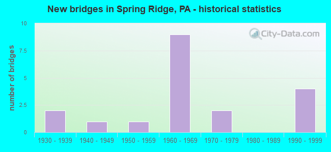
- New bridges - historical statistics
- 21930-1939
- 11940-1949
- 11950-1959
- 91960-1969
- 21970-1979
- 41990-1999

- Reconstructed bridges - Historical Statistics
- 21970-1979
- 01980-1989
- 21990-1999
- 02000-2009
- 12010-2019


- Bridge Condition - Deck
- 10.0%Very good
- 40.0%Good
- 50.0%Satisfactory

- Bridge Condition - Superstructure
- 27.3%Very good
- 36.4%Satisfactory
- 36.4%Fair

- Bridge Condition - Substructure
- 36.4%Good
- 54.5%Satisfactory
- 9.1%Fair

- Bridge Condition - Channel
- 11.1%Satisfactory
- 88.9%Fair

- Bridge Condition - Culverts
- 50.0%Satisfactory
- 50.0%Fair
Find on map >> Show street view
Structure Number: 5144, Location: REBERS BRIDGE ROAD (Lat: 40.373208, Lng: -76.008139), Route carried "on" structure: State highway , Year Built: 1952, Status: Open, Structure Length: 6.28m (20.60ft), Average Daily Traffic: 3,990 (year 2022), Truck Traffic: 3%, Average Future Daily Traffic: 5,691 (year 2032), Design Load: HS 20, Features Intersected: TULPEHOCKEN CREEK, Facility Carried by Structure: SR 3008(LR 06149)
Minimum Vertical Clearance: 30+ m (98+ ft), Kilometerpoint: 11.607, Lanes on structure: 2, Owner: State Highway Agency, Approaching Roadway Width: 7.0m (23.0ft), Material/Design: Steel, Design/Construction: Stringer/Multi-beam, Number Of Spans In Main Unit: 3, Length of Maximum Span: 20.4m (66.9ft), Curb-To-Curb Width: 7.3m (24.0ft), Out-to-Out Width: 7.9m (25.9ft)
Condition: Deck: Satisfactory, Superstructure: Fair, Substructure: Satisfactory, Channel: Fair, Operating Rating: 59.0 metric tons, Method Used To Determine Operating Rating: Load Factor (LF), Inventory Rating: 35.4 metric tons, Method Used To Determine Inventory Rating: Load Factor (LF), Structural Evaluation: Somewhat better than minimum adequacy, Deck Geometry: High priority of replacement, Waterway Adequacy: Better than present minimum criteria, Approach Roadway Alignment: Better than present minimum criteria, Length Of Structure Improvement: 7.20m (23.62ft), Designated Inspection Frequency: Every 24 months, Inspection Date: May 2020, Bridge Improvement Cost: $14,000, Roadway Improvement Cost: $40,000, Total Project Cost: $183,000, Deck Structure Type: Open Grating
Find on map >> Show street view
Structure Number: 5145, Location: PLUM CREEK BRIDGE (Lat: 40.374364, Lng: -76.007819), Route carried "on" structure: State highway , Year Built: 1931, Status: Open, Structure Length: 1.22m (4.00ft), Average Daily Traffic: 3,990 (year 2022), Truck Traffic: 3%, Average Future Daily Traffic: 5,691 (year 2032), Design Load: HS 20, Features Intersected: PLUM CREEK, Facility Carried by Structure: SR 3008(LR 06149)
Minimum Vertical Clearance: 30+ m (98+ ft), Kilometerpoint: 11.607, Lanes on structure: 2, Owner: State Highway Agency, Approaching Roadway Width: 6.1m (20.0ft), Skew: 3 degrees, Material/Design: Concrete, Design/Construction: Tee Beam, Number Of Spans In Main Unit: 1, Length of Maximum Span: 11.3m (37.1ft), Curb-To-Curb Width: 6.2m (20.3ft), Out-to-Out Width: 7.0m (23.0ft)
Condition: Deck: Good, Superstructure: Satisfactory, Substructure: Satisfactory, Channel: Fair, Operating Rating: 45.4 metric tons, Method Used To Determine Operating Rating: Assigned rating based on Load Factor Design (LFD) reported in metric tons, Inventory Rating: 26.3 metric tons, Method Used To Determine Inventory Rating: Assigned rating based on Load Factor Design (LFD) reported in metric tons, Structural Evaluation: Equal to present minimum criteria, Deck Geometry: High priority of replacement, Waterway Adequacy: Better than present minimum criteria, Approach Roadway Alignment: Somewhat better than minimum adequacy, Length Of Structure Improvement: 1.90m (6.23ft), Designated Inspection Frequency: Every 24 months, Inspection Date: September 2020, Bridge Improvement Cost: $36,000, Roadway Improvement Cost: $106,000, Total Project Cost: $485,000, Deck Structure Type: Concrete Cast-file-Place, Wearing Surface/Protective System: Wearing Surface: Bituminous
Find on map >> Show street view
Structure Number: 5187, Location: OVER BROADCASTING RD. (Lat: 40.358603, Lng: -75.977967), Route carried "on" structure: US 222, Year Built: 1997, Status: Open, Structure Length: 2.26m (7.41ft), Average Daily Traffic: 29,857 (year 2022), Truck Traffic: 11%, Average Future Daily Traffic: 41,721 (year 2032), Design Load: HS 25 or greater, Features Intersected: T-702 BROADCASTING RD
Minimum Vertical Clearance: 30+ m (98+ ft), Kilometerpoint: 15.636, Lanes on structure: 2, Lanes under structure: 3, Base Highway Network: Yes, Owner: State Highway Agency, Approaching Roadway Width: 12.2m (40.0ft), Skew: 11 degrees, Material/Design: Prestressed concrete, Design/Construction: Box Beam or Girders - Single/Spread, Number Of Spans In Main Unit: 1, Length of Maximum Span: 21.9m (71.9ft), Curb or Sidewalk Widths: Left: 0.2m (0.7ft), Right: 0.2m (0.7ft), Curb-To-Curb Width: 12.2m (40.0ft), Out-to-Out Width: 13.3m (43.6ft)
Condition: Deck: Good, Superstructure: Very good, Substructure: Good, Operating Rating: 90.7 metric tons, Method Used To Determine Operating Rating: Load Factor (LF), Inventory Rating: 49.0 metric tons, Method Used To Determine Inventory Rating: Load Factor (LF), Structural Evaluation: Better than present minimum criteria, Deck Geometry: Better than present minimum criteria, Underclear: Equal to present minimum criteria, Approach Roadway Alignment: Equal to present desirable criteria, Length Of Structure Improvement: 3.00m (9.84ft), Designated Inspection Frequency: Every 48 months, Inspection Date: Febuary 2019, Deck Structure Type: Concrete Cast-file-Place, Wearing Surface/Protective System: Wearing Surface: Monolithic Concrete, Deck Protection: Epoxy Coated Reinforcing
Find on map >> Show street view
Structure Number: 5188, Location: OVER BROADCASTING RD. (Lat: 40.358792, Lng: -75.977931), Route carried "on" structure: US 222, Year Built: 1997, Status: Open, Structure Length: 2.26m (7.41ft), Average Daily Traffic: 31,275 (year 2022), Truck Traffic: 10%, Average Future Daily Traffic: 41,218 (year 2032), Design Load: HS 25 or greater, Features Intersected: BROADCASTING RD T-702
Minimum Vertical Clearance: 30+ m (98+ ft), Kilometerpoint: 15.646, Lanes on structure: 2, Lanes under structure: 3, Base Highway Network: Yes, Owner: State Highway Agency, Approaching Roadway Width: 12.2m (40.0ft), Skew: 11 degrees, Material/Design: Prestressed concrete, Design/Construction: Box Beam or Girders - Single/Spread, Number Of Spans In Main Unit: 1, Length of Maximum Span: 21.9m (71.9ft), Curb or Sidewalk Widths: Left: 0.2m (0.7ft), Right: 0.2m (0.7ft), Curb-To-Curb Width: 12.2m (40.0ft), Out-to-Out Width: 13.3m (43.6ft)
Condition: Deck: Good, Superstructure: Very good, Substructure: Good, Operating Rating: 90.7 metric tons, Method Used To Determine Operating Rating: Load Factor (LF), Inventory Rating: 49.0 metric tons, Method Used To Determine Inventory Rating: Load Factor (LF), Structural Evaluation: Better than present minimum criteria, Deck Geometry: Better than present minimum criteria, Underclear: Better than present minimum criteria, Approach Roadway Alignment: Equal to present desirable criteria, Length Of Structure Improvement: 3.00m (9.84ft), Designated Inspection Frequency: Every 48 months, Inspection Date: January 2019, Deck Structure Type: Concrete Cast-file-Place, Wearing Surface/Protective System: Wearing Surface: Monolithic Concrete, Deck Protection: Epoxy Coated Reinforcing
Find on map >> Show street view
Structure Number: 5189, Location: PRISON RD.@ COUNTY RD. (Lat: 40.385478, Lng: -76.005264), Route carried "on" structure: State highway , Year Built: 1948, Status: Open, Structure Length: 0.88m (2.89ft), Average Daily Traffic: 189 (year 2020), Truck Traffic: 5%, Average Future Daily Traffic: 301 (year 2032), Design Load: HS 20, Features Intersected: TRIB.TO PLUM CREEK, Facility Carried by Structure: SR 3047(LR 06177)
Minimum Vertical Clearance: 30+ m (98+ ft), Kilometerpoint: 1.106, Lanes on structure: 2, Owner: State Highway Agency, Approaching Roadway Width: 5.2m (17.1ft), Material/Design: Steel, Design/Construction: Stringer/Multi-beam, Number Of Spans In Main Unit: 1, Length of Maximum Span: 8.2m (26.9ft), Curb-To-Curb Width: 6.7m (22.0ft), Out-to-Out Width: 7.2m (23.6ft)
Condition: Deck: Satisfactory, Superstructure: Fair, Substructure: Satisfactory, Channel: Fair, Operating Rating: 66.2 metric tons, Method Used To Determine Operating Rating: Load Factor (LF), Inventory Rating: 39.0 metric tons, Method Used To Determine Inventory Rating: Load Factor (LF), Structural Evaluation: Somewhat better than minimum adequacy, Deck Geometry: Meets minimum limits, Waterway Adequacy: Equal to present minimum criteria, Approach Roadway Alignment: Equal to present desirable criteria, Length Of Structure Improvement: 1.60m (5.25ft), Designated Inspection Frequency: Every 24 months, Inspection Date: November 2020, Bridge Improvement Cost: $3,000, Roadway Improvement Cost: $8,000, Total Project Cost: $37,000, Deck Structure Type: Open Grating
Find on map >> Show street view
Structure Number: 519, Location: 1 MI S OF LEINBACHS (Lat: 40.368233, Lng: -75.990453), Route carried "on" structure: US 222, Year Built: 1962, Year Reconstructed: 1984, Status: Open, Structure Length: 11.67m (38.29ft), Average Daily Traffic: 30,851 (year 2021), Truck Traffic: 10%, Average Future Daily Traffic: 39,679 (year 2032), Design Load: HS 20, Features Intersected: TULPEHOCKEN CREEK;T-602
Minimum Vertical Clearance: 30+ m (98+ ft), Kilometerpoint: 18.226, Lanes on structure: 2, Lanes under structure: 2, Base Highway Network: Yes, Owner: State Highway Agency, Approaching Roadway Width: 9.4m (30.8ft), Skew: 12 degrees, Material/Design: Prestressed concrete, Design/Construction: Box Beam or Girders - Multiple, Number Of Spans In Main Unit: 5, Length of Maximum Span: 24.4m (80.1ft), Curb-To-Curb Width: 10.4m (34.1ft), Out-to-Out Width: 11.4m (37.4ft)
Condition: Deck: Satisfactory, Superstructure: Fair, Substructure: Satisfactory, Channel: Fair, Operating Rating: 89.8 metric tons, Method Used To Determine Operating Rating: Load Factor (LF), Inventory Rating: 43.5 metric tons, Method Used To Determine Inventory Rating: Load Factor (LF), Structural Evaluation: Somewhat better than minimum adequacy, Deck Geometry: Meets minimum limits, Underclear: Superior to present desirable criteria, Waterway Adequacy: Superior to present desirable criteria, Approach Roadway Alignment: Equal to present desirable criteria, Length Of Structure Improvement: 12.60m (41.34ft), Designated Inspection Frequency: Every 24 months, Inspection Date: May 2021, Deck Structure Type: Concrete Cast-file-Place, Wearing Surface/Protective System: Wearing Surface: Epoxy Overlay, Deck Protection: Epoxy Coated Reinforcing
Find on map >> Show street view
Structure Number: 5191, Location: 1 MI S OF LEINBACHS (Lat: 40.368300, Lng: -75.990689), Route carried "on" structure: US 222, Year Built: 1962, Year Reconstructed: 1984, Status: Open, Structure Length: 11.67m (38.29ft), Average Daily Traffic: 29,896 (year 2021), Truck Traffic: 11%, Average Future Daily Traffic: 39,507 (year 2032), Design Load: HS 20, Features Intersected: TULPEHOCKEN CREEK;T-602
Minimum Vertical Clearance: 30+ m (98+ ft), Kilometerpoint: 18.234, Lanes on structure: 2, Lanes under structure: 2, Base Highway Network: Yes, Owner: State Highway Agency, Approaching Roadway Width: 9.4m (30.8ft), Skew: 12 degrees, Material/Design: Prestressed concrete, Design/Construction: Box Beam or Girders - Multiple, Number Of Spans In Main Unit: 5, Length of Maximum Span: 24.4m (80.1ft), Curb-To-Curb Width: 10.4m (34.1ft), Out-to-Out Width: 11.4m (37.4ft)
Condition: Deck: Good, Superstructure: Fair, Substructure: Satisfactory, Channel: Fair, Operating Rating: 89.8 metric tons, Method Used To Determine Operating Rating: Load Factor (LF), Inventory Rating: 43.5 metric tons, Method Used To Determine Inventory Rating: Load Factor (LF), Structural Evaluation: Somewhat better than minimum adequacy, Deck Geometry: Meets minimum limits, Underclear: Superior to present desirable criteria, Waterway Adequacy: Superior to present desirable criteria, Approach Roadway Alignment: Equal to present desirable criteria, Length Of Structure Improvement: 12.60m (41.34ft), Designated Inspection Frequency: Every 24 months, Inspection Date: May 2021, Deck Structure Type: Concrete Cast-file-Place, Wearing Surface/Protective System: Wearing Surface: Epoxy Overlay, Deck Protection: Epoxy Coated Reinforcing
Find on map >> Show street view
Structure Number: 5192, Location: NB OVER BLESSING LANE (Lat: 40.373036, Lng: -75.989069), Route carried "on" structure: US 222, Year Built: 1966, Year Reconstructed: 1996, Status: Open, Structure Length: 1.07m (3.51ft), Average Daily Traffic: 30,851 (year 2021), Truck Traffic: 10%, Average Future Daily Traffic: 39,679 (year 2032), Design Load: HS 20, Features Intersected: TWP RD 552:BLESSING LANE
Minimum Vertical Clearance: 30+ m (98+ ft), Kilometerpoint: 18.826, Lanes on structure: 2, Lanes under structure: 2, Base Highway Network: Yes, Owner: State Highway Agency, Approaching Roadway Width: 11.6m (38.1ft), Skew: 11 degrees, Material/Design: Prestressed concrete, Design/Construction: Box Beam or Girders - Multiple, Number Of Spans In Main Unit: 1, Length of Maximum Span: 9.8m (32.2ft), Curb-To-Curb Width: 11.6m (38.1ft), Out-to-Out Width: 13.3m (43.6ft)
Condition: Deck: Satisfactory, Superstructure: Satisfactory, Substructure: Satisfactory, Operating Rating: 81.6 metric tons, Method Used To Determine Operating Rating: Load Factor (LF), Inventory Rating: 42.6 metric tons, Method Used To Determine Inventory Rating: Load Factor (LF), Structural Evaluation: Equal to present minimum criteria, Deck Geometry: Equal to present minimum criteria, Underclear: High priority of corrective action, Approach Roadway Alignment: Equal to present desirable criteria, Length Of Structure Improvement: 1.80m (5.91ft), Designated Inspection Frequency: Every 24 months, Inspection Date: September 2020, Bridge Improvement Cost: $9,000, Roadway Improvement Cost: $28,000, Total Project Cost: $126,000, Wearing Surface/Protective System: Wearing Surface: Epoxy Overlay
Find on map >> Show street view
Structure Number: 5193, Location: SB OVER BLESSING LANE (Lat: 40.372992, Lng: -75.989336), Route carried "on" structure: US 222, Year Built: 1966, Year Reconstructed: 1996, Status: Open, Structure Length: 1.07m (3.51ft), Average Daily Traffic: 29,896 (year 2021), Truck Traffic: 11%, Average Future Daily Traffic: 39,507 (year 2032), Design Load: HS 20, Features Intersected: TWP RD 552:BLESSING LANE
Minimum Vertical Clearance: 30+ m (98+ ft), Kilometerpoint: 18.818, Lanes on structure: 2, Lanes under structure: 2, Base Highway Network: Yes, Owner: State Highway Agency, Approaching Roadway Width: 11.6m (38.1ft), Skew: 11 degrees, Material/Design: Prestressed concrete, Design/Construction: Box Beam or Girders - Multiple, Number Of Spans In Main Unit: 1, Length of Maximum Span: 9.4m (30.8ft), Curb-To-Curb Width: 11.6m (38.1ft), Out-to-Out Width: 13.3m (43.6ft)
Condition: Deck: Satisfactory, Superstructure: Satisfactory, Substructure: Good, Operating Rating: 81.6 metric tons, Method Used To Determine Operating Rating: Load Factor (LF), Inventory Rating: 42.6 metric tons, Method Used To Determine Inventory Rating: Load Factor (LF), Structural Evaluation: Equal to present minimum criteria, Deck Geometry: Equal to present minimum criteria, Underclear: High priority of corrective action, Approach Roadway Alignment: Equal to present desirable criteria, Length Of Structure Improvement: 1.80m (5.91ft), Designated Inspection Frequency: Every 24 months, Inspection Date: September 2020, Bridge Improvement Cost: $9,000, Roadway Improvement Cost: $28,000, Total Project Cost: $126,000, Wearing Surface/Protective System: Wearing Surface: Epoxy Overlay
Find on map >> Show street view
Structure Number: 5324, Location: 1 MI.NO.OF STATE HILL (Lat: 40.380611, Lng: -76.022822), Route carried "on" structure: County highway 102, Year Built: 1936, Status: Open, Structure Length: 1.37m (4.49ft), Average Daily Traffic: 979 (year 2020), Truck Traffic: 3%, Average Future Daily Traffic: 1,006 (year 2025), Features Intersected: PLUM CREEK, Facility Carried by Structure: CO.WELFARE ROAD
Minimum Vertical Clearance: 30+ m (98+ ft), Kilometerpoint: 0.000, Lanes on structure: 2, Owner: County Highway Agency, Approaching Roadway Width: 6.7m (22.0ft), Material/Design: Concrete, Design/Construction: Arch - Deck, Number Of Spans In Main Unit: 1, Length of Maximum Span: 13.4m (44.0ft), Curb-To-Curb Width: 6.9m (22.6ft), Out-to-Out Width: 8.2m (26.9ft)
Condition: Superstructure: Satisfactory, Substructure: Fair, Channel: Satisfactory, Operating Rating: 89.8 metric tons, Method Used To Determine Operating Rating: Load Factor (LF), Inventory Rating: 89.8 metric tons, Method Used To Determine Inventory Rating: Load Factor (LF), Structural Evaluation: Somewhat better than minimum adequacy, Deck Geometry: Meets minimum limits, Waterway Adequacy: Superior to present desirable criteria, Approach Roadway Alignment: Equal to present desirable criteria, Length Of Structure Improvement: 2.10m (6.89ft), Designated Inspection Frequency: Every 24 months, Inspection Date: October 2021
Find on map >> Show street view
Structure Number: 5389, Location: NEAR VAN REED ROAD (Lat: 40.359792, Lng: -75.995694), Route carried "on" structure: City street , Year Built: 1972, Status: Open, Structure Length: 1.07m (3.51ft), Average Daily Traffic: 488 (year 1985), Truck Traffic: 1%, Average Future Daily Traffic: 2,000 (year 2030), Features Intersected: CACOOSING CREEK, Facility Carried by Structure: SWEITZER RD
Minimum Vertical Clearance: 30+ m (98+ ft), Kilometerpoint: 0.000, Lanes on structure: 2, Owner: Town or Township Highway Agency, Approaching Roadway Width: 4.9m (16.1ft), Material/Design: Concrete, Design/Construction: Culvert, Number Of Spans In Main Unit: 2, Length of Maximum Span: 4.9m (16.1ft), Curb or Sidewalk Widths: Left: 0.2m (0.7ft), Right: 0.2m (0.7ft), Curb-To-Curb Width: 6.1m (20.0ft), Out-to-Out Width: 7.3m (24.0ft)
Condition: Channel: Fair, Culverts: Satisfactory, Operating Rating: 54.4 metric tons, Method Used To Determine Operating Rating: Field evaluation and documented engineering judgment, Inventory Rating: 32.7 metric tons, Method Used To Determine Inventory Rating: Field evaluation and documented engineering judgment, Structural Evaluation: Equal to present minimum criteria, Deck Geometry: High priority of corrective action, Waterway Adequacy: Better than present minimum criteria, Approach Roadway Alignment: Equal to present desirable criteria, Length Of Structure Improvement: 1.80m (5.91ft), Designated Inspection Frequency: Every 24 months, Inspection Date: May 2020, Wearing Surface/Protective System: Wearing Surface: Monolithic Concrete
Find on map >> Show street view
Structure Number: 539, Location: JUST WEST OF SR 222 (Lat: 40.366083, Lng: -75.994528), Route carried "on" structure: City street , Year Built: 1968, Year Reconstructed: 2019, Status: Open, Structure Length: 1.68m (5.51ft), Average Daily Traffic: 1,268 (year 1985), Truck Traffic: 1%, Average Future Daily Traffic: 2,600 (year 2030), Design Load: HL 93, Features Intersected: CACOOSING CREEK, Facility Carried by Structure: PAPER MILL RD
Minimum Vertical Clearance: 30+ m (98+ ft), Kilometerpoint: 0.000, Lanes on structure: 2, Owner: Town or Township Highway Agency, Approaching Roadway Width: 6.7m (22.0ft), Material/Design: Steel, Design/Construction: Stringer/Multi-beam, Number Of Spans In Main Unit: 1, Length of Maximum Span: 15.8m (51.8ft), Curb or Sidewalk Widths: Left: 2.4m (7.9ft), Right: 0.0m, Curb-To-Curb Width: 12.4m (40.7ft), Out-to-Out Width: 13.1m (43.0ft)
Condition: Deck: Very good, Superstructure: Very good, Substructure: Good, Channel: Fair, Operating Rating: 43.7 metric tons, Method Used To Determine Operating Rating: Assigned ratings based on Load and Resistance Factor Design (LRFD) reported by rating factor (RF) using HL93 loadings, Inventory Rating: 33.7 metric tons, Method Used To Determine Inventory Rating: Assigned ratings based on Load and Resistance Factor Design (LRFD) reported by rating factor (RF) using HL93 loadings, Structural Evaluation: Better than present minimum criteria, Deck Geometry: Better than present minimum criteria, Waterway Adequacy: Better than present minimum criteria, Approach Roadway Alignment: Somewhat better than minimum adequacy, Length Of Structure Improvement: 1.70m (5.58ft), Designated Inspection Frequency: Every 24 months, Inspection Date: November 2021, Bridge Improvement Cost: $12,000, Roadway Improvement Cost: $35,000, Total Project Cost: $161,000, Deck Structure Type: Open Grating
Find on map >> Show street view
Structure Number: 47972, Location: BLUE MARSH (Lat: 40.399425, Lng: -76.031172), Route carried "on" structure: City street , Year Built: 1979, Status: Open, Structure Length: 0.91m (2.99ft), Average Daily Traffic: 500 (year 2013), Truck Traffic: 1%, Average Future Daily Traffic: 550 (year 2023), Design Load: HS 20, Features Intersected: PLUM CREEK, Facility Carried by Structure: PALISADES DRIVE
Minimum Vertical Clearance: 30+ m (98+ ft), Kilometerpoint: 0.000, Lanes on structure: 2, Owner: Town or Township Highway Agency, Approaching Roadway Width: 6.7m (22.0ft), Skew: 4 degrees, Material/Design: Concrete, Design/Construction: Culvert, Number Of Spans In Main Unit: 1, Length of Maximum Span: 9.1m (29.9ft), Curb or Sidewalk Widths: Left: 0.2m (0.7ft), Right: 0.2m (0.7ft)
Condition: Channel: Fair, Culverts: Fair, Operating Rating: 49.0 metric tons, Method Used To Determine Operating Rating: Field evaluation and documented engineering judgment, Inventory Rating: 32.7 metric tons, Method Used To Determine Inventory Rating: Field evaluation and documented engineering judgment, Structural Evaluation: Somewhat better than minimum adequacy, Waterway Adequacy: Superior to present desirable criteria, Approach Roadway Alignment: Equal to present desirable criteria, Designated Inspection Frequency: Every 24 months, Inspection Date: September 2021
Find on map >> Show street view
Structure Number: 5187, Location: OVER BROADCASTING RD. (Lat: 40.358603, Lng: -75.977967), Route carried "under" structure: City street , Year Built: 1997, Structure Length: 0. m, Average Daily Traffic: 100 (year 2005), Truck Traffic: 1%, Features Intersected: T-702 BROADCASTING RD, Facility Carried by Structure: US 222 SB
Minimum Vertical Clearance: 4.48m (14.70ft), Kilometerpoint: 0.000, Lanes on structure: 2, Lanes under structure: 3, Material/Design: Prestressed concrete, Design/Construction: Box Beam or Girders - Single/Spread, Length of Maximum Span: 21.9m (71.9ft)
Find on map >> Show street view
Structure Number: 5188, Location: OVER BROADCASTING RD. (Lat: 40.358792, Lng: -75.977931), Route carried "under" structure: City street , Year Built: 1997, Structure Length: 0. m, Average Daily Traffic: 100 (year 2005), Truck Traffic: 1%, Features Intersected: BROADCASTING RD T-702, Facility Carried by Structure: US 222 NB
Minimum Vertical Clearance: 5.00m (16.40ft), Kilometerpoint: 0.000, Lanes on structure: 2, Lanes under structure: 3, Material/Design: Prestressed concrete, Design/Construction: Box Beam or Girders - Single/Spread, Length of Maximum Span: 21.9m (71.9ft)
Find on map >> Show street view
Structure Number: 519, Location: 1 MI S OF LEINBACHS (Lat: 40.368233, Lng: -75.990453), Route carried "under" structure: City street , Year Built: 1962, Structure Length: 0. m, Average Daily Traffic: 455 (year 1994), Truck Traffic: 1%, Features Intersected: TULPEHOCKEN CREEK;T-602, Facility Carried by Structure: SR 0222NB (LR1035)
Minimum Vertical Clearance: 7.38m (24.21ft), Kilometerpoint: 0.000, Lanes on structure: 2, Lanes under structure: 2, Material/Design: Prestressed concrete, Design/Construction: Box Beam or Girders - Multiple, Length of Maximum Span: 24.4m (80.1ft)
Find on map >> Show street view
Structure Number: 5191, Location: 1 MI S OF LEINBACHS (Lat: 40.368300, Lng: -75.990689), Route carried "under" structure: City street , Year Built: 1962, Structure Length: 0. m, Average Daily Traffic: 455 (year 1994), Truck Traffic: 1%, Features Intersected: TULPEHOCKEN CREEK;T-602, Facility Carried by Structure: SR0222SB(LR 1035)
Minimum Vertical Clearance: 7.11m (23.33ft), Kilometerpoint: 0.000, Lanes on structure: 2, Lanes under structure: 2, Material/Design: Prestressed concrete, Design/Construction: Box Beam or Girders - Multiple, Length of Maximum Span: 24.4m (80.1ft)
Find on map >> Show street view
Structure Number: 5192, Location: NB OVER BLESSING LANE (Lat: 40.373036, Lng: -75.989069), Route carried "under" structure: City street , Year Built: 1966, Structure Length: 0. m, Average Daily Traffic: 577 (year 1994), Truck Traffic: 1%, Features Intersected: TWP RD 552:BLESSING LANE, Facility Carried by Structure: SR 0222-SH(LR1035)
Minimum Vertical Clearance: 5.06m (16.60ft), Kilometerpoint: 0.000, Lanes on structure: 2, Lanes under structure: 2, Material/Design: Prestressed concrete, Design/Construction: Box Beam or Girders - Multiple, Length of Maximum Span: 9.8m (32.2ft)
Find on map >> Show street view
Structure Number: 5193, Location: SB OVER BLESSING LANE (Lat: 40.372992, Lng: -75.989336), Route carried "under" structure: City street , Year Built: 1966, Structure Length: 0. m, Average Daily Traffic: 577 (year 1994), Truck Traffic: 1%, Features Intersected: TWP RD 552:BLESSING LANE, Facility Carried by Structure: SR 0222-SB(LR1035)
Minimum Vertical Clearance: 4.57m (14.99ft), Kilometerpoint: 0.000, Lanes on structure: 2, Lanes under structure: 2, Material/Design: Prestressed concrete, Design/Construction: Box Beam or Girders - Multiple, Length of Maximum Span: 9.4m (30.8ft)