Bridge Statistics for Spring Mount, Pennsylvania (PA)
Condition, Traffic, Stress, Structural Evaluation, Project Costs
- National Bridge Inventory (NBI) Statistics
- 12Number of bridges
- 92ft / 28.3mTotal length
- $3,576,000Total costs
- 33,556Total average daily traffic
- 4,599Total average daily truck traffic
- 43,354Total future (year 1997) average daily traffic
- National Bridge Inventory (NBI) Registered Bridges for Spring Mount
- No street view available for this location
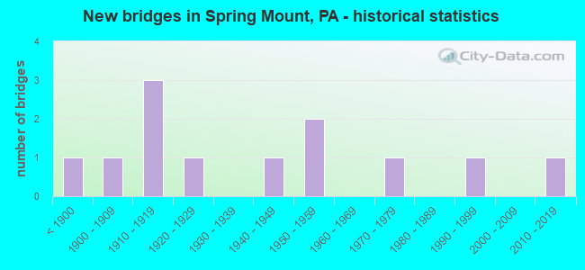
- New bridges - historical statistics
- 1Before 1900
- 11900-1909
- 31910-1919
- 11920-1929
- 11940-1949
- 21950-1959
- 11970-1979
- 11990-1999
- 12010-2019


- Bridge Condition - Deck
- 16.7%Very good
- 50.0%Good
- 16.7%Fair
- 16.7%Poor

- Bridge Condition - Superstructure
- 20.0%Very good
- 10.0%Good
- 40.0%Satisfactory
- 10.0%Fair
- 10.0%Poor
- 10.0%Failed

- Bridge Condition - Substructure
- 10.0%Very good
- 30.0%Good
- 20.0%Satisfactory
- 30.0%Fair
- 10.0%Critical

- Bridge Condition - Channel
- 8.3%Good
- 8.3%Satisfactory
- 50.0%Fair
- 33.3%Poor

- Bridge Condition - Culverts
- 50.0%Good
- 50.0%Satisfactory
Find on map >> Show street view
Structure Number: 27162, Location: 1MI.S.ZIEGLERSVIL. 3029E7 (Lat: 40.272356, Lng: -75.472872), Route carried "on" structure: State highway 29, Year Built: 1947, Status: Open, Structure Length: 5.85m (19.19ft), Average Daily Traffic: 11,587 (year 2020), Truck Traffic: 20%, Average Future Daily Traffic: 16,287 (year 2032), Design Load: HS 20, Features Intersected: SWAMP CREEK, Facility Carried by Structure: GRAVEL PIKE
Minimum Vertical Clearance: 30+ m (98+ ft), Kilometerpoint: 18.277, Lanes on structure: 2, Base Highway Network: Yes, Owner: State Highway Agency, Approaching Roadway Width: 12.2m (40.0ft), Skew: 5 degrees, Material/Design: Steel, Design/Construction: Stringer/Multi-beam, Number Of Spans In Main Unit: 3, Length of Maximum Span: 18.9m (62.0ft), Curb or Sidewalk Widths: Left: 0.2m (0.7ft), Right: 1.5m (4.9ft), Curb-To-Curb Width: 9.1m (29.9ft), Out-to-Out Width: 11.6m (38.1ft)
Condition: Deck: Good, Superstructure: Fair, Substructure: Fair, Channel: Poor, Operating Rating: 64.4 metric tons, Method Used To Determine Operating Rating: Load Factor (LF), Inventory Rating: 39.0 metric tons, Method Used To Determine Inventory Rating: Load Factor (LF), Structural Evaluation: Somewhat better than minimum adequacy, Deck Geometry: High priority of corrective action, Waterway Adequacy: Superior to present desirable criteria, Approach Roadway Alignment: Better than present minimum criteria, Length Of Structure Improvement: 6.50m (21.33ft), Designated Inspection Frequency: Every 24 months, Inspection Date: July 2021, Bridge Improvement Cost: $204,000, Roadway Improvement Cost: $600,000, Total Project Cost: $2,752,000, Deck Structure Type: Concrete Cast-file-Place, Wearing Surface/Protective System: Wearing Surface: Monolithic Concrete
Find on map >> Show street view
Structure Number: 27163, Location: N OF ZIEGLERV 3029C5 (Lat: 40.286636, Lng: -75.481361), Route carried "on" structure: State highway 29, Year Built: 1954, Status: Open, Structure Length: 1.10m (3.61ft), Average Daily Traffic: 6,283 (year 2022), Truck Traffic: 18%, Average Future Daily Traffic: 7,361 (year 2032), Design Load: H 20, Features Intersected: GOSHENHOPPEN CREEK, Facility Carried by Structure: GRAVEL PIKE
Minimum Vertical Clearance: 30+ m (98+ ft), Kilometerpoint: 19.537, Lanes on structure: 2, Base Highway Network: Yes, Owner: State Highway Agency, Approaching Roadway Width: 11.0m (36.1ft), Skew: 4 degrees, Material/Design: Concrete, Design/Construction: Tee Beam, Number Of Spans In Main Unit: 1, Length of Maximum Span: 10.1m (33.1ft), Curb or Sidewalk Widths: Left: 0.2m (0.7ft), Right: 0.2m (0.7ft), Curb-To-Curb Width: 11.0m (36.1ft), Out-to-Out Width: 11.9m (39.0ft)
Condition: Deck: Fair, Superstructure: Satisfactory, Substructure: Fair, Channel: Poor, Operating Rating: 59.9 metric tons, Method Used To Determine Operating Rating: Load Factor (LF), Inventory Rating: 36.3 metric tons, Method Used To Determine Inventory Rating: Load Factor (LF), Structural Evaluation: Somewhat better than minimum adequacy, Deck Geometry: Meets minimum limits, Waterway Adequacy: Equal to present minimum criteria, Approach Roadway Alignment: Equal to present desirable criteria, Length Of Structure Improvement: 1.70m (5.58ft), Designated Inspection Frequency: Every 24 months, Inspection Date: July 2021, Deck Structure Type: Concrete Cast-file-Place, Wearing Surface/Protective System: Wearing Surface: Bituminous
Find on map >> Show street view
Structure Number: 27194, Location: WEST OF PENNA-29 13J05 (Lat: 40.278094, Lng: -75.488214), Route carried "on" structure: State highway 73, Year Built: 1956, Status: Open, Structure Length: 0.82m (2.69ft), Average Daily Traffic: 6,860 (year 2020), Truck Traffic: 10%, Average Future Daily Traffic: 10,115 (year 2032), Design Load: HS 20, Features Intersected: SCIOTO CREEK, Facility Carried by Structure: BIG ROAD/3029B6
Minimum Vertical Clearance: 30+ m (98+ ft), Kilometerpoint: 13.995, Lanes on structure: 2, Base Highway Network: Yes, Owner: State Highway Agency, Approaching Roadway Width: 7.3m (24.0ft), Skew: 1 degrees, Material/Design: Concrete, Design/Construction: Culvert, Number Of Spans In Main Unit: 1, Length of Maximum Span: 8.2m (26.9ft)
Condition: Channel: Poor, Culverts: Satisfactory, Operating Rating: 65.3 metric tons, Method Used To Determine Operating Rating: Field evaluation and documented engineering judgment, Inventory Rating: 32.7 metric tons, Method Used To Determine Inventory Rating: Field evaluation and documented engineering judgment, Structural Evaluation: Equal to present minimum criteria, Waterway Adequacy: Superior to present desirable criteria, Approach Roadway Alignment: Equal to present desirable criteria, Length Of Structure Improvement: 1.60m (5.25ft), Designated Inspection Frequency: Every 24 months, Inspection Date: June 2021
Find on map >> Show street view
Structure Number: 27557, Location: E. OF PA 29 13K4/3029D5 (Lat: 40.284042, Lng: -75.479508), Route carried "on" structure: State highway , Year Built: 1992, Status: Open, Structure Length: 1.13m (3.71ft), Average Daily Traffic: 1,104 (year 2022), Truck Traffic: 6%, Average Future Daily Traffic: 1,187 (year 2032), Design Load: HS 25 or greater, Features Intersected: GOSHENHOPPEN CREEK, Facility Carried by Structure: SALFORD STATION RD
Minimum Vertical Clearance: 30+ m (98+ ft), Kilometerpoint: 0.000, Lanes on structure: 2, Owner: State Highway Agency, Approaching Roadway Width: 10.1m (33.1ft), Material/Design: Prestressed concrete, Design/Construction: Box Beam or Girders - Multiple, Number Of Spans In Main Unit: 1, Length of Maximum Span: 10.7m (35.1ft), Curb or Sidewalk Widths: Left: 0.2m (0.7ft), Right: 0.2m (0.7ft), Curb-To-Curb Width: 10.0m (32.8ft), Out-to-Out Width: 11.1m (36.4ft)
Condition: Deck: Good, Superstructure: Very good, Substructure: Good, Channel: Fair, Inventory Rating: 55.3 metric tons, Method Used To Determine Inventory Rating: Load Factor (LF), Structural Evaluation: Better than present minimum criteria, Deck Geometry: Somewhat better than minimum adequacy, Waterway Adequacy: Better than present minimum criteria, Approach Roadway Alignment: Equal to present desirable criteria, Length Of Structure Improvement: 1.70m (5.58ft), Designated Inspection Frequency: Every 24 months, Inspection Date: December 2020, Deck Structure Type: Concrete Cast-file-Place, Wearing Surface/Protective System: Wearing Surface: Monolithic Concrete, Deck Protection: Epoxy Coated Reinforcing
Find on map >> Show street view
Structure Number: 27816, Location: 1000' (S)OF SR0073 3029C7 (Lat: 40.274628, Lng: -75.485142), Route carried "on" structure: County highway , Year Built: 1888, Year Reconstructed: 1998, Status: Posted for load, Structure Length: 4.21m (13.81ft), Average Daily Traffic: 750 (year 2015), Truck Traffic: 1%, Average Future Daily Traffic: 1,000 (year 2035), Design Load: HS 20+Mod, Features Intersected: SWAMP CREEK, Facility Carried by Structure: GERLOFF ROAD
Minimum Vertical Clearance: 5.31m (17.42ft), Kilometerpoint: 0.000, Lanes on structure: 1, Owner: Town or Township Highway Agency, Approaching Roadway Width: 6.7m (22.0ft), Material/Design: Steel, Design/Construction: Arch - Thru, Number Of Spans In Main Unit: 1, Length of Maximum Span: 40.8m (133.9ft), Curb-To-Curb Width: 4.6m (15.1ft), Out-to-Out Width: 5.3m (17.4ft)
Condition: Deck: Good, Superstructure: Good, Substructure: Good, Channel: Fair, Operating Rating: 61.7 metric tons, Method Used To Determine Operating Rating: Load Factor (LF), Inventory Rating: 37.2 metric tons, Method Used To Determine Inventory Rating: Load Factor (LF), Structural Evaluation: Better than present minimum criteria, Deck Geometry: High priority of replacement, Waterway Adequacy: Better than present minimum criteria, Approach Roadway Alignment: Equal to present desirable criteria, Length Of Structure Improvement: 5.20m (17.06ft), Designated Inspection Frequency: Every 24 months, Critical Feature Inspection Frequency: Every 12 months, Other Special Inspection Frequency: Every 12 months, Inspection Date: Febuary 2021, Critical Feature Inspection Date: Febuary 2021, Other Special Inspection Date: Febuary 2021, Deck Structure Type: Open Grating
Find on map >> Show street view
Structure Number: 2792, Location: ADC 3028-K3 (Lat: 40.293975, Lng: -75.505253), Route carried "on" structure: City street , Year Built: 1909, Status: Open, Structure Length: 1.37m (4.49ft), Average Daily Traffic: 784 (year 2019), Average Future Daily Traffic: 722 (year 2018), Features Intersected: SCIOTO CREEK, Facility Carried by Structure: FAUST ROAD
Minimum Vertical Clearance: 30+ m (98+ ft), Kilometerpoint: 0.000, Lanes on structure: 2, Owner: County Highway Agency, Approaching Roadway Width: 5.5m (18.0ft), Material/Design: Masonry, Design/Construction: Arch - Deck, Number Of Spans In Main Unit: 2, Length of Maximum Span: 6.1m (20.0ft), Curb-To-Curb Width: 6.2m (20.3ft), Out-to-Out Width: 7.2m (23.6ft)
Condition: Superstructure: Satisfactory, Substructure: Fair, Channel: Fair, Operating Rating: 62.6 metric tons, Method Used To Determine Operating Rating: Field evaluation and documented engineering judgment, Inventory Rating: 37.2 metric tons, Method Used To Determine Inventory Rating: Field evaluation and documented engineering judgment, Structural Evaluation: Somewhat better than minimum adequacy, Deck Geometry: High priority of corrective action, Waterway Adequacy: Equal to present minimum criteria, Approach Roadway Alignment: Equal to present desirable criteria, Length Of Structure Improvement: 1.90m (6.23ft), Designated Inspection Frequency: Every 24 months, Inspection Date: April 2020, Bridge Improvement Cost: $7,000, Roadway Improvement Cost: $20,000, Total Project Cost: $91,000
Find on map >> Show street view
Structure Number: 27922, Location: .9 Mi SW PA-29 3029-C4 (Lat: 40.286931, Lng: -75.495192), Route carried "on" structure: City street 73, Year Built: 1915, Status: Open, Structure Length: 1.16m (3.81ft), Average Daily Traffic: 97 (year 2019), Average Future Daily Traffic: 156 (year 2018), Features Intersected: SCIOTO CREEK, Facility Carried by Structure: SIMMONS ROAD
Minimum Vertical Clearance: 30+ m (98+ ft), Kilometerpoint: 0.000, Lanes on structure: 2, Owner: County Highway Agency, Approaching Roadway Width: 5.8m (19.0ft), Material/Design: Masonry, Design/Construction: Arch - Deck, Number Of Spans In Main Unit: 2, Length of Maximum Span: 5.2m (17.1ft), Curb-To-Curb Width: 5.8m (19.0ft), Out-to-Out Width: 7.2m (23.6ft)
Condition: Superstructure: Satisfactory, Substructure: Satisfactory, Channel: Good, Operating Rating: 70.8 metric tons, Method Used To Determine Operating Rating: Field evaluation and documented engineering judgment, Inventory Rating: 41.7 metric tons, Method Used To Determine Inventory Rating: Field evaluation and documented engineering judgment, Structural Evaluation: Equal to present minimum criteria, Deck Geometry: Meets minimum limits, Waterway Adequacy: Better than present minimum criteria, Approach Roadway Alignment: Equal to present desirable criteria, Length Of Structure Improvement: 1.70m (5.58ft), Designated Inspection Frequency: Every 24 months, Inspection Date: April 2020, Bridge Improvement Cost: $34,000, Roadway Improvement Cost: $99,000, Total Project Cost: $454,000
Find on map >> Show street view
Structure Number: 27976, Location: 3029-E7 ADC Street Atlas (Lat: 40.272611, Lng: -75.474133), Route carried "on" structure: City street 73, Year Built: 1915, Status: Closed, Structure Length: 3.08m (10.10ft), Average Daily Traffic: 100 (year 1977), Average Future Daily Traffic: 140 (year 1997), Features Intersected: SWAMP CREEK, Facility Carried by Structure: OLD GRAVEL PIKE
Minimum Vertical Clearance: 30+ m (98+ ft), Kilometerpoint: 0.000, Lanes on structure: 2, Owner: County Highway Agency, Approaching Roadway Width: 6.1m (20.0ft), Material/Design: Masonry, Design/Construction: Arch - Deck, Number Of Spans In Main Unit: 3, Length of Maximum Span: 10.7m (35.1ft), Curb-To-Curb Width: 6.0m (19.7ft), Out-to-Out Width: 6.0m (19.7ft)
Condition: Superstructure: Failed, Substructure: Critical, Channel: Fair, Deck Geometry: Meets minimum limits, Waterway Adequacy: Equal to present desirable criteria, Approach Roadway Alignment: Equal to present desirable criteria, Bridge Posting: Required (Relationship of Operating Rating to Maximum Legal Load: > 39.9% below), Length Of Structure Improvement: 3.80m (12.47ft), Designated Inspection Frequency: Every 24 months, Inspection Date: April 2020, Bridge Improvement Cost: $13,000, Roadway Improvement Cost: $38,000, Total Project Cost: $174,000
Find on map >> Show street view
Structure Number: 28067, Location: .25 Mi SW PA-29 3029-C4 (Lat: 40.292025, Lng: -75.484831), Route carried "on" structure: City street , Year Built: 1927, Status: Posted for load, Structure Length: 0.73m (2.40ft), Average Daily Traffic: 300 (year 2018), Truck Traffic: 2%, Average Future Daily Traffic: 350 (year 2038), Features Intersected: GOSHENHOPPEN CREEK, Facility Carried by Structure: SIMMONS ROAD
Minimum Vertical Clearance: 30+ m (98+ ft), Kilometerpoint: 0.000, Lanes on structure: 2, Owner: Town or Township Highway Agency, Approaching Roadway Width: 4.9m (16.1ft), Material/Design: Concrete, Design/Construction: Slab, Number Of Spans In Main Unit: 1, Length of Maximum Span: 6.7m (22.0ft), Curb or Sidewalk Widths: Left: 0.2m (0.7ft), Right: 0.2m (0.7ft), Curb-To-Curb Width: 5.9m (19.4ft), Out-to-Out Width: 6.6m (21.7ft)
Condition: Deck: Poor, Superstructure: Poor, Substructure: Satisfactory, Channel: Satisfactory, Operating Rating: 58.1 metric tons, Method Used To Determine Operating Rating: Field evaluation and documented engineering judgment, Inventory Rating: 34.5 metric tons, Method Used To Determine Inventory Rating: Field evaluation and documented engineering judgment, Structural Evaluation: Meets minimum limits, Deck Geometry: High priority of corrective action, Waterway Adequacy: Equal to present desirable criteria, Approach Roadway Alignment: Equal to present desirable criteria, Length Of Structure Improvement: 0.90m (2.95ft), Designated Inspection Frequency: Every 24 months, Other Special Inspection Frequency: Every 12 months, Inspection Date: July 2020, Other Special Inspection Date: July 2020, Bridge Improvement Cost: $6,000, Roadway Improvement Cost: $16,000, Total Project Cost: $75,000, Wearing Surface/Protective System: Wearing Surface: Bituminous
Find on map >> Show street view
Structure Number: 42287, Location: 400' NE SR 29/73 3029-D6 (Lat: 40.276675, Lng: -75.476764), Route carried "on" structure: City street 7206, Year Built: 1915, Status: Open, Structure Length: 1.07m (3.51ft), Average Daily Traffic: 1,000 (year 2018), Truck Traffic: 2%, Average Future Daily Traffic: 1,200 (year 2038), Features Intersected: GOSHENHOPPEN CREEK, Facility Carried by Structure: ZIEGLERVILLE ROAD
Minimum Vertical Clearance: 30+ m (98+ ft), Kilometerpoint: 0.000, Lanes on structure: 2, Owner: Town or Township Highway Agency, Approaching Roadway Width: 6.4m (21.0ft), Material/Design: Masonry, Design/Construction: Arch - Deck, Number Of Spans In Main Unit: 2, Length of Maximum Span: 4.6m (15.1ft), Curb-To-Curb Width: 6.0m (19.7ft), Out-to-Out Width: 7.2m (23.6ft)
Condition: Superstructure: Satisfactory, Substructure: Good, Channel: Poor, Operating Rating: 54.4 metric tons, Method Used To Determine Operating Rating: Field evaluation and documented engineering judgment, Inventory Rating: 32.7 metric tons, Method Used To Determine Inventory Rating: Field evaluation and documented engineering judgment, Structural Evaluation: Equal to present minimum criteria, Deck Geometry: High priority of replacement, Waterway Adequacy: Equal to present desirable criteria, Approach Roadway Alignment: Equal to present desirable criteria, Length Of Structure Improvement: 1.50m (4.92ft), Designated Inspection Frequency: Every 24 months, Inspection Date: April 2020, Bridge Improvement Cost: $2,000, Roadway Improvement Cost: $7,000, Total Project Cost: $30,000
Find on map >> Show street view
Structure Number: 46023, Location: SPRING MOUNT 14D5/3029H7 (Lat: 40.274772, Lng: -75.455486), Route carried "on" structure: State highway , Year Built: 2010, Status: Open, Structure Length: 6.95m (22.80ft), Average Daily Traffic: 4,592 (year 2021), Truck Traffic: 8%, Average Future Daily Traffic: 4,737 (year 2032), Design Load: HL 93, Features Intersected: PERKIOMEN CREEK, Facility Carried by Structure: SPRING MOUNT ROAD
Minimum Vertical Clearance: 30+ m (98+ ft), Kilometerpoint: 1.408, Lanes on structure: 2, Owner: State Highway Agency, Approaching Roadway Width: 6.7m (22.0ft), Material/Design: Prestressed concrete continuous, Design/Construction: Stringer/Multi-beam, Number Of Spans In Main Unit: 3, Length of Maximum Span: 22.6m (74.1ft), Curb or Sidewalk Widths: Left: 0.2m (0.7ft), Right: 3.7m (12.1ft), Curb-To-Curb Width: 8.5m (27.9ft), Out-to-Out Width: 13.6m (44.6ft)
Condition: Deck: Very good, Superstructure: Very good, Substructure: Very good, Channel: Fair, Operating Rating: 75.3 metric tons, Method Used To Determine Operating Rating: Load Factor (LF), Inventory Rating: 39.0 metric tons, Method Used To Determine Inventory Rating: Load Factor (LF), Structural Evaluation: Equal to present desirable criteria, Deck Geometry: Meets minimum limits, Waterway Adequacy: Better than present minimum criteria, Approach Roadway Alignment: Equal to present desirable criteria, Designated Inspection Frequency: Every 24 months, Inspection Date: September 2020, Deck Structure Type: Concrete Cast-file-Place, Wearing Surface/Protective System: Wearing Surface: Monolithic Concrete, Membrane: Other, Deck Protection: Epoxy Coated Reinforcing
Find on map >> Show street view
Structure Number: 57096, Location: 350 FT E MEMORIAL DR (Lat: 40.273972, Lng: -75.471389), Route carried "on" structure: City street , Year Built: 1972, Status: Open, Structure Length: 0.85m (2.79ft), Average Daily Traffic: 99 (year 2020), Truck Traffic: 1%, Average Future Daily Traffic: 99 (year 2040), Design Load: HS 20, Features Intersected: GOSHENHOPPEN CREEK, Facility Carried by Structure: SILVERBROOK DRIVE
Minimum Vertical Clearance: 30+ m (98+ ft), Kilometerpoint: 0.000, Lanes on structure: 2, Owner: Town or Township Highway Agency, Approaching Roadway Width: 6.7m (22.0ft), Skew: 2 degrees, Material/Design: Concrete, Design/Construction: Culvert, Number Of Spans In Main Unit: 2, Length of Maximum Span: 4.0m (13.1ft), Curb-To-Curb Width: 8.9m (29.2ft), Out-to-Out Width: 9.3m (30.5ft)
Condition: Channel: Fair, Culverts: Good, Operating Rating: 65.3 metric tons, Method Used To Determine Operating Rating: Field evaluation and documented engineering judgment, Inventory Rating: 39.0 metric tons, Method Used To Determine Inventory Rating: Field evaluation and documented engineering judgment, Structural Evaluation: Better than present minimum criteria, Deck Geometry: Better than present minimum criteria, Waterway Adequacy: Better than present minimum criteria, Approach Roadway Alignment: Equal to present desirable criteria, Designated Inspection Frequency: Every 24 months, Inspection Date: January 2020