Bridge Statistics for Splendora, Texas (TX)
Condition, Traffic, Stress, Structural Evaluation, Project Costs
- National Bridge Inventory (NBI) Statistics
- 11Number of bridges
- 141ft / 42.6mTotal length
- $121,000Total costs
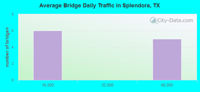
- 235,933Total average daily traffic
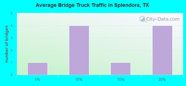
- 35,532Total average daily truck traffic
- National Bridge Inventory (NBI) Registered Bridges for Splendora
- No street view available for this location
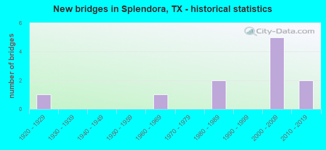
- New bridges - historical statistics
- 11920-1929
- 11960-1969
- 21980-1989
- 52000-2009
- 22010-2019
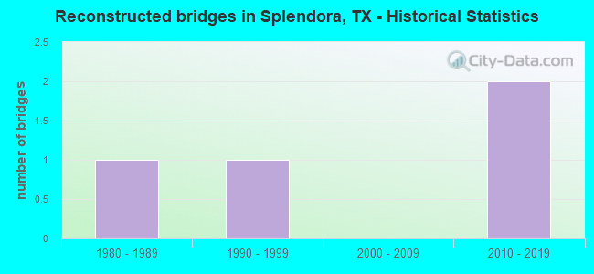
- Reconstructed bridges - Historical Statistics
- 11980-1989
- 11990-1999
- 02000-2009
- 22010-2019
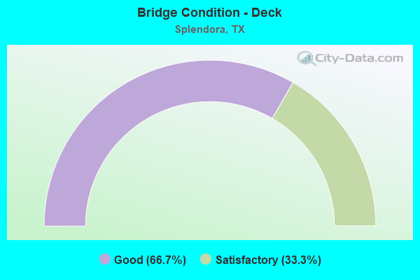
- Bridge Condition - Deck
- 66.7%Good
- 33.3%Satisfactory
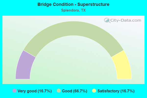
- Bridge Condition - Superstructure
- 16.7%Very good
- 66.7%Good
- 16.7%Satisfactory
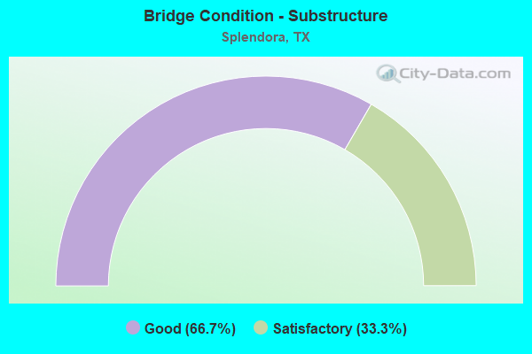
- Bridge Condition - Substructure
- 66.7%Good
- 33.3%Satisfactory
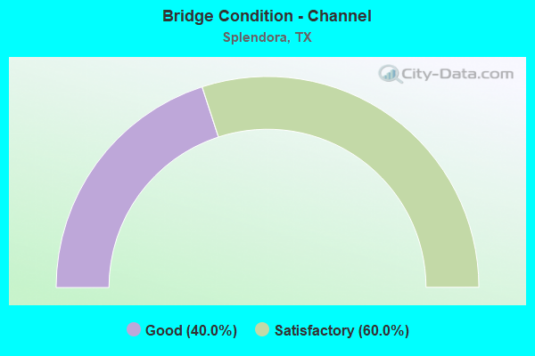
- Bridge Condition - Channel
- 40.0%Good
- 60.0%Satisfactory
Find on map >> Show street view
Structure Number: 12170001770502, Location: 0.5 MI S OF FOSTORIA RD (Lat: 30.262117, Lng: -95.143511), Route carried "on" structure: US 59, Year Built: 1929, Year Reconstructed: 2004, Status: Open, Structure Length: 0.94m (3.08ft), Average Daily Traffic: 43,900 (year 2010), Truck Traffic: 14%, Average Future Daily Traffic: 61,460 (year 2030), Features Intersected: DRAIN
Minimum Vertical Clearance: 30+ m (98+ ft), Kilometerpoint: 1.305, Lanes on structure: 11, Owner: State Highway Agency, Approaching Roadway Width: 61.6m (202.1ft), Skew: 30 degrees, Material/Design: Concrete, Design/Construction: Culvert, Number Of Spans In Main Unit: 6, Length of Maximum Span: 1.2m (3.9ft), Curb-To-Curb Width: 61.6m (202.1ft), Out-to-Out Width: 83.2m (273.0ft)
Condition: Channel: Good, Culverts: Good, Operating Rating: 39.9 metric tons, Method Used To Determine Operating Rating: Load Factor (LF), Inventory Rating: 23.6 metric tons, Method Used To Determine Inventory Rating: Load Factor (LF), Structural Evaluation: Somewhat better than minimum adequacy, Deck Geometry: Superior to present desirable criteria, Waterway Adequacy: Equal to present minimum criteria, Approach Roadway Alignment: Equal to present desirable criteria, Designated Inspection Frequency: Every 24 months, Inspection Date: November 2020, Deck Structure Type: Concrete Cast-file-Place, Wearing Surface/Protective System: Wearing Surface: Bituminous
Find on map >> Show street view
Structure Number: 121700017705324, Location: 0.18 MI N OF FOSTORIA RD (Lat: 30.271294, Lng: -95.137042), Route carried "on" structure: US 59, Year Built: 2004, Status: Open, Structure Length: 1.01m (3.31ft), Average Daily Traffic: 41,770 (year 2016), Truck Traffic: 17%, Average Future Daily Traffic: 69,210 (year 2036), Design Load: HS 20, Features Intersected: DRAIN
Minimum Vertical Clearance: 30+ m (98+ ft), Kilometerpoint: 1.312, Lanes on structure: 10, Owner: State Highway Agency, Approaching Roadway Width: 56.1m (184.1ft), Material/Design: Concrete, Design/Construction: Culvert, Number Of Spans In Main Unit: 4, Length of Maximum Span: 2.1m (6.9ft)
Condition: Channel: Good, Culverts: Good, Operating Rating: 54.4 metric tons, Method Used To Determine Operating Rating: Assigned rating based on Load Factor Design (LFD) reported in metric tons, Inventory Rating: 32.7 metric tons, Method Used To Determine Inventory Rating: Assigned rating based on Load Factor Design (LFD) reported in metric tons, Structural Evaluation: Better than present minimum criteria, Waterway Adequacy: Equal to present minimum criteria, Approach Roadway Alignment: Equal to present desirable criteria, Designated Inspection Frequency: Every 48 months, Inspection Date: December 2020
Find on map >> Show street view
Structure Number: 121700017705538, Location: 3.0 MI NE OF FM 2090 (Lat: 30.269039, Lng: -95.138828), Route carried "on" structure: US 59, Year Built: 2004, Year Reconstructed: 2010, Status: Open, Structure Length: 7.07m (23.20ft), Average Daily Traffic: 42,000 (year 2016), Truck Traffic: 17%, Average Future Daily Traffic: 70,000 (year 2036), Design Load: HS 20, Features Intersected: FOSTORIA ROAD
Minimum Vertical Clearance: 30+ m (98+ ft), Kilometerpoint: 1.312, Lanes on structure: 6, Lanes under structure: 4, Owner: State Highway Agency, Approaching Roadway Width: 36.0m (118.1ft), Skew: 30 degrees, Material/Design: Prestressed concrete, Design/Construction: Stringer/Multi-beam, Number Of Spans In Main Unit: 3, Length of Maximum Span: 28.0m (91.9ft), Curb-To-Curb Width: 36.0m (118.1ft), Out-to-Out Width: 37.4m (122.7ft)
Condition: Deck: Good, Superstructure: Very good, Substructure: Good, Operating Rating: 54.4 metric tons, Method Used To Determine Operating Rating: Assigned rating based on Load Factor Design (LFD) reported in metric tons, Inventory Rating: 32.7 metric tons, Method Used To Determine Inventory Rating: Assigned rating based on Load Factor Design (LFD) reported in metric tons, Structural Evaluation: Better than present minimum criteria, Deck Geometry: Superior to present desirable criteria, Underclear: Superior to present desirable criteria, Approach Roadway Alignment: Equal to present desirable criteria, Designated Inspection Frequency: Every 24 months, Inspection Date: November 2020, Deck Structure Type: Concrete Cast-file-Place
Find on map >> Show street view
Structure Number: 121700017705539, Location: 1.5 MI NE OF FM 2090 (Lat: 30.250631, Lng: -95.151497), Route carried "on" structure: US 59, Year Built: 2004, Year Reconstructed: 2010, Status: Open, Structure Length: 7.07m (23.20ft), Average Daily Traffic: 42,000 (year 2016), Truck Traffic: 17%, Average Future Daily Traffic: 70,000 (year 2036), Design Load: HS 20, Features Intersected: EAST RIVER DRIVE
Minimum Vertical Clearance: 30+ m (98+ ft), Kilometerpoint: 1.299, Lanes on structure: 6, Lanes under structure: 4, Owner: State Highway Agency, Approaching Roadway Width: 36.0m (118.1ft), Skew: 30 degrees, Material/Design: Prestressed concrete, Design/Construction: Stringer/Multi-beam, Number Of Spans In Main Unit: 3, Length of Maximum Span: 28.0m (91.9ft), Curb-To-Curb Width: 36.0m (118.1ft), Out-to-Out Width: 37.4m (122.7ft)
Condition: Deck: Satisfactory, Superstructure: Good, Substructure: Good, Operating Rating: 54.4 metric tons, Method Used To Determine Operating Rating: Assigned rating based on Load Factor Design (LFD) reported in metric tons, Inventory Rating: 32.7 metric tons, Method Used To Determine Inventory Rating: Assigned rating based on Load Factor Design (LFD) reported in metric tons, Structural Evaluation: Better than present minimum criteria, Deck Geometry: Superior to present desirable criteria, Underclear: Superior to present desirable criteria, Approach Roadway Alignment: Equal to present desirable criteria, Designated Inspection Frequency: Every 24 months, Inspection Date: November 2020, Deck Structure Type: Concrete Cast-file-Place
Find on map >> Show street view
Structure Number: 12170001770554, Location: 3.2 MI S OF LIBERTY C/L (Lat: 30.232589, Lng: -95.165119), Route carried "on" structure: US 59, Year Built: 2010, Status: Open, Structure Length: 10.55m (34.61ft), Average Daily Traffic: 40,000 (year 2016), Truck Traffic: 16%, Average Future Daily Traffic: 60,000 (year 2036), Design Load: HL 93, Features Intersected: FM 2090
Minimum Vertical Clearance: 30+ m (98+ ft), Kilometerpoint: 5.176, Lanes on structure: 6, Lanes under structure: 8, Owner: State Highway Agency, Approaching Roadway Width: 36.0m (118.1ft), Skew: 32 degrees, Material/Design: Prestressed concrete, Design/Construction: Stringer/Multi-beam, Number Of Spans In Main Unit: 3, Length of Maximum Span: 35.4m (116.1ft), Curb-To-Curb Width: 36.0m (118.1ft), Out-to-Out Width: 37.3m (122.4ft)
Condition: Deck: Good, Superstructure: Good, Substructure: Good, Operating Rating: 54.4 metric tons, Method Used To Determine Operating Rating: Assigned ratings based on Load and Resistance Factor Design (LRFD) reported in metric tons, Inventory Rating: 32.7 metric tons, Method Used To Determine Inventory Rating: Assigned ratings based on Load and Resistance Factor Design (LRFD) reported in metric tons, Structural Evaluation: Better than present minimum criteria, Deck Geometry: Superior to present desirable criteria, Underclear: Meets minimum limits, Approach Roadway Alignment: Equal to present desirable criteria, Designated Inspection Frequency: Every 24 months, Inspection Date: November 2020, Deck Structure Type: Concrete Cast-file-Place
Find on map >> Show street view
Structure Number: 121700191201003, Location: 0.2 MI W OF US 59 (Lat: 30.232725, Lng: -95.168528), Route carried "on" structure: State highway 2090, Year Built: 1965, Year Reconstructed: 1992, Status: Open, Structure Length: 12.19m (39.99ft), Average Daily Traffic: 7,803 (year 2020), Truck Traffic: 9%, Average Future Daily Traffic: 13,650 (year 2033), Design Load: H 20, Features Intersected: PEACH CREEK
Minimum Vertical Clearance: 30+ m (98+ ft), Kilometerpoint: 47.117, Lanes on structure: 2, Owner: State Highway Agency, Approaching Roadway Width: 12.2m (40.0ft), Material/Design: Concrete, Design/Construction: Stringer/Multi-beam, Number Of Spans In Main Unit: 10, Length of Maximum Span: 12.2m (40.0ft), Curb-To-Curb Width: 13.4m (44.0ft), Out-to-Out Width: 14.3m (46.9ft)
Condition: Deck: Satisfactory, Superstructure: Satisfactory, Substructure: Satisfactory, Channel: Satisfactory, Operating Rating: 54.4 metric tons, Method Used To Determine Operating Rating: Assigned rating based on Load Factor Design (LFD) reported in metric tons, Inventory Rating: 32.7 metric tons, Method Used To Determine Inventory Rating: Assigned rating based on Load Factor Design (LFD) reported in metric tons, Structural Evaluation: Equal to present minimum criteria, Deck Geometry: Equal to present minimum criteria, Waterway Adequacy: Equal to present minimum criteria, Approach Roadway Alignment: Equal to present desirable criteria, Designated Inspection Frequency: Every 24 months, Inspection Date: October 2020, Deck Structure Type: Concrete Cast-file-Place
Find on map >> Show street view
Structure Number: 121700AA1956001, Location: 0.25 MI S OF FM 2090 (Lat: 30.230683, Lng: -95.172506), Route carried "on" structure: County highway , Year Built: 1987, Status: Open, Structure Length: 2.47m (8.10ft), Average Daily Traffic: 410 (year 2015), Truck Traffic: 1%, Average Future Daily Traffic: 1,000 (year 2035), Features Intersected: GULLY BRANCH, Facility Carried by Structure: DUKE RD
Minimum Vertical Clearance: 30+ m (98+ ft), Kilometerpoint: 0.483, Lanes on structure: 2, Owner: County Highway Agency, Approaching Roadway Width: 6.1m (20.0ft), Material/Design: Steel, Number Of Spans In Main Unit: 1, Length of Maximum Span: 24.1m (79.1ft), Curb-To-Curb Width: 7.8m (25.6ft), Out-to-Out Width: 7.9m (25.9ft)
Condition: Deck: Good, Superstructure: Good, Substructure: Good, Channel: Satisfactory, Operating Rating: 40.8 metric tons, Method Used To Determine Operating Rating: Allowable Stress (AS), Inventory Rating: 24.5 metric tons, Method Used To Determine Inventory Rating: Allowable Stress (AS), Structural Evaluation: Equal to present minimum criteria, Deck Geometry: Meets minimum limits, Waterway Adequacy: Better than present minimum criteria, Approach Roadway Alignment: Equal to present desirable criteria, Length Of Structure Improvement: 3.26m (10.70ft), Designated Inspection Frequency: Every 24 months, Inspection Date: September 2021, Bridge Improvement Cost: $97,000, Roadway Improvement Cost: $24,000, Total Project Cost: $121,000, Deck Structure Type: Concrete Cast-file-Place
Find on map >> Show street view
Structure Number: 121700AA1968001, Location: 0.25 MI SW OF FM 2090 (Lat: 30.239528, Lng: -95.186656), Route carried "on" structure: County highway , Year Built: 1989, Status: Open, Structure Length: 1.28m (4.20ft), Average Daily Traffic: 50 (year 2015), Average Future Daily Traffic: 100 (year 2035), Features Intersected: GULLY BRANCH, Facility Carried by Structure: DRIVERS DR
Minimum Vertical Clearance: 30+ m (98+ ft), Kilometerpoint: 0.483, Lanes on structure: 2, Owner: County Highway Agency, Approaching Roadway Width: 3.7m (12.1ft), Material/Design: Steel, Number Of Spans In Main Unit: 1, Length of Maximum Span: 11.9m (39.0ft), Curb-To-Curb Width: 7.8m (25.6ft), Out-to-Out Width: 7.9m (25.9ft)
Condition: Deck: Good, Superstructure: Good, Substructure: Satisfactory, Channel: Satisfactory, Operating Rating: 57.1 metric tons, Method Used To Determine Operating Rating: Allowable Stress (AS), Inventory Rating: 39.0 metric tons, Method Used To Determine Inventory Rating: Allowable Stress (AS), Structural Evaluation: Equal to present minimum criteria, Deck Geometry: Equal to present minimum criteria, Waterway Adequacy: Better than present minimum criteria, Approach Roadway Alignment: Equal to present desirable criteria, Designated Inspection Frequency: Every 24 months, Inspection Date: October 2021, Deck Structure Type: Concrete Cast-file-Place
Find on map >> Show street view
Structure Number: 121700017705538, Location: 3.0 MI NE OF FM 2090 (Lat: 30.268981, Lng: -95.138608), Route carried "under" structure: County highway , Year Built: 2004, Structure Length: 0. m, Average Daily Traffic: 4,000 (year 2016), Truck Traffic: 5%, Features Intersected: US 59, Facility Carried by Structure: US 59
Minimum Vertical Clearance: 5.21m (17.09ft), Kilometerpoint: 1.312, Lanes on structure: 2, Material/Design: Prestressed concrete, Design/Construction: Stringer/Multi-beam, Length of Maximum Span: 28.0m (91.9ft)
Find on map >> Show street view
Structure Number: 121700017705539, Location: 1.5 MI NE OF FM 2090 (Lat: 30.250531, Lng: -95.151278), Route carried "under" structure: County highway , Year Built: 2004, Structure Length: 0. m, Average Daily Traffic: 4,000 (year 2016), Truck Traffic: 5%, Features Intersected: US 59, Facility Carried by Structure: US 59
Minimum Vertical Clearance: 5.31m (17.42ft), Kilometerpoint: 1.299, Lanes on structure: 2, Material/Design: Prestressed concrete, Design/Construction: Stringer/Multi-beam, Length of Maximum Span: 28.0m (91.9ft)
Find on map >> Show street view
Structure Number: 12170001770554, Location: 3.2 MI S OF LIBERTY C/L (Lat: 30.232567, Lng: -95.164842), Route carried "under" structure: State highway 2090, Year Built: 2010, Structure Length: 0. m, Average Daily Traffic: 10,000 (year 2016), Truck Traffic: 5%, Features Intersected: US 59, Facility Carried by Structure: US 59
Minimum Vertical Clearance: 5.49m (18.01ft), Kilometerpoint: 47.563, Lanes on structure: 6, Material/Design: Prestressed concrete, Design/Construction: Stringer/Multi-beam, Length of Maximum Span: 35.4m (116.1ft)