Bridge Statistics for Spinnerstown, Pennsylvania (PA)
Condition, Traffic, Stress, Structural Evaluation, Project Costs
- National Bridge Inventory (NBI) Statistics
- 12Number of bridges
- 59ft / 18.0mTotal length
- $947,000Total costs
- 196,500Total average daily traffic
- 29,666Total average daily truck traffic
- National Bridge Inventory (NBI) Registered Bridges for Spinnerstown
- No street view available for this location
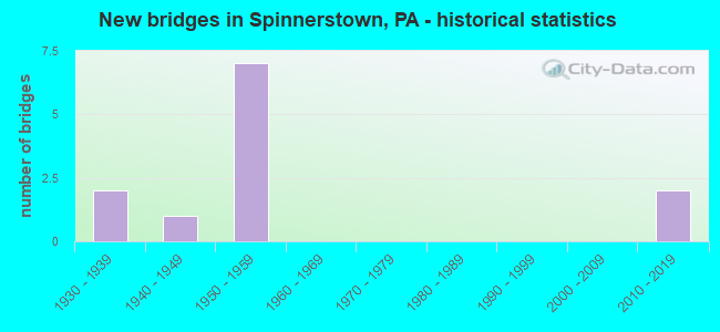
- New bridges - historical statistics
- 21930-1939
- 11940-1949
- 71950-1959
- 22010-2019


- Bridge Condition - Deck
- 25.0%Very good
- 12.5%Good
- 37.5%Satisfactory
- 25.0%Fair

- Bridge Condition - Superstructure
- 25.0%Very good
- 37.5%Satisfactory
- 37.5%Fair

- Bridge Condition - Substructure
- 25.0%Very good
- 50.0%Satisfactory
- 25.0%Fair

- Bridge Condition - Channel
- 25.0%Very good
- 25.0%Fair
- 50.0%Poor
Find on map >> Show street view
Structure Number: 7432, Location: EAST OF PENNA.TPK. 06H12 (Lat: 40.452172, Lng: -75.429675), Route carried "on" structure: State highway , Year Built: 1946, Status: Open, Structure Length: 0.82m (2.69ft), Average Daily Traffic: 1,793 (year 2020), Truck Traffic: 8%, Average Future Daily Traffic: 2,083 (year 2032), Design Load: HS 20, Features Intersected: LICKING CREEK, Facility Carried by Structure: STEINSBURG ROAD
Minimum Vertical Clearance: 30+ m (98+ ft), Kilometerpoint: 1.590, Lanes on structure: 2, Owner: State Highway Agency, Approaching Roadway Width: 6.4m (21.0ft), Skew: 1 degrees, Material/Design: Concrete, Design/Construction: Tee Beam, Number Of Spans In Main Unit: 1, Length of Maximum Span: 7.9m (25.9ft), Curb or Sidewalk Widths: Left: 0.2m (0.7ft), Right: 0.2m (0.7ft), Curb-To-Curb Width: 9.1m (29.9ft), Out-to-Out Width: 10.2m (33.5ft)
Condition: Deck: Good, Superstructure: Satisfactory, Substructure: Satisfactory, Channel: Fair, Operating Rating: 58.1 metric tons, Method Used To Determine Operating Rating: Load Factor (LF), Inventory Rating: 34.5 metric tons, Method Used To Determine Inventory Rating: Load Factor (LF), Structural Evaluation: Equal to present minimum criteria, Deck Geometry: Somewhat better than minimum adequacy, Waterway Adequacy: Better than present minimum criteria, Approach Roadway Alignment: Equal to present desirable criteria, Length Of Structure Improvement: 1.40m (4.59ft), Designated Inspection Frequency: Every 24 months, Inspection Date: December 2020, Deck Structure Type: Concrete Cast-file-Place, Wearing Surface/Protective System: Wearing Surface: Bituminous
Find on map >> Show street view
Structure Number: 7434, Location: STEINSBURG; MILFRD.06J09 (Lat: 40.466667, Lng: -75.416778), Route carried "on" structure: State highway , Year Built: 1933, Status: Open, Structure Length: 0.98m (3.22ft), Average Daily Traffic: 796 (year 2022), Truck Traffic: 9%, Average Future Daily Traffic: 1,094 (year 2032), Design Load: H 20, Features Intersected: BRANCH OF UNAMI CREEK, Facility Carried by Structure: ROSEDALE ROAD
Minimum Vertical Clearance: 30+ m (98+ ft), Kilometerpoint: 3.655, Lanes on structure: 2, Owner: State Highway Agency, Approaching Roadway Width: 5.2m (17.1ft), Material/Design: Steel, Design/Construction: Stringer/Multi-beam, Number Of Spans In Main Unit: 1, Length of Maximum Span: 8.8m (28.9ft), Curb-To-Curb Width: 5.3m (17.4ft), Out-to-Out Width: 6.1m (20.0ft)
Condition: Deck: Satisfactory, Superstructure: Fair, Substructure: Fair, Channel: Poor, Operating Rating: 75.3 metric tons, Method Used To Determine Operating Rating: Load Factor (LF), Inventory Rating: 45.4 metric tons, Method Used To Determine Inventory Rating: Load Factor (LF), Structural Evaluation: Somewhat better than minimum adequacy, Deck Geometry: High priority of replacement, Waterway Adequacy: Better than present minimum criteria, Approach Roadway Alignment: Equal to present desirable criteria, Length Of Structure Improvement: 1.20m (3.94ft), Designated Inspection Frequency: Every 24 months, Inspection Date: Febuary 2021, Bridge Improvement Cost: $25,000, Roadway Improvement Cost: $105,000, Total Project Cost: $333,000, Deck Structure Type: Concrete Cast-file-Place, Wearing Surface/Protective System: Wearing Surface: Bituminous
Find on map >> Show street view
Structure Number: 23305, Location: LIMEPORT PIKE (Lat: 40.457342, Lng: -75.485786), Route carried "on" structure: State highway , Year Built: 1933, Year Reconstructed: 1965, Status: Open, Structure Length: 0.88m (2.89ft), Average Daily Traffic: 2,650 (year 2022), Truck Traffic: 5%, Average Future Daily Traffic: 2,674 (year 2032), Design Load: HS 20, Features Intersected: HOSENSACK CREEK, Facility Carried by Structure: SR 2029(LR.39002)
Minimum Vertical Clearance: 30+ m (98+ ft), Kilometerpoint: 3.943, Lanes on structure: 2, Owner: State Highway Agency, Approaching Roadway Width: 6.1m (20.0ft), Skew: 3 degrees, Material/Design: Steel, Design/Construction: Stringer/Multi-beam, Number Of Spans In Main Unit: 1, Length of Maximum Span: 8.2m (26.9ft), Curb-To-Curb Width: 6.0m (19.7ft), Out-to-Out Width: 6.5m (21.3ft)
Condition: Deck: Fair, Superstructure: Fair, Substructure: Satisfactory, Channel: Poor, Operating Rating: 46.3 metric tons, Method Used To Determine Operating Rating: Load Factor (LF), Inventory Rating: 28.1 metric tons, Method Used To Determine Inventory Rating: Load Factor (LF), Structural Evaluation: Somewhat better than minimum adequacy, Deck Geometry: High priority of replacement, Waterway Adequacy: Better than present minimum criteria, Approach Roadway Alignment: Somewhat better than minimum adequacy, Length Of Structure Improvement: 1.60m (5.25ft), Designated Inspection Frequency: Every 24 months, Inspection Date: September 2020, Bridge Improvement Cost: $2,000, Roadway Improvement Cost: $7,000, Total Project Cost: $30,000, Deck Structure Type: Open Grating
Find on map >> Show street view
Structure Number: 23535, Location: 1 MI N OF BUCKS CO. LINE (Lat: 40.463047, Lng: -75.446714), Route carried "on" structure: City street , Year Built: 1955, Status: Open, Structure Length: 4.75m (15.58ft), Average Daily Traffic: 200 (year 1992), Truck Traffic: 3%, Average Future Daily Traffic: 315 (year 2030), Design Load: HS 20, Features Intersected: PA TPK (I-476), Facility Carried by Structure: T-383, Cassel Rd
Minimum Vertical Clearance: 30+ m (98+ ft), Kilometerpoint: 0.000, Lanes on structure: 2, Lanes under structure: 4, Owner: State Toll Authority, Approaching Roadway Width: 6.1m (20.0ft), Skew: 1 degrees, Material/Design: Steel continuous, Design/Construction: Stringer/Multi-beam, Number Of Spans In Main Unit: 3, Length of Maximum Span: 24.4m (80.1ft), Curb or Sidewalk Widths: Left: 0.5m (1.6ft), Right: 0.5m (1.6ft), Curb-To-Curb Width: 7.9m (25.9ft), Out-to-Out Width: 9.7m (31.8ft)
Condition: Deck: Fair, Superstructure: Satisfactory, Substructure: Satisfactory, Operating Rating: 68.0 metric tons, Method Used To Determine Operating Rating: Load and Resistance Factor (LRFR), Inventory Rating: 52.6 metric tons, Method Used To Determine Inventory Rating: Load and Resistance Factor (LRFR), Structural Evaluation: Equal to present minimum criteria, Deck Geometry: Somewhat better than minimum adequacy, Underclear: High priority of corrective action, Approach Roadway Alignment: Equal to present desirable criteria, Length Of Structure Improvement: 5.70m (18.70ft), Designated Inspection Frequency: Every 24 months, Critical Feature Inspection Frequency: Every 24 months, Inspection Date: March 2021, Critical Feature Inspection Date: March 2021, Deck Structure Type: Concrete Cast-file-Place, Wearing Surface/Protective System: Wearing Surface: Monolithic Concrete
Find on map >> Show street view
Structure Number: 23536, Location: 1.5 MI N OF BUCKS CO LINE (Lat: 40.471822, Lng: -75.454033), Route carried "on" structure: Other road 476, Year Built: 1955, Status: Open, Structure Length: 0.82m (2.69ft), Average Daily Traffic: 44,406 (year 2004), Truck Traffic: 16%, Average Future Daily Traffic: 71,429 (year 2030), Design Load: HS 20, Features Intersected: T-392
Minimum Vertical Clearance: 30+ m (98+ ft), Kilometerpoint: 0.000, Lanes on structure: 4, Lanes under structure: 2, Base Highway Network: Yes, Toll: On toll road, Owner: State Toll Authority, Approaching Roadway Width: 23.2m (76.1ft), Skew: 30 degrees, Material/Design: Concrete, Design/Construction: Tee Beam, Number Of Spans In Main Unit: 1, Length of Maximum Span: 7.3m (24.0ft), Curb or Sidewalk Widths: Left: 0.1m (0.3ft), Right: 0.1m (0.3ft), Curb-To-Curb Width: 18.3m (60.0ft), Out-to-Out Width: 21.0m (68.9ft)
Condition: Deck: Satisfactory, Superstructure: Satisfactory, Substructure: Satisfactory, Operating Rating: 54.4 metric tons, Method Used To Determine Operating Rating: Allowable Stress (AS), Inventory Rating: 36.3 metric tons, Method Used To Determine Inventory Rating: Allowable Stress (AS), Structural Evaluation: Equal to present minimum criteria, Deck Geometry: Meets minimum limits, Underclear: High priority of corrective action, Approach Roadway Alignment: Equal to present desirable criteria, Length Of Structure Improvement: 1.40m (4.59ft), Designated Inspection Frequency: Every 24 months, Inspection Date: September 2019, Bridge Improvement Cost: $7,000, Roadway Improvement Cost: $21,000, Total Project Cost: $96,000, Deck Structure Type: Concrete Cast-file-Place, Wearing Surface/Protective System: Wearing Surface: Latex Concrete
Find on map >> Show street view
Structure Number: 23537, Location: 2 MI N OF BUCKS CO LINE (Lat: 40.481000, Lng: -75.461194), Route carried "on" structure: Interstate 476, Year Built: 1955, Status: Open, Structure Length: 3.23m (10.60ft), Average Daily Traffic: 44,406 (year 2004), Truck Traffic: 16%, Average Future Daily Traffic: 71,429 (year 2030), Design Load: HS 20, Features Intersected: SR 2029, LR39002
Minimum Vertical Clearance: 30+ m (98+ ft), Kilometerpoint: 0.000, Lanes on structure: 4, Lanes under structure: 2, Base Highway Network: Yes, Toll: On toll road, Owner: State Toll Authority, Approaching Roadway Width: 22.6m (74.1ft), Skew: 32 degrees, Material/Design: Steel continuous, Design/Construction: Stringer/Multi-beam, Number Of Spans In Main Unit: 3, Length of Maximum Span: 12.8m (42.0ft), Curb or Sidewalk Widths: Left: 0.5m (1.6ft), Right: 0.5m (1.6ft), Curb-To-Curb Width: 16.5m (54.1ft), Out-to-Out Width: 19.4m (63.6ft)
Condition: Deck: Satisfactory, Superstructure: Fair, Substructure: Fair, Operating Rating: 58.1 metric tons, Method Used To Determine Operating Rating: Load Factor (LF), Inventory Rating: 34.5 metric tons, Method Used To Determine Inventory Rating: Load Factor (LF), Structural Evaluation: Somewhat better than minimum adequacy, Deck Geometry: High priority of replacement, Underclear: Meets minimum limits, Approach Roadway Alignment: Equal to present desirable criteria, Length Of Structure Improvement: 4.00m (13.12ft), Designated Inspection Frequency: Every 24 months, Inspection Date: March 2021, Bridge Improvement Cost: $36,000, Roadway Improvement Cost: $107,000, Total Project Cost: $488,000, Deck Structure Type: Concrete Cast-file-Place, Wearing Surface/Protective System: Wearing Surface: Latex Concrete
Find on map >> Show street view
Structure Number: 46185, Location: 1 mi SW Dillingersville (Lat: 40.470794, Lng: -75.466583), Route carried "on" structure: State highway , Year Built: 2010, Status: Open, Structure Length: 1.58m (5.18ft), Average Daily Traffic: 2,303 (year 2020), Truck Traffic: 8%, Average Future Daily Traffic: 2,957 (year 2032), Design Load: HL 93, Features Intersected: Hosensack Creek, Facility Carried by Structure: SR 2031
Minimum Vertical Clearance: 30+ m (98+ ft), Kilometerpoint: 2.863, Lanes on structure: 2, Owner: State Highway Agency, Approaching Roadway Width: 7.9m (25.9ft), Material/Design: Prestressed concrete, Design/Construction: Box Beam or Girders - Single/Spread, Number Of Spans In Main Unit: 1, Length of Maximum Span: 15.2m (49.9ft), Curb or Sidewalk Widths: Left: 0.1m (0.3ft), Right: 0.1m (0.3ft), Curb-To-Curb Width: 7.9m (25.9ft), Out-to-Out Width: 9.3m (30.5ft)
Condition: Deck: Very good, Superstructure: Very good, Substructure: Very good, Channel: Very good, Operating Rating: 76.2 metric tons, Method Used To Determine Operating Rating: Load and Resistance Factor (LRFR), Inventory Rating: 41.7 metric tons, Method Used To Determine Inventory Rating: Load and Resistance Factor (LRFR), Structural Evaluation: Equal to present desirable criteria, Deck Geometry: High priority of corrective action, Waterway Adequacy: Equal to present desirable criteria, Approach Roadway Alignment: Meets minimum limits, Designated Inspection Frequency: Every 48 months, Inspection Date: December 2018, Deck Structure Type: Concrete Cast-file-Place, Wearing Surface/Protective System: Wearing Surface: Monolithic Concrete, Deck Protection: Epoxy Coated Reinforcing
Find on map >> Show street view
Structure Number: 54782, Location: 3/4 MI. N. PA663 2694A10 (Lat: 40.444150, Lng: -75.430917), Route carried "on" structure: State highway , Year Built: 2017, Status: Open, Structure Length: 4.97m (16.31ft), Average Daily Traffic: 1,793 (year 2020), Truck Traffic: 8%, Average Future Daily Traffic: 2,061 (year 2030), Design Load: HL 93, Features Intersected: PA TPK (TOLL 476), Facility Carried by Structure: STEINSBURG ROAD
Minimum Vertical Clearance: 30+ m (98+ ft), Kilometerpoint: 0.000, Lanes on structure: 2, Lanes under structure: 4, Owner: State Highway Agency, Approaching Roadway Width: 9.1m (29.9ft), Skew: 3 degrees, Material/Design: Prestressed concrete continuous, Design/Construction: Stringer/Multi-beam, Number Of Spans In Main Unit: 2, Length of Maximum Span: 24.7m (81.0ft), Curb or Sidewalk Widths: Left: 0.2m (0.7ft), Right: 0.2m (0.7ft), Curb-To-Curb Width: 9.1m (29.9ft), Out-to-Out Width: 10.1m (33.1ft)
Condition: Deck: Very good, Superstructure: Very good, Substructure: Very good, Operating Rating: 47.6 metric tons, Method Used To Determine Operating Rating: Assigned ratings based on Load and Resistance Factor Design (LRFD) reported by rating factor (RF) using HL93 loadings, Inventory Rating: 36.9 metric tons, Method Used To Determine Inventory Rating: Assigned ratings based on Load and Resistance Factor Design (LRFD) reported by rating factor (RF) using HL93 loadings, Structural Evaluation: Equal to present desirable criteria, Deck Geometry: Somewhat better than minimum adequacy, Underclear: Better than present minimum criteria, Approach Roadway Alignment: Equal to present desirable criteria, Designated Inspection Frequency: Every 24 months, Inspection Date: November 2019, Deck Structure Type: Concrete Cast-file-Place, Wearing Surface/Protective System: Wearing Surface: Monolithic Concrete, Deck Protection: Epoxy Coated Reinforcing
Find on map >> Show street view
Structure Number: 7708, Location: QUAKERTOWN INTERCHANGE (Lat: 40.438114, Lng: -75.426244), Route carried "under" structure: Interstate 476, Year Built: 1955, Structure Length: 0. m, Average Daily Traffic: 50,307 (year 2004), Truck Traffic: 15%, Features Intersected: PA TPK (I-476), Facility Carried by Structure: PA TPK. RAMP AB
Minimum Vertical Clearance: 4.47m (14.67ft), Kilometerpoint: 0.000, Lanes on structure: 2, Lanes under structure: 5, Toll: On toll road, Material/Design: Steel continuous, Design/Construction: Stringer/Multi-beam, Length of Maximum Span: 22.3m (73.2ft)
Find on map >> Show street view
Structure Number: 23535, Location: 1 MI N OF BUCKS CO. LINE (Lat: 40.463047, Lng: -75.446714), Route carried "under" structure: Other road 476, Year Built: 1955, Structure Length: 0. m, Average Daily Traffic: 44,406 (year 2004), Truck Traffic: 16%, Features Intersected: PA TPK (I-476), Facility Carried by Structure: T-383, Cassel Rd
Minimum Vertical Clearance: 7.39m (24.25ft), Kilometerpoint: 0.000, Lanes on structure: 2, Lanes under structure: 4, Material/Design: Steel continuous, Design/Construction: Stringer/Multi-beam, Length of Maximum Span: 24.4m (80.1ft)
Find on map >> Show street view
Structure Number: 23536, Location: 1.5 MI N OF BUCKS CO LINE (Lat: 40.471822, Lng: -75.454033), Route carried "under" structure: City street , Year Built: 1955, Structure Length: 0. m, Average Daily Traffic: 200 (year 1992), Features Intersected: T-392, Facility Carried by Structure: PA TPK (I-476)
Minimum Vertical Clearance: 4.37m (14.34ft), Kilometerpoint: 0.000, Lanes on structure: 4, Lanes under structure: 2, Toll: On toll road, Material/Design: Concrete, Design/Construction: Tee Beam, Length of Maximum Span: 7.3m (24.0ft)
Find on map >> Show street view
Structure Number: 23537, Location: 2 MI N OF BUCKS CO LINE (Lat: 40.481000, Lng: -75.461194), Route carried "under" structure: State highway , Year Built: 1955, Structure Length: 0. m, Average Daily Traffic: 3,240 (year 2022), Truck Traffic: 4%, Features Intersected: SR 2029, LR39002, Facility Carried by Structure: PA TPK (I-476)
Minimum Vertical Clearance: 5.21m (17.09ft), Kilometerpoint: 7.475, Lanes on structure: 4, Lanes under structure: 2, Material/Design: Steel continuous, Design/Construction: Stringer/Multi-beam, Length of Maximum Span: 12.8m (42.0ft)