Bridge Statistics for Speers, Pennsylvania (PA)
Condition, Traffic, Stress, Structural Evaluation, Project Costs
- National Bridge Inventory (NBI) Statistics
- 10Number of bridges
- 246ft / 75.1mTotal length
- $25,041,000Total costs
- 102,808Total average daily traffic
- 24,829Total average daily truck traffic
- National Bridge Inventory (NBI) Registered Bridges for Speers
- No street view available for this location
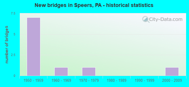
- New bridges - historical statistics
- 71950-1959
- 11960-1969
- 11970-1979
- 12000-2009


- Bridge Condition - Deck
- 40.0%Good
- 40.0%Satisfactory
- 20.0%Poor

- Bridge Condition - Superstructure
- 20.0%Good
- 40.0%Satisfactory
- 20.0%Fair
- 20.0%Poor

- Bridge Condition - Substructure
- 40.0%Good
- 20.0%Satisfactory
- 40.0%Poor

- Bridge Condition - Channel
- 66.7%Good
- 33.3%Fair
Find on map >> Show street view
Structure Number: 34533, Location: BELLE VERNON BRIDGE (Lat: 40.126078, Lng: -79.878550), Route carried "on" structure: Interstate 70, Year Built: 1951, Year Reconstructed: 1993, Status: Open, Structure Length: 62.97m (206.59ft), Average Daily Traffic: 41,915 (year 2022), Truck Traffic: 28%, Average Future Daily Traffic: 49,812 (year 2032), Design Load: HS 20+Mod, Features Intersected: 0088, 0906, 2 R/R, MON
Minimum Vertical Clearance: 6.22m (20.41ft), Kilometerpoint: 64.435, Lanes on structure: 2, Lanes under structure: 8, Base Highway Network: Yes, Owner: State Highway Agency, Approaching Roadway Width: 22.9m (75.1ft), Skew: 30 degrees, Navigation Control: Yes ( Vertical Clearance: 999.7m (3,279.9ft), Horizontal Clearance: 9999.9m (32,808.1ft)), Material/Design: Steel continuous, Design/Construction: Truss - Thru, Number Of Spans In Main Unit: 3, Number Of Approach Spans: 9, Length of Maximum Span: 137.2m (450.1ft), Curb or Sidewalk Widths: Left: 0.0m, Right: 1.7m (5.6ft), Curb-To-Curb Width: 16.2m (53.1ft), Out-to-Out Width: 17.4m (57.1ft)
Condition: Deck: Satisfactory, Superstructure: Fair, Substructure: Good, Channel: Good, Operating Rating: 41.7 metric tons, Method Used To Determine Operating Rating: Load Factor (LF), Inventory Rating: 25.4 metric tons, Method Used To Determine Inventory Rating: Load Factor (LF), Structural Evaluation: Somewhat better than minimum adequacy, Deck Geometry: Superior to present desirable criteria, Underclear: Equal to present minimum criteria, Waterway Adequacy: Superior to present desirable criteria, Approach Roadway Alignment: Equal to present desirable criteria, Length Of Structure Improvement: 63.10m (207.02ft), Designated Inspection Frequency: Every 24 months, Critical Feature Inspection Frequency: Every 24 months, Underwater Inspection Frequency: Every 60 months, Inspection Date: September 2021, Critical Feature Inspection Date: September 2021, Underwater Inspection Date: September 2018, Bridge Improvement Cost: $1,803,000, Roadway Improvement Cost: $5,311,000, Total Project Cost: $24,345,000, Deck Structure Type: Concrete Cast-file-Place, Wearing Surface/Protective System: Wearing Surface: Epoxy Overlay, Deck Protection: Epoxy Coated Reinforcing
Find on map >> Show street view
Structure Number: 34963, Location: SPEERS BOROUGH (Lat: 40.119569, Lng: -79.885019), Route carried "on" structure: State highway , Year Built: 1958, Status: Open, Structure Length: 4.45m (14.60ft), Average Daily Traffic: 3,852 (year 2020), Truck Traffic: 11%, Average Future Daily Traffic: 5,675 (year 2032), Design Load: HS 20+Mod, Features Intersected: SR 0070, Facility Carried by Structure: SR 2027
Minimum Vertical Clearance: 30+ m (98+ ft), Kilometerpoint: 5.016, Lanes on structure: 2, Lanes under structure: 8, Owner: State Highway Agency, Approaching Roadway Width: 7.9m (25.9ft), Material/Design: Prestressed concrete, Design/Construction: Box Beam or Girders - Multiple, Number Of Spans In Main Unit: 3, Length of Maximum Span: 22.6m (74.1ft), Curb or Sidewalk Widths: Left: 0.2m (0.7ft), Right: 0.2m (0.7ft), Curb-To-Curb Width: 12.2m (40.0ft), Out-to-Out Width: 13.3m (43.6ft)
Condition: Deck: Poor, Superstructure: Poor, Substructure: Poor, Operating Rating: 95.3 metric tons, Method Used To Determine Operating Rating: Load Factor (LF), Inventory Rating: 34.5 metric tons, Method Used To Determine Inventory Rating: Load Factor (LF), Structural Evaluation: Meets minimum limits, Deck Geometry: Equal to present minimum criteria, Underclear: High priority of corrective action, Approach Roadway Alignment: Equal to present desirable criteria, Length Of Structure Improvement: 5.40m (17.72ft), Designated Inspection Frequency: Every 24 months, Inspection Date: May 2020, Bridge Improvement Cost: $34,000, Roadway Improvement Cost: $100,000, Total Project Cost: $458,000, Deck Structure Type: Concrete Cast-file-Place, Wearing Surface/Protective System: Wearing Surface: Bituminous
Find on map >> Show street view
Structure Number: 34966, Location: SPEERS BOROUGH (Lat: 40.130908, Lng: -79.895578), Route carried "on" structure: State highway , Year Built: 1967, Status: Open, Structure Length: 1.40m (4.59ft), Average Daily Traffic: 3,852 (year 2020), Truck Traffic: 11%, Average Future Daily Traffic: 5,675 (year 2032), Design Load: HS 20, Features Intersected: MAPLE CREEK, Facility Carried by Structure: SR 2027
Minimum Vertical Clearance: 30+ m (98+ ft), Kilometerpoint: 7.165, Lanes on structure: 2, Owner: State Highway Agency, Approaching Roadway Width: 11.6m (38.1ft), Skew: 4 degrees, Material/Design: Prestressed concrete, Design/Construction: Box Beam or Girders - Single/Spread, Number Of Spans In Main Unit: 1, Length of Maximum Span: 13.4m (44.0ft), Curb or Sidewalk Widths: Left: 0.5m (1.6ft), Right: 0.5m (1.6ft), Curb-To-Curb Width: 11.6m (38.1ft), Out-to-Out Width: 13.3m (43.6ft)
Condition: Deck: Good, Superstructure: Satisfactory, Substructure: Satisfactory, Channel: Fair, Operating Rating: 45.4 metric tons, Method Used To Determine Operating Rating: Load Factor (LF), Inventory Rating: 27.2 metric tons, Method Used To Determine Inventory Rating: Load Factor (LF), Structural Evaluation: Equal to present minimum criteria, Deck Geometry: Somewhat better than minimum adequacy, Waterway Adequacy: Superior to present desirable criteria, Approach Roadway Alignment: Equal to present desirable criteria, Length Of Structure Improvement: 1.40m (4.59ft), Designated Inspection Frequency: Every 24 months, Inspection Date: May 2020, Bridge Improvement Cost: $18,000, Roadway Improvement Cost: $100,000, Total Project Cost: $238,000, Deck Structure Type: Concrete Cast-file-Place, Wearing Surface/Protective System: Wearing Surface: Bituminous, Membrane: Preformed Fabric
Find on map >> Show street view
Structure Number: 3539, Location: 800' NORTH OF SR 2027 (Lat: 40.122356, Lng: -79.884533), Route carried "on" structure: City street R0T, Year Built: 1977, Status: Open, Structure Length: 4.69m (15.39ft), Average Daily Traffic: 350 (year 2002), Truck Traffic: 4%, Average Future Daily Traffic: 500 (year 2010), Design Load: HS 20, Features Intersected: WHEELING & LAKE ERIE RR, Facility Carried by Structure: ARENTZEN BLVD
Minimum Vertical Clearance: 30+ m (98+ ft), Kilometerpoint: 0.000, Lanes on structure: 2, Owner: City or Municipal Highway Agency, Approaching Roadway Width: 9.1m (29.9ft), Skew: 3 degrees, Material/Design: Prestressed concrete, Design/Construction: Box Beam or Girders - Multiple, Number Of Spans In Main Unit: 3, Length of Maximum Span: 19.5m (64.0ft), Curb or Sidewalk Widths: Left: 1.5m (4.9ft), Right: 0.2m (0.7ft), Curb-To-Curb Width: 9.1m (29.9ft), Out-to-Out Width: 11.1m (36.4ft)
Condition: Deck: Satisfactory, Superstructure: Satisfactory, Substructure: Poor, Operating Rating: 63.5 metric tons, Method Used To Determine Operating Rating: Load Factor (LF), Inventory Rating: 32.7 metric tons, Method Used To Determine Inventory Rating: Load Factor (LF), Structural Evaluation: Meets minimum limits, Deck Geometry: Equal to present minimum criteria, Underclear: High priority of corrective action, Approach Roadway Alignment: Equal to present desirable criteria, Length Of Structure Improvement: 5.60m (18.37ft), Designated Inspection Frequency: Every 24 months, Inspection Date: October 2020, Deck Structure Type: Concrete Cast-file-Place, Wearing Surface/Protective System: Wearing Surface: Monolithic Concrete, Deck Protection: Galvanized Reinforcing
Find on map >> Show street view
Structure Number: 42025, Location: WEBSTER RD. AT FLOUR MILL (Lat: 40.130597, Lng: -79.896203), Route carried "on" structure: City street , Year Built: 2002, Status: Open, Structure Length: 1.55m (5.09ft), Average Daily Traffic: 75 (year 2017), Truck Traffic: 3%, Average Future Daily Traffic: 75 (year 2037), Design Load: HL 93, Features Intersected: MAPLE CREEK, Facility Carried by Structure: WEBSTER AVENUE
Minimum Vertical Clearance: 30+ m (98+ ft), Kilometerpoint: 0.000, Lanes on structure: 1, Owner: County Highway Agency, Approaching Roadway Width: 5.5m (18.0ft), Material/Design: Prestressed concrete, Design/Construction: Box Beam or Girders - Multiple, Number Of Spans In Main Unit: 1, Length of Maximum Span: 15.2m (49.9ft), Curb or Sidewalk Widths: Left: 0.2m (0.7ft), Right: 0.2m (0.7ft), Curb-To-Curb Width: 5.5m (18.0ft), Out-to-Out Width: 6.3m (20.7ft)
Condition: Deck: Good, Superstructure: Good, Substructure: Good, Channel: Good, Operating Rating: 60.8 metric tons, Method Used To Determine Operating Rating: Load and Resistance Factor (LRFR), Inventory Rating: 42.6 metric tons, Method Used To Determine Inventory Rating: Load and Resistance Factor (LRFR), Structural Evaluation: Better than present minimum criteria, Deck Geometry: Meets minimum limits, Waterway Adequacy: Better than present minimum criteria, Approach Roadway Alignment: Equal to present desirable criteria, Designated Inspection Frequency: Every 24 months, Inspection Date: July 2021, Wearing Surface/Protective System: Wearing Surface: Monolithic Concrete, Deck Protection: Epoxy Coated Reinforcing
Find on map >> Show street view
Structure Number: 34533, Location: BELLE VERNON BRIDGE (Lat: 40.126078, Lng: -79.878550), Route carried "under" structure: State highway 88, Year Built: 1951, Structure Length: 0. m, Average Daily Traffic: 6,783 (year 2022), Truck Traffic: 4%, Features Intersected: 0088, 0906, 2 R/R, MON, Facility Carried by Structure: SR 0070
Minimum Vertical Clearance: 16.46m (54.00ft), Kilometerpoint: 29.055, Lanes on structure: 2, Lanes under structure: 2, Material/Design: Steel continuous, Design/Construction: Truss - Thru, Length of Maximum Span: 137.2m (450.1ft)
Find on map >> Show street view
Structure Number: 34533, Location: BELLE VERNON BRIDGE (Lat: 40.126078, Lng: -79.878550), Route carried "under" structure: State highway 906, Year Built: 1951, Structure Length: 0. m, Average Daily Traffic: 2,033 (year 2020), Truck Traffic: 11%, Features Intersected: 0088, 0906, 2 R/R, MON, Facility Carried by Structure: SR 0070
Minimum Vertical Clearance: 4.57m (14.99ft), Kilometerpoint: 0.000, Lanes on structure: 2, Lanes under structure: 2, Material/Design: Steel continuous, Design/Construction: Truss - Thru, Length of Maximum Span: 137.2m (450.1ft)
Find on map >> Show street view
Structure Number: 34533, Location: BELLE VERNON BRIDGE (Lat: 40.126078, Lng: -79.878550), Route carried "under" structure: State highway 906, Year Built: 1951, Structure Length: 0. m, Average Daily Traffic: 2,033 (year 2020), Truck Traffic: 11%, Features Intersected: 0088, 0906, 2 R/R, MON, Facility Carried by Structure: SR 0070
Minimum Vertical Clearance: 4.75m (15.58ft), Kilometerpoint: 0.000, Lanes on structure: 2, Lanes under structure: 4, Material/Design: Steel continuous, Design/Construction: Truss - Thru, Length of Maximum Span: 137.2m (450.1ft)
Find on map >> Show street view
Structure Number: 34963, Location: SPEERS BOROUGH (Lat: 40.119569, Lng: -79.885019), Route carried "under" structure: Interstate 70, Year Built: 1958, Structure Length: 0. m, Average Daily Traffic: 21,345 (year 2022), Truck Traffic: 26%, Features Intersected: SR 0070, Facility Carried by Structure: SR 2027
Minimum Vertical Clearance: 4.72m (15.49ft), Kilometerpoint: 63.622, Lanes on structure: 2, Lanes under structure: 4, Material/Design: Prestressed concrete, Design/Construction: Box Beam or Girders - Multiple, Length of Maximum Span: 22.6m (74.1ft)
Find on map >> Show street view
Structure Number: 34963, Location: SPEERS BOROUGH (Lat: 40.119569, Lng: -79.885019), Route carried "under" structure: Interstate 70, Year Built: 1958, Structure Length: 0. m, Average Daily Traffic: 20,570 (year 2022), Truck Traffic: 29%, Features Intersected: SR 0070, Facility Carried by Structure: SR 2027
Minimum Vertical Clearance: 4.47m (14.67ft), Kilometerpoint: 63.587, Lanes on structure: 2, Lanes under structure: 4, Material/Design: Prestressed concrete, Design/Construction: Box Beam or Girders - Multiple, Length of Maximum Span: 22.6m (74.1ft)