Bridge Statistics for Spanish Fork, Utah (UT)
Condition, Traffic, Stress, Structural Evaluation, Project Costs
- National Bridge Inventory (NBI) Statistics
- 43Number of bridges
- 367ft / 112mTotal length
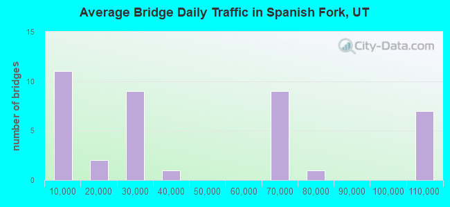
- 1,633,711Total average daily traffic
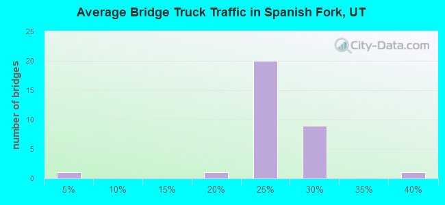
- 374,510Total average daily truck traffic
- National Bridge Inventory (NBI) Registered Bridges for Spanish Fork
- No street view available for this location
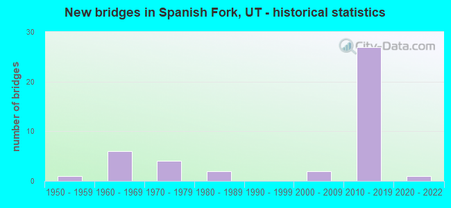
- New bridges - historical statistics
- 11950-1959
- 61960-1969
- 41970-1979
- 21980-1989
- 22000-2009
- 272010-2019
- 12020-2022
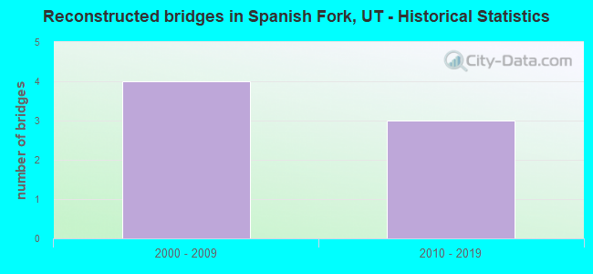
- Reconstructed bridges - Historical Statistics
- 42000-2009
- 32010-2019
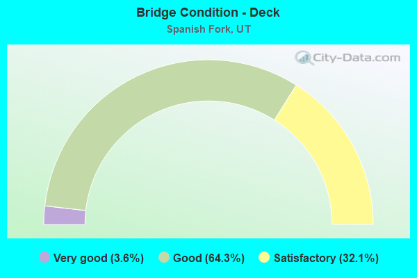
- Bridge Condition - Deck
- 3.6%Very good
- 64.3%Good
- 32.1%Satisfactory
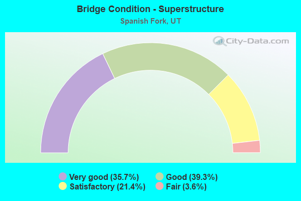
- Bridge Condition - Superstructure
- 35.7%Very good
- 39.3%Good
- 21.4%Satisfactory
- 3.6%Fair
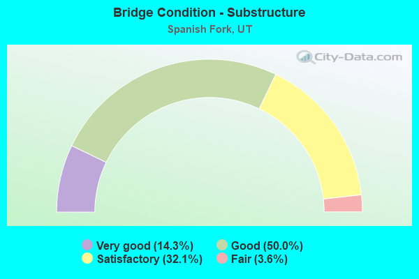
- Bridge Condition - Substructure
- 14.3%Very good
- 50.0%Good
- 32.1%Satisfactory
- 3.6%Fair
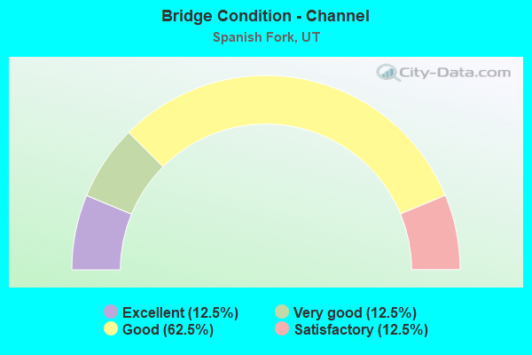
- Bridge Condition - Channel
- 12.5%Excellent
- 12.5%Very good
- 62.5%Good
- 12.5%Satisfactory
Find on map >> Show street view
Structure Number: 49029C, Location: EAST END CENTER ST.SP.FK. (Lat: 40.109811, Lng: -111.631583), Route carried "on" structure: City street 3062, Year Built: 1979, Year Reconstructed: 2016, Status: Open, Structure Length: 3.08m (10.10ft), Average Daily Traffic: 1,000 (year 2020), Average Future Daily Traffic: 1,250 (year 2040), Design Load: HL 93, Features Intersected: UNION PACIFIC RR, Facility Carried by Structure: CENTER STREET
Minimum Vertical Clearance: 30+ m (98+ ft), Kilometerpoint: 2.006, Lanes on structure: 5, Owner: City or Municipal Highway Agency, Approaching Roadway Width: 9.8m (32.2ft), Material/Design: Steel continuous, Design/Construction: Stringer/Multi-beam, Number Of Spans In Main Unit: 3, Length of Maximum Span: 12.8m (42.0ft), Curb or Sidewalk Widths: Left: 1.8m (5.9ft), Right: 0.0m, Curb-To-Curb Width: 9.8m (32.2ft), Out-to-Out Width: 21.6m (70.9ft)
Condition: Deck: Good, Superstructure: Good, Substructure: Good, Operating Rating: 44.7 metric tons, Method Used To Determine Operating Rating: Load and Resistance Factor Rating (LRFR) rating reported by rating factor(RF) method using HL-93 loadings, Inventory Rating: 37.3 metric tons, Method Used To Determine Inventory Rating: Load and Resistance Factor Rating (LRFR) rating reported by rating factor(RF) method using HL-93 loadings, Structural Evaluation: Better than present minimum criteria, Deck Geometry: High priority of replacement, Underclear: Equal to present minimum criteria, Approach Roadway Alignment: Equal to present minimum criteria, Designated Inspection Frequency: Every 24 months, Inspection Date: October 2021, Deck Structure Type: Concrete Cast-file-Place, Wearing Surface/Protective System: Wearing Surface: Monolithic Concrete
Find on map >> Show street view
Structure Number: 49041F, Location: 2000 E. 8400 S., SP. FK. (Lat: 40.080553, Lng: -111.604347), Route carried "on" structure: County highway 2866, Year Built: 1984, Status: Open, Structure Length: 1.26m (4.13ft), Average Daily Traffic: 168 (year 2020), Average Future Daily Traffic: 210 (year 2040), Design Load: HL 93, Features Intersected: HIGHLINE CANAL OVERFLOW, Facility Carried by Structure: POWER HOUSE ROAD
Minimum Vertical Clearance: 30+ m (98+ ft), Kilometerpoint: 5.359, Lanes on structure: 2, Owner: County Highway Agency, Approaching Roadway Width: 6.7m (22.0ft), Material/Design: Prestressed concrete, Design/Construction: Tee Beam, Number Of Spans In Main Unit: 1, Length of Maximum Span: 12.2m (40.0ft), Curb-To-Curb Width: 6.7m (22.0ft), Out-to-Out Width: 7.3m (24.0ft)
Condition: Deck: Satisfactory, Superstructure: Satisfactory, Substructure: Satisfactory, Channel: Good, Operating Rating: 32.4 metric tons, Method Used To Determine Operating Rating: Load and Resistance Factor Rating (LRFR) rating reported by rating factor(RF) method using HL-93 loadings, Inventory Rating: 21.1 metric tons, Method Used To Determine Inventory Rating: Load Factor (LF) rating reported by rating factor (RF) method using MS18 loading, Structural Evaluation: Equal to present minimum criteria, Deck Geometry: Meets minimum limits, Waterway Adequacy: Better than present minimum criteria, Approach Roadway Alignment: Better than present minimum criteria, Designated Inspection Frequency: Every 24 months, Inspection Date: October 2021, Deck Structure Type: Concrete Precast Panels, Wearing Surface/Protective System: Wearing Surface: Bituminous
Find on map >> Show street view
Structure Number: 49042D, Location: SE. SIDE OF SPANISH FORK (Lat: 40.084025, Lng: -111.597464), Route carried "on" structure: City street 2866, Year Built: 2002, Status: Open, Structure Length: 1.35m (4.43ft), Average Daily Traffic: 168 (year 2020), Average Future Daily Traffic: 210 (year 2040), Design Load: HS 20+Mod, Features Intersected: SPANISH FORK RIVER, Facility Carried by Structure: POWER HOUSE ROAD
Minimum Vertical Clearance: 30+ m (98+ ft), Kilometerpoint: 6.065, Lanes on structure: 3, Owner: City or Municipal Highway Agency, Approaching Roadway Width: 15.8m (51.8ft), Material/Design: Concrete, Design/Construction: Frame, Number Of Spans In Main Unit: 1, Length of Maximum Span: 12.8m (42.0ft), Curb or Sidewalk Widths: Left: 1.2m (3.9ft), Right: 0.0m, Curb-To-Curb Width: 15.8m (51.8ft), Out-to-Out Width: 23.3m (76.4ft)
Condition: Deck: Good, Superstructure: Good, Substructure: Very good, Channel: Good, Operating Rating: 41.5 metric tons, Method Used To Determine Operating Rating: Load and Resistance Factor Rating (LRFR) rating reported by rating factor(RF) method using HL-93 loadings, Inventory Rating: 21.7 metric tons, Method Used To Determine Inventory Rating: Load and Resistance Factor Rating (LRFR) rating reported by rating factor(RF) method using HL-93 loadings, Structural Evaluation: Equal to present minimum criteria, Deck Geometry: Better than present minimum criteria, Waterway Adequacy: Equal to present minimum criteria, Approach Roadway Alignment: Equal to present minimum criteria, Designated Inspection Frequency: Every 24 months, Inspection Date: October 2021, Wearing Surface/Protective System: Wearing Surface: Bituminous, Deck Protection: Epoxy Coated Reinforcing
Find on map >> Show street view
Structure Number: 49044F, Location: 9400 S.1100 E.,SW.SP.FORK (Lat: 40.075006, Lng: -111.629153), Route carried "on" structure: County highway , Year Built: 1985, Status: Open, Structure Length: 2.50m (8.20ft), Average Daily Traffic: 322 (year 2020), Truck Traffic: 4%, Average Future Daily Traffic: 392 (year 2040), Design Load: HS 20+Mod, Features Intersected: SPANISH FORK RIVER, Facility Carried by Structure: CO.RD.1100 EAST.ST
Minimum Vertical Clearance: 30.18m (99.02ft), Kilometerpoint: 0.122, Lanes on structure: 2, Owner: County Highway Agency, Approaching Roadway Width: 6.7m (22.0ft), Material/Design: Prestressed concrete, Design/Construction: Tee Beam, Number Of Spans In Main Unit: 1, Length of Maximum Span: 18.3m (60.0ft), Curb-To-Curb Width: 6.7m (22.0ft), Out-to-Out Width: 7.4m (24.3ft)
Condition: Deck: Satisfactory, Superstructure: Fair, Substructure: Satisfactory, Channel: Good, Operating Rating: 41.1 metric tons, Method Used To Determine Operating Rating: Load and Resistance Factor Rating (LRFR) rating reported by rating factor(RF) method using HL-93 loadings, Inventory Rating: 32.4 metric tons, Method Used To Determine Inventory Rating: Load Factor (LF) rating reported by rating factor (RF) method using MS18 loading, Structural Evaluation: Somewhat better than minimum adequacy, Deck Geometry: Meets minimum limits, Waterway Adequacy: Better than present minimum criteria, Approach Roadway Alignment: Equal to present desirable criteria, Designated Inspection Frequency: Every 24 months, Inspection Date: October 2021, Deck Structure Type: Concrete Precast Panels, Wearing Surface/Protective System: Wearing Surface: Bituminous
Find on map >> Show street view
Structure Number: 49097F, Location: 600 S. WEST PARK DRIVE (Lat: 40.099622, Lng: -111.669694), Route carried "on" structure: City street 2853, Year Built: 2010, Status: Open, Structure Length: 2.82m (9.25ft), Average Daily Traffic: 500 (year 2020), Average Future Daily Traffic: 625 (year 2040), Design Load: HS 20+Mod, Features Intersected: SPANISH FORK RIVER, Facility Carried by Structure: WEST PARK DRIVE
Minimum Vertical Clearance: 30+ m (98+ ft), Kilometerpoint: 1.026, Lanes on structure: 2, Owner: City or Municipal Highway Agency, Approaching Roadway Width: 11.9m (39.0ft), Material/Design: Prestressed concrete, Design/Construction: Stringer/Multi-beam, Number Of Spans In Main Unit: 1, Length of Maximum Span: 27.4m (89.9ft), Curb or Sidewalk Widths: Left: 1.5m (4.9ft), Right: 1.5m (4.9ft), Curb-To-Curb Width: 11.9m (39.0ft), Out-to-Out Width: 16.8m (55.1ft)
Condition: Deck: Satisfactory, Superstructure: Very good, Substructure: Good, Channel: Very good, Operating Rating: 50.2 metric tons, Method Used To Determine Operating Rating: Load and Resistance Factor Rating (LRFR) rating reported by rating factor(RF) method using HL-93 loadings, Inventory Rating: 36.0 metric tons, Method Used To Determine Inventory Rating: Load Factor (LF) rating reported by rating factor (RF) method using MS18 loading, Structural Evaluation: Better than present minimum criteria, Deck Geometry: Better than present minimum criteria, Waterway Adequacy: Equal to present desirable criteria, Approach Roadway Alignment: Equal to present desirable criteria, Designated Inspection Frequency: Every 24 months, Inspection Date: October 2021, Deck Structure Type: Concrete Cast-file-Place, Wearing Surface/Protective System: Wearing Surface: Monolithic Concrete, Deck Protection: Epoxy Coated Reinforcing
Find on map >> Show street view
Structure Number: C 679, Location: AT MOUTH SPANISH FK. CYN. (Lat: 40.082528, Lng: -111.589303), Route carried "on" structure: US 6, Year Built: 1978, Year Reconstructed: 2014, Status: Open, Structure Length: 7.17m (23.52ft), Average Daily Traffic: 12,495 (year 2020), Truck Traffic: 39%, Average Future Daily Traffic: 15,619 (year 2040), Design Load: HS 20+Mod, Features Intersected: UNION PACIFIC RAILROAD
Minimum Vertical Clearance: 30+ m (98+ ft), Kilometerpoint: 286.365, Lanes on structure: 2, Base Highway Network: Yes, Owner: State Highway Agency, Approaching Roadway Width: 17.1m (56.1ft), Skew: 4 degrees, Material/Design: Steel continuous, Design/Construction: Stringer/Multi-beam, Number Of Spans In Main Unit: 3, Length of Maximum Span: 33.7m (110.6ft), Curb-To-Curb Width: 17.1m (56.1ft), Out-to-Out Width: 17.9m (58.7ft)
Condition: Deck: Good, Superstructure: Good, Substructure: Satisfactory, Operating Rating: 45.7 metric tons, Method Used To Determine Operating Rating: Load and Resistance Factor Rating (LRFR) rating reported by rating factor(RF) method using HL-93 loadings, Inventory Rating: 36.6 metric tons, Method Used To Determine Inventory Rating: Load Factor (LF) rating reported by rating factor (RF) method using MS18 loading, Structural Evaluation: Equal to present minimum criteria, Deck Geometry: Superior to present desirable criteria, Underclear: Equal to present minimum criteria, Approach Roadway Alignment: Better than present minimum criteria, Designated Inspection Frequency: Every 24 months, Inspection Date: September 2020, Deck Structure Type: Concrete Precast Panels, Wearing Surface/Protective System: Wearing Surface: Epoxy Overlay, Deck Protection: Epoxy Coated Reinforcing
Find on map >> Show street view
Structure Number: D 609, Location: 1.6 MI W OF JCT SR-156 (Lat: 40.102614, Lng: -111.680597), Route carried "on" structure: State highway 115, Year Built: 1958, Status: Open, Structure Length: 1.77m (5.81ft), Average Daily Traffic: 1,249 (year 2020), Truck Traffic: 24%, Average Future Daily Traffic: 1,561 (year 2040), Design Load: H 15, Features Intersected: SPANISH FORK RIVER
Minimum Vertical Clearance: 30+ m (98+ ft), Kilometerpoint: 10.679, Lanes on structure: 2, Owner: State Highway Agency, Approaching Roadway Width: 8.5m (27.9ft), Skew: 1 degrees, Material/Design: Concrete, Design/Construction: Frame, Number Of Spans In Main Unit: 1, Length of Maximum Span: 15.8m (51.8ft), Curb or Sidewalk Widths: Left: 0.9m (3.0ft), Right: 0.9m (3.0ft), Curb-To-Curb Width: 8.5m (27.9ft), Out-to-Out Width: 10.4m (34.1ft)
Condition: Deck: Satisfactory, Superstructure: Satisfactory, Substructure: Good, Channel: Good, Operating Rating: 42.1 metric tons, Method Used To Determine Operating Rating: Load and Resistance Factor Rating (LRFR) rating reported by rating factor(RF) method using HL-93 loadings, Inventory Rating: 28.2 metric tons, Method Used To Determine Inventory Rating: Load and Resistance Factor Rating (LRFR) rating reported by rating factor(RF) method using HL-93 loadings, Structural Evaluation: Equal to present minimum criteria, Deck Geometry: Somewhat better than minimum adequacy, Waterway Adequacy: Better than present minimum criteria, Approach Roadway Alignment: Equal to present desirable criteria, Designated Inspection Frequency: Every 24 months, Inspection Date: September 2020, Deck Structure Type: Concrete Cast-file-Place, Wearing Surface/Protective System: Wearing Surface: Bituminous
Find on map >> Show street view
Structure Number: D 833, Location: MOUTH of SPANISH FORK CAN (Lat: 40.075356, Lng: -111.580547), Route carried "on" structure: US 6, Year Built: 2002, Status: Open, Structure Length: 1.40m (4.59ft), Average Daily Traffic: 12,037 (year 2020), Truck Traffic: 25%, Average Future Daily Traffic: 15,046 (year 2040), Design Load: HS 20+Mod, Features Intersected: UNION PACIFIC SPUR TRACK
Minimum Vertical Clearance: 30.18m (99.02ft), Kilometerpoint: 287.489, Lanes on structure: 2, Base Highway Network: Yes, Owner: State Highway Agency, Approaching Roadway Width: 12.1m (39.7ft), Skew: 5 degrees, Material/Design: Concrete, Design/Construction: Slab, Number Of Spans In Main Unit: 1, Length of Maximum Span: 7.0m (23.0ft), Curb-To-Curb Width: 25.7m (84.3ft), Out-to-Out Width: 26.4m (86.6ft)
Condition: Deck: Good, Superstructure: Good, Substructure: Satisfactory, Operating Rating: 35.3 metric tons, Method Used To Determine Operating Rating: Load and Resistance Factor Rating (LRFR) rating reported by rating factor(RF) method using HL-93 loadings, Inventory Rating: 16.2 metric tons, Method Used To Determine Inventory Rating: Load Factor (LF) rating reported by rating factor (RF) method using MS18 loading, Structural Evaluation: Meets minimum limits, Deck Geometry: Superior to present desirable criteria, Underclear: Meets minimum limits, Approach Roadway Alignment: Equal to present desirable criteria, Designated Inspection Frequency: Every 24 months, Inspection Date: September 2020, Deck Structure Type: Concrete Cast-file-Place, Wearing Surface/Protective System: Wearing Surface: Bituminous, Deck Protection: Epoxy Coated Reinforcing
Find on map >> Show street view
Structure Number: E2663, Location: 2.1Mi.SW of Spanish Fork (Lat: 40.103331, Lng: -111.683706), Route carried "on" structure: Interstate 15, Year Built: 2012, Status: Open, Structure Length: 1.40m (4.59ft), Average Daily Traffic: 60,929 (year 2020), Truck Traffic: 23%, Average Future Daily Traffic: 76,161 (year 2040), Design Load: HL 93, Features Intersected: SPANISH FORK RIVER
Minimum Vertical Clearance: 30+ m (98+ ft), Kilometerpoint: 411.150, Lanes on structure: 6, Base Highway Network: Yes, Owner: State Highway Agency, Approaching Roadway Width: 30.2m (99.1ft), Skew: 30 degrees, Material/Design: Concrete, Design/Construction: Culvert, Number Of Spans In Main Unit: 3, Length of Maximum Span: 4.3m (14.1ft), Curb-To-Curb Width: 32.9m (107.9ft), Out-to-Out Width: 63.4m (208.0ft)
Condition: Channel: Satisfactory, Culverts: Good, Operating Rating: 40.8 metric tons, Method Used To Determine Operating Rating: Load and Resistance Factor Rating (LRFR) rating reported by rating factor(RF) method using HL-93 loadings, Inventory Rating: 36.3 metric tons, Method Used To Determine Inventory Rating: Load and Resistance Factor Rating (LRFR) rating reported by rating factor(RF) method using HL-93 loadings, Structural Evaluation: Better than present minimum criteria, Deck Geometry: Superior to present desirable criteria, Waterway Adequacy: Better than present minimum criteria, Approach Roadway Alignment: Equal to present desirable criteria, Designated Inspection Frequency: Every 24 months, Inspection Date: September 2020
Find on map >> Show street view
Structure Number: F 263, Location: 4TH NO.ST.in SPANISH FORK (Lat: 40.115308, Lng: -111.635725), Route carried "on" structure: State highway 6, Year Built: 1971, Year Reconstructed: 2000, Status: Open, Structure Length: 3.16m (10.37ft), Average Daily Traffic: 30,166 (year 2020), Truck Traffic: 15%, Average Future Daily Traffic: 37,708 (year 2040), Design Load: HS 20+Mod, Features Intersected: SR-147
Minimum Vertical Clearance: 30.18m (99.02ft), Kilometerpoint: 280.823, Lanes on structure: 4, Lanes under structure: 2, Base Highway Network: Yes, Owner: State Highway Agency, Approaching Roadway Width: 20.0m (65.6ft), Skew: 1 degrees, Material/Design: Prestressed concrete, Design/Construction: Stringer/Multi-beam, Number Of Spans In Main Unit: 1, Length of Maximum Span: 30.2m (99.1ft), Curb-To-Curb Width: 19.1m (62.7ft), Out-to-Out Width: 20.7m (67.9ft)
Condition: Deck: Satisfactory, Superstructure: Satisfactory, Substructure: Fair, Operating Rating: 33.4 metric tons, Method Used To Determine Operating Rating: Load Factor (LF) rating reported by rating factor (RF) method using MS18 loading, Inventory Rating: 23.7 metric tons, Method Used To Determine Inventory Rating: Load Factor (LF) rating reported by rating factor (RF) method using MS18 loading, Structural Evaluation: Somewhat better than minimum adequacy, Deck Geometry: Equal to present minimum criteria, Underclear: Equal to present minimum criteria, Approach Roadway Alignment: Equal to present desirable criteria, Designated Inspection Frequency: Every 24 months, Inspection Date: September 2020, Deck Structure Type: Concrete Cast-file-Place, Wearing Surface/Protective System: Wearing Surface: Bituminous, Membrane: Preformed Fabric
Find on map >> Show street view
Structure Number: F 775, Location: South Spanish Fork (Lat: 40.094425, Lng: -111.655558), Route carried "on" structure: US 198, Year Built: 2010, Status: Open, Structure Length: 4.06m (13.32ft), Average Daily Traffic: 27,723 (year 2020), Truck Traffic: 21%, Average Future Daily Traffic: 34,654 (year 2040), Design Load: HL 93, Features Intersected: SPANISH FORK RIVER
Minimum Vertical Clearance: 30.18m (99.02ft), Kilometerpoint: 18.634, Lanes on structure: 4, Owner: State Highway Agency, Approaching Roadway Width: 25.6m (84.0ft), Skew: 2 degrees, Material/Design: Prestressed concrete, Design/Construction: Stringer/Multi-beam, Number Of Spans In Main Unit: 1, Length of Maximum Span: 39.6m (129.9ft), Curb or Sidewalk Widths: Left: 2.0m (6.6ft), Right: 0.0m, Curb-To-Curb Width: 25.6m (84.0ft), Out-to-Out Width: 28.4m (93.2ft)
Condition: Deck: Good, Superstructure: Good, Substructure: Good, Channel: Excellent, Operating Rating: 75.5 metric tons, Method Used To Determine Operating Rating: Load and Resistance Factor Rating (LRFR) rating reported by rating factor(RF) method using HL-93 loadings, Inventory Rating: 29.2 metric tons, Method Used To Determine Inventory Rating: Load and Resistance Factor Rating (LRFR) rating reported by rating factor(RF) method using HL-93 loadings, Structural Evaluation: Better than present minimum criteria, Deck Geometry: Superior to present desirable criteria, Waterway Adequacy: Equal to present desirable criteria, Approach Roadway Alignment: Equal to present desirable criteria, Designated Inspection Frequency: Every 24 months, Inspection Date: September 2020, Deck Structure Type: Concrete Precast Panels, Wearing Surface/Protective System: Wearing Surface: Epoxy Overlay, Deck Protection: Epoxy Coated Reinforcing
Find on map >> Show street view
Structure Number: F 83, Location: 1.5 Mi.No. of Sp.Fk. Int. (Lat: 40.144547, Lng: -111.647247), Route carried "on" structure: City street 2845, Year Built: 2010, Status: Open, Structure Length: 5.94m (19.49ft), Average Daily Traffic: 3,166 (year 2020), Average Future Daily Traffic: 3,958 (year 2040), Design Load: HL 93, Features Intersected: I-15, (SR-15), Facility Carried by Structure: 2700 N.ST.in SP.FK
Minimum Vertical Clearance: 30+ m (98+ ft), Kilometerpoint: 0.670, Lanes on structure: 2, Lanes under structure: 10, Owner: State Highway Agency, Approaching Roadway Width: 18.3m (60.0ft), Material/Design: Prestressed concrete continuous, Design/Construction: Stringer/Multi-beam, Number Of Spans In Main Unit: 2, Length of Maximum Span: 29.3m (96.1ft), Curb or Sidewalk Widths: Left: 3.0m (9.8ft), Right: 1.8m (5.9ft), Curb-To-Curb Width: 18.3m (60.0ft), Out-to-Out Width: 24.0m (78.7ft)
Condition: Deck: Good, Superstructure: Good, Substructure: Good, Operating Rating: 45.0 metric tons, Method Used To Determine Operating Rating: Load and Resistance Factor Rating (LRFR) rating reported by rating factor(RF) method using HL-93 loadings, Inventory Rating: 36.6 metric tons, Method Used To Determine Inventory Rating: Load and Resistance Factor Rating (LRFR) rating reported by rating factor(RF) method using HL-93 loadings, Structural Evaluation: Better than present minimum criteria, Deck Geometry: Superior to present desirable criteria, Underclear: Equal to present minimum criteria, Approach Roadway Alignment: Equal to present desirable criteria, Designated Inspection Frequency: Every 24 months, Inspection Date: September 2020, Deck Structure Type: Concrete Cast-file-Place, Wearing Surface/Protective System: Wearing Surface: Epoxy Overlay, Deck Protection: Epoxy Coated Reinforcing
Find on map >> Show street view
Structure Number: F 833, Location: US-6/Moark Con.Intchg. (Lat: 40.128139, Lng: -111.648600), Route carried "on" structure: US 15, Year Built: 2012, Status: Open, Structure Length: 7.99m (26.21ft), Average Daily Traffic: 23,546 (year 2020), Truck Traffic: 25%, Average Future Daily Traffic: 29,433 (year 2040), Design Load: HL 93, Features Intersected: I-15 (SR-15), Facility Carried by Structure: US-6, (SR-6)
Minimum Vertical Clearance: 30+ m (98+ ft), Kilometerpoint: 0.216, Lanes on structure: 5, Lanes under structure: 6, Base Highway Network: Yes (Inventory Route: 15NR2, Subroute: 12), Owner: State Highway Agency, Approaching Roadway Width: 25.6m (84.0ft), Skew: 3 degrees, Material/Design: Prestressed concrete continuous, Design/Construction: Stringer/Multi-beam, Number Of Spans In Main Unit: 2, Length of Maximum Span: 42.1m (138.1ft), Curb-To-Curb Width: 25.6m (84.0ft), Out-to-Out Width: 26.5m (86.9ft)
Condition: Deck: Good, Superstructure: Good, Substructure: Satisfactory, Operating Rating: 40.8 metric tons, Method Used To Determine Operating Rating: Load and Resistance Factor Rating (LRFR) rating reported by rating factor(RF) method using HL-93 loadings, Inventory Rating: 32.1 metric tons, Method Used To Determine Inventory Rating: Load and Resistance Factor Rating (LRFR) rating reported by rating factor(RF) method using HL-93 loadings, Structural Evaluation: Equal to present minimum criteria, Deck Geometry: Superior to present desirable criteria, Underclear: Equal to present minimum criteria, Approach Roadway Alignment: Equal to present desirable criteria, Designated Inspection Frequency: Every 24 months, Inspection Date: September 2020, Deck Structure Type: Concrete Cast-file-Place, Wearing Surface/Protective System: Wearing Surface: Epoxy Overlay, Deck Protection: Epoxy Coated Reinforcing
Find on map >> Show street view
Structure Number: 1C 999, Location: SP. FORK, MAIN ST. INTCHG (Lat: 40.124114, Lng: -111.655089), Route carried "on" structure: Interstate 15, Year Built: 2011, Status: Open, Structure Length: 5.69m (18.67ft), Average Daily Traffic: 23,546 (year 2020), Truck Traffic: 25%, Average Future Daily Traffic: 29,433 (year 2040), Design Load: HL 93, Features Intersected: SR-156, SP.FORK MAIN ST.
Minimum Vertical Clearance: 30+ m (98+ ft), Kilometerpoint: 0.281, Lanes on structure: 1, Lanes under structure: 6, Base Highway Network: Yes (Inventory Route: 15PR2, Subroute: 9), Owner: State Highway Agency, Approaching Roadway Width: 6.7m (22.0ft), Skew: 3 degrees, Material/Design: Steel, Design/Construction: Stringer/Multi-beam, Number Of Spans In Main Unit: 1, Length of Maximum Span: 55.9m (183.4ft), Curb-To-Curb Width: 8.5m (27.9ft), Out-to-Out Width: 9.4m (30.8ft)
Condition: Deck: Good, Superstructure: Very good, Substructure: Very good, Operating Rating: 54.8 metric tons, Method Used To Determine Operating Rating: Load and Resistance Factor Rating (LRFR) rating reported by rating factor(RF) method using HL-93 loadings, Inventory Rating: 35.6 metric tons, Method Used To Determine Inventory Rating: Load and Resistance Factor Rating (LRFR) rating reported by rating factor(RF) method using HL-93 loadings, Structural Evaluation: Equal to present desirable criteria, Deck Geometry: High priority of replacement, Underclear: Superior to present desirable criteria, Approach Roadway Alignment: Equal to present minimum criteria, Designated Inspection Frequency: Every 24 months, Inspection Date: September 2020, Deck Structure Type: Concrete Precast Panels, Wearing Surface/Protective System: Wearing Surface: Epoxy Overlay, Deck Protection: Epoxy Coated Reinforcing
Find on map >> Show street view
Structure Number: 1C1, Location: SPANISH FORK INTERCHG. (Lat: 40.124678, Lng: -111.655058), Route carried "on" structure: Interstate 15, Year Built: 2011, Status: Open, Structure Length: 5.00m (16.40ft), Average Daily Traffic: 60,929 (year 2020), Truck Traffic: 23%, Average Future Daily Traffic: 76,161 (year 2040), Design Load: HL 93, Features Intersected: SR-156, SP.FORK MAIN ST.
Minimum Vertical Clearance: 30+ m (98+ ft), Kilometerpoint: 414.557, Lanes on structure: 3, Lanes under structure: 7, Base Highway Network: Yes, Owner: State Highway Agency, Approaching Roadway Width: 18.1m (59.4ft), Skew: 33 degrees, Material/Design: Steel, Design/Construction: Stringer/Multi-beam, Number Of Spans In Main Unit: 1, Length of Maximum Span: 48.9m (160.4ft), Curb-To-Curb Width: 19.0m (62.3ft), Out-to-Out Width: 19.0m (62.3ft)
Condition: Deck: Good, Superstructure: Very good, Substructure: Good, Operating Rating: 57.0 metric tons, Method Used To Determine Operating Rating: Load and Resistance Factor Rating (LRFR) rating reported by rating factor(RF) method using HL-93 loadings, Inventory Rating: 40.2 metric tons, Method Used To Determine Inventory Rating: Load and Resistance Factor Rating (LRFR) rating reported by rating factor(RF) method using HL-93 loadings, Structural Evaluation: Better than present minimum criteria, Deck Geometry: Superior to present desirable criteria, Underclear: Superior to present desirable criteria, Approach Roadway Alignment: Equal to present desirable criteria, Designated Inspection Frequency: Every 24 months, Inspection Date: September 2020, Deck Structure Type: Concrete Precast Panels, Wearing Surface/Protective System: Wearing Surface: Epoxy Overlay, Deck Protection: Epoxy Coated Reinforcing
Find on map >> Show street view
Structure Number: 1F 103, Location: 1.7 MI.SW.SPANISH FK.INT. (Lat: 40.107878, Lng: -111.677750), Route carried "on" structure: Interstate 15, Year Built: 1967, Year Reconstructed: 2008, Status: Open, Structure Length: 4.21m (13.81ft), Average Daily Traffic: 60,929 (year 2020), Truck Traffic: 23%, Average Future Daily Traffic: 76,161 (year 2040), Design Load: HS 20+Mod, Features Intersected: LELAND SUGAR FACTORY RD.
Minimum Vertical Clearance: 30+ m (98+ ft), Kilometerpoint: 411.866, Lanes on structure: 3, Lanes under structure: 2, Base Highway Network: Yes, Owner: State Highway Agency, Approaching Roadway Width: 19.7m (64.6ft), Skew: 4 degrees, Material/Design: Prestressed concrete, Design/Construction: Stringer/Multi-beam, Number Of Spans In Main Unit: 3, Length of Maximum Span: 18.1m (59.4ft), Curb-To-Curb Width: 19.7m (64.6ft), Out-to-Out Width: 20.6m (67.6ft)
Condition: Deck: Satisfactory, Superstructure: Satisfactory, Substructure: Satisfactory, Operating Rating: 40.8 metric tons, Method Used To Determine Operating Rating: Load and Resistance Factor Rating (LRFR) rating reported by rating factor(RF) method using HL-93 loadings, Inventory Rating: 21.1 metric tons, Method Used To Determine Inventory Rating: Load Factor (LF) rating reported by rating factor (RF) method using MS18 loading, Structural Evaluation: Somewhat better than minimum adequacy, Deck Geometry: Superior to present desirable criteria, Underclear: Meets minimum limits, Approach Roadway Alignment: Equal to present desirable criteria, Designated Inspection Frequency: Every 24 months, Inspection Date: September 2020, Deck Structure Type: Concrete Precast Panels, Wearing Surface/Protective System: Wearing Surface: Epoxy Overlay
Find on map >> Show street view
Structure Number: 1F 104, Location: 1.5 MI SW SPANISH FK INT (Lat: 40.109664, Lng: -111.675347), Route carried "on" structure: Interstate 15, Year Built: 1967, Year Reconstructed: 2010, Status: Open, Structure Length: 5.64m (18.50ft), Average Daily Traffic: 60,929 (year 2020), Truck Traffic: 23%, Average Future Daily Traffic: 76,161 (year 2040), Design Load: HS 20+Mod, Features Intersected: UNION PACIFIC RAILROAD
Minimum Vertical Clearance: 30+ m (98+ ft), Kilometerpoint: 412.151, Lanes on structure: 3, Base Highway Network: Yes, Owner: State Highway Agency, Approaching Roadway Width: 19.6m (64.3ft), Skew: 4 degrees, Material/Design: Prestressed concrete, Design/Construction: Stringer/Multi-beam, Number Of Spans In Main Unit: 3, Length of Maximum Span: 18.3m (60.0ft), Curb-To-Curb Width: 19.6m (64.3ft), Out-to-Out Width: 20.5m (67.3ft)
Condition: Deck: Satisfactory, Superstructure: Good, Substructure: Satisfactory, Operating Rating: 40.2 metric tons, Method Used To Determine Operating Rating: Load and Resistance Factor Rating (LRFR) rating reported by rating factor(RF) method using HL-93 loadings, Inventory Rating: 24.6 metric tons, Method Used To Determine Inventory Rating: Load Factor (LF) rating reported by rating factor (RF) method using MS18 loading, Structural Evaluation: Equal to present minimum criteria, Deck Geometry: Superior to present desirable criteria, Underclear: Equal to present minimum criteria, Approach Roadway Alignment: Equal to present desirable criteria, Designated Inspection Frequency: Every 24 months, Inspection Date: September 2020, Deck Structure Type: Concrete Cast-file-Place, Wearing Surface/Protective System: Wearing Surface: Epoxy Overlay
Find on map >> Show street view
Structure Number: 1F 831, Location: 900 No.300 W. Spanish Fk. (Lat: 40.121444, Lng: -111.660150), Route carried "on" structure: Interstate 15, Year Built: 2012, Status: Open, Structure Length: 2.95m (9.68ft), Average Daily Traffic: 60,929 (year 2020), Truck Traffic: 23%, Average Future Daily Traffic: 76,161 (year 2040), Design Load: HL 93, Features Intersected: 300 WEST STREET
Minimum Vertical Clearance: 30+ m (98+ ft), Kilometerpoint: 413.993, Lanes on structure: 4, Lanes under structure: 2, Base Highway Network: Yes, Owner: State Highway Agency, Approaching Roadway Width: 25.1m (82.3ft), Skew: 3 degrees, Material/Design: Prestressed concrete, Design/Construction: Stringer/Multi-beam, Number Of Spans In Main Unit: 1, Length of Maximum Span: 28.3m (92.8ft), Curb-To-Curb Width: 25.1m (82.3ft), Out-to-Out Width: 26.0m (85.3ft)
Condition: Deck: Good, Superstructure: Good, Substructure: Good, Operating Rating: 55.4 metric tons, Method Used To Determine Operating Rating: Load and Resistance Factor Rating (LRFR) rating reported by rating factor(RF) method using HL-93 loadings, Inventory Rating: 36.9 metric tons, Method Used To Determine Inventory Rating: Load and Resistance Factor Rating (LRFR) rating reported by rating factor(RF) method using HL-93 loadings, Structural Evaluation: Better than present minimum criteria, Deck Geometry: Superior to present desirable criteria, Underclear: Meets minimum limits, Approach Roadway Alignment: Equal to present desirable criteria, Designated Inspection Frequency: Every 24 months, Inspection Date: September 2020, Deck Structure Type: Concrete Cast-file-Place, Wearing Surface/Protective System: Wearing Surface: Epoxy Overlay, Deck Protection: Epoxy Coated Reinforcing
Find on map >> Show street view
Structure Number: 1F 835, Location: 0.7Mi.No. of Spanish Fork (Lat: 40.132797, Lng: -111.646706), Route carried "on" structure: Interstate 15, Year Built: 2012, Status: Open, Structure Length: 3.80m (12.47ft), Average Daily Traffic: 101,934 (year 2020), Truck Traffic: 23%, Average Future Daily Traffic: 127,418 (year 2040), Design Load: HL 93, Features Intersected: UPRR and WILLIAMS LANE
Minimum Vertical Clearance: 30+ m (98+ ft), Kilometerpoint: 415.761, Lanes on structure: 5, Lanes under structure: 2, Base Highway Network: Yes, Owner: State Highway Agency, Approaching Roadway Width: 25.8m (84.6ft), Skew: 4 degrees, Material/Design: Prestressed concrete, Design/Construction: Stringer/Multi-beam, Number Of Spans In Main Unit: 1, Length of Maximum Span: 36.2m (118.8ft), Curb-To-Curb Width: 25.8m (84.6ft), Out-to-Out Width: 26.9m (88.3ft)
Condition: Deck: Good, Superstructure: Good, Substructure: Good, Operating Rating: 32.7 metric tons, Method Used To Determine Operating Rating: Load and Resistance Factor Rating (LRFR) rating reported by rating factor(RF) method using HL-93 loadings, Inventory Rating: 27.9 metric tons, Method Used To Determine Inventory Rating: Load and Resistance Factor Rating (LRFR) rating reported by rating factor(RF) method using HL-93 loadings, Structural Evaluation: Better than present minimum criteria, Deck Geometry: Equal to present desirable criteria, Underclear: Superior to present desirable criteria, Approach Roadway Alignment: Equal to present desirable criteria, Designated Inspection Frequency: Every 24 months, Inspection Date: September 2020, Deck Structure Type: Concrete Cast-file-Place, Wearing Surface/Protective System: Wearing Surface: Monolithic Concrete, Deck Protection: Epoxy Coated Reinforcing
Find on map >> Show street view
Structure Number: 1F 836, Location: 1.1 Mi.No. of US-6 Intchg (Lat: 40.137964, Lng: -111.646689), Route carried "on" structure: Interstate 15, Year Built: 2012, Status: Open, Structure Length: 3.13m (10.27ft), Average Daily Traffic: 101,934 (year 2020), Truck Traffic: 23%, Average Future Daily Traffic: 127,418 (year 2040), Design Load: HL 93, Features Intersected: UPRR SHARP SUB SPUR LINE
Minimum Vertical Clearance: 30+ m (98+ ft), Kilometerpoint: 416.335, Lanes on structure: 5, Base Highway Network: Yes, Owner: State Highway Agency, Approaching Roadway Width: 25.9m (85.0ft), Skew: 33 degrees, Material/Design: Prestressed concrete, Design/Construction: Stringer/Multi-beam, Number Of Spans In Main Unit: 1, Length of Maximum Span: 29.9m (98.1ft), Curb-To-Curb Width: 26.1m (85.6ft), Out-to-Out Width: 26.9m (88.3ft)
Condition: Deck: Good, Superstructure: Good, Substructure: Good, Operating Rating: 59.0 metric tons, Method Used To Determine Operating Rating: Load and Resistance Factor Rating (LRFR) rating reported by rating factor(RF) method using HL-93 loadings, Inventory Rating: 33.4 metric tons, Method Used To Determine Inventory Rating: Load and Resistance Factor Rating (LRFR) rating reported by rating factor(RF) method using HL-93 loadings, Structural Evaluation: Better than present minimum criteria, Deck Geometry: Superior to present desirable criteria, Underclear: Superior to present desirable criteria, Approach Roadway Alignment: Equal to present desirable criteria, Designated Inspection Frequency: Every 24 months, Inspection Date: September 2020, Deck Structure Type: Concrete Cast-file-Place, Wearing Surface/Protective System: Wearing Surface: Epoxy Overlay, Deck Protection: Epoxy Coated Reinforcing
Find on map >> Show street view
Structure Number: 3C1, Location: SPANISH FORK INTERCHG. (Lat: 40.125281, Lng: -111.654389), Route carried "on" structure: Interstate 15, Year Built: 2011, Status: Open, Structure Length: 5.00m (16.40ft), Average Daily Traffic: 60,929 (year 2020), Truck Traffic: 23%, Average Future Daily Traffic: 76,161 (year 2040), Design Load: HL 93, Features Intersected: SR-156, SP.FORK MAIN ST.
Minimum Vertical Clearance: 30+ m (98+ ft), Kilometerpoint: 414.466, Lanes on structure: 3, Lanes under structure: 7, Base Highway Network: Yes, Owner: State Highway Agency, Approaching Roadway Width: 18.1m (59.4ft), Skew: 33 degrees, Material/Design: Steel, Design/Construction: Stringer/Multi-beam, Number Of Spans In Main Unit: 1, Length of Maximum Span: 48.9m (160.4ft), Curb-To-Curb Width: 19.0m (62.3ft), Out-to-Out Width: 19.0m (62.3ft)
Condition: Deck: Good, Superstructure: Very good, Substructure: Good, Operating Rating: 57.0 metric tons, Method Used To Determine Operating Rating: Load and Resistance Factor Rating (LRFR) rating reported by rating factor(RF) method using HL-93 loadings, Inventory Rating: 40.2 metric tons, Method Used To Determine Inventory Rating: Load and Resistance Factor Rating (LRFR) rating reported by rating factor(RF) method using HL-93 loadings, Structural Evaluation: Better than present minimum criteria, Deck Geometry: Superior to present desirable criteria, Underclear: Superior to present desirable criteria, Approach Roadway Alignment: Equal to present desirable criteria, Designated Inspection Frequency: Every 24 months, Inspection Date: September 2020, Deck Structure Type: Concrete Precast Panels, Wearing Surface/Protective System: Wearing Surface: Epoxy Overlay, Deck Protection: Epoxy Coated Reinforcing
Find on map >> Show street view
Structure Number: 3C1001, Location: SPANISH FORK INTERCHG. (Lat: 40.125422, Lng: -111.654394), Route carried "on" structure: Ramp Interstate 15, Year Built: 2011, Status: Open, Structure Length: 5.00m (16.40ft), Average Daily Traffic: 23,546 (year 2020), Truck Traffic: 25%, Average Future Daily Traffic: 29,433 (year 2040), Design Load: HL 93, Features Intersected: SR-156, SP.FORK MAIN ST.
Minimum Vertical Clearance: 30+ m (98+ ft), Kilometerpoint: 0.913, Lanes on structure: 1, Lanes under structure: 7, Base Highway Network: Yes (Inventory Route: 15NR2, Subroute: 12), Owner: State Highway Agency, Approaching Roadway Width: 6.1m (20.0ft), Skew: 3 degrees, Material/Design: Steel, Design/Construction: Stringer/Multi-beam, Number Of Spans In Main Unit: 1, Length of Maximum Span: 48.9m (160.4ft), Curb-To-Curb Width: 8.5m (27.9ft), Out-to-Out Width: 9.4m (30.8ft)
Condition: Deck: Good, Superstructure: Very good, Substructure: Good, Operating Rating: 42.1 metric tons, Method Used To Determine Operating Rating: Load and Resistance Factor Rating (LRFR) rating reported by rating factor(RF) method using HL-93 loadings, Inventory Rating: 29.5 metric tons, Method Used To Determine Inventory Rating: Load and Resistance Factor Rating (LRFR) rating reported by rating factor(RF) method using HL-93 loadings, Structural Evaluation: Better than present minimum criteria, Deck Geometry: Superior to present desirable criteria, Underclear: Superior to present desirable criteria, Approach Roadway Alignment: Equal to present desirable criteria, Designated Inspection Frequency: Every 24 months, Inspection Date: September 2020, Deck Structure Type: Concrete Precast Panels, Wearing Surface/Protective System: Wearing Surface: Epoxy Overlay, Deck Protection: Epoxy Coated Reinforcing
Find on map >> Show street view
Structure Number: 3F 103, Location: 1.7 MI.SW.SPANISH FK.INT. (Lat: 40.108233, Lng: -111.677650), Route carried "on" structure: Interstate 15, Year Built: 1967, Year Reconstructed: 2010, Status: Open, Structure Length: 4.21m (13.81ft), Average Daily Traffic: 60,929 (year 2020), Truck Traffic: 23%, Average Future Daily Traffic: 76,161 (year 2040), Design Load: HS 20+Mod, Features Intersected: LELAND SUGAR FACTORY RD.
Minimum Vertical Clearance: 30+ m (98+ ft), Kilometerpoint: 411.720, Lanes on structure: 3, Lanes under structure: 2, Base Highway Network: Yes, Owner: State Highway Agency, Approaching Roadway Width: 19.7m (64.6ft), Skew: 34 degrees, Material/Design: Prestressed concrete, Design/Construction: Stringer/Multi-beam, Number Of Spans In Main Unit: 3, Length of Maximum Span: 18.1m (59.4ft), Curb-To-Curb Width: 19.7m (64.6ft), Out-to-Out Width: 20.6m (67.6ft)
Condition: Deck: Satisfactory, Superstructure: Satisfactory, Substructure: Satisfactory, Operating Rating: 40.8 metric tons, Method Used To Determine Operating Rating: Load and Resistance Factor Rating (LRFR) rating reported by rating factor(RF) method using HL-93 loadings, Inventory Rating: 24.6 metric tons, Method Used To Determine Inventory Rating: Load and Resistance Factor Rating (LRFR) rating reported by rating factor(RF) method using HL-93 loadings, Structural Evaluation: Equal to present minimum criteria, Deck Geometry: Superior to present desirable criteria, Underclear: Meets minimum limits, Approach Roadway Alignment: Equal to present desirable criteria, Designated Inspection Frequency: Every 24 months, Inspection Date: September 2020, Deck Structure Type: Concrete Cast-file-Place, Wearing Surface/Protective System: Wearing Surface: Epoxy Overlay
Find on map >> Show street view
Structure Number: 3F 104, Location: 1.5 MI.SW.SPANISH FK.INT. (Lat: 40.110122, Lng: -111.675119), Route carried "on" structure: Interstate 15, Year Built: 1967, Year Reconstructed: 2008, Status: Open, Structure Length: 5.64m (18.50ft), Average Daily Traffic: 60,929 (year 2020), Truck Traffic: 23%, Average Future Daily Traffic: 76,161 (year 2040), Design Load: HS 20+Mod, Features Intersected: UPRR, SPUR TRACK
Minimum Vertical Clearance: 30+ m (98+ ft), Kilometerpoint: 412.021, Lanes on structure: 3, Base Highway Network: Yes, Owner: State Highway Agency, Approaching Roadway Width: 19.7m (64.6ft), Skew: 4 degrees, Material/Design: Prestressed concrete, Design/Construction: Stringer/Multi-beam, Number Of Spans In Main Unit: 3, Length of Maximum Span: 18.3m (60.0ft), Curb-To-Curb Width: 19.7m (64.6ft), Out-to-Out Width: 20.6m (67.6ft)
Condition: Deck: Satisfactory, Superstructure: Satisfactory, Substructure: Satisfactory, Operating Rating: 40.2 metric tons, Method Used To Determine Operating Rating: Load and Resistance Factor Rating (LRFR) rating reported by rating factor(RF) method using HL-93 loadings, Inventory Rating: 24.6 metric tons, Method Used To Determine Inventory Rating: Load Factor (LF) rating reported by rating factor (RF) method using MS18 loading, Structural Evaluation: Equal to present minimum criteria, Deck Geometry: Superior to present desirable criteria, Underclear: Equal to present minimum criteria, Approach Roadway Alignment: Equal to present desirable criteria, Designated Inspection Frequency: Every 24 months, Inspection Date: September 2020, Deck Structure Type: Concrete Cast-file-Place, Wearing Surface/Protective System: Wearing Surface: Epoxy Overlay
Find on map >> Show street view
Structure Number: 3F 831, Location: 900 N.300 W.Spanish Fork (Lat: 40.121989, Lng: -111.659853), Route carried "on" structure: Interstate 15, Year Built: 2012, Status: Open, Structure Length: 2.95m (9.68ft), Average Daily Traffic: 60,929 (year 2020), Truck Traffic: 23%, Average Future Daily Traffic: 76,161 (year 2040), Design Load: HL 93, Features Intersected: 300 WEST STREET
Minimum Vertical Clearance: 30+ m (98+ ft), Kilometerpoint: 413.873, Lanes on structure: 5, Lanes under structure: 2, Base Highway Network: Yes, Owner: State Highway Agency, Approaching Roadway Width: 24.8m (81.4ft), Skew: 3 degrees, Material/Design: Prestressed concrete, Design/Construction: Stringer/Multi-beam, Number Of Spans In Main Unit: 1, Length of Maximum Span: 28.3m (92.8ft), Curb-To-Curb Width: 24.8m (81.4ft), Out-to-Out Width: 25.7m (84.3ft)
Condition: Deck: Good, Superstructure: Very good, Substructure: Good, Operating Rating: 43.4 metric tons, Method Used To Determine Operating Rating: Load and Resistance Factor Rating (LRFR) rating reported by rating factor(RF) method using HL-93 loadings, Inventory Rating: 39.5 metric tons, Method Used To Determine Inventory Rating: Load and Resistance Factor Rating (LRFR) rating reported by rating factor(RF) method using HL-93 loadings, Structural Evaluation: Better than present minimum criteria, Deck Geometry: Better than present minimum criteria, Underclear: Meets minimum limits, Approach Roadway Alignment: Equal to present desirable criteria, Designated Inspection Frequency: Every 24 months, Inspection Date: September 2020, Deck Structure Type: Concrete Cast-file-Place, Wearing Surface/Protective System: Wearing Surface: Epoxy Overlay, Deck Protection: Epoxy Coated Reinforcing
Find on map >> Show street view
Structure Number: 3F 834, Location: At US-6, Moark Interchg. (Lat: 40.132750, Lng: -111.647342), Route carried "on" structure: Ramp Interstate 15, Year Built: 2012, Status: Open, Structure Length: 4.05m (13.29ft), Average Daily Traffic: 23,546 (year 2020), Truck Traffic: 25%, Average Future Daily Traffic: 29,433 (year 2040), Design Load: HL 93, Features Intersected: UPRR AND WILLIAMS LANE
Minimum Vertical Clearance: 30+ m (98+ ft), Kilometerpoint: 0.523, Lanes on structure: 3, Lanes under structure: 2, Base Highway Network: Yes (Inventory Route: 15NR2, Subroute: 3), Owner: State Highway Agency, Approaching Roadway Width: 15.8m (51.8ft), Skew: 5 degrees, Material/Design: Prestressed concrete, Design/Construction: Stringer/Multi-beam, Number Of Spans In Main Unit: 1, Length of Maximum Span: 38.3m (125.7ft), Curb-To-Curb Width: 15.8m (51.8ft), Out-to-Out Width: 16.7m (54.8ft)
Condition: Deck: Good, Superstructure: Very good, Substructure: Very good, Operating Rating: 66.7 metric tons, Method Used To Determine Operating Rating: Load and Resistance Factor Rating (LRFR) rating reported by rating factor(RF) method using HL-93 loadings, Inventory Rating: 30.8 metric tons, Method Used To Determine Inventory Rating: Load and Resistance Factor Rating (LRFR) rating reported by rating factor(RF) method using HL-93 loadings, Structural Evaluation: Better than present minimum criteria, Deck Geometry: Superior to present desirable criteria, Underclear: Superior to present desirable criteria, Approach Roadway Alignment: Equal to present desirable criteria, Designated Inspection Frequency: Every 24 months, Inspection Date: September 2020, Deck Structure Type: Concrete Cast-file-Place, Wearing Surface/Protective System: Wearing Surface: Epoxy Overlay, Deck Protection: Epoxy Coated Reinforcing
Find on map >> Show street view
Structure Number: 3F 835, Location: 0.7Mi.No.of Spanish Fork (Lat: 40.133028, Lng: -111.646975), Route carried "on" structure: Interstate 15, Year Built: 2012, Status: Open, Structure Length: 3.80m (12.47ft), Average Daily Traffic: 101,934 (year 2020), Truck Traffic: 23%, Average Future Daily Traffic: 127,418 (year 2040), Design Load: HL 93, Features Intersected: UPRR & WILLIAMS LN.
Minimum Vertical Clearance: 30+ m (98+ ft), Kilometerpoint: 415.592, Lanes on structure: 3, Lanes under structure: 2, Base Highway Network: Yes, Owner: State Highway Agency, Approaching Roadway Width: 18.5m (60.7ft), Skew: 4 degrees, Material/Design: Prestressed concrete, Design/Construction: Stringer/Multi-beam, Number Of Spans In Main Unit: 1, Length of Maximum Span: 36.2m (118.8ft), Curb-To-Curb Width: 18.5m (60.7ft), Out-to-Out Width: 19.0m (62.3ft)
Condition: Deck: Good, Superstructure: Very good, Substructure: Good, Operating Rating: 61.2 metric tons, Method Used To Determine Operating Rating: Load and Resistance Factor Rating (LRFR) rating reported by rating factor(RF) method using HL-93 loadings, Inventory Rating: 28.8 metric tons, Method Used To Determine Inventory Rating: Load and Resistance Factor Rating (LRFR) rating reported by rating factor(RF) method using HL-93 loadings, Structural Evaluation: Better than present minimum criteria, Deck Geometry: Superior to present desirable criteria, Underclear: Superior to present desirable criteria, Approach Roadway Alignment: Equal to present desirable criteria, Designated Inspection Frequency: Every 24 months, Inspection Date: September 2020, Deck Structure Type: Concrete Cast-file-Place, Wearing Surface/Protective System: Wearing Surface: Epoxy Overlay, Deck Protection: Epoxy Coated Reinforcing
Find on map >> Show street view
Structure Number: 3F 836, Location: 1.1 Mi.No.of US-6 Intchg. (Lat: 40.138222, Lng: -111.646967), Route carried "on" structure: Interstate 15, Year Built: 2012, Status: Open, Structure Length: 3.13m (10.27ft), Average Daily Traffic: 101,934 (year 2020), Truck Traffic: 23%, Average Future Daily Traffic: 127,418 (year 2040), Design Load: HL 93, Features Intersected: UPRR SHARP SUB SPUR LINE
Minimum Vertical Clearance: 30+ m (98+ ft), Kilometerpoint: 416.169, Lanes on structure: 5, Base Highway Network: Yes, Owner: State Highway Agency, Approaching Roadway Width: 25.9m (85.0ft), Skew: 3 degrees, Material/Design: Prestressed concrete, Design/Construction: Stringer/Multi-beam, Number Of Spans In Main Unit: 1, Length of Maximum Span: 29.9m (98.1ft), Curb-To-Curb Width: 26.1m (85.6ft), Out-to-Out Width: 26.9m (88.3ft)
Condition: Deck: Good, Superstructure: Very good, Substructure: Good, Operating Rating: 59.0 metric tons, Method Used To Determine Operating Rating: Load and Resistance Factor Rating (LRFR) rating reported by rating factor(RF) method using HL-93 loadings, Inventory Rating: 33.4 metric tons, Method Used To Determine Inventory Rating: Load and Resistance Factor Rating (LRFR) rating reported by rating factor(RF) method using HL-93 loadings, Structural Evaluation: Better than present minimum criteria, Deck Geometry: Superior to present desirable criteria, Underclear: Superior to present desirable criteria, Approach Roadway Alignment: Equal to present desirable criteria, Designated Inspection Frequency: Every 24 months, Inspection Date: September 2020, Deck Structure Type: Concrete Cast-file-Place, Wearing Surface/Protective System: Wearing Surface: Epoxy Overlay, Deck Protection: Epoxy Coated Reinforcing
Find on map >> Show street view
Structure Number: 47079F, Location: 2 MILES SOUTH OF OURAY (Lat: 40.064164, Lng: -111.567389), Route carried "on" structure: County highway 2765, Year Built: 2020, Status: Open, Structure Length: 4.02m (13.19ft), Average Daily Traffic: 63 (year 2020), Average Future Daily Traffic: 79 (year 2040), Design Load: HL 93, Features Intersected: WHITE RIVER, Facility Carried by Structure: SEEP RIDGE RD
Minimum Vertical Clearance: 30.45m (99.90ft), Kilometerpoint: 83.831, Lanes on structure: 2, Owner: County Highway Agency, Approaching Roadway Width: 13.4m (44.0ft), Material/Design: Prestressed concrete, Design/Construction: Stringer/Multi-beam, Number Of Spans In Main Unit: 1, Length of Maximum Span: 39.0m (128.0ft), Curb-To-Curb Width: 13.4m (44.0ft), Out-to-Out Width: 14.3m (46.9ft)
Condition: Deck: Very good, Superstructure: Very good, Substructure: Very good, Channel: Good, Operating Rating: 73.9 metric tons, Method Used To Determine Operating Rating: Load and Resistance Factor Rating (LRFR) rating reported by rating factor(RF) method using HL-93 loadings, Inventory Rating: 40.5 metric tons, Method Used To Determine Inventory Rating: Load and Resistance Factor Rating (LRFR) rating reported by rating factor(RF) method using HL-93 loadings, Structural Evaluation: Equal to present desirable criteria, Deck Geometry: Superior to present desirable criteria, Waterway Adequacy: Equal to present desirable criteria, Approach Roadway Alignment: Equal to present desirable criteria, Designated Inspection Frequency: Every 24 months, Inspection Date: July 2020, Deck Structure Type: Concrete Cast-file-Place, Wearing Surface/Protective System: Wearing Surface: Epoxy Overlay, Deck Protection: Epoxy Coated Reinforcing
Find on map >> Show street view
Structure Number: F 263, Location: 4TH NO.ST.in SPANISH FORK (Lat: 40.115308, Lng: -111.635725), Route carried "under" structure: State highway 147, Year Built: 1971, Structure Length: 0. m, Average Daily Traffic: 2,742 (year 2020), Truck Traffic: 20%, Features Intersected: SR-147, Facility Carried by Structure: US-6 (SR-6)
Minimum Vertical Clearance: 4.62m (15.16ft), Kilometerpoint: 25.824, Lanes on structure: 4, Lanes under structure: 2, Material/Design: Prestressed concrete, Design/Construction: Stringer/Multi-beam, Length of Maximum Span: 30.2m (99.1ft)
Find on map >> Show street view
Structure Number: F 83, Location: 1.5 Mi.No. of Sp.Fk. Int. (Lat: 40.144547, Lng: -111.647247), Route carried "under" structure: Interstate 15, Year Built: 2010, Structure Length: 0. m, Average Daily Traffic: 101,934 (year 2020), Truck Traffic: 23%, Features Intersected: I-15, (SR-15), Facility Carried by Structure: 2700 N.ST.in SP.FK
Minimum Vertical Clearance: 5.06m (16.60ft), Kilometerpoint: 416.526, Lanes on structure: 2, Lanes under structure: 10, Material/Design: Prestressed concrete continuous, Design/Construction: Stringer/Multi-beam, Length of Maximum Span: 29.3m (96.1ft)
Find on map >> Show street view
Structure Number: F 833, Location: US-6/Moark Con.Intchg. (Lat: 40.128139, Lng: -111.648600), Route carried "under" structure: Interstate 15, Year Built: 2012, Structure Length: 0. m, Average Daily Traffic: 76,067 (year 2020), Truck Traffic: 23%, Features Intersected: I-15 (SR-15), Facility Carried by Structure: US-6, (SR-6)
Minimum Vertical Clearance: 5.05m (16.57ft), Kilometerpoint: 414.625, Lanes on structure: 5, Lanes under structure: 6, Material/Design: Prestressed concrete continuous, Design/Construction: Stringer/Multi-beam, Length of Maximum Span: 42.1m (138.1ft)
Find on map >> Show street view
Structure Number: 1C 999, Location: SP. FORK, MAIN ST. INTCHG (Lat: 40.124114, Lng: -111.655089), Route carried "under" structure: State highway 156, Year Built: 2011, Structure Length: 0. m, Average Daily Traffic: 26,316 (year 2020), Truck Traffic: 26%, Features Intersected: SR-156, SP.FORK MAIN ST., Facility Carried by Structure: I-15 NB RP.to SR-6
Minimum Vertical Clearance: 5.11m (16.77ft), Kilometerpoint: 2.108, Lanes on structure: 1, Lanes under structure: 6, Material/Design: Steel, Design/Construction: Stringer/Multi-beam, Length of Maximum Span: 55.9m (183.4ft)
Find on map >> Show street view
Structure Number: 1C1, Location: SPANISH FORK INTERCHG. (Lat: 40.124678, Lng: -111.655058), Route carried "under" structure: State highway 156, Year Built: 2011, Structure Length: 0. m, Average Daily Traffic: 26,316 (year 2020), Truck Traffic: 26%, Features Intersected: SR-156, SP.FORK MAIN ST., Facility Carried by Structure: I-15 (SR-15) NBL
Minimum Vertical Clearance: 5.21m (17.09ft), Kilometerpoint: 2.108, Lanes on structure: 3, Lanes under structure: 7, Material/Design: Steel, Design/Construction: Stringer/Multi-beam, Length of Maximum Span: 48.9m (160.4ft)
Find on map >> Show street view
Structure Number: 1F 103, Location: 1.7 MI.SW.SPANISH FK.INT. (Lat: 40.107878, Lng: -111.677750), Route carried "under" structure: County highway , Year Built: 1967, Structure Length: 0. m, Features Intersected: LELAND SUGAR FACTORY RD., Facility Carried by Structure: I-15 (SR-15) NBL
Minimum Vertical Clearance: 4.93m (16.17ft), Kilometerpoint: 0.000, Lanes on structure: 3, Lanes under structure: 2, Material/Design: Prestressed concrete, Design/Construction: Stringer/Multi-beam, Length of Maximum Span: 18.1m (59.4ft)
Find on map >> Show street view
Structure Number: 1F 831, Location: 900 No.300 W. Spanish Fk. (Lat: 40.121444, Lng: -111.660150), Route carried "under" structure: City street 2831, Year Built: 2012, Structure Length: 0. m, Average Daily Traffic: 183 (year 2020), Features Intersected: 300 WEST STREET, Facility Carried by Structure: I-15NB, (SR-15)
Minimum Vertical Clearance: 5.03m (16.50ft), Kilometerpoint: 0.000, Lanes on structure: 4, Lanes under structure: 2, Material/Design: Prestressed concrete, Design/Construction: Stringer/Multi-beam, Length of Maximum Span: 28.3m (92.8ft)
Find on map >> Show street view
Structure Number: 1F 835, Location: 0.7Mi.No. of Spanish Fork (Lat: 40.132797, Lng: -111.646706), Route carried "under" structure: ServiceCity street , Year Built: 2012, Structure Length: 0. m, Average Daily Traffic: 104,000 (year 2020), Truck Traffic: 21%, Features Intersected: UPRR and WILLIAMS LANE, Facility Carried by Structure: I-15NB, (SR-15)
Minimum Vertical Clearance: 7.36m (24.15ft), Kilometerpoint: 0.000, Lanes on structure: 5, Lanes under structure: 2, Material/Design: Prestressed concrete, Design/Construction: Stringer/Multi-beam, Length of Maximum Span: 36.2m (118.8ft)
Find on map >> Show street view
Structure Number: 3C1, Location: SPANISH FORK INTERCHG. (Lat: 40.125281, Lng: -111.654389), Route carried "under" structure: State highway 156, Year Built: 2011, Structure Length: 0. m, Average Daily Traffic: 26,316 (year 2020), Truck Traffic: 26%, Features Intersected: SR-156, SP.FORK MAIN ST., Facility Carried by Structure: I-15 (SR-15) SBL
Minimum Vertical Clearance: 5.13m (16.83ft), Kilometerpoint: 2.108, Lanes on structure: 3, Lanes under structure: 7, Material/Design: Steel, Design/Construction: Stringer/Multi-beam, Length of Maximum Span: 48.9m (160.4ft)
Find on map >> Show street view
Structure Number: 3C1001, Location: SPANISH FORK INTERCHG. (Lat: 40.125422, Lng: -111.654394), Route carried "under" structure: State highway 156, Year Built: 2011, Structure Length: 0. m, Average Daily Traffic: 26,316 (year 2020), Truck Traffic: 26%, Features Intersected: SR-156, SP.FORK MAIN ST., Facility Carried by Structure: I-15 SB RP.fr.SR-6
Minimum Vertical Clearance: 5.11m (16.77ft), Kilometerpoint: 2.108, Lanes on structure: 1, Lanes under structure: 7, Material/Design: Steel, Design/Construction: Stringer/Multi-beam, Length of Maximum Span: 48.9m (160.4ft)
Find on map >> Show street view
Structure Number: 3F 103, Location: 1.7 MI.SW.SPANISH FK.INT. (Lat: 40.108233, Lng: -111.677650), Route carried "under" structure: County highway , Year Built: 1967, Structure Length: 0. m, Features Intersected: LELAND SUGAR FACTORY RD., Facility Carried by Structure: I-15 (SR-15) SBL
Minimum Vertical Clearance: 4.85m (15.91ft), Kilometerpoint: 0.000, Lanes on structure: 3, Lanes under structure: 2, Material/Design: Prestressed concrete, Design/Construction: Stringer/Multi-beam, Length of Maximum Span: 18.1m (59.4ft)
Find on map >> Show street view
Structure Number: 3F 831, Location: 900 N.300 W.Spanish Fork (Lat: 40.121989, Lng: -111.659853), Route carried "under" structure: City street 2831, Year Built: 2012, Structure Length: 0. m, Average Daily Traffic: 183 (year 2020), Features Intersected: 300 WEST STREET, Facility Carried by Structure: I-15SB, (SR-15)
Minimum Vertical Clearance: 5.59m (18.34ft), Kilometerpoint: 0.000, Lanes on structure: 5, Lanes under structure: 2, Material/Design: Prestressed concrete, Design/Construction: Stringer/Multi-beam, Length of Maximum Span: 28.3m (92.8ft)
Find on map >> Show street view
Structure Number: 3F 834, Location: At US-6, Moark Interchg. (Lat: 40.132750, Lng: -111.647342), Route carried "under" structure: ServiceCity street , Year Built: 2012, Structure Length: 0. m, Features Intersected: UPRR AND WILLIAMS LANE, Facility Carried by Structure: I-15SB OFF-RP.-US6
Minimum Vertical Clearance: 7.17m (23.52ft), Kilometerpoint: 0.000, Lanes on structure: 3, Lanes under structure: 2, Material/Design: Prestressed concrete, Design/Construction: Stringer/Multi-beam, Length of Maximum Span: 38.3m (125.7ft)
Find on map >> Show street view
Structure Number: 3F 835, Location: 0.7Mi.No.of Spanish Fork (Lat: 40.133028, Lng: -111.646975), Route carried "under" structure: ServiceCity street , Year Built: 2012, Structure Length: 0. m, Average Daily Traffic: 104,000 (year 2020), Truck Traffic: 21%, Features Intersected: UPRR & WILLIAMS LN., Facility Carried by Structure: I-15SB, (SR-15)
Minimum Vertical Clearance: 7.36m (24.15ft), Kilometerpoint: 0.000, Lanes on structure: 3, Lanes under structure: 2, Material/Design: Prestressed concrete, Design/Construction: Stringer/Multi-beam, Length of Maximum Span: 36.2m (118.8ft)