Bridge Statistics for Southgate, Michigan (MI)
Condition, Traffic, Stress, Structural Evaluation, Project Costs
- National Bridge Inventory (NBI) Statistics
- 15Number of bridges
- 125ft / 38.4mTotal length
- 421,991Total average daily traffic
- 59,928Total average daily truck traffic
- National Bridge Inventory (NBI) Registered Bridges for Southgate
- No street view available for this location
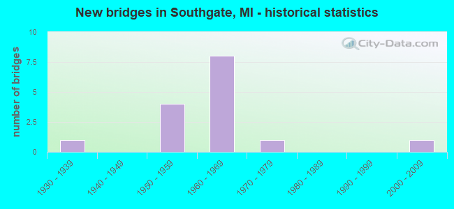
- New bridges - historical statistics
- 11930-1939
- 41950-1959
- 81960-1969
- 11970-1979
- 12000-2009


- Bridge Condition - Deck
- 14.3%Excellent
- 42.9%Very good
- 42.9%Satisfactory

- Bridge Condition - Superstructure
- 85.7%Good
- 14.3%Satisfactory

- Bridge Condition - Substructure
- 28.6%Very good
- 57.1%Good
- 14.3%Satisfactory
Find on map >> Show street view
Structure Number: 1166, Location: GIRARD TWP SEC 24 (Lat: 42.022483, Lng: -84.956908), Route carried "on" structure: County highway , Year Built: 2001, Status: Open, Structure Length: 2.04m (6.69ft), Average Daily Traffic: 40 (year 2004), Average Future Daily Traffic: 81 (year 2024), Design Load: HS 20, Features Intersected: SOUTH BR HOG CREEK, Facility Carried by Structure: GORBELL ROAD
Minimum Vertical Clearance: 30.48m (100.00ft), Kilometerpoint: 4.489, Lanes on structure: 2, Owner: County Highway Agency, Approaching Roadway Width: 6.1m (20.0ft), Skew: 5 degrees, Material/Design: Prestressed concrete, Design/Construction: Box Beam or Girders - Multiple, Number Of Spans In Main Unit: 1, Length of Maximum Span: 19.2m (63.0ft), Curb-To-Curb Width: 9.4m (30.8ft), Out-to-Out Width: 9.5m (31.2ft)
Condition: Deck: Satisfactory, Superstructure: Satisfactory, Substructure: Good, Channel: Good, Operating Rating: 56.8 metric tons, Method Used To Determine Operating Rating: Load Factor (LF), Inventory Rating: 34.0 metric tons, Method Used To Determine Inventory Rating: Load Factor (LF), Structural Evaluation: Equal to present minimum criteria, Waterway Adequacy: Equal to present desirable criteria, Approach Roadway Alignment: Equal to present desirable criteria, Designated Inspection Frequency: Every 24 months, Inspection Date: October 2020, Wearing Surface/Protective System: Wearing Surface: Bituminous, Membrane: Preformed Fabric, Deck Protection: Bituminous
Find on map >> Show street view
Structure Number: 11658, Location: S LTS OF SOUTHGATE (Lat: 42.207897, Lng: -83.228989), Route carried "on" structure: Interstate 75, Year Built: 1966, Status: Open, Structure Length: 6.65m (21.82ft), Average Daily Traffic: 46,853 (year 2015), Truck Traffic: 20%, Average Future Daily Traffic: 52,548 (year 2038), Design Load: HS 20+Mod, Features Intersected: ALLEN RD
Minimum Vertical Clearance: 30.48m (100.00ft), Kilometerpoint: 16.152, Lanes on structure: 3, Lanes under structure: 4, Base Highway Network: Yes (Inventory Route: 159, Subroute: 10), Owner: State Highway Agency, Approaching Roadway Width: 16.4m (53.8ft), Skew: 4 degrees, Material/Design: Steel continuous, Design/Construction: Stringer/Multi-beam, Number Of Spans In Main Unit: 4, Length of Maximum Span: 18.9m (62.0ft), Curb-To-Curb Width: 15.7m (51.5ft), Out-to-Out Width: 16.6m (54.5ft)
Condition: Deck: Satisfactory, Superstructure: Good, Substructure: Good, Operating Rating: 52.5 metric tons, Method Used To Determine Operating Rating: Load Factor (LF) rating reported by rating factor (RF) method using MS18 loading, Inventory Rating: 31.4 metric tons, Method Used To Determine Inventory Rating: Load Factor (LF) rating reported by rating factor (RF) method using MS18 loading, Structural Evaluation: Better than present minimum criteria, Deck Geometry: Somewhat better than minimum adequacy, Underclear: Meets minimum limits, Approach Roadway Alignment: Equal to present desirable criteria, Designated Inspection Frequency: Every 24 months, Inspection Date: July 2021, Deck Structure Type: Concrete Cast-file-Place, Wearing Surface/Protective System: Wearing Surface: Epoxy Overlay
Find on map >> Show street view
Structure Number: 11659, Location: S LTS OF SOUTHGATE (Lat: 42.208256, Lng: -83.229006), Route carried "on" structure: Interstate 75, Year Built: 1966, Status: Open, Structure Length: 6.65m (21.82ft), Average Daily Traffic: 46,853 (year 2015), Truck Traffic: 20%, Average Future Daily Traffic: 52,548 (year 2038), Design Load: HS 20+Mod, Features Intersected: ALLEN RD
Minimum Vertical Clearance: 30.48m (100.00ft), Kilometerpoint: 16.189, Lanes on structure: 3, Lanes under structure: 4, Base Highway Network: Yes (Inventory Route: 159, Subroute: 6), Owner: State Highway Agency, Approaching Roadway Width: 15.7m (51.5ft), Skew: 4 degrees, Material/Design: Steel continuous, Design/Construction: Stringer/Multi-beam, Number Of Spans In Main Unit: 4, Length of Maximum Span: 18.9m (62.0ft), Curb-To-Curb Width: 15.7m (51.5ft), Out-to-Out Width: 16.6m (54.5ft)
Condition: Deck: Satisfactory, Superstructure: Good, Substructure: Satisfactory, Operating Rating: 52.5 metric tons, Method Used To Determine Operating Rating: Load Factor (LF) rating reported by rating factor (RF) method using MS18 loading, Inventory Rating: 31.4 metric tons, Method Used To Determine Inventory Rating: Load Factor (LF) rating reported by rating factor (RF) method using MS18 loading, Structural Evaluation: Equal to present minimum criteria, Deck Geometry: Somewhat better than minimum adequacy, Underclear: High priority of corrective action, Approach Roadway Alignment: Equal to present desirable criteria, Designated Inspection Frequency: Every 24 months, Inspection Date: September 2020, Deck Structure Type: Concrete Cast-file-Place, Wearing Surface/Protective System: Wearing Surface: Epoxy Overlay
Find on map >> Show street view
Structure Number: 1166, Location: IN SOUTHGATE (Lat: 42.213222, Lng: -83.222075), Route carried "on" structure: Interstate 75, Year Built: 1966, Year Reconstructed: 2019, Status: Open, Structure Length: 6.31m (20.70ft), Average Daily Traffic: 46,853 (year 2015), Truck Traffic: 20%, Average Future Daily Traffic: 52,548 (year 2038), Design Load: HS 20+Mod, Features Intersected: NORTH LINE RD
Minimum Vertical Clearance: 30.48m (100.00ft), Kilometerpoint: 16.974, Lanes on structure: 3, Lanes under structure: 4, Base Highway Network: Yes (Inventory Route: 159, Subroute: 10), Owner: State Highway Agency, Approaching Roadway Width: 18.3m (60.0ft), Skew: 4 degrees, Material/Design: Steel continuous, Design/Construction: Stringer/Multi-beam, Number Of Spans In Main Unit: 4, Length of Maximum Span: 18.3m (60.0ft), Curb-To-Curb Width: 18.3m (60.0ft), Out-to-Out Width: 19.3m (63.3ft)
Condition: Deck: Very good, Superstructure: Good, Substructure: Very good, Operating Rating: 71.6 metric tons, Method Used To Determine Operating Rating: Load Factor (LF) rating reported by rating factor (RF) method using MS18 loading, Inventory Rating: 42.8 metric tons, Method Used To Determine Inventory Rating: Load Factor (LF) rating reported by rating factor (RF) method using MS18 loading, Structural Evaluation: Better than present minimum criteria, Deck Geometry: Better than present minimum criteria, Underclear: High priority of corrective action, Approach Roadway Alignment: Equal to present desirable criteria, Designated Inspection Frequency: Every 24 months, Inspection Date: July 2021, Deck Structure Type: Concrete Cast-file-Place, Wearing Surface/Protective System: Wearing Surface: Monolithic Concrete, Deck Protection: Epoxy Coated Reinforcing
Find on map >> Show street view
Structure Number: 11661, Location: IN SOUTHGATE (Lat: 42.213214, Lng: -83.222542), Route carried "on" structure: Interstate 75, Year Built: 1966, Year Reconstructed: 2018, Status: Open, Structure Length: 6.31m (20.70ft), Average Daily Traffic: 46,853 (year 2015), Truck Traffic: 20%, Average Future Daily Traffic: 52,548 (year 2038), Design Load: HS 20+Mod, Features Intersected: NORTH LINE RD
Minimum Vertical Clearance: 30.48m (100.00ft), Kilometerpoint: 16.957, Lanes on structure: 3, Lanes under structure: 4, Base Highway Network: Yes (Inventory Route: 159, Subroute: 6), Owner: State Highway Agency, Approaching Roadway Width: 18.6m (61.0ft), Skew: 4 degrees, Material/Design: Steel continuous, Design/Construction: Stringer/Multi-beam, Number Of Spans In Main Unit: 4, Length of Maximum Span: 18.3m (60.0ft), Curb-To-Curb Width: 18.3m (60.0ft), Out-to-Out Width: 19.3m (63.3ft)
Condition: Deck: Excellent, Superstructure: Good, Substructure: Very good, Operating Rating: 71.3 metric tons, Method Used To Determine Operating Rating: Load Factor (LF) rating reported by rating factor (RF) method using MS18 loading, Inventory Rating: 42.8 metric tons, Method Used To Determine Inventory Rating: Load Factor (LF) rating reported by rating factor (RF) method using MS18 loading, Structural Evaluation: Better than present minimum criteria, Deck Geometry: Better than present minimum criteria, Underclear: High priority of corrective action, Approach Roadway Alignment: Equal to present desirable criteria, Designated Inspection Frequency: Every 24 months, Inspection Date: September 2020, Deck Structure Type: Concrete Cast-file-Place, Wearing Surface/Protective System: Wearing Surface: Monolithic Concrete, Deck Protection: Epoxy Coated Reinforcing
Find on map >> Show street view
Structure Number: 12189, Location: BRWNTWNS/PENNSYLVANIA (Lat: 42.182839, Lng: -83.227836), Route carried "on" structure: County highway 2057, Year Built: 1959, Year Reconstructed: 2019, Status: Open, Structure Length: 6.03m (19.78ft), Average Daily Traffic: 19,876 (year 1995), Truck Traffic: 8%, Average Future Daily Traffic: 17,734 (year 2015), Design Load: HS 20+Mod, Features Intersected: ALLEN ROAD, Facility Carried by Structure: TOLEDO ROAD
Minimum Vertical Clearance: 30.48m (100.00ft), Kilometerpoint: 1.749, Lanes on structure: 4, Lanes under structure: 4, Base Highway Network: Yes (Inventory Route: 168, Subroute: 7), Owner: County Highway Agency, Approaching Roadway Width: 25.6m (84.0ft), Material/Design: Steel, Design/Construction: Stringer/Multi-beam, Number Of Spans In Main Unit: 3, Length of Maximum Span: 28.9m (94.8ft), Curb or Sidewalk Widths: Left: 0.7m (2.3ft), Right: 0.7m (2.3ft), Curb-To-Curb Width: 25.6m (84.0ft), Out-to-Out Width: 27.9m (91.5ft)
Condition: Deck: Very good, Superstructure: Good, Substructure: Good, Operating Rating: 71.3 metric tons, Method Used To Determine Operating Rating: Load and Resistance Factor Rating (LRFR) rating reported by rating factor(RF) method using HL-93 loadings, Inventory Rating: 54.8 metric tons, Method Used To Determine Inventory Rating: Load and Resistance Factor Rating (LRFR) rating reported by rating factor(RF) method using HL-93 loadings, Structural Evaluation: Better than present minimum criteria, Deck Geometry: Superior to present desirable criteria, Underclear: High priority of corrective action, Approach Roadway Alignment: Equal to present desirable criteria, Designated Inspection Frequency: Every 24 months, Inspection Date: March 2021, Deck Structure Type: Concrete Cast-file-Place, Wearing Surface/Protective System: Wearing Surface: Monolithic Concrete
Find on map >> Show street view
Structure Number: 12191, Location: BRNTWN/STHGTEE/ALLEN (Lat: 42.184300, Lng: -83.226772), Route carried "on" structure: County highway 2057, Year Built: 1959, Year Reconstructed: 2018, Status: Open, Structure Length: 4.36m (14.30ft), Average Daily Traffic: 15,779 (year 1992), Truck Traffic: 8%, Average Future Daily Traffic: 16,568 (year 2015), Design Load: HS 20+Mod, Features Intersected: PENNSYLVANIA ROAD, Facility Carried by Structure: TOLEDO ROAD
Minimum Vertical Clearance: 30.48m (100.00ft), Kilometerpoint: 1.933, Lanes on structure: 4, Lanes under structure: 4, Base Highway Network: Yes (Inventory Route: 168, Subroute: 7), Owner: County Highway Agency, Approaching Roadway Width: 25.6m (84.0ft), Material/Design: Steel, Design/Construction: Stringer/Multi-beam, Number Of Spans In Main Unit: 3, Length of Maximum Span: 21.0m (68.9ft), Curb or Sidewalk Widths: Left: 0.7m (2.3ft), Right: 0.7m (2.3ft), Curb-To-Curb Width: 25.6m (84.0ft), Out-to-Out Width: 27.9m (91.5ft)
Condition: Deck: Very good, Superstructure: Good, Substructure: Good, Operating Rating: 67.7 metric tons, Method Used To Determine Operating Rating: Load and Resistance Factor Rating (LRFR) rating reported by rating factor(RF) method using HL-93 loadings, Inventory Rating: 52.2 metric tons, Method Used To Determine Inventory Rating: Load and Resistance Factor Rating (LRFR) rating reported by rating factor(RF) method using HL-93 loadings, Structural Evaluation: Better than present minimum criteria, Deck Geometry: Superior to present desirable criteria, Underclear: High priority of corrective action, Approach Roadway Alignment: Equal to present desirable criteria, Designated Inspection Frequency: Every 24 months, Inspection Date: March 2021, Deck Structure Type: Concrete Cast-file-Place, Wearing Surface/Protective System: Wearing Surface: Monolithic Concrete
Find on map >> Show street view
Structure Number: 11658, Location: S LTS OF SOUTHGATE (Lat: 42.207897, Lng: -83.228989), Route carried "under" structure: County highway 2057, Year Built: 1966, Structure Length: 0. m, Average Daily Traffic: 26,000 (year 1994), Truck Traffic: 12%, Features Intersected: ALLEN RD, Facility Carried by Structure: I-75 NB
Minimum Vertical Clearance: 4.29m (14.07ft), Kilometerpoint: 12.013, Lanes on structure: 3, Lanes under structure: 4, Material/Design: Steel continuous, Design/Construction: Stringer/Multi-beam, Length of Maximum Span: 18.9m (62.0ft)
Find on map >> Show street view
Structure Number: 11659, Location: S LTS OF SOUTHGATE (Lat: 42.208256, Lng: -83.229006), Route carried "under" structure: County highway 2057, Year Built: 1966, Structure Length: 0. m, Average Daily Traffic: 26,000 (year 2007), Truck Traffic: 12%, Features Intersected: ALLEN RD, Facility Carried by Structure: I-75 SB
Minimum Vertical Clearance: 4.47m (14.67ft), Kilometerpoint: 12.053, Lanes on structure: 3, Lanes under structure: 4, Material/Design: Steel continuous, Design/Construction: Stringer/Multi-beam, Length of Maximum Span: 18.9m (62.0ft)
Find on map >> Show street view
Structure Number: 1166, Location: IN SOUTHGATE (Lat: 42.213222, Lng: -83.222075), Route carried "under" structure: County highway 2057, Year Built: 1966, Structure Length: 0. m, Average Daily Traffic: 30,000 (year 1994), Truck Traffic: 15%, Features Intersected: NORTH LINE RD, Facility Carried by Structure: I-75 NB
Minimum Vertical Clearance: 4.52m (14.83ft), Kilometerpoint: 7.020, Lanes on structure: 3, Lanes under structure: 4, Material/Design: Steel continuous, Design/Construction: Stringer/Multi-beam, Length of Maximum Span: 18.3m (60.0ft)
Find on map >> Show street view
Structure Number: 11661, Location: IN SOUTHGATE (Lat: 42.213214, Lng: -83.222542), Route carried "under" structure: County highway 2057, Year Built: 1966, Structure Length: 0. m, Average Daily Traffic: 30,000 (year 1994), Truck Traffic: 15%, Features Intersected: NORTH LINE RD, Facility Carried by Structure: I-75 SB
Minimum Vertical Clearance: 4.52m (14.83ft), Kilometerpoint: 6.982, Lanes on structure: 3, Lanes under structure: 4, Material/Design: Steel continuous, Design/Construction: Stringer/Multi-beam, Length of Maximum Span: 18.3m (60.0ft)
Find on map >> Show street view
Structure Number: 12038, Location: ALLEN PK/SOUTHGATE W/I-75 (Lat: 42.227964, Lng: -83.213019), Route carried "under" structure: County highway 95000, Year Built: 1936, Structure Length: 0. m, Average Daily Traffic: 19,396 (year 1997), Truck Traffic: 2%, Features Intersected: GODDARD ROAD, Facility Carried by Structure: CONRAIL
Minimum Vertical Clearance: 4.55m (14.93ft), Kilometerpoint: 1.130, Lanes under structure: 4, Material/Design: Steel, Design/Construction: Girder and Floorbeam System, Length of Maximum Span: 20.4m (66.9ft)
Find on map >> Show street view
Structure Number: 12189, Location: BRWNTWNS/PENNSYLVANIA (Lat: 42.182839, Lng: -83.227836), Route carried "under" structure: County highway 2057, Year Built: 1959, Structure Length: 0. m, Average Daily Traffic: 24,837 (year 1994), Truck Traffic: 5%, Features Intersected: ALLEN ROAD, Facility Carried by Structure: TOLEDO ROAD
Minimum Vertical Clearance: 4.47m (14.67ft), Kilometerpoint: 9.227, Lanes on structure: 4, Lanes under structure: 4, Material/Design: Steel, Design/Construction: Stringer/Multi-beam, Length of Maximum Span: 28.9m (94.8ft)
Find on map >> Show street view
Structure Number: 12191, Location: BRNTWN/STHGTEE/ALLEN (Lat: 42.184300, Lng: -83.226772), Route carried "under" structure: County highway 2057, Year Built: 1959, Structure Length: 0. m, Average Daily Traffic: 19,876 (year 1995), Truck Traffic: 8%, Features Intersected: PENNSYLVANIA ROAD, Facility Carried by Structure: TOLEDO ROAD
Minimum Vertical Clearance: 4.47m (14.67ft), Kilometerpoint: 15.671, Lanes on structure: 4, Lanes under structure: 4, Material/Design: Steel, Design/Construction: Stringer/Multi-beam, Length of Maximum Span: 21.0m (68.9ft)
Find on map >> Show street view
Structure Number: 12202, Location: SOUTHGATE N/EUREKA (Lat: 42.203128, Lng: -83.206375), Route carried "under" structure: County highway 2057, Year Built: 1970, Structure Length: 0. m, Average Daily Traffic: 22,775 (year 1992), Truck Traffic: 5%, Features Intersected: TOLEDO ROAD, Facility Carried by Structure: PEDESTRIAN WALKWAY
Minimum Vertical Clearance: 4.90m (16.08ft), Kilometerpoint: 4.629, Lanes under structure: 7, Material/Design: Aluminum, Iron, Design/Construction: Truss - Thru, Length of Maximum Span: 33.5m (109.9ft)