Bridge Statistics for Southern Shops, South Carolina (SC)
Condition, Traffic, Stress, Structural Evaluation, Project Costs
- National Bridge Inventory (NBI) Statistics
- 42Number of bridges
- 614ft / 187mTotal length
- $5,989,000Total costs
- 1,035,950Total average daily traffic
- 93,097Total average daily truck traffic
- National Bridge Inventory (NBI) Registered Bridges for Southern Shops
- No street view available for this location
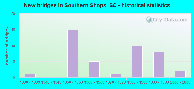
- New bridges - historical statistics
- 11930-1939
- 151950-1959
- 51960-1969
- 11970-1979
- 101980-1989
- 81990-1999
- 22000-2009

- Reconstructed bridges - Historical Statistics
- 11960-1969
- 01970-1979
- 11980-1989


- Bridge Condition - Deck
- 28.6%Very good
- 47.6%Good
- 14.3%Satisfactory
- 9.5%Fair

- Bridge Condition - Superstructure
- 28.6%Very good
- 38.1%Good
- 9.5%Satisfactory
- 14.3%Fair
- 9.5%Poor

- Bridge Condition - Substructure
- 28.6%Very good
- 28.6%Good
- 23.8%Satisfactory
- 19.0%Fair

- Bridge Condition - Channel
- 60.0%Very good
- 40.0%Good

- Bridge Condition - Culverts
- 33.3%Good
- 66.7%Satisfactory
Find on map >> Show street view
Structure Number: 616, Location: 4.0 MI E INMAN (Lat: 35.020003, Lng: -82.024544), Route carried "on" structure: US 176, Year Built: 1932, Year Reconstructed: 1967, Status: Open, Structure Length: 1.04m (3.41ft), Average Daily Traffic: 12,100 (year 2021), Truck Traffic: 6%, Average Future Daily Traffic: 24,079 (year 2041), Design Load: H 20, Features Intersected: LAWSON FORK CREEK
Minimum Vertical Clearance: 30+ m (98+ ft), Kilometerpoint: 28.455, Lanes on structure: 2, Base Highway Network: Yes, Owner: State Highway Agency, Approaching Roadway Width: 8.1m (26.6ft), Material/Design: Concrete, Design/Construction: Culvert, Number Of Spans In Main Unit: 3, Length of Maximum Span: 3.0m (9.8ft), Curb-To-Curb Width: 9.4m (30.8ft), Out-to-Out Width: 15.5m (50.9ft)
Condition: Channel: Very good, Culverts: Satisfactory, Operating Rating: 33.7 metric tons, Method Used To Determine Operating Rating: Load and Resistance Factor Rating (LRFR) rating reported by rating factor(RF) method using HL-93 loadings, Inventory Rating: 25.9 metric tons, Method Used To Determine Inventory Rating: Load and Resistance Factor Rating (LRFR) rating reported by rating factor(RF) method using HL-93 loadings, Structural Evaluation: Equal to present minimum criteria, Deck Geometry: Meets minimum limits, Waterway Adequacy: Equal to present desirable criteria, Approach Roadway Alignment: Equal to present desirable criteria, Length Of Structure Improvement: 1.04m (3.41ft), Designated Inspection Frequency: Every 24 months, Inspection Date: January 2022
Find on map >> Show street view
Structure Number: 2621, Location: 4.0 MI NW SPARTANBURG (Lat: 34.996297, Lng: -81.978044), Route carried "on" structure: State highway 79, Year Built: 2005, Status: Open, Structure Length: 5.21m (17.09ft), Average Daily Traffic: 12,200 (year 2020), Truck Traffic: 3%, Average Future Daily Traffic: 18,300 (year 2040), Design Load: HS 20, Features Intersected: U.S. 176
Minimum Vertical Clearance: 30+ m (98+ ft), Kilometerpoint: 4.649, Lanes on structure: 5, Lanes under structure: 5, Owner: State Highway Agency, Approaching Roadway Width: 20.1m (65.9ft), Material/Design: Prestressed concrete continuous, Design/Construction: Stringer/Multi-beam, Number Of Spans In Main Unit: 2, Length of Maximum Span: 26.2m (86.0ft), Curb or Sidewalk Widths: Left: 1.7m (5.6ft), Right: 1.7m (5.6ft), Curb-To-Curb Width: 20.1m (65.9ft), Out-to-Out Width: 23.8m (78.1ft)
Condition: Deck: Very good, Superstructure: Very good, Substructure: Very good, Operating Rating: 66.7 metric tons, Method Used To Determine Operating Rating: Load and Resistance Factor Rating (LRFR) rating reported by rating factor(RF) method using HL-93 loadings, Inventory Rating: 51.2 metric tons, Method Used To Determine Inventory Rating: Load and Resistance Factor Rating (LRFR) rating reported by rating factor(RF) method using HL-93 loadings, Structural Evaluation: Equal to present desirable criteria, Deck Geometry: Somewhat better than minimum adequacy, Underclear: Equal to present minimum criteria, Approach Roadway Alignment: Superior to present desirable criteria, Length Of Structure Improvement: 5.21m (17.09ft), Designated Inspection Frequency: Every 24 months, Inspection Date: September 2021, Deck Structure Type: Concrete Cast-file-Place, Wearing Surface/Protective System: Wearing Surface: Monolithic Concrete
Find on map >> Show street view
Structure Number: 2837, Location: 3.2 MI NW SPARTANBURG (Lat: 34.983697, Lng: -81.972986), Route carried "on" structure: State highway 85, Year Built: 1958, Status: Open, Structure Length: 4.85m (15.91ft), Average Daily Traffic: 31,200 (year 2020), Truck Traffic: 11%, Average Future Daily Traffic: 47,736 (year 2040), Design Load: HS 20, Features Intersected: SC 56 EB
Minimum Vertical Clearance: 30+ m (98+ ft), Kilometerpoint: 6.624, Lanes on structure: 4, Lanes under structure: 2, Base Highway Network: Yes, Owner: State Highway Agency, Approaching Roadway Width: 21.9m (71.9ft), Skew: 30 degrees, Material/Design: Concrete, Design/Construction: Tee Beam, Number Of Spans In Main Unit: 3, Length of Maximum Span: 16.2m (53.1ft), Curb-To-Curb Width: 17.1m (56.1ft), Out-to-Out Width: 18.3m (60.0ft)
Condition: Deck: Very good, Superstructure: Fair, Substructure: Fair, Operating Rating: 43.4 metric tons, Method Used To Determine Operating Rating: Load and Resistance Factor Rating (LRFR) rating reported by rating factor(RF) method using HL-93 loadings, Inventory Rating: 32.4 metric tons, Method Used To Determine Inventory Rating: Load and Resistance Factor Rating (LRFR) rating reported by rating factor(RF) method using HL-93 loadings, Structural Evaluation: Somewhat better than minimum adequacy, Deck Geometry: High priority of corrective action, Underclear: Meets minimum limits, Approach Roadway Alignment: Equal to present desirable criteria, Length Of Structure Improvement: 5.77m (18.93ft), Designated Inspection Frequency: Every 24 months, Inspection Date: Febuary 2020, Bridge Improvement Cost: $139,000, Roadway Improvement Cost: $35,000, Total Project Cost: $209,000 ( Estimate for 2021), Deck Structure Type: Concrete Cast-file-Place, Wearing Surface/Protective System: Wearing Surface: Bituminous
Find on map >> Show street view
Structure Number: 2838, Location: 4.0 MI NW OF SPARTANBURG (Lat: 34.984408, Lng: -81.972047), Route carried "on" structure: State highway 85, Year Built: 1958, Status: Open, Structure Length: 4.85m (15.91ft), Average Daily Traffic: 31,200 (year 2020), Truck Traffic: 11%, Average Future Daily Traffic: 47,736 (year 2040), Design Load: HS 20, Features Intersected: SC 56 WB
Minimum Vertical Clearance: 30+ m (98+ ft), Kilometerpoint: 6.740, Lanes on structure: 4, Lanes under structure: 2, Base Highway Network: Yes, Owner: State Highway Agency, Approaching Roadway Width: 20.7m (67.9ft), Skew: 30 degrees, Material/Design: Concrete, Design/Construction: Tee Beam, Number Of Spans In Main Unit: 3, Length of Maximum Span: 16.2m (53.1ft), Curb-To-Curb Width: 17.1m (56.1ft), Out-to-Out Width: 18.0m (59.1ft)
Condition: Deck: Very good, Superstructure: Satisfactory, Substructure: Good, Operating Rating: 41.8 metric tons, Method Used To Determine Operating Rating: Load and Resistance Factor Rating (LRFR) rating reported by rating factor(RF) method using HL-93 loadings, Inventory Rating: 32.1 metric tons, Method Used To Determine Inventory Rating: Load and Resistance Factor Rating (LRFR) rating reported by rating factor(RF) method using HL-93 loadings, Structural Evaluation: Equal to present minimum criteria, Deck Geometry: High priority of corrective action, Underclear: Meets minimum limits, Approach Roadway Alignment: Equal to present desirable criteria, Length Of Structure Improvement: 5.77m (18.93ft), Designated Inspection Frequency: Every 24 months, Inspection Date: Febuary 2020, Bridge Improvement Cost: $139,000, Roadway Improvement Cost: $35,000, Total Project Cost: $209,000 ( Estimate for 2021), Deck Structure Type: Concrete Cast-file-Place, Wearing Surface/Protective System: Wearing Surface: Bituminous
Find on map >> Show street view
Structure Number: 2852, Location: 4.0 MI W SPARTANBURG (Lat: 34.970211, Lng: -81.998953), Route carried "on" structure: State highway 525, Year Built: 1958, Status: Open, Structure Length: 7.62m (25.00ft), Average Daily Traffic: 10,000 (year 2020), Truck Traffic: 5%, Average Future Daily Traffic: 15,000 (year 2040), Design Load: H 20, Features Intersected: SC 85
Minimum Vertical Clearance: 5.03m (16.50ft), Kilometerpoint: 1.822, Lanes on structure: 2, Lanes under structure: 4, Owner: State Highway Agency, Approaching Roadway Width: 8.5m (27.9ft), Skew: 3 degrees, Material/Design: Prestressed concrete, Design/Construction: Stringer/Multi-beam, Number Of Spans In Main Unit: 4, Length of Maximum Span: 19.8m (65.0ft), Curb-To-Curb Width: 8.5m (27.9ft), Out-to-Out Width: 9.8m (32.2ft)
Condition: Deck: Fair, Superstructure: Poor, Substructure: Fair, Operating Rating: 24.3 metric tons, Method Used To Determine Operating Rating: Load and Resistance Factor Rating (LRFR) rating reported by rating factor(RF) method using HL-93 loadings, Inventory Rating: 18.8 metric tons, Method Used To Determine Inventory Rating: Load and Resistance Factor Rating (LRFR) rating reported by rating factor(RF) method using HL-93 loadings, Structural Evaluation: Meets minimum limits, Deck Geometry: Meets minimum limits, Underclear: High priority of replacement, Approach Roadway Alignment: Equal to present minimum criteria, Length Of Structure Improvement: 8.66m (28.41ft), Designated Inspection Frequency: Every 12 months, Inspection Date: September 2021, Bridge Improvement Cost: $1,095,000, Roadway Improvement Cost: $274,000, Total Project Cost: $1,643,000 ( Estimate for 2021), Deck Structure Type: Concrete Cast-file-Place, Wearing Surface/Protective System: Wearing Surface: Monolithic Concrete
Find on map >> Show street view
Structure Number: 3086, Location: 5.5 MI SE INMAN (Lat: 34.993992, Lng: -82.020358), Route carried "on" structure: Interstate 26, Year Built: 1959, Status: Open, Structure Length: 5.49m (18.01ft), Average Daily Traffic: 21,900 (year 2020), Truck Traffic: 9%, Average Future Daily Traffic: 27,375 (year 2040), Design Load: HS 20, Features Intersected: NS RR
Minimum Vertical Clearance: 30+ m (98+ ft), Kilometerpoint: 26.604, Lanes on structure: 2, Base Highway Network: Yes, Owner: State Highway Agency, Approaching Roadway Width: 11.3m (37.1ft), Skew: 3 degrees, Material/Design: Steel, Design/Construction: Stringer/Multi-beam, Number Of Spans In Main Unit: 3, Length of Maximum Span: 18.3m (60.0ft), Curb-To-Curb Width: 8.5m (27.9ft), Out-to-Out Width: 9.8m (32.2ft)
Condition: Deck: Satisfactory, Superstructure: Satisfactory, Substructure: Satisfactory, Operating Rating: 57.0 metric tons, Method Used To Determine Operating Rating: Load and Resistance Factor Rating (LRFR) rating reported by rating factor(RF) method using HL-93 loadings, Inventory Rating: 44.1 metric tons, Method Used To Determine Inventory Rating: Load and Resistance Factor Rating (LRFR) rating reported by rating factor(RF) method using HL-93 loadings, Structural Evaluation: Equal to present minimum criteria, Deck Geometry: High priority of replacement, Underclear: Better than present minimum criteria, Approach Roadway Alignment: Equal to present desirable criteria, Length Of Structure Improvement: 6.44m (21.13ft), Designated Inspection Frequency: Every 24 months, Inspection Date: August 2021, Bridge Improvement Cost: $430,000, Roadway Improvement Cost: $108,000, Total Project Cost: $645,000 ( Estimate for 2021), Deck Structure Type: Concrete Cast-file-Place, Wearing Surface/Protective System: Wearing Surface: Bituminous
Find on map >> Show street view
Structure Number: 3089, Location: 5.5 MI SE INMAN (Lat: 34.993889, Lng: -82.020164), Route carried "on" structure: Interstate 26, Year Built: 1959, Status: Open, Structure Length: 5.49m (18.01ft), Average Daily Traffic: 21,900 (year 2020), Truck Traffic: 9%, Average Future Daily Traffic: 27,375 (year 2040), Design Load: HS 20, Features Intersected: NS RR
Minimum Vertical Clearance: 30+ m (98+ ft), Kilometerpoint: 26.609, Lanes on structure: 2, Base Highway Network: Yes, Owner: State Highway Agency, Approaching Roadway Width: 10.1m (33.1ft), Skew: 3 degrees, Material/Design: Steel, Design/Construction: Stringer/Multi-beam, Number Of Spans In Main Unit: 3, Length of Maximum Span: 18.3m (60.0ft), Curb-To-Curb Width: 8.5m (27.9ft), Out-to-Out Width: 9.8m (32.2ft)
Condition: Deck: Fair, Superstructure: Good, Substructure: Satisfactory, Operating Rating: 59.0 metric tons, Method Used To Determine Operating Rating: Load and Resistance Factor Rating (LRFR) rating reported by rating factor(RF) method using HL-93 loadings, Inventory Rating: 45.4 metric tons, Method Used To Determine Inventory Rating: Load and Resistance Factor Rating (LRFR) rating reported by rating factor(RF) method using HL-93 loadings, Structural Evaluation: Equal to present minimum criteria, Deck Geometry: High priority of replacement, Underclear: Equal to present minimum criteria, Approach Roadway Alignment: Equal to present desirable criteria, Length Of Structure Improvement: 6.44m (21.13ft), Designated Inspection Frequency: Every 24 months, Inspection Date: August 2021, Bridge Improvement Cost: $430,000, Roadway Improvement Cost: $108,000, Total Project Cost: $645,000 ( Estimate for 2021), Deck Structure Type: Concrete Cast-file-Place, Wearing Surface/Protective System: Wearing Surface: Bituminous
Find on map >> Show street view
Structure Number: 309, Location: 4.3 MI NW SPARTANBURG (Lat: 34.968219, Lng: -82.005986), Route carried "on" structure: Interstate 26, Year Built: 1959, Status: Open, Structure Length: 7.19m (23.59ft), Average Daily Traffic: 21,950 (year 2020), Truck Traffic: 9%, Average Future Daily Traffic: 27,438 (year 2040), Design Load: HS 20, Features Intersected: SC 85
Minimum Vertical Clearance: 30+ m (98+ ft), Kilometerpoint: 29.871, Lanes on structure: 3, Lanes under structure: 6, Base Highway Network: Yes, Owner: State Highway Agency, Approaching Roadway Width: 11.3m (37.1ft), Skew: 11 degrees, Material/Design: Steel, Design/Construction: Stringer/Multi-beam, Number Of Spans In Main Unit: 4, Length of Maximum Span: 19.8m (65.0ft), Curb-To-Curb Width: 12.2m (40.0ft), Out-to-Out Width: 14.0m (45.9ft)
Condition: Deck: Good, Superstructure: Poor, Substructure: Satisfactory, Operating Rating: 44.7 metric tons, Method Used To Determine Operating Rating: Load and Resistance Factor Rating (LRFR) rating reported by rating factor(RF) method using HL-93 loadings, Inventory Rating: 34.3 metric tons, Method Used To Determine Inventory Rating: Load and Resistance Factor Rating (LRFR) rating reported by rating factor(RF) method using HL-93 loadings, Structural Evaluation: Meets minimum limits, Deck Geometry: High priority of corrective action, Underclear: High priority of replacement, Approach Roadway Alignment: Equal to present desirable criteria, Length Of Structure Improvement: 8.21m (26.94ft), Designated Inspection Frequency: Every 12 months, Inspection Date: Febuary 2021, Bridge Improvement Cost: $1,039,000, Roadway Improvement Cost: $260,000, Total Project Cost: $1,559,000 ( Estimate for 2021), Deck Structure Type: Concrete Cast-file-Place, Wearing Surface/Protective System: Wearing Surface: Monolithic Concrete
Find on map >> Show street view
Structure Number: 3111, Location: 5.7 MI NW SPARTANBURG (Lat: 34.991036, Lng: -82.020142), Route carried "on" structure: State highway 40, Year Built: 1959, Status: Open, Structure Length: 6.40m (21.00ft), Average Daily Traffic: 5,800 (year 2020), Truck Traffic: 6%, Average Future Daily Traffic: 8,410 (year 2040), Design Load: HS 20, Features Intersected: I-26
Minimum Vertical Clearance: 5.11m (16.77ft), Kilometerpoint: 9.529, Lanes on structure: 2, Lanes under structure: 4, Owner: State Highway Agency, Approaching Roadway Width: 10.1m (33.1ft), Skew: 1 degrees, Material/Design: Prestressed concrete, Design/Construction: Stringer/Multi-beam, Number Of Spans In Main Unit: 4, Length of Maximum Span: 16.8m (55.1ft), Curb-To-Curb Width: 8.5m (27.9ft), Out-to-Out Width: 9.8m (32.2ft)
Condition: Deck: Good, Superstructure: Good, Substructure: Good, Operating Rating: 53.8 metric tons, Method Used To Determine Operating Rating: Load and Resistance Factor Rating (LRFR) rating reported by rating factor(RF) method using HL-93 loadings, Inventory Rating: 27.9 metric tons, Method Used To Determine Inventory Rating: Load and Resistance Factor Rating (LRFR) rating reported by rating factor(RF) method using HL-93 loadings, Structural Evaluation: Better than present minimum criteria, Deck Geometry: Meets minimum limits, Underclear: Somewhat better than minimum adequacy, Approach Roadway Alignment: Equal to present desirable criteria, Length Of Structure Improvement: 7.39m (24.25ft), Designated Inspection Frequency: Every 24 months, Inspection Date: August 2021, Bridge Improvement Cost: $368,000, Roadway Improvement Cost: $92,000, Total Project Cost: $552,000 ( Estimate for 2021), Deck Structure Type: Concrete Cast-file-Place, Wearing Surface/Protective System: Wearing Surface: Bituminous
Find on map >> Show street view
Structure Number: 3115, Location: 4.5 MI SE INMAN (Lat: 35.009564, Lng: -82.028264), Route carried "on" structure: State highway 60, Year Built: 1959, Year Reconstructed: 1986, Status: Open, Structure Length: 6.89m (22.60ft), Average Daily Traffic: 9,300 (year 2021), Truck Traffic: 5%, Average Future Daily Traffic: 13,950 (year 2041), Design Load: HS 15, Features Intersected: I-26
Minimum Vertical Clearance: 5.31m (17.42ft), Kilometerpoint: 1.072, Lanes on structure: 4, Lanes under structure: 4, Owner: State Highway Agency, Approaching Roadway Width: 18.9m (62.0ft), Skew: 21 degrees, Material/Design: Prestressed concrete, Design/Construction: Stringer/Multi-beam, Number Of Spans In Main Unit: 4, Length of Maximum Span: 18.3m (60.0ft), Curb or Sidewalk Widths: Left: 1.5m (4.9ft), Right: 1.5m (4.9ft), Curb-To-Curb Width: 19.5m (64.0ft), Out-to-Out Width: 23.2m (76.1ft)
Condition: Deck: Good, Superstructure: Fair, Substructure: Fair, Operating Rating: 52.2 metric tons, Method Used To Determine Operating Rating: Load and Resistance Factor Rating (LRFR) rating reported by rating factor(RF) method using HL-93 loadings, Inventory Rating: 36.9 metric tons, Method Used To Determine Inventory Rating: Load and Resistance Factor Rating (LRFR) rating reported by rating factor(RF) method using HL-93 loadings, Structural Evaluation: Somewhat better than minimum adequacy, Deck Geometry: Better than present minimum criteria, Underclear: Equal to present minimum criteria, Approach Roadway Alignment: Equal to present desirable criteria, Length Of Structure Improvement: 6.89m (22.60ft), Designated Inspection Frequency: Every 24 months, Inspection Date: August 2021, Deck Structure Type: Concrete Cast-file-Place, Wearing Surface/Protective System: Wearing Surface: Bituminous
Find on map >> Show street view
Structure Number: 3476, Location: 3.7 MI SE INMAN (Lat: 35.019306, Lng: -82.034933), Route carried "on" structure: Interstate 26, Year Built: 1960, Status: Open, Structure Length: 1.22m (4.00ft), Average Daily Traffic: 38,600 (year 2020), Truck Traffic: 9%, Average Future Daily Traffic: 48,250 (year 2040), Design Load: H 20, Features Intersected: LAWSON FORK CREEK
Minimum Vertical Clearance: 30+ m (98+ ft), Kilometerpoint: 23.442, Lanes on structure: 4, Base Highway Network: Yes, Owner: State Highway Agency, Approaching Roadway Width: 24.4m (80.1ft), Material/Design: Concrete, Design/Construction: Culvert, Number Of Spans In Main Unit: 3, Length of Maximum Span: 3.7m (12.1ft), Curb-To-Curb Width: 24.4m (80.1ft), Out-to-Out Width: 45.7m (149.9ft)
Condition: Channel: Good, Culverts: Satisfactory, Operating Rating: 32.4 metric tons, Method Used To Determine Operating Rating: Load and Resistance Factor Rating (LRFR) rating reported by rating factor(RF) method using HL-93 loadings, Inventory Rating: 32.4 metric tons, Method Used To Determine Inventory Rating: Load and Resistance Factor Rating (LRFR) rating reported by rating factor(RF) method using HL-93 loadings, Structural Evaluation: Equal to present minimum criteria, Deck Geometry: Superior to present desirable criteria, Waterway Adequacy: Equal to present desirable criteria, Approach Roadway Alignment: Equal to present desirable criteria, Length Of Structure Improvement: 1.22m (4.00ft), Designated Inspection Frequency: Every 24 months, Inspection Date: Febuary 2020
Find on map >> Show street view
Structure Number: 3477, Location: 3.9 MI SE INMAN (Lat: 35.015722, Lng: -82.033467), Route carried "on" structure: Interstate 26, Year Built: 1960, Status: Open, Structure Length: 0.70m (2.30ft), Average Daily Traffic: 38,600 (year 2020), Truck Traffic: 9%, Average Future Daily Traffic: 48,250 (year 2040), Design Load: H 20, Features Intersected: JAMES CREEK
Minimum Vertical Clearance: 30+ m (98+ ft), Kilometerpoint: 23.867, Lanes on structure: 4, Base Highway Network: Yes, Owner: State Highway Agency, Approaching Roadway Width: 24.4m (80.1ft), Material/Design: Concrete, Design/Construction: Culvert, Number Of Spans In Main Unit: 2, Length of Maximum Span: 3.0m (9.8ft), Curb-To-Curb Width: 24.4m (80.1ft), Out-to-Out Width: 45.7m (149.9ft)
Condition: Channel: Very good, Culverts: Good, Operating Rating: 61.6 metric tons, Method Used To Determine Operating Rating: Load and Resistance Factor Rating (LRFR) rating reported by rating factor(RF) method using HL-93 loadings, Inventory Rating: 47.6 metric tons, Method Used To Determine Inventory Rating: Load and Resistance Factor Rating (LRFR) rating reported by rating factor(RF) method using HL-93 loadings, Structural Evaluation: Better than present minimum criteria, Deck Geometry: Superior to present desirable criteria, Waterway Adequacy: Equal to present desirable criteria, Approach Roadway Alignment: Equal to present desirable criteria, Length Of Structure Improvement: 0.70m (2.30ft), Designated Inspection Frequency: Every 24 months, Inspection Date: Febuary 2020
Find on map >> Show street view
Structure Number: 5156, Location: 4.0 MI E OF INMAN (Lat: 35.019972, Lng: -82.024783), Route carried "on" structure: US 176, Year Built: 1967, Status: Open, Structure Length: 5.18m (16.99ft), Average Daily Traffic: 12,100 (year 2021), Truck Traffic: 6%, Average Future Daily Traffic: 24,079 (year 2041), Design Load: H 20, Features Intersected: LAWSONS FORK CREEK
Minimum Vertical Clearance: 30+ m (98+ ft), Kilometerpoint: 28.450, Lanes on structure: 2, Base Highway Network: Yes, Owner: State Highway Agency, Approaching Roadway Width: 8.1m (26.6ft), Material/Design: Concrete, Design/Construction: Tee Beam, Number Of Spans In Main Unit: 5, Length of Maximum Span: 12.2m (40.0ft), Curb-To-Curb Width: 9.1m (29.9ft), Out-to-Out Width: 10.1m (33.1ft)
Condition: Deck: Satisfactory, Superstructure: Good, Substructure: Fair, Channel: Very good, Operating Rating: 33.4 metric tons, Method Used To Determine Operating Rating: Load and Resistance Factor Rating (LRFR) rating reported by rating factor(RF) method using HL-93 loadings, Inventory Rating: 25.6 metric tons, Method Used To Determine Inventory Rating: Load and Resistance Factor Rating (LRFR) rating reported by rating factor(RF) method using HL-93 loadings, Structural Evaluation: Somewhat better than minimum adequacy, Deck Geometry: Meets minimum limits, Waterway Adequacy: Better than present minimum criteria, Approach Roadway Alignment: Equal to present desirable criteria, Length Of Structure Improvement: 5.18m (16.99ft), Designated Inspection Frequency: Every 24 months, Inspection Date: January 2022, Deck Structure Type: Concrete Cast-file-Place, Wearing Surface/Protective System: Wearing Surface: Monolithic Concrete
Find on map >> Show street view
Structure Number: 5157, Location: 3.0 MI NW OF SPARTANBURG (Lat: 34.996389, Lng: -81.999722), Route carried "on" structure: State highway 56, Year Built: 1967, Status: Open, Structure Length: 6.58m (21.59ft), Average Daily Traffic: 9,500 (year 2020), Truck Traffic: 5%, Average Future Daily Traffic: 13,775 (year 2040), Design Load: HS 20, Features Intersected: U.S. 176 EB LANE
Minimum Vertical Clearance: 30+ m (98+ ft), Kilometerpoint: 52.428, Lanes on structure: 4, Lanes under structure: 2, Owner: State Highway Agency, Approaching Roadway Width: 10.4m (34.1ft), Skew: 4 degrees, Material/Design: Steel, Design/Construction: Stringer/Multi-beam, Number Of Spans In Main Unit: 3, Length of Maximum Span: 21.9m (71.9ft), Curb or Sidewalk Widths: Left: 0.4m (1.3ft), Right: 0.4m (1.3ft), Curb-To-Curb Width: 11.5m (37.7ft), Out-to-Out Width: 12.8m (42.0ft)
Condition: Deck: Satisfactory, Superstructure: Fair, Substructure: Good, Operating Rating: 62.5 metric tons, Method Used To Determine Operating Rating: Load and Resistance Factor Rating (LRFR) rating reported by rating factor(RF) method using HL-93 loadings, Inventory Rating: 48.3 metric tons, Method Used To Determine Inventory Rating: Load and Resistance Factor Rating (LRFR) rating reported by rating factor(RF) method using HL-93 loadings, Structural Evaluation: Somewhat better than minimum adequacy, Deck Geometry: High priority of replacement, Underclear: Somewhat better than minimum adequacy, Approach Roadway Alignment: Equal to present desirable criteria, Length Of Structure Improvement: 7.58m (24.87ft), Designated Inspection Frequency: Every 24 months, Inspection Date: Febuary 2020, Bridge Improvement Cost: $351,000, Roadway Improvement Cost: $88,000, Total Project Cost: $527,000 ( Estimate for 2021), Deck Structure Type: Concrete Cast-file-Place, Wearing Surface/Protective System: Wearing Surface: Monolithic Concrete
Find on map >> Show street view
Structure Number: 6933, Location: 5.0MI NW SPARTANBURG (Lat: 34.992656, Lng: -82.002433), Route carried "on" structure: State highway 40, Year Built: 1976, Status: Open, Structure Length: 0.91m (2.99ft), Average Daily Traffic: 700 (year 2020), Truck Traffic: 5%, Average Future Daily Traffic: 896 (year 2040), Design Load: H 15, Features Intersected: BR TO LAWSON FORK CR
Minimum Vertical Clearance: 30+ m (98+ ft), Kilometerpoint: 11.513, Lanes on structure: 2, Owner: State Highway Agency, Approaching Roadway Width: 6.9m (22.6ft), Material/Design: Concrete, Design/Construction: Slab, Number Of Spans In Main Unit: 2, Length of Maximum Span: 4.6m (15.1ft), Curb-To-Curb Width: 7.9m (25.9ft), Out-to-Out Width: 8.4m (27.6ft)
Condition: Deck: Good, Superstructure: Good, Substructure: Good, Channel: Good, Operating Rating: 26.9 metric tons, Method Used To Determine Operating Rating: Load and Resistance Factor Rating (LRFR) rating reported by rating factor(RF) method using HL-93 loadings, Inventory Rating: 20.7 metric tons, Method Used To Determine Inventory Rating: Load and Resistance Factor Rating (LRFR) rating reported by rating factor(RF) method using HL-93 loadings, Structural Evaluation: Somewhat better than minimum adequacy, Deck Geometry: Somewhat better than minimum adequacy, Waterway Adequacy: Equal to present minimum criteria, Approach Roadway Alignment: Equal to present desirable criteria, Length Of Structure Improvement: 0.91m (2.99ft), Designated Inspection Frequency: Every 24 months, Inspection Date: August 2021, Deck Structure Type: Concrete Precast Panels, Wearing Surface/Protective System: Wearing Surface: Bituminous
Find on map >> Show street view
Structure Number: 8205, Location: 5.0 MI NW OF SPARTANBURG (Lat: 34.978075, Lng: -82.011781), Route carried "on" structure: Interstate 85, Year Built: 1988, Status: Open, Structure Length: 8.26m (27.10ft), Average Daily Traffic: 31,700 (year 2020), Truck Traffic: 9%, Average Future Daily Traffic: 39,625 (year 2040), Design Load: HS 20, Features Intersected: I-26
Minimum Vertical Clearance: 30+ m (98+ ft), Kilometerpoint: 113.237, Lanes on structure: 3, Lanes under structure: 6, Base Highway Network: Yes, Owner: State Highway Agency, Approaching Roadway Width: 20.7m (67.9ft), Skew: 3 degrees, Material/Design: Steel continuous, Design/Construction: Stringer/Multi-beam, Number Of Spans In Main Unit: 2, Number Of Approach Spans: 2, Length of Maximum Span: 25.3m (83.0ft), Curb-To-Curb Width: 20.8m (68.2ft), Out-to-Out Width: 21.9m (71.9ft)
Condition: Deck: Very good, Superstructure: Very good, Substructure: Very good, Operating Rating: 24.9 metric tons, Method Used To Determine Operating Rating: Load and Resistance Factor Rating (LRFR) rating reported by rating factor(RF) method using HL-93 loadings, Inventory Rating: 19.1 metric tons, Method Used To Determine Inventory Rating: Load and Resistance Factor Rating (LRFR) rating reported by rating factor(RF) method using HL-93 loadings, Structural Evaluation: Meets minimum limits, Deck Geometry: Superior to present desirable criteria, Underclear: Equal to present minimum criteria, Approach Roadway Alignment: Superior to present desirable criteria, Length Of Structure Improvement: 8.26m (27.10ft), Designated Inspection Frequency: Every 24 months, Inspection Date: Febuary 2020, Deck Structure Type: Concrete Cast-file-Place, Wearing Surface/Protective System: Wearing Surface: Monolithic Concrete
Find on map >> Show street view
Structure Number: 8301, Location: 5.0 MI NW OF SPARTANBURG (Lat: 34.978272, Lng: -82.012050), Route carried "on" structure: Interstate 85, Year Built: 1989, Status: Open, Structure Length: 8.26m (27.10ft), Average Daily Traffic: 31,700 (year 2020), Truck Traffic: 9%, Average Future Daily Traffic: 39,625 (year 2040), Design Load: HS 20+Mod, Features Intersected: I-26
Minimum Vertical Clearance: 30+ m (98+ ft), Kilometerpoint: 113.262, Lanes on structure: 4, Lanes under structure: 6, Base Highway Network: Yes, Owner: State Highway Agency, Approaching Roadway Width: 20.7m (67.9ft), Skew: 3 degrees, Material/Design: Steel continuous, Design/Construction: Stringer/Multi-beam, Number Of Spans In Main Unit: 2, Number Of Approach Spans: 2, Length of Maximum Span: 25.3m (83.0ft), Curb-To-Curb Width: 20.8m (68.2ft), Out-to-Out Width: 21.9m (71.9ft)
Condition: Deck: Very good, Superstructure: Very good, Substructure: Very good, Operating Rating: 24.6 metric tons, Method Used To Determine Operating Rating: Load and Resistance Factor Rating (LRFR) rating reported by rating factor(RF) method using HL-93 loadings, Inventory Rating: 18.8 metric tons, Method Used To Determine Inventory Rating: Load and Resistance Factor Rating (LRFR) rating reported by rating factor(RF) method using HL-93 loadings, Structural Evaluation: Meets minimum limits, Deck Geometry: Equal to present minimum criteria, Underclear: Equal to present minimum criteria, Approach Roadway Alignment: Superior to present desirable criteria, Length Of Structure Improvement: 8.26m (27.10ft), Designated Inspection Frequency: Every 24 months, Inspection Date: Febuary 2020, Deck Structure Type: Concrete Cast-file-Place, Wearing Surface/Protective System: Wearing Surface: Monolithic Concrete
Find on map >> Show street view
Structure Number: 8302, Location: 4.2 MI. NW SPARTANBURG (Lat: 34.983642, Lng: -82.002264), Route carried "on" structure: State highway 65, Year Built: 1989, Status: Open, Structure Length: 9.14m (29.99ft), Average Daily Traffic: 6,100 (year 2020), Truck Traffic: 7%, Average Future Daily Traffic: 8,845 (year 2040), Design Load: HS 20, Features Intersected: I-85 (NEW LOCATION)
Minimum Vertical Clearance: 7.01m (23.00ft), Kilometerpoint: 0.663, Lanes on structure: 2, Lanes under structure: 7, Owner: State Highway Agency, Approaching Roadway Width: 7.9m (25.9ft), Skew: 1 degrees, Material/Design: Steel continuous, Design/Construction: Stringer/Multi-beam, Number Of Spans In Main Unit: 4, Length of Maximum Span: 30.5m (100.1ft), Curb or Sidewalk Widths: Left: 1.5m (4.9ft), Right: 1.5m (4.9ft), Curb-To-Curb Width: 20.1m (65.9ft), Out-to-Out Width: 23.8m (78.1ft)
Condition: Deck: Good, Superstructure: Good, Substructure: Good, Operating Rating: 30.1 metric tons, Method Used To Determine Operating Rating: Load and Resistance Factor Rating (LRFR) rating reported by rating factor(RF) method using HL-93 loadings, Inventory Rating: 23.3 metric tons, Method Used To Determine Inventory Rating: Load and Resistance Factor Rating (LRFR) rating reported by rating factor(RF) method using HL-93 loadings, Structural Evaluation: Somewhat better than minimum adequacy, Deck Geometry: Superior to present desirable criteria, Underclear: High priority of corrective action, Approach Roadway Alignment: Equal to present desirable criteria, Length Of Structure Improvement: 9.17m (30.09ft), Designated Inspection Frequency: Every 24 months, Inspection Date: September 2021, Deck Structure Type: Concrete Cast-file-Place
Find on map >> Show street view
Structure Number: 8304, Location: 3 MI NW OF SPARTANBURG (Lat: 34.979367, Lng: -82.007739), Route carried "on" structure: State highway 839, Year Built: 1989, Status: Open, Structure Length: 16.20m (53.15ft), Average Daily Traffic: 1,000 (year 2020), Truck Traffic: 5%, Average Future Daily Traffic: 1,280 (year 2040), Design Load: HS 20+Mod, Features Intersected: I-85
Minimum Vertical Clearance: 5.97m (19.59ft), Kilometerpoint: 1.928, Lanes on structure: 2, Lanes under structure: 9, Owner: State Highway Agency, Approaching Roadway Width: 7.6m (24.9ft), Material/Design: Steel continuous, Design/Construction: Stringer/Multi-beam, Number Of Spans In Main Unit: 4, Length of Maximum Span: 51.2m (168.0ft), Curb-To-Curb Width: 13.4m (44.0ft), Out-to-Out Width: 14.4m (47.2ft)
Condition: Deck: Good, Superstructure: Good, Substructure: Satisfactory, Operating Rating: 43.1 metric tons, Method Used To Determine Operating Rating: Load and Resistance Factor Rating (LRFR) rating reported by rating factor(RF) method using HL-93 loadings, Inventory Rating: 33.4 metric tons, Method Used To Determine Inventory Rating: Load and Resistance Factor Rating (LRFR) rating reported by rating factor(RF) method using HL-93 loadings, Structural Evaluation: Equal to present minimum criteria, Deck Geometry: Superior to present desirable criteria, Underclear: Better than present minimum criteria, Approach Roadway Alignment: Equal to present desirable criteria, Length Of Structure Improvement: 16.15m (52.99ft), Designated Inspection Frequency: Every 24 months, Inspection Date: September 2021, Deck Structure Type: Concrete Cast-file-Place
Find on map >> Show street view
Structure Number: 8305, Location: 2 MI NW SPARTANBURG (Lat: 34.977044, Lng: -82.016061), Route carried "on" structure: State highway 910, Year Built: 1989, Status: Open, Structure Length: 13.47m (44.19ft), Average Daily Traffic: 1,200 (year 2020), Truck Traffic: 6%, Average Future Daily Traffic: 1,536 (year 2040), Design Load: HS 20, Features Intersected: I-85
Minimum Vertical Clearance: 6.22m (20.41ft), Kilometerpoint: 1.732, Lanes on structure: 2, Lanes under structure: 9, Owner: State Highway Agency, Approaching Roadway Width: 7.3m (24.0ft), Material/Design: Steel continuous, Design/Construction: Stringer/Multi-beam, Number Of Spans In Main Unit: 5, Length of Maximum Span: 46.0m (150.9ft), Curb-To-Curb Width: 13.4m (44.0ft), Out-to-Out Width: 14.4m (47.2ft)
Condition: Deck: Good, Superstructure: Good, Substructure: Satisfactory, Operating Rating: 36.6 metric tons, Method Used To Determine Operating Rating: Load and Resistance Factor Rating (LRFR) rating reported by rating factor(RF) method using HL-93 loadings, Inventory Rating: 28.2 metric tons, Method Used To Determine Inventory Rating: Load and Resistance Factor Rating (LRFR) rating reported by rating factor(RF) method using HL-93 loadings, Structural Evaluation: Equal to present minimum criteria, Deck Geometry: Equal to present desirable criteria, Underclear: Better than present minimum criteria, Approach Roadway Alignment: Equal to present desirable criteria, Length Of Structure Improvement: 13.47m (44.19ft), Designated Inspection Frequency: Every 24 months, Inspection Date: September 2021, Deck Structure Type: Concrete Cast-file-Place
Find on map >> Show street view
Structure Number: 8388, Location: 5.0 MI NW OF SPARTANBURG (Lat: 34.977894, Lng: -82.011081), Route carried "on" structure: Ramp Interstate 85, Year Built: 1990, Status: Open, Structure Length: 23.74m (77.89ft), Average Daily Traffic: 8,200 (year 2020), Truck Traffic: 9%, Average Future Daily Traffic: 16,318 (year 2040), Design Load: HS 20+Mod, Features Intersected: I-26 & I-85
Minimum Vertical Clearance: 30+ m (98+ ft), Kilometerpoint: 112.120, Lanes on structure: 1, Lanes under structure: 12, Owner: State Highway Agency, Approaching Roadway Width: 8.2m (26.9ft), Material/Design: Steel continuous, Design/Construction: Stringer/Multi-beam, Number Of Spans In Main Unit: 7, Length of Maximum Span: 44.8m (147.0ft), Curb-To-Curb Width: 9.2m (30.2ft), Out-to-Out Width: 10.2m (33.5ft)
Condition: Deck: Good, Superstructure: Very good, Substructure: Very good, Operating Rating: 37.3 metric tons, Method Used To Determine Operating Rating: Load and Resistance Factor Rating (LRFR) rating reported by rating factor(RF) method using HL-93 loadings, Inventory Rating: 28.8 metric tons, Method Used To Determine Inventory Rating: Load and Resistance Factor Rating (LRFR) rating reported by rating factor(RF) method using HL-93 loadings, Structural Evaluation: Better than present minimum criteria, Deck Geometry: Superior to present desirable criteria, Underclear: Better than present minimum criteria, Approach Roadway Alignment: Equal to present desirable criteria, Length Of Structure Improvement: 23.74m (77.89ft), Designated Inspection Frequency: Every 24 months, Inspection Date: Febuary 2020, Deck Structure Type: Concrete Cast-file-Place, Wearing Surface/Protective System: Wearing Surface: Monolithic Concrete
Find on map >> Show street view
Structure Number: 839, Location: 5.0 MI NW OF SPARTANBURG (Lat: 34.978292, Lng: -82.012683), Route carried "on" structure: Ramp Interstate 85, Year Built: 1990, Status: Open, Structure Length: 23.74m (77.89ft), Average Daily Traffic: 6,400 (year 2020), Truck Traffic: 9%, Average Future Daily Traffic: 12,736 (year 2040), Design Load: HS 20, Features Intersected: I-26 & I-85
Minimum Vertical Clearance: 30+ m (98+ ft), Kilometerpoint: 112.496, Lanes on structure: 1, Lanes under structure: 12, Owner: State Highway Agency, Approaching Roadway Width: 8.2m (26.9ft), Material/Design: Steel continuous, Design/Construction: Stringer/Multi-beam, Length of Maximum Span: 44.8m (147.0ft), Curb-To-Curb Width: 9.2m (30.2ft), Out-to-Out Width: 10.2m (33.5ft)
Condition: Deck: Good, Superstructure: Very good, Substructure: Very good, Operating Rating: 37.3 metric tons, Method Used To Determine Operating Rating: Load and Resistance Factor Rating (LRFR) rating reported by rating factor(RF) method using HL-93 loadings, Inventory Rating: 28.8 metric tons, Method Used To Determine Inventory Rating: Load and Resistance Factor Rating (LRFR) rating reported by rating factor(RF) method using HL-93 loadings, Structural Evaluation: Better than present minimum criteria, Deck Geometry: Superior to present desirable criteria, Underclear: Equal to present minimum criteria, Approach Roadway Alignment: Equal to present desirable criteria, Length Of Structure Improvement: 23.74m (77.89ft), Designated Inspection Frequency: Every 24 months, Inspection Date: Febuary 2020, Deck Structure Type: Concrete Cast-file-Place, Wearing Surface/Protective System: Wearing Surface: Monolithic Concrete
Find on map >> Show street view
Structure Number: 8393, Location: 4.5 MI NW OF SPARTANBURG (Lat: 34.971408, Lng: -82.006714), Route carried "on" structure: State highway 968, Year Built: 1990, Status: Open, Structure Length: 6.58m (21.59ft), Average Daily Traffic: 1,200 (year 2020), Truck Traffic: 5%, Average Future Daily Traffic: 1,536 (year 2040), Design Load: HS 20, Features Intersected: I-26
Minimum Vertical Clearance: 6.60m (21.65ft), Kilometerpoint: 0.295, Lanes on structure: 2, Lanes under structure: 6, Owner: State Highway Agency, Approaching Roadway Width: 7.2m (23.6ft), Material/Design: Steel continuous, Design/Construction: Stringer/Multi-beam, Number Of Spans In Main Unit: 4, Length of Maximum Span: 22.3m (73.2ft), Curb-To-Curb Width: 12.2m (40.0ft), Out-to-Out Width: 13.2m (43.3ft)
Condition: Deck: Good, Superstructure: Good, Substructure: Good, Operating Rating: 42.4 metric tons, Method Used To Determine Operating Rating: Load and Resistance Factor Rating (LRFR) rating reported by rating factor(RF) method using HL-93 loadings, Inventory Rating: 33.0 metric tons, Method Used To Determine Inventory Rating: Load and Resistance Factor Rating (LRFR) rating reported by rating factor(RF) method using HL-93 loadings, Structural Evaluation: Better than present minimum criteria, Deck Geometry: Better than present minimum criteria, Underclear: Equal to present minimum criteria, Approach Roadway Alignment: Equal to present desirable criteria, Length Of Structure Improvement: 6.59m (21.62ft), Designated Inspection Frequency: Every 24 months, Inspection Date: September 2021, Deck Structure Type: Concrete Cast-file-Place
Find on map >> Show street view
Structure Number: 8591, Location: 3.5 MI NW OF SPARTANBURG (Lat: 34.993978, Lng: -81.996083), Route carried "on" structure: State highway 56, Year Built: 1992, Status: Open, Structure Length: 8.35m (27.40ft), Average Daily Traffic: 9,500 (year 2020), Truck Traffic: 5%, Average Future Daily Traffic: 13,775 (year 2040), Design Load: HS 20, Features Intersected: I-85 (NEW)
Minimum Vertical Clearance: 30+ m (98+ ft), Kilometerpoint: 51.990, Lanes on structure: 5, Lanes under structure: 7, Owner: State Highway Agency, Approaching Roadway Width: 20.1m (65.9ft), Material/Design: Steel continuous, Design/Construction: Stringer/Multi-beam, Number Of Spans In Main Unit: 2, Number Of Approach Spans: 2, Length of Maximum Span: 29.3m (96.1ft), Curb or Sidewalk Widths: Left: 1.5m (4.9ft), Right: 1.5m (4.9ft), Curb-To-Curb Width: 20.3m (66.6ft), Out-to-Out Width: 23.9m (78.4ft)
Condition: Deck: Very good, Superstructure: Very good, Substructure: Very good, Operating Rating: 40.8 metric tons, Method Used To Determine Operating Rating: Load and Resistance Factor Rating (LRFR) rating reported by rating factor(RF) method using HL-93 loadings, Inventory Rating: 31.4 metric tons, Method Used To Determine Inventory Rating: Load and Resistance Factor Rating (LRFR) rating reported by rating factor(RF) method using HL-93 loadings, Structural Evaluation: Better than present minimum criteria, Deck Geometry: Somewhat better than minimum adequacy, Underclear: Better than present minimum criteria, Approach Roadway Alignment: Equal to present desirable criteria, Length Of Structure Improvement: 8.35m (27.40ft), Designated Inspection Frequency: Every 24 months, Inspection Date: Febuary 2020, Deck Structure Type: Concrete Cast-file-Place, Wearing Surface/Protective System: Wearing Surface: Monolithic Concrete
Find on map >> Show street view
Structure Number: 2621, Location: 4.0 MI NW SPARTANBURG (Lat: 34.996297, Lng: -81.978044), Route carried "under" structure: US 176, Year Built: 2005, Structure Length: 0. m, Average Daily Traffic: 17,800 (year 2020), Truck Traffic: 8%, Features Intersected: U.S. 176, Facility Carried by Structure: S-42-79
Minimum Vertical Clearance: 5.87m (19.26ft), Kilometerpoint: 33.909, Lanes on structure: 5, Lanes under structure: 5, Material/Design: Prestressed concrete continuous, Design/Construction: Stringer/Multi-beam, Length of Maximum Span: 26.2m (86.0ft)
Find on map >> Show street view
Structure Number: 2837, Location: 3.2 MI NW SPARTANBURG (Lat: 34.983697, Lng: -81.972986), Route carried "under" structure: State highway 56, Year Built: 1958, Structure Length: 0. m, Average Daily Traffic: 14,000 (year 2020), Truck Traffic: 7%, Features Intersected: SC 56 EB, Facility Carried by Structure: SC 85
Minimum Vertical Clearance: 4.55m (14.93ft), Kilometerpoint: 49.632, Lanes on structure: 4, Lanes under structure: 2, Material/Design: Concrete, Design/Construction: Tee Beam, Length of Maximum Span: 16.2m (53.1ft)
Find on map >> Show street view
Structure Number: 2838, Location: 4.0 MI NW OF SPARTANBURG (Lat: 34.984408, Lng: -81.972047), Route carried "under" structure: State highway 56, Year Built: 1958, Structure Length: 0. m, Average Daily Traffic: 14,000 (year 2020), Truck Traffic: 7%, Features Intersected: SC 56 WB, Facility Carried by Structure: SC 85
Minimum Vertical Clearance: 4.44m (14.57ft), Kilometerpoint: 49.632, Lanes on structure: 4, Lanes under structure: 2, Material/Design: Concrete, Design/Construction: Tee Beam, Length of Maximum Span: 16.2m (53.1ft)
Find on map >> Show street view
Structure Number: 2852, Location: 4.0 MI W SPARTANBURG (Lat: 34.970211, Lng: -81.998953), Route carried "under" structure: State highway 85, Year Built: 1958, Structure Length: 0. m, Average Daily Traffic: 41,500 (year 2020), Truck Traffic: 6%, Features Intersected: SC 85, Facility Carried by Structure: S-42-525
Minimum Vertical Clearance: 5.03m (16.50ft), Kilometerpoint: 3.508, Lanes on structure: 2, Lanes under structure: 4, Material/Design: Prestressed concrete, Design/Construction: Stringer/Multi-beam, Length of Maximum Span: 19.8m (65.0ft)
Find on map >> Show street view
Structure Number: 3087, Location: 4.3 MI NW SPARTANBURG (Lat: 34.968164, Lng: -82.006200), Route carried "under" structure: State highway 85, Year Built: 1959, Structure Length: 0. m, Average Daily Traffic: 13,700 (year 2020), Truck Traffic: 9%, Features Intersected: SC 85, Facility Carried by Structure: I-26 EB
Minimum Vertical Clearance: 5.00m (16.40ft), Kilometerpoint: 2.816, Lanes on structure: 3, Lanes under structure: 6, Material/Design: Steel, Design/Construction: Stringer/Multi-beam, Length of Maximum Span: 19.8m (65.0ft)
Find on map >> Show street view
Structure Number: 309, Location: 4.3 MI NW SPARTANBURG (Lat: 34.968219, Lng: -82.005986), Route carried "under" structure: State highway 85, Year Built: 1959, Structure Length: 0. m, Average Daily Traffic: 13,700 (year 2020), Truck Traffic: 9%, Features Intersected: SC 85, Facility Carried by Structure: I-26 WB
Minimum Vertical Clearance: 5.00m (16.40ft), Kilometerpoint: 2.816, Lanes on structure: 3, Lanes under structure: 6, Material/Design: Steel, Design/Construction: Stringer/Multi-beam, Length of Maximum Span: 19.8m (65.0ft)
Find on map >> Show street view
Structure Number: 3111, Location: 5.7 MI NW SPARTANBURG (Lat: 34.991036, Lng: -82.020142), Route carried "under" structure: Interstate 26, Year Built: 1959, Structure Length: 0. m, Average Daily Traffic: 43,800 (year 2020), Truck Traffic: 9%, Features Intersected: I-26, Facility Carried by Structure: S-42-40
Minimum Vertical Clearance: 5.11m (16.77ft), Kilometerpoint: 27.005, Lanes on structure: 2, Lanes under structure: 4, Material/Design: Prestressed concrete, Design/Construction: Stringer/Multi-beam, Length of Maximum Span: 16.8m (55.1ft)
Find on map >> Show street view
Structure Number: 3115, Location: 4.5 MI SE INMAN (Lat: 35.009564, Lng: -82.028264), Route carried "under" structure: Interstate 26, Year Built: 1959, Structure Length: 0. m, Average Daily Traffic: 44,800 (year 2021), Truck Traffic: 19%, Features Intersected: I-26, Facility Carried by Structure: S-42-60
Minimum Vertical Clearance: 5.31m (17.42ft), Kilometerpoint: 24.736, Lanes on structure: 4, Lanes under structure: 4, Material/Design: Prestressed concrete, Design/Construction: Stringer/Multi-beam, Length of Maximum Span: 18.3m (60.0ft)
Find on map >> Show street view
Structure Number: 5157, Location: 3.0 MI NW OF SPARTANBURG (Lat: 34.996389, Lng: -81.999722), Route carried "under" structure: US 176, Year Built: 1967, Structure Length: 0. m, Average Daily Traffic: 22,200 (year 2020), Truck Traffic: 7%, Features Intersected: U.S. 176 EB LANE, Facility Carried by Structure: SC 56 EB
Minimum Vertical Clearance: 5.00m (16.40ft), Kilometerpoint: 32.026, Lanes on structure: 4, Lanes under structure: 2, Material/Design: Steel, Design/Construction: Stringer/Multi-beam, Length of Maximum Span: 21.9m (71.9ft)
Find on map >> Show street view
Structure Number: 8205, Location: 5.0 MI NW OF SPARTANBURG (Lat: 34.978075, Lng: -82.011781), Route carried "under" structure: Interstate 26, Year Built: 1988, Structure Length: 0. m, Average Daily Traffic: 21,950 (year 2020), Truck Traffic: 9%, Features Intersected: I-26, Facility Carried by Structure: I-85 NB
Minimum Vertical Clearance: 6.02m (19.75ft), Kilometerpoint: 29.950, Lanes on structure: 3, Lanes under structure: 6, Material/Design: Steel continuous, Design/Construction: Stringer/Multi-beam, Length of Maximum Span: 25.3m (83.0ft)
Find on map >> Show street view
Structure Number: 8301, Location: 5.0 MI NW OF SPARTANBURG (Lat: 34.978272, Lng: -82.012050), Route carried "under" structure: Interstate 26, Year Built: 1989, Structure Length: 0. m, Average Daily Traffic: 21,950 (year 2020), Truck Traffic: 9%, Features Intersected: I-26, Facility Carried by Structure: I-85 SB
Minimum Vertical Clearance: 6.02m (19.75ft), Kilometerpoint: 29.950, Lanes on structure: 4, Lanes under structure: 6, Material/Design: Steel continuous, Design/Construction: Stringer/Multi-beam, Length of Maximum Span: 25.3m (83.0ft)
Find on map >> Show street view
Structure Number: 8302, Location: 4.2 MI. NW SPARTANBURG (Lat: 34.983642, Lng: -82.002264), Route carried "under" structure: Interstate 85, Year Built: 1989, Structure Length: 0. m, Average Daily Traffic: 63,400 (year 2020), Truck Traffic: 9%, Features Intersected: I-85 (NEW LOCATION), Facility Carried by Structure: S-42-65
Minimum Vertical Clearance: 7.01m (23.00ft), Kilometerpoint: 114.730, Lanes on structure: 2, Lanes under structure: 7, Material/Design: Steel continuous, Design/Construction: Stringer/Multi-beam, Length of Maximum Span: 30.5m (100.1ft)
Find on map >> Show street view
Structure Number: 8304, Location: 3 MI NW OF SPARTANBURG (Lat: 34.979367, Lng: -82.007739), Route carried "under" structure: Interstate 85, Year Built: 1989, Structure Length: 0. m, Average Daily Traffic: 63,400 (year 2020), Truck Traffic: 9%, Features Intersected: I-85, Facility Carried by Structure: S-42-839
Minimum Vertical Clearance: 6.63m (21.75ft), Kilometerpoint: 114.119, Lanes on structure: 2, Lanes under structure: 9, Material/Design: Steel continuous, Design/Construction: Stringer/Multi-beam, Length of Maximum Span: 51.2m (168.0ft)
Find on map >> Show street view
Structure Number: 8305, Location: 2 MI NW SPARTANBURG (Lat: 34.977044, Lng: -82.016061), Route carried "under" structure: Interstate 85, Year Built: 1989, Structure Length: 0. m, Average Daily Traffic: 63,400 (year 2020), Truck Traffic: 9%, Features Intersected: I-85, Facility Carried by Structure: S-42-910
Minimum Vertical Clearance: 6.22m (20.41ft), Kilometerpoint: 113.201, Lanes on structure: 2, Lanes under structure: 9, Material/Design: Steel continuous, Design/Construction: Stringer/Multi-beam, Length of Maximum Span: 46.0m (150.9ft)
Find on map >> Show street view
Structure Number: 8388, Location: 5.0 MI NW OF SPARTANBURG (Lat: 34.977894, Lng: -82.011081), Route carried "under" structure: Interstate 26, Year Built: 1990, Structure Length: 0. m, Average Daily Traffic: 51,100 (year 2020), Truck Traffic: 9%, Features Intersected: I-26 & I-85, Facility Carried by Structure: I-85 RAMP
Minimum Vertical Clearance: 5.87m (19.26ft), Kilometerpoint: 28.571, Lanes on structure: 1, Lanes under structure: 12, Material/Design: Steel continuous, Design/Construction: Stringer/Multi-beam, Length of Maximum Span: 44.8m (147.0ft)
Find on map >> Show street view
Structure Number: 839, Location: 5.0 MI NW OF SPARTANBURG (Lat: 34.978292, Lng: -82.012683), Route carried "under" structure: Interstate 26, Year Built: 1990, Structure Length: 0. m, Average Daily Traffic: 43,900 (year 2020), Truck Traffic: 9%, Features Intersected: I-26 & I-85, Facility Carried by Structure: RAMP OFF I-85 NB
Minimum Vertical Clearance: 5.99m (19.65ft), Kilometerpoint: 28.767, Lanes on structure: 1, Lanes under structure: 12, Material/Design: Steel continuous, Design/Construction: Stringer/Multi-beam, Length of Maximum Span: 44.8m (147.0ft)
Find on map >> Show street view
Structure Number: 8393, Location: 4.5 MI NW OF SPARTANBURG (Lat: 34.971408, Lng: -82.006714), Route carried "under" structure: Interstate 26, Year Built: 1990, Structure Length: 0. m, Average Daily Traffic: 43,900 (year 2020), Truck Traffic: 9%, Features Intersected: I-26, Facility Carried by Structure: S-42-968
Minimum Vertical Clearance: 6.60m (21.65ft), Kilometerpoint: 29.596, Lanes on structure: 2, Lanes under structure: 6, Material/Design: Steel continuous, Design/Construction: Stringer/Multi-beam, Length of Maximum Span: 22.3m (73.2ft)
Find on map >> Show street view
Structure Number: 8591, Location: 3.5 MI NW OF SPARTANBURG (Lat: 34.993978, Lng: -81.996083), Route carried "under" structure: Interstate 85, Year Built: 1992, Structure Length: 0. m, Average Daily Traffic: 63,400 (year 2020), Truck Traffic: 9%, Features Intersected: I-85 (NEW), Facility Carried by Structure: SC 56
Minimum Vertical Clearance: 5.64m (18.50ft), Kilometerpoint: 116.050, Lanes on structure: 5, Lanes under structure: 7, Material/Design: Steel continuous, Design/Construction: Stringer/Multi-beam, Length of Maximum Span: 29.3m (96.1ft)