Bridge Statistics for South Weber, Utah (UT)
Condition, Traffic, Stress, Structural Evaluation, Project Costs
- National Bridge Inventory (NBI) Statistics
- 14Number of bridges
- 207ft / 62.6mTotal length
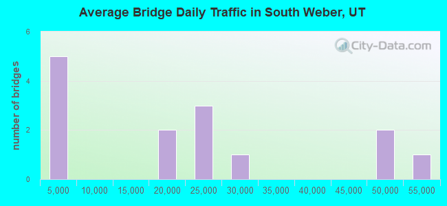
- 286,213Total average daily traffic
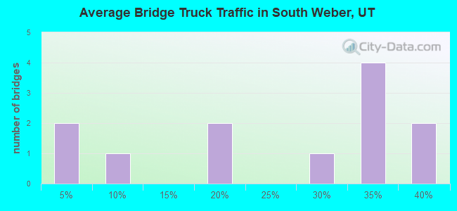
- 76,593Total average daily truck traffic
- National Bridge Inventory (NBI) Registered Bridges for South Weber
- No street view available for this location
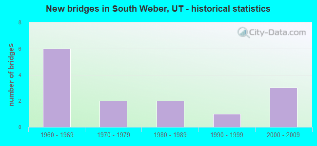
- New bridges - historical statistics
- 61960-1969
- 21970-1979
- 21980-1989
- 11990-1999
- 32000-2009
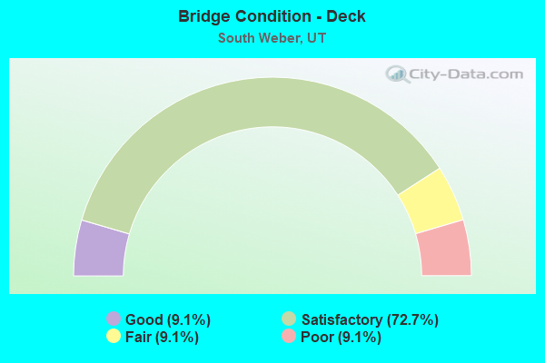
- Bridge Condition - Deck
- 9.1%Good
- 72.7%Satisfactory
- 9.1%Fair
- 9.1%Poor
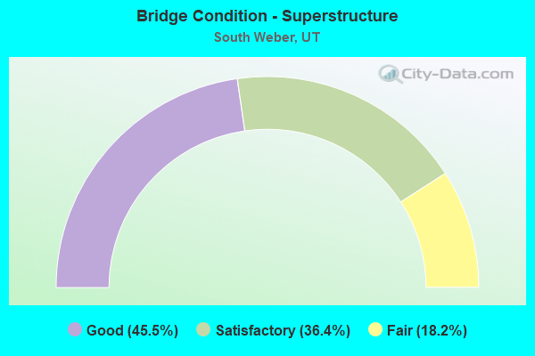
- Bridge Condition - Superstructure
- 45.5%Good
- 36.4%Satisfactory
- 18.2%Fair
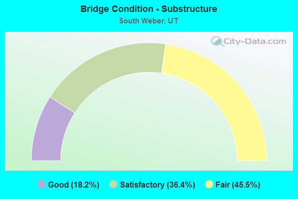
- Bridge Condition - Substructure
- 18.2%Good
- 36.4%Satisfactory
- 45.5%Fair
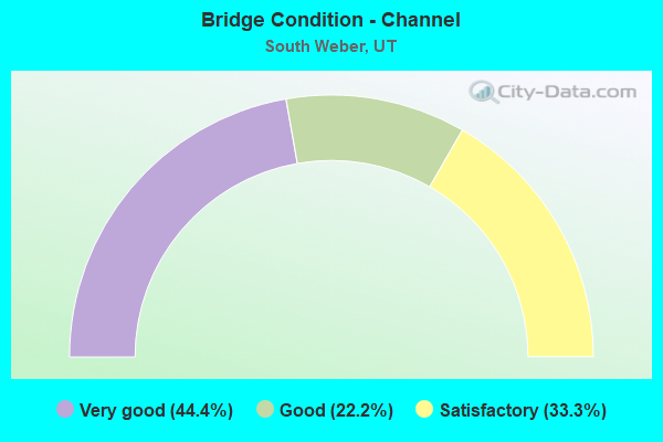
- Bridge Condition - Channel
- 44.4%Very good
- 22.2%Good
- 33.3%Satisfactory
Find on map >> Show street view
Structure Number: 11015F, Location: SE AREA OF SO.WEBER CITY (Lat: 41.121253, Lng: -111.915314), Route carried "on" structure: City street , Year Built: 1989, Status: Open, Structure Length: 1.77m (5.81ft), Average Daily Traffic: 1,260 (year 2020), Truck Traffic: 1%, Average Future Daily Traffic: 1,531 (year 2040), Design Load: HL 93, Features Intersected: WEBER-DAVIS CANAL, Facility Carried by Structure: PEACHWOOD DRIVE
Minimum Vertical Clearance: 30+ m (98+ ft), Kilometerpoint: 0.118, Lanes on structure: 2, Owner: City or Municipal Highway Agency, Approaching Roadway Width: 12.2m (40.0ft), Material/Design: Prestressed concrete, Design/Construction: Tee Beam, Number Of Spans In Main Unit: 1, Length of Maximum Span: 17.1m (56.1ft), Curb or Sidewalk Widths: Left: 0.0m, Right: 1.8m (5.9ft), Curb-To-Curb Width: 12.2m (40.0ft), Out-to-Out Width: 14.5m (47.6ft)
Condition: Deck: Satisfactory, Superstructure: Good, Substructure: Good, Channel: Good, Operating Rating: 32.4 metric tons, Method Used To Determine Operating Rating: Load and Resistance Factor Rating (LRFR) rating reported by rating factor(RF) method using HL-93 loadings, Inventory Rating: 21.7 metric tons, Method Used To Determine Inventory Rating: Load and Resistance Factor Rating (LRFR) rating reported by rating factor(RF) method using HL-93 loadings, Structural Evaluation: Somewhat better than minimum adequacy, Deck Geometry: Better than present minimum criteria, Waterway Adequacy: Equal to present minimum criteria, Approach Roadway Alignment: Equal to present desirable criteria, Designated Inspection Frequency: Every 24 months, Inspection Date: April 2020, Deck Structure Type: Concrete Precast Panels, Wearing Surface/Protective System: Wearing Surface: Bituminous
Find on map >> Show street view
Structure Number: 11022D, Location: 7920 S.1900 E., SO.WEBER (Lat: 41.123006, Lng: -111.929894), Route carried "on" structure: City street , Year Built: 1997, Status: Open, Structure Length: 0.94m (3.08ft), Average Daily Traffic: 630 (year 2020), Truck Traffic: 1%, Average Future Daily Traffic: 765 (year 2040), Design Load: HS 20+Mod, Features Intersected: WEBER-DAVIS CANAL, Facility Carried by Structure: 1900 EAST STREET
Minimum Vertical Clearance: 30+ m (98+ ft), Kilometerpoint: 0.122, Lanes on structure: 2, Owner: City or Municipal Highway Agency, Approaching Roadway Width: 12.2m (40.0ft), Material/Design: Concrete, Design/Construction: Frame, Number Of Spans In Main Unit: 1, Length of Maximum Span: 8.8m (28.9ft), Curb or Sidewalk Widths: Left: 2.5m (8.2ft), Right: 2.9m (9.5ft), Curb-To-Curb Width: 18.6m (61.0ft), Out-to-Out Width: 20.3m (66.6ft)
Condition: Deck: Satisfactory, Superstructure: Satisfactory, Substructure: Satisfactory, Channel: Very good, Operating Rating: 32.4 metric tons, Method Used To Determine Operating Rating: Load and Resistance Factor Rating (LRFR) rating reported by rating factor(RF) method using HL-93 loadings, Inventory Rating: 21.1 metric tons, Method Used To Determine Inventory Rating: Load and Resistance Factor Rating (LRFR) rating reported by rating factor(RF) method using HL-93 loadings, Structural Evaluation: Somewhat better than minimum adequacy, Deck Geometry: Superior to present desirable criteria, Waterway Adequacy: Equal to present desirable criteria, Approach Roadway Alignment: Equal to present desirable criteria, Designated Inspection Frequency: Every 23 months, Inspection Date: April 2020, Deck Structure Type: Concrete Precast Panels, Wearing Surface/Protective System: Wearing Surface: Bituminous
Find on map >> Show street view
Structure Number: 57022C, Location: ON THE SO WEBER-UINTAH RD (Lat: 41.146994, Lng: -111.960017), Route carried "on" structure: City street 3342, Year Built: 1986, Status: Open, Structure Length: 4.07m (13.35ft), Average Daily Traffic: 96 (year 2020), Average Future Daily Traffic: 120 (year 2040), Design Load: HS 20+Mod, Features Intersected: WEBER RIVER, Facility Carried by Structure: UINTAH TOWN STREET
Minimum Vertical Clearance: 30+ m (98+ ft), Kilometerpoint: 0.922, Lanes on structure: 2, Owner: Town or Township Highway Agency, Approaching Roadway Width: 9.4m (30.8ft), Material/Design: Steel, Design/Construction: Stringer/Multi-beam, Number Of Spans In Main Unit: 1, Length of Maximum Span: 39.9m (130.9ft), Curb-To-Curb Width: 9.4m (30.8ft), Out-to-Out Width: 10.4m (34.1ft)
Condition: Deck: Satisfactory, Superstructure: Good, Substructure: Good, Channel: Satisfactory, Operating Rating: 42.4 metric tons, Method Used To Determine Operating Rating: Load and Resistance Factor Rating (LRFR) rating reported by rating factor(RF) method using HL-93 loadings, Inventory Rating: 36.0 metric tons, Method Used To Determine Inventory Rating: Load Factor (LF) rating reported by rating factor (RF) method using MS18 loading, Structural Evaluation: Better than present minimum criteria, Deck Geometry: Better than present minimum criteria, Waterway Adequacy: Equal to present minimum criteria, Approach Roadway Alignment: Equal to present desirable criteria, Designated Inspection Frequency: Every 24 months, Inspection Date: April 2020, Deck Structure Type: Concrete Cast-file-Place, Wearing Surface/Protective System: Wearing Surface: Bituminous
Find on map >> Show street view
Structure Number: C 644, Location: SOUTH WEBER INTERCHANGE (Lat: 41.149386, Lng: -111.968914), Route carried "on" structure: City street 1508, Year Built: 1974, Status: Open, Structure Length: 14.70m (48.23ft), Average Daily Traffic: 3,715 (year 2020), Average Future Daily Traffic: 4,644 (year 2040), Design Load: HS 20+Mod, Features Intersected: I-84 (SR-84) EBL & W, Facility Carried by Structure: 500 E.ST.-SO.WEBER
Minimum Vertical Clearance: 30+ m (98+ ft), Kilometerpoint: 1.077, Lanes on structure: 3, Lanes under structure: 6, Owner: State Highway Agency, Approaching Roadway Width: 17.2m (56.4ft), Skew: 23 degrees, Material/Design: Steel continuous, Design/Construction: Girder and Floorbeam System, Number Of Spans In Main Unit: 3, Length of Maximum Span: 55.3m (181.4ft), Curb-To-Curb Width: 17.2m (56.4ft), Out-to-Out Width: 18.3m (60.0ft)
Condition: Deck: Poor, Superstructure: Good, Substructure: Satisfactory, Operating Rating: 34.3 metric tons, Method Used To Determine Operating Rating: Load and Resistance Factor Rating (LRFR) rating reported by rating factor(RF) method using HL-93 loadings, Inventory Rating: 22.0 metric tons, Method Used To Determine Inventory Rating: Load and Resistance Factor Rating (LRFR) rating reported by rating factor(RF) method using HL-93 loadings, Structural Evaluation: Somewhat better than minimum adequacy, Deck Geometry: Superior to present desirable criteria, Underclear: Equal to present minimum criteria, Approach Roadway Alignment: Equal to present desirable criteria, Designated Inspection Frequency: Every 24 months, Inspection Date: August 2021, Deck Structure Type: Concrete Cast-file-Place, Wearing Surface/Protective System: Wearing Surface: Bituminous, Membrane: Preformed Fabric
Find on map >> Show street view
Structure Number: D 763, Location: POWER PLANT WEBER CANYON (Lat: 41.137711, Lng: -111.881544), Route carried "on" structure: Interstate 84, Year Built: 1964, Status: Open, Structure Length: 1.95m (6.40ft), Average Daily Traffic: 20,010 (year 2020), Truck Traffic: 37%, Average Future Daily Traffic: 25,013 (year 2040), Design Load: HS 20+Mod, Features Intersected: U.P.and L.CO.PENSTOCK
Minimum Vertical Clearance: 30+ m (98+ ft), Kilometerpoint: 144.122, Lanes on structure: 2, Base Highway Network: Yes, Owner: State Highway Agency, Approaching Roadway Width: 11.6m (38.1ft), Skew: 1 degrees, Material/Design: Concrete, Design/Construction: Frame, Number Of Spans In Main Unit: 1, Length of Maximum Span: 19.5m (64.0ft), Curb-To-Curb Width: 11.6m (38.1ft), Out-to-Out Width: 19.2m (63.0ft)
Condition: Deck: Satisfactory, Superstructure: Satisfactory, Substructure: Satisfactory, Operating Rating: 48.3 metric tons, Method Used To Determine Operating Rating: Load and Resistance Factor Rating (LRFR) rating reported by rating factor(RF) method using HL-93 loadings, Inventory Rating: 32.7 metric tons, Method Used To Determine Inventory Rating: Load and Resistance Factor Rating (LRFR) rating reported by rating factor(RF) method using HL-93 loadings, Structural Evaluation: Equal to present minimum criteria, Deck Geometry: Equal to present minimum criteria, Approach Roadway Alignment: Equal to present desirable criteria, Designated Inspection Frequency: Every 24 months, Inspection Date: July 2021
Find on map >> Show street view
Structure Number: E2462, Location: 1.1 MILE SO. UINTAH JCT. (Lat: 41.124669, Lng: -111.907947), Route carried "on" structure: US , Year Built: 2001, Status: Open, Structure Length: 1.12m (3.67ft), Average Daily Traffic: 45,615 (year 2020), Truck Traffic: 33%, Average Future Daily Traffic: 57,019 (year 2040), Design Load: HS 20+Mod, Features Intersected: WEBER-DAVIS CANAL, Facility Carried by Structure: US-89 (SR-89)
Minimum Vertical Clearance: 30+ m (98+ ft), Kilometerpoint: 0.033, Lanes on structure: 8, Base Highway Network: Yes, Owner: State Highway Agency, Approaching Roadway Width: 71.7m (235.2ft), Skew: 31 degrees, Material/Design: Concrete, Design/Construction: Culvert, Number Of Spans In Main Unit: 2, Length of Maximum Span: 5.1m (16.7ft)
Condition: Channel: Very good, Culverts: Satisfactory, Operating Rating: 32.4 metric tons, Method Used To Determine Operating Rating: Load and Resistance Factor Rating (LRFR) rating reported by rating factor(RF) method using HL-93 loadings, Inventory Rating: 19.8 metric tons, Method Used To Determine Inventory Rating: Load Factor (LF) rating reported by rating factor (RF) method using MS18 loading, Structural Evaluation: Somewhat better than minimum adequacy, Waterway Adequacy: Equal to present desirable criteria, Approach Roadway Alignment: Equal to present desirable criteria, Designated Inspection Frequency: Every 24 months, Inspection Date: June 2021
Find on map >> Show street view
Structure Number: F 671, Location: 1 Mi.So.I-80,US-89 Intchg (Lat: 41.128064, Lng: -111.908572), Route carried "on" structure: State highway 60, Year Built: 2001, Status: Open, Structure Length: 6.19m (20.31ft), Average Daily Traffic: 3,381 (year 2020), Truck Traffic: 5%, Average Future Daily Traffic: 4,226 (year 2040), Design Load: HS 20+Mod, Features Intersected: US-89, (SR-89)
Minimum Vertical Clearance: 30+ m (98+ ft), Kilometerpoint: 11.677, Lanes on structure: 2, Lanes under structure: 7, Owner: State Highway Agency, Approaching Roadway Width: 19.8m (65.0ft), Skew: 20 degrees, Material/Design: Prestressed concrete, Design/Construction: Stringer/Multi-beam, Number Of Spans In Main Unit: 2, Length of Maximum Span: 33.2m (108.9ft), Curb or Sidewalk Widths: Left: 3.0m (9.8ft), Right: 0.0m, Curb-To-Curb Width: 19.8m (65.0ft), Out-to-Out Width: 24.0m (78.7ft)
Condition: Deck: Satisfactory, Superstructure: Good, Substructure: Satisfactory, Operating Rating: 55.7 metric tons, Method Used To Determine Operating Rating: Load and Resistance Factor Rating (LRFR) rating reported by rating factor(RF) method using HL-93 loadings, Inventory Rating: 47.0 metric tons, Method Used To Determine Inventory Rating: Load Factor (LF) rating reported by rating factor (RF) method using MS18 loading, Structural Evaluation: Equal to present minimum criteria, Deck Geometry: Superior to present desirable criteria, Underclear: Somewhat better than minimum adequacy, Approach Roadway Alignment: Equal to present desirable criteria, Designated Inspection Frequency: Every 24 months, Inspection Date: June 2021, Deck Structure Type: Concrete Cast-file-Place, Wearing Surface/Protective System: Wearing Surface: Epoxy Overlay, Deck Protection: Epoxy Coated Reinforcing
Find on map >> Show street view
Structure Number: 1F 175, Location: 0.3 MI.SO.UINTAH JCT. (Lat: 41.134367, Lng: -111.911864), Route carried "on" structure: US , Year Built: 1967, Status: Open, Structure Length: 5.73m (18.80ft), Average Daily Traffic: 49,785 (year 2020), Truck Traffic: 31%, Average Future Daily Traffic: 62,232 (year 2040), Design Load: HS 20+Mod, Features Intersected: WEBER RIVER, Facility Carried by Structure: US-89 (SR-89) NBL
Minimum Vertical Clearance: 30+ m (98+ ft), Kilometerpoint: 0.225, Lanes on structure: 2, Base Highway Network: Yes, Owner: State Highway Agency, Approaching Roadway Width: 10.5m (34.4ft), Skew: 14 degrees, Material/Design: Prestressed concrete, Design/Construction: Stringer/Multi-beam, Number Of Spans In Main Unit: 3, Length of Maximum Span: 18.6m (61.0ft), Curb-To-Curb Width: 10.5m (34.4ft), Out-to-Out Width: 11.5m (37.7ft)
Condition: Deck: Satisfactory, Superstructure: Satisfactory, Substructure: Fair, Channel: Satisfactory, Operating Rating: 40.8 metric tons, Method Used To Determine Operating Rating: Load and Resistance Factor Rating (LRFR) rating reported by rating factor(RF) method using HL-93 loadings, Inventory Rating: 26.6 metric tons, Method Used To Determine Inventory Rating: Load and Resistance Factor Rating (LRFR) rating reported by rating factor(RF) method using HL-93 loadings, Structural Evaluation: Somewhat better than minimum adequacy, Deck Geometry: Somewhat better than minimum adequacy, Waterway Adequacy: Better than present minimum criteria, Approach Roadway Alignment: Equal to present desirable criteria, Designated Inspection Frequency: Every 24 months, Inspection Date: August 2021, Deck Structure Type: Concrete Cast-file-Place, Wearing Surface/Protective System: Wearing Surface: Bituminous, Membrane: Preformed Fabric
Find on map >> Show street view
Structure Number: 2C 477, Location: BY POWER PLANT WEBER CYN. (Lat: 41.137883, Lng: -111.886842), Route carried "on" structure: Interstate 84, Year Built: 1967, Year Reconstructed: 2008, Status: Open, Structure Length: 13.16m (43.18ft), Average Daily Traffic: 20,010 (year 2020), Truck Traffic: 37%, Average Future Daily Traffic: 25,013 (year 2040), Design Load: HS 20+Mod, Features Intersected: WEBER RIVER
Minimum Vertical Clearance: 30+ m (98+ ft), Kilometerpoint: 143.818, Lanes on structure: 2, Base Highway Network: Yes, Owner: State Highway Agency, Approaching Roadway Width: 10.1m (33.1ft), Skew: 7 degrees, Material/Design: Steel continuous, Design/Construction: Stringer/Multi-beam, Number Of Spans In Main Unit: 6, Length of Maximum Span: 26.5m (86.9ft), Curb-To-Curb Width: 10.1m (33.1ft), Out-to-Out Width: 10.4m (34.1ft)
Condition: Deck: Good, Superstructure: Fair, Substructure: Fair, Channel: Good, Operating Rating: 34.0 metric tons, Method Used To Determine Operating Rating: Load and Resistance Factor Rating (LRFR) rating reported by rating factor(RF) method using HL-93 loadings, Inventory Rating: 16.2 metric tons, Method Used To Determine Inventory Rating: Load and Resistance Factor Rating (LRFR) rating reported by rating factor(RF) method using HL-93 loadings, Structural Evaluation: Meets minimum limits, Deck Geometry: Meets minimum limits, Waterway Adequacy: Equal to present minimum criteria, Approach Roadway Alignment: Equal to present minimum criteria, Designated Inspection Frequency: Every 24 months, Inspection Date: July 2021, Deck Structure Type: Concrete Precast Panels, Wearing Surface/Protective System: Wearing Surface: Epoxy Overlay, Deck Protection: Epoxy Coated Reinforcing
Find on map >> Show street view
Structure Number: 2F 95, Location: .3 MI.WEST OF UINTAH JCT. (Lat: 41.136825, Lng: -111.919411), Route carried "on" structure: Interstate 84, Year Built: 1964, Status: Open, Structure Length: 3.61m (11.84ft), Average Daily Traffic: 19,408 (year 2020), Truck Traffic: 32%, Average Future Daily Traffic: 24,260 (year 2040), Design Load: HS 20+Mod, Features Intersected: WEBER RIVER
Minimum Vertical Clearance: 30+ m (98+ ft), Kilometerpoint: 141.032, Lanes on structure: 2, Base Highway Network: Yes, Owner: State Highway Agency, Approaching Roadway Width: 11.6m (38.1ft), Material/Design: Prestressed concrete, Design/Construction: Stringer/Multi-beam, Number Of Spans In Main Unit: 2, Length of Maximum Span: 17.3m (56.8ft), Curb-To-Curb Width: 11.6m (38.1ft), Out-to-Out Width: 12.5m (41.0ft)
Condition: Deck: Satisfactory, Superstructure: Good, Substructure: Fair, Channel: Very good, Operating Rating: 34.0 metric tons, Method Used To Determine Operating Rating: Load and Resistance Factor Rating (LRFR) rating reported by rating factor(RF) method using HL-93 loadings, Inventory Rating: 33.7 metric tons, Method Used To Determine Inventory Rating: Load and Resistance Factor Rating (LRFR) rating reported by rating factor(RF) method using HL-93 loadings, Structural Evaluation: Somewhat better than minimum adequacy, Deck Geometry: Equal to present minimum criteria, Waterway Adequacy: Equal to present desirable criteria, Approach Roadway Alignment: Equal to present desirable criteria, Designated Inspection Frequency: Every 24 months, Inspection Date: August 2021, Deck Structure Type: Concrete Cast-file-Place, Wearing Surface/Protective System: Wearing Surface: Epoxy Overlay
Find on map >> Show street view
Structure Number: 3F 175, Location: 0.3 MI.SO.UINTAH JCT. (Lat: 41.134908, Lng: -111.912433), Route carried "on" structure: US , Year Built: 1967, Status: Open, Structure Length: 5.73m (18.80ft), Average Daily Traffic: 29,870 (year 2020), Truck Traffic: 16%, Average Future Daily Traffic: 37,338 (year 2040), Design Load: HS 20+Mod, Features Intersected: WEBER RIVER, Facility Carried by Structure: US-89 (SR-89) SBL
Minimum Vertical Clearance: 30+ m (98+ ft), Kilometerpoint: 0.025, Lanes on structure: 2, Base Highway Network: Yes, Owner: State Highway Agency, Approaching Roadway Width: 10.5m (34.4ft), Skew: 14 degrees, Material/Design: Prestressed concrete, Design/Construction: Stringer/Multi-beam, Number Of Spans In Main Unit: 3, Length of Maximum Span: 18.6m (61.0ft), Curb-To-Curb Width: 10.5m (34.4ft), Out-to-Out Width: 11.5m (37.7ft)
Condition: Deck: Fair, Superstructure: Fair, Substructure: Fair, Channel: Satisfactory, Operating Rating: 40.8 metric tons, Method Used To Determine Operating Rating: Load and Resistance Factor Rating (LRFR) rating reported by rating factor(RF) method using HL-93 loadings, Inventory Rating: 26.6 metric tons, Method Used To Determine Inventory Rating: Load and Resistance Factor Rating (LRFR) rating reported by rating factor(RF) method using HL-93 loadings, Structural Evaluation: Somewhat better than minimum adequacy, Deck Geometry: Somewhat better than minimum adequacy, Waterway Adequacy: Better than present minimum criteria, Approach Roadway Alignment: Equal to present desirable criteria, Designated Inspection Frequency: Every 24 months, Inspection Date: August 2021, Deck Structure Type: Concrete Cast-file-Place, Wearing Surface/Protective System: Wearing Surface: Bituminous
Find on map >> Show street view
Structure Number: 4F 95, Location: .3 MI.WEST OF UINTAH JCT. (Lat: 41.137033, Lng: -111.919000), Route carried "on" structure: Interstate 84, Year Built: 1964, Status: Open, Structure Length: 3.61m (11.84ft), Average Daily Traffic: 19,408 (year 2020), Truck Traffic: 32%, Average Future Daily Traffic: 24,260 (year 2040), Design Load: HS 20+Mod, Features Intersected: WEBER RIVER
Minimum Vertical Clearance: 30+ m (98+ ft), Kilometerpoint: 140.927, Lanes on structure: 2, Base Highway Network: Yes, Owner: State Highway Agency, Approaching Roadway Width: 11.6m (38.1ft), Material/Design: Prestressed concrete, Design/Construction: Stringer/Multi-beam, Number Of Spans In Main Unit: 2, Length of Maximum Span: 17.3m (56.8ft), Curb-To-Curb Width: 11.6m (38.1ft), Out-to-Out Width: 12.5m (41.0ft)
Condition: Deck: Satisfactory, Superstructure: Satisfactory, Substructure: Fair, Channel: Very good, Operating Rating: 34.0 metric tons, Method Used To Determine Operating Rating: Load and Resistance Factor Rating (LRFR) rating reported by rating factor(RF) method using HL-93 loadings, Inventory Rating: 33.7 metric tons, Method Used To Determine Inventory Rating: Load and Resistance Factor Rating (LRFR) rating reported by rating factor(RF) method using HL-93 loadings, Structural Evaluation: Somewhat better than minimum adequacy, Deck Geometry: Equal to present minimum criteria, Waterway Adequacy: Equal to present desirable criteria, Approach Roadway Alignment: Equal to present desirable criteria, Designated Inspection Frequency: Every 24 months, Inspection Date: August 2021, Deck Structure Type: Concrete Cast-file-Place, Wearing Surface/Protective System: Wearing Surface: Epoxy Overlay
Find on map >> Show street view
Structure Number: C 644, Location: SOUTH WEBER INTERCHANGE (Lat: 41.149386, Lng: -111.968914), Route carried "under" structure: Interstate 84, Year Built: 1974, Structure Length: 0. m, Average Daily Traffic: 20,299 (year 2020), Truck Traffic: 27%, Features Intersected: I-84 (SR-84) EBL & W, Facility Carried by Structure: 500 E.ST.-SO.WEBER
Minimum Vertical Clearance: 5.05m (16.57ft), Kilometerpoint: 136.141, Lanes on structure: 3, Lanes under structure: 6, Material/Design: Steel continuous, Design/Construction: Girder and Floorbeam System, Length of Maximum Span: 55.3m (181.4ft)
Find on map >> Show street view
Structure Number: F 671, Location: 1 Mi.So.I-80,US-89 Intchg (Lat: 41.128064, Lng: -111.908572), Route carried "under" structure: US 89, Year Built: 2001, Structure Length: 0. m, Average Daily Traffic: 52,726 (year 2020), Truck Traffic: 16%, Features Intersected: US-89, (SR-89), Facility Carried by Structure: SR-60,SO.WEBER DR.
Minimum Vertical Clearance: 5.21m (17.09ft), Kilometerpoint: 652.958, Lanes on structure: 2, Lanes under structure: 7, Material/Design: Prestressed concrete, Design/Construction: Stringer/Multi-beam, Length of Maximum Span: 33.2m (108.9ft)