Bridge Statistics for South Sioux City, Nebraska (NE)
Condition, Traffic, Stress, Structural Evaluation, Project Costs
- National Bridge Inventory (NBI) Statistics
- 21Number of bridges
- 479ft / 146mTotal length
- 240,080Total average daily traffic
- 23,118Total average daily truck traffic
- National Bridge Inventory (NBI) Registered Bridges for South Sioux City
- No street view available for this location
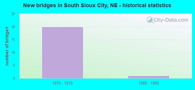
- New bridges - historical statistics
- 201970-1979
- 11980-1989
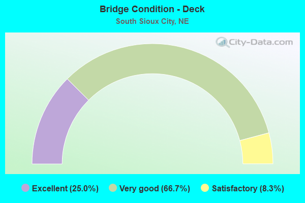
- Bridge Condition - Deck
- 25.0%Excellent
- 66.7%Very good
- 8.3%Satisfactory
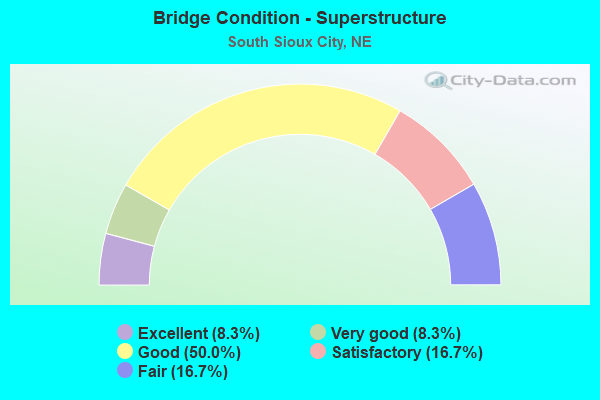
- Bridge Condition - Superstructure
- 8.3%Excellent
- 8.3%Very good
- 50.0%Good
- 16.7%Satisfactory
- 16.7%Fair
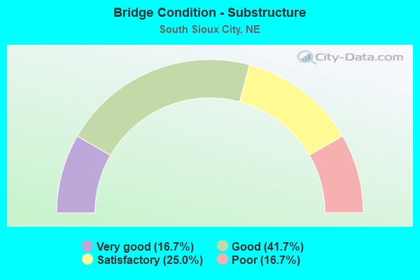
- Bridge Condition - Substructure
- 16.7%Very good
- 41.7%Good
- 25.0%Satisfactory
- 16.7%Poor
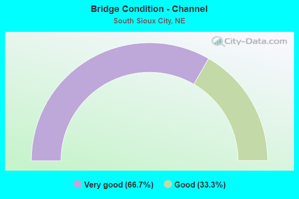
- Bridge Condition - Channel
- 66.7%Very good
- 33.3%Good
Find on map >> Show street view
Structure Number: S077 1887, Location: NCL SOUTH SIOUX CITY (Lat: 42.488000, Lng: -96.413600), Route carried "on" structure: US 77, Year Built: 1981, Year Reconstructed: 1983, Status: Open, Structure Length: 45.78m (150.20ft), Average Daily Traffic: 32,065 (year 2018), Truck Traffic: 2%, Average Future Daily Traffic: 43,159 (year 2038), Design Load: HS 20, Features Intersected: MISSOURI RIVER
Minimum Vertical Clearance: 5.33m (17.49ft), Kilometerpoint: 30.368, Lanes on structure: 4, Lanes under structure: 2, Base Highway Network: Yes, Owner: State Highway Agency, Approaching Roadway Width: 19.2m (63.0ft), Skew: 30 degrees, Navigation Control: Yes ( Vertical Clearance: 158.0m (518.4ft), Horizontal Clearance: 1219.0m (3,999.3ft)), Material/Design: Steel, Design/Construction: Arch - Thru, Number Of Spans In Main Unit: 1, Number Of Approach Spans: 7, Length of Maximum Span: 129.5m (424.9ft), Curb or Sidewalk Widths: Left: 0.0m, Right: 2.4m (7.9ft), Curb-To-Curb Width: 19.2m (63.0ft), Out-to-Out Width: 20.6m (67.6ft)
Condition: Deck: Satisfactory, Superstructure: Satisfactory, Substructure: Satisfactory, Channel: Good, Operating Rating: 44.0 metric tons, Method Used To Determine Operating Rating: Field evaluation and documented engineering judgment, Inventory Rating: 33.0 metric tons, Method Used To Determine Inventory Rating: Field evaluation and documented engineering judgment, Structural Evaluation: Equal to present minimum criteria, Deck Geometry: Somewhat better than minimum adequacy, Underclear: Superior to present desirable criteria, Waterway Adequacy: Equal to present desirable criteria, Approach Roadway Alignment: Equal to present desirable criteria, Designated Inspection Frequency: Every 24 months, Critical Feature Inspection Frequency: Every 24 months, Underwater Inspection Frequency: Every 60 months, Inspection Date: August 2020, Critical Feature Inspection Date: August 2020, Underwater Inspection Date: September 2019, Deck Structure Type: Concrete Cast-file-Place, Wearing Surface/Protective System: Wearing Surface: Monolithic Concrete, Deck Protection: Epoxy Coated Reinforcing
Find on map >> Show street view
Structure Number: S129 00008L, Location: I129/US77 INTERCHG 1W (Lat: 42.449300, Lng: -96.441900), Route carried "on" structure: Interstate 129, Year Built: 1977, Year Reconstructed: 2021, Status: Open, Structure Length: 3.05m (10.01ft), Average Daily Traffic: 8,090 (year 2018), Truck Traffic: 18%, Average Future Daily Traffic: 8,899 (year 2038), Features Intersected: LAKE AVENUE
Minimum Vertical Clearance: 30+ m (98+ ft), Kilometerpoint: 0.013, Lanes on structure: 2, Lanes under structure: 2, Base Highway Network: Yes, Owner: State Highway Agency, Approaching Roadway Width: 11.6m (38.1ft), Material/Design: Concrete continuous, Design/Construction: Slab, Number Of Spans In Main Unit: 3, Length of Maximum Span: 15.5m (50.9ft), Curb-To-Curb Width: 14.2m (46.6ft), Out-to-Out Width: 15.3m (50.2ft)
Condition: Deck: Very good, Superstructure: Very good, Substructure: Very good, Operating Rating: 48.0 metric tons, Method Used To Determine Operating Rating: Load Factor (LF), Inventory Rating: 28.0 metric tons, Method Used To Determine Inventory Rating: Load Factor (LF), Structural Evaluation: Better than present minimum criteria, Deck Geometry: Superior to present desirable criteria, Underclear: Meets minimum limits, Approach Roadway Alignment: Equal to present desirable criteria, Designated Inspection Frequency: Every 24 months, Inspection Date: September 2020, Deck Structure Type: Concrete Cast-file-Place, Wearing Surface/Protective System: Wearing Surface: Bituminous, Membrane: Built-up
Find on map >> Show street view
Structure Number: S129 00008R, Location: I129/US77 INTERCHG 1W (Lat: 42.449000, Lng: -96.441900), Route carried "on" structure: Interstate 129, Year Built: 1977, Year Reconstructed: 2021, Status: Open, Structure Length: 3.05m (10.01ft), Average Daily Traffic: 8,090 (year 2018), Truck Traffic: 18%, Average Future Daily Traffic: 8,899 (year 2038), Features Intersected: LAKE AVENUE
Minimum Vertical Clearance: 30+ m (98+ ft), Kilometerpoint: 0.013, Lanes on structure: 2, Lanes under structure: 2, Base Highway Network: Yes, Owner: State Highway Agency, Approaching Roadway Width: 11.6m (38.1ft), Material/Design: Concrete continuous, Design/Construction: Slab, Number Of Spans In Main Unit: 3, Length of Maximum Span: 15.5m (50.9ft), Curb-To-Curb Width: 13.8m (45.3ft), Out-to-Out Width: 14.9m (48.9ft)
Condition: Deck: Excellent, Superstructure: Excellent, Substructure: Very good, Operating Rating: 48.0 metric tons, Method Used To Determine Operating Rating: Load Factor (LF), Inventory Rating: 29.0 metric tons, Method Used To Determine Inventory Rating: Load Factor (LF), Structural Evaluation: Better than present minimum criteria, Deck Geometry: Superior to present desirable criteria, Underclear: Equal to present minimum criteria, Approach Roadway Alignment: Equal to present desirable criteria, Designated Inspection Frequency: Every 24 months, Inspection Date: September 2020, Deck Structure Type: Concrete Cast-file-Place, Wearing Surface/Protective System: Wearing Surface: Bituminous, Membrane: Built-up
Find on map >> Show street view
Structure Number: S129 00038, Location: I129/US77 INTERCHG (Lat: 42.449200, Lng: -96.436100), Route carried "on" structure: US 77, Year Built: 1977, Year Reconstructed: 2021, Status: Open, Structure Length: 7.50m (24.61ft), Average Daily Traffic: 1,575 (year 2018), Truck Traffic: 14%, Average Future Daily Traffic: 2,126 (year 2038), Features Intersected: I129
Minimum Vertical Clearance: 30+ m (98+ ft), Kilometerpoint: 0.060, Lanes on structure: 2, Lanes under structure: 4, Base Highway Network: Yes, Owner: State Highway Agency, Approaching Roadway Width: 11.6m (38.1ft), Skew: 1 degrees, Material/Design: Steel continuous, Design/Construction: Stringer/Multi-beam, Number Of Spans In Main Unit: 2, Length of Maximum Span: 37.2m (122.0ft), Curb-To-Curb Width: 15.1m (49.5ft), Out-to-Out Width: 15.8m (51.8ft)
Condition: Deck: Very good, Superstructure: Good, Substructure: Good, Operating Rating: 56.0 metric tons, Method Used To Determine Operating Rating: Load Factor (LF), Inventory Rating: 34.0 metric tons, Method Used To Determine Inventory Rating: Load Factor (LF), Structural Evaluation: Better than present minimum criteria, Deck Geometry: Superior to present desirable criteria, Underclear: Better than present minimum criteria, Approach Roadway Alignment: Equal to present desirable criteria, Designated Inspection Frequency: Every 24 months, Inspection Date: September 2020, Deck Structure Type: Concrete Cast-file-Place, Wearing Surface/Protective System: Wearing Surface: Bituminous, Membrane: Built-up
Find on map >> Show street view
Structure Number: S129 00039, Location: I129/US77 INTERCHG (Lat: 42.449000, Lng: -96.435800), Route carried "on" structure: US 77, Year Built: 1977, Year Reconstructed: 2021, Status: Open, Structure Length: 7.50m (24.61ft), Average Daily Traffic: 14,555 (year 2016), Truck Traffic: 4%, Average Future Daily Traffic: 27,858 (year 2036), Features Intersected: I129
Minimum Vertical Clearance: 30+ m (98+ ft), Kilometerpoint: 29.863, Lanes on structure: 2, Lanes under structure: 4, Base Highway Network: Yes, Owner: State Highway Agency, Approaching Roadway Width: 11.6m (38.1ft), Skew: 1 degrees, Material/Design: Steel continuous, Design/Construction: Stringer/Multi-beam, Number Of Spans In Main Unit: 2, Length of Maximum Span: 37.2m (122.0ft), Curb-To-Curb Width: 15.1m (49.5ft), Out-to-Out Width: 15.4m (50.5ft)
Condition: Deck: Excellent, Superstructure: Good, Substructure: Satisfactory, Operating Rating: 45.0 metric tons, Method Used To Determine Operating Rating: Load Factor (LF), Inventory Rating: 27.0 metric tons, Method Used To Determine Inventory Rating: Load Factor (LF), Structural Evaluation: Equal to present minimum criteria, Deck Geometry: Superior to present desirable criteria, Underclear: Equal to present minimum criteria, Approach Roadway Alignment: Equal to present desirable criteria, Length Of Structure Improvement: 7.50m (24.61ft), Designated Inspection Frequency: Every 24 months, Inspection Date: September 2020, Deck Structure Type: Other, Wearing Surface/Protective System: Wearing Surface: Bituminous, Membrane: Built-up
Find on map >> Show street view
Structure Number: S129 00107L, Location: I129/US77 INTERCHG 1E (Lat: 42.449436, Lng: -96.422511), Route carried "on" structure: Interstate 129, Year Built: 1977, Year Reconstructed: 2021, Status: Open, Structure Length: 21.12m (69.29ft), Average Daily Traffic: 14,995 (year 2018), Truck Traffic: 13%, Average Future Daily Traffic: 17,994 (year 2038), Features Intersected: CRYSTAL LAKE
Minimum Vertical Clearance: 30+ m (98+ ft), Kilometerpoint: 0.172, Lanes on structure: 2, Base Highway Network: Yes, Owner: State Highway Agency, Approaching Roadway Width: 11.6m (38.1ft), Material/Design: Prestressed concrete, Design/Construction: Stringer/Multi-beam, Number Of Spans In Main Unit: 10, Number Of Approach Spans: 2, Length of Maximum Span: 21.0m (68.9ft), Curb-To-Curb Width: 12.1m (39.7ft), Out-to-Out Width: 13.3m (43.6ft)
Condition: Deck: Very good, Superstructure: Fair, Substructure: Poor, Channel: Very good, Operating Rating: 63.0 metric tons, Method Used To Determine Operating Rating: Load Factor (LF), Inventory Rating: 32.0 metric tons, Method Used To Determine Inventory Rating: Load Factor (LF), Structural Evaluation: Meets minimum limits, Deck Geometry: Equal to present minimum criteria, Waterway Adequacy: Equal to present desirable criteria, Approach Roadway Alignment: Equal to present desirable criteria, Designated Inspection Frequency: Every 24 months, Inspection Date: September 2020, Deck Structure Type: Concrete Cast-file-Place, Wearing Surface/Protective System: Wearing Surface: Bituminous, Membrane: Built-up
Find on map >> Show street view
Structure Number: S129 00107R, Location: I129/US77 INTERCHG 1E (Lat: 42.449100, Lng: -96.423000), Route carried "on" structure: Interstate 129, Year Built: 1977, Year Reconstructed: 2021, Status: Open, Structure Length: 21.12m (69.29ft), Average Daily Traffic: 14,995 (year 2018), Truck Traffic: 13%, Average Future Daily Traffic: 17,994 (year 2038), Features Intersected: CRYSTAL LAKE
Minimum Vertical Clearance: 30+ m (98+ ft), Kilometerpoint: 0.172, Lanes on structure: 2, Base Highway Network: Yes, Owner: State Highway Agency, Approaching Roadway Width: 11.6m (38.1ft), Material/Design: Prestressed concrete, Design/Construction: Stringer/Multi-beam, Number Of Spans In Main Unit: 10, Number Of Approach Spans: 2, Length of Maximum Span: 21.0m (68.9ft), Curb-To-Curb Width: 12.0m (39.4ft), Out-to-Out Width: 12.9m (42.3ft)
Condition: Deck: Very good, Superstructure: Fair, Substructure: Poor, Channel: Very good, Operating Rating: 63.0 metric tons, Method Used To Determine Operating Rating: Load Factor (LF), Inventory Rating: 32.0 metric tons, Method Used To Determine Inventory Rating: Load Factor (LF), Structural Evaluation: Meets minimum limits, Deck Geometry: Equal to present minimum criteria, Waterway Adequacy: Equal to present desirable criteria, Approach Roadway Alignment: Equal to present desirable criteria, Length Of Structure Improvement: 21.12m (69.29ft), Designated Inspection Frequency: Every 24 months, Inspection Date: September 2020, Deck Structure Type: Concrete Cast-file-Place, Wearing Surface/Protective System: Wearing Surface: Bituminous, Membrane: Built-up
Find on map >> Show street view
Structure Number: S129 00123L, Location: DAKOTA AVE/I129 INTRCH 1W (Lat: 42.449400, Lng: -96.419200), Route carried "on" structure: Interstate 129, Year Built: 1977, Year Reconstructed: 2021, Status: Open, Structure Length: 10.15m (33.30ft), Average Daily Traffic: 14,995 (year 2018), Truck Traffic: 13%, Average Future Daily Traffic: 17,994 (year 2038), Features Intersected: BNSF/UPRR/5TH
Minimum Vertical Clearance: 30+ m (98+ ft), Kilometerpoint: 0.198, Lanes on structure: 2, Lanes under structure: 2, Base Highway Network: Yes, Owner: State Highway Agency, Approaching Roadway Width: 11.6m (38.1ft), Material/Design: Steel continuous, Design/Construction: Stringer/Multi-beam, Number Of Spans In Main Unit: 3, Length of Maximum Span: 37.5m (123.0ft), Curb-To-Curb Width: 14.8m (48.6ft), Out-to-Out Width: 15.5m (50.9ft)
Condition: Deck: Very good, Superstructure: Good, Substructure: Good, Operating Rating: 59.0 metric tons, Method Used To Determine Operating Rating: Load Factor (LF), Inventory Rating: 35.0 metric tons, Method Used To Determine Inventory Rating: Load Factor (LF), Structural Evaluation: Better than present minimum criteria, Deck Geometry: Superior to present desirable criteria, Underclear: Equal to present minimum criteria, Approach Roadway Alignment: Equal to present desirable criteria, Designated Inspection Frequency: Every 24 months, Inspection Date: September 2020, Deck Structure Type: Concrete Cast-file-Place, Wearing Surface/Protective System: Wearing Surface: Bituminous, Membrane: Built-up
Find on map >> Show street view
Structure Number: S129 00123R, Location: DAKOTA AVE/I129 INTRCH 1W (Lat: 42.449200, Lng: -96.419200), Route carried "on" structure: Interstate 129, Year Built: 1977, Year Reconstructed: 2021, Status: Open, Structure Length: 10.15m (33.30ft), Average Daily Traffic: 14,995 (year 2018), Truck Traffic: 13%, Average Future Daily Traffic: 17,994 (year 2038), Features Intersected: BNSF/UPRR/5TH
Minimum Vertical Clearance: 30+ m (98+ ft), Kilometerpoint: 0.198, Lanes on structure: 2, Lanes under structure: 2, Base Highway Network: Yes, Owner: State Highway Agency, Approaching Roadway Width: 11.6m (38.1ft), Material/Design: Steel continuous, Design/Construction: Stringer/Multi-beam, Number Of Spans In Main Unit: 3, Length of Maximum Span: 37.5m (123.0ft), Curb-To-Curb Width: 14.1m (46.3ft), Out-to-Out Width: 14.9m (48.9ft)
Condition: Deck: Very good, Superstructure: Good, Substructure: Good, Operating Rating: 59.0 metric tons, Method Used To Determine Operating Rating: Load Factor (LF), Inventory Rating: 35.0 metric tons, Method Used To Determine Inventory Rating: Load Factor (LF), Structural Evaluation: Better than present minimum criteria, Deck Geometry: Superior to present desirable criteria, Underclear: Better than present minimum criteria, Approach Roadway Alignment: Equal to present desirable criteria, Designated Inspection Frequency: Every 24 months, Inspection Date: September 2020, Deck Structure Type: Concrete Cast-file-Place, Wearing Surface/Protective System: Wearing Surface: Bituminous, Membrane: Built-up
Find on map >> Show street view
Structure Number: S129 00150L, Location: DAKOTA AVE/I129 INTRCHG (Lat: 42.449500, Lng: -96.414000), Route carried "on" structure: Interstate 129, Year Built: 1974, Year Reconstructed: 2021, Status: Open, Structure Length: 5.46m (17.91ft), Average Daily Traffic: 14,995 (year 2018), Truck Traffic: 13%, Average Future Daily Traffic: 17,994 (year 2038), Features Intersected: DAKOTA AVE
Minimum Vertical Clearance: 30+ m (98+ ft), Kilometerpoint: 0.241, Lanes on structure: 2, Lanes under structure: 4, Base Highway Network: Yes, Owner: State Highway Agency, Approaching Roadway Width: 11.6m (38.1ft), Material/Design: Steel continuous, Design/Construction: Stringer/Multi-beam, Number Of Spans In Main Unit: 2, Length of Maximum Span: 29.0m (95.1ft), Curb-To-Curb Width: 12.0m (39.4ft), Out-to-Out Width: 12.8m (42.0ft)
Condition: Deck: Very good, Superstructure: Good, Substructure: Satisfactory, Operating Rating: 66.0 metric tons, Method Used To Determine Operating Rating: Load Factor (LF), Inventory Rating: 40.0 metric tons, Method Used To Determine Inventory Rating: Load Factor (LF), Structural Evaluation: Equal to present minimum criteria, Deck Geometry: Equal to present minimum criteria, Underclear: Better than present minimum criteria, Approach Roadway Alignment: Equal to present desirable criteria, Designated Inspection Frequency: Every 48 months, Inspection Date: September 2020, Deck Structure Type: Concrete Cast-file-Place, Wearing Surface/Protective System: Wearing Surface: Bituminous, Membrane: Built-up
Find on map >> Show street view
Structure Number: S129 00150R, Location: DAKOTA AVE/I129 INTRCHG (Lat: 42.449200, Lng: -96.414000), Route carried "on" structure: Interstate 129, Year Built: 1975, Year Reconstructed: 2021, Status: Open, Structure Length: 5.46m (17.91ft), Average Daily Traffic: 14,995 (year 2018), Truck Traffic: 13%, Average Future Daily Traffic: 17,994 (year 2038), Features Intersected: DAKOTA AVE
Minimum Vertical Clearance: 30+ m (98+ ft), Kilometerpoint: 0.241, Lanes on structure: 2, Lanes under structure: 4, Base Highway Network: Yes, Owner: State Highway Agency, Approaching Roadway Width: 11.6m (38.1ft), Material/Design: Steel continuous, Design/Construction: Stringer/Multi-beam, Number Of Spans In Main Unit: 2, Length of Maximum Span: 29.0m (95.1ft), Curb-To-Curb Width: 15.1m (49.5ft), Out-to-Out Width: 15.8m (51.8ft)
Condition: Deck: Very good, Superstructure: Good, Substructure: Good, Operating Rating: 66.0 metric tons, Method Used To Determine Operating Rating: Load Factor (LF), Inventory Rating: 40.0 metric tons, Method Used To Determine Inventory Rating: Load Factor (LF), Structural Evaluation: Better than present minimum criteria, Deck Geometry: Superior to present desirable criteria, Underclear: Meets minimum limits, Approach Roadway Alignment: Equal to present desirable criteria, Designated Inspection Frequency: Every 24 months, Inspection Date: September 2020, Deck Structure Type: Concrete Cast-file-Place, Wearing Surface/Protective System: Wearing Surface: Bituminous, Membrane: Built-up
Find on map >> Show street view
Structure Number: S129 00201, Location: DAKOTA AVE/I129 INTRCH 1E (Lat: 42.449400, Lng: -96.404100), Route carried "on" structure: County highway 235, Year Built: 1975, Year Reconstructed: 2021, Status: Open, Structure Length: 6.04m (19.82ft), Average Daily Traffic: 100 (year 2003), Truck Traffic: 10%, Average Future Daily Traffic: 145 (year 2033), Features Intersected: I129/US75, Facility Carried by Structure: G ST
Minimum Vertical Clearance: 30+ m (98+ ft), Kilometerpoint: 0.000, Lanes on structure: 2, Lanes under structure: 4, Owner: State Highway Agency, Approaching Roadway Width: 8.5m (27.9ft), Material/Design: Steel continuous, Design/Construction: Stringer/Multi-beam, Number Of Spans In Main Unit: 2, Length of Maximum Span: 30.2m (99.1ft), Curb or Sidewalk Widths: Left: 0.2m (0.7ft), Right: 0.2m (0.7ft), Curb-To-Curb Width: 8.5m (27.9ft), Out-to-Out Width: 9.3m (30.5ft)
Condition: Deck: Excellent, Superstructure: Satisfactory, Substructure: Good, Operating Rating: 52.0 metric tons, Method Used To Determine Operating Rating: Load Factor (LF), Inventory Rating: 31.0 metric tons, Method Used To Determine Inventory Rating: Load Factor (LF), Structural Evaluation: Equal to present minimum criteria, Deck Geometry: Better than present minimum criteria, Underclear: Somewhat better than minimum adequacy, Approach Roadway Alignment: Equal to present desirable criteria, Designated Inspection Frequency: Every 24 months, Inspection Date: September 2020, Deck Structure Type: Concrete Cast-file-Place, Wearing Surface/Protective System: Wearing Surface: Bituminous, Membrane: Built-up
Find on map >> Show street view
Structure Number: S129 00008L, Location: I129/US77 INTERCHG 1W (Lat: 42.449300, Lng: -96.441900), Route carried "under" structure: County highway 5300, Year Built: 1977, Structure Length: 0. m, Average Daily Traffic: 925 (year 2003), Features Intersected: LAKE AVENUE, Facility Carried by Structure: I129
Minimum Vertical Clearance: 4.54m (14.90ft), Kilometerpoint: 0.002, Lanes on structure: 2, Lanes under structure: 2, Material/Design: Concrete continuous, Design/Construction: Slab, Length of Maximum Span: 15.5m (50.9ft)
Find on map >> Show street view
Structure Number: S129 00008R, Location: I129/US77 INTERCHG 1W (Lat: 42.449000, Lng: -96.441900), Route carried "under" structure: County highway 5300, Year Built: 1977, Structure Length: 0. m, Average Daily Traffic: 925 (year 2003), Features Intersected: LAKE AVENUE, Facility Carried by Structure: I129
Minimum Vertical Clearance: 4.52m (14.83ft), Kilometerpoint: 0.003, Lanes on structure: 2, Lanes under structure: 2, Material/Design: Concrete continuous, Design/Construction: Slab, Length of Maximum Span: 15.5m (50.9ft)
Find on map >> Show street view
Structure Number: S129 00038, Location: I129/US77 INTERCHG (Lat: 42.449200, Lng: -96.436100), Route carried "under" structure: Interstate 129, Year Built: 1977, Structure Length: 0. m, Average Daily Traffic: 16,000 (year 2013), Truck Traffic: 13%, Features Intersected: I129, Facility Carried by Structure: SB-US77
Minimum Vertical Clearance: 5.12m (16.80ft), Kilometerpoint: 0.061, Lanes on structure: 4, Lanes under structure: 4, Material/Design: Steel continuous, Design/Construction: Stringer/Multi-beam, Length of Maximum Span: 37.2m (122.0ft)
Find on map >> Show street view
Structure Number: S129 00039, Location: I129/US77 INTERCHG (Lat: 42.449000, Lng: -96.435800), Route carried "under" structure: Interstate 129, Year Built: 1977, Structure Length: 0. m, Average Daily Traffic: 16,000 (year 2013), Truck Traffic: 13%, Features Intersected: I129, Facility Carried by Structure: NB-US77
Minimum Vertical Clearance: 5.43m (17.81ft), Kilometerpoint: 0.063, Lanes on structure: 4, Lanes under structure: 4, Material/Design: Steel continuous, Design/Construction: Stringer/Multi-beam, Length of Maximum Span: 37.2m (122.0ft)
Find on map >> Show street view
Structure Number: S129 00123L, Location: DAKOTA AVE/I129 INTRCH 1W (Lat: 42.449400, Lng: -96.419200), Route carried "under" structure: City street 5300, Year Built: 1977, Structure Length: 0. m, Average Daily Traffic: 1,465 (year 2003), Features Intersected: BNSF/UPRR/5TH, Facility Carried by Structure: I129/US75
Minimum Vertical Clearance: 6.90m (22.64ft), Kilometerpoint: 0.356, Lanes on structure: 2, Lanes under structure: 2, Material/Design: Steel continuous, Design/Construction: Stringer/Multi-beam, Length of Maximum Span: 37.5m (123.0ft)
Find on map >> Show street view
Structure Number: S129 00123R, Location: DAKOTA AVE/I129 INTRCH 1W (Lat: 42.449200, Lng: -96.419200), Route carried "under" structure: City street 5300, Year Built: 1977, Structure Length: 0. m, Average Daily Traffic: 1,465 (year 2003), Features Intersected: BNSF/UPRR/5TH, Facility Carried by Structure: I129/US75
Minimum Vertical Clearance: 6.98m (22.90ft), Kilometerpoint: 0.352, Lanes on structure: 2, Lanes under structure: 2, Material/Design: Steel continuous, Design/Construction: Stringer/Multi-beam, Length of Maximum Span: 37.5m (123.0ft)
Find on map >> Show street view
Structure Number: S129 00150L, Location: DAKOTA AVE/I129 INTRCHG (Lat: 42.449500, Lng: -96.414000), Route carried "under" structure: City street 5305, Year Built: 1974, Structure Length: 0. m, Average Daily Traffic: 13,275 (year 2003), Features Intersected: DAKOTA AVE, Facility Carried by Structure: I129/US75
Minimum Vertical Clearance: 5.05m (16.57ft), Kilometerpoint: 0.138, Lanes on structure: 4, Lanes under structure: 4, Material/Design: Steel continuous, Design/Construction: Stringer/Multi-beam, Length of Maximum Span: 29.0m (95.1ft)
Find on map >> Show street view
Structure Number: S129 00150R, Location: DAKOTA AVE/I129 INTRCHG (Lat: 42.449200, Lng: -96.414000), Route carried "under" structure: City street 5305, Year Built: 1975, Structure Length: 0. m, Average Daily Traffic: 13,275 (year 2003), Features Intersected: DAKOTA AVE, Facility Carried by Structure: I129/US75
Minimum Vertical Clearance: 4.97m (16.31ft), Kilometerpoint: 0.135, Lanes on structure: 4, Lanes under structure: 4, Material/Design: Steel continuous, Design/Construction: Stringer/Multi-beam, Length of Maximum Span: 29.0m (95.1ft)
Find on map >> Show street view
Structure Number: S129 00201, Location: DAKOTA AVE/I129 INTRCH 1E (Lat: 42.449400, Lng: -96.404100), Route carried "under" structure: Interstate 129, Year Built: 1975, Structure Length: 0. m, Average Daily Traffic: 22,305 (year 2013), Truck Traffic: 13%, Features Intersected: I129/US75, Facility Carried by Structure: G ST
Minimum Vertical Clearance: 4.92m (16.14ft), Kilometerpoint: 0.323, Lanes on structure: 4, Lanes under structure: 4, Material/Design: Steel continuous, Design/Construction: Stringer/Multi-beam, Length of Maximum Span: 30.2m (99.1ft)