Bridge Statistics for South Rockwood, Michigan (MI)
Condition, Traffic, Stress, Structural Evaluation, Project Costs
- National Bridge Inventory (NBI) Statistics
- 17Number of bridges
- 171ft / 52.1mTotal length
- $355,107,000Total costs
- 289,299Total average daily traffic
- 81,528Total average daily truck traffic
- National Bridge Inventory (NBI) Registered Bridges for South Rockwood
- No street view available for this location
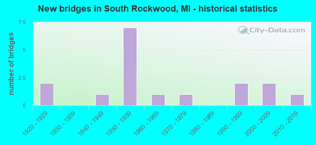
- New bridges - historical statistics
- 21920-1929
- 11940-1949
- 71950-1959
- 11960-1969
- 11970-1979
- 21990-1999
- 22000-2009
- 12010-2019

- Reconstructed bridges - Historical Statistics
- 21960-1969
- 01970-1979
- 21980-1989


- Bridge Condition - Deck
- 15.4%Very good
- 30.8%Good
- 15.4%Satisfactory
- 15.4%Fair
- 15.4%Poor
- 7.7%Serious

- Bridge Condition - Superstructure
- 7.7%Excellent
- 7.7%Very good
- 15.4%Good
- 30.8%Satisfactory
- 15.4%Fair
- 15.4%Poor
- 7.7%Serious

- Bridge Condition - Substructure
- 15.4%Very good
- 23.1%Good
- 15.4%Satisfactory
- 46.2%Fair

- Bridge Condition - Channel
- 10.0%Excellent
- 60.0%Satisfactory
- 20.0%Fair
- 10.0%Poor
Find on map >> Show street view
Structure Number: 2206, Location: 1 MI W OF HARDWOOD (Lat: 45.962375, Lng: -87.725044), Route carried "on" structure: County highway , Year Built: 1945, Status: Posted for load, Structure Length: 1.09m (3.58ft), Average Daily Traffic: 135 (year 2020), Truck Traffic: 20%, Average Future Daily Traffic: 146 (year 2040), Features Intersected: E BR STURGEON RIVER, Facility Carried by Structure: RIDEOUT ROAD
Minimum Vertical Clearance: 30.48m (100.00ft), Kilometerpoint: 0.095, Lanes on structure: 2, Owner: County Highway Agency, Approaching Roadway Width: 9.1m (29.9ft), Material/Design: Steel, Design/Construction: Stringer/Multi-beam, Number Of Spans In Main Unit: 1, Length of Maximum Span: 10.6m (34.8ft), Curb-To-Curb Width: 7.3m (24.0ft), Out-to-Out Width: 8.5m (27.9ft)
Condition: Deck: Satisfactory, Superstructure: Satisfactory, Substructure: Fair, Channel: Fair, Operating Rating: 48.6 metric tons, Method Used To Determine Operating Rating: Load Factor (LF) rating reported by rating factor (RF) method using MS18 loading, Inventory Rating: 29.8 metric tons, Method Used To Determine Inventory Rating: Load Factor (LF) rating reported by rating factor (RF) method using MS18 loading, Structural Evaluation: Somewhat better than minimum adequacy, Deck Geometry: Somewhat better than minimum adequacy, Waterway Adequacy: Better than present minimum criteria, Approach Roadway Alignment: Better than present minimum criteria, Bridge Posting: Required (Relationship of Operating Rating to Maximum Legal Load: 0.1 - 9.9% below), Designated Inspection Frequency: Every 24 months, Inspection Date: September 2020, Deck Structure Type: Concrete Cast-file-Place, Wearing Surface/Protective System: Wearing Surface: Gravel
Find on map >> Show street view
Structure Number: 7131, Location: 4.2 MI SW OF WAYNE COL (Lat: 42.039725, Lng: -83.332011), Route carried "on" structure: US 24, Year Built: 1922, Year Reconstructed: 1993, Status: Open, Structure Length: 1.12m (3.67ft), Average Daily Traffic: 10,923 (year 2007), Truck Traffic: 3%, Average Future Daily Traffic: 12,658 (year 2018), Design Load: HS 25 or greater, Features Intersected: LITTLE SWAN CREEK
Minimum Vertical Clearance: 30.48m (100.00ft), Kilometerpoint: 39.200, Lanes on structure: 4, Base Highway Network: Yes (Inventory Route: 430, Subroute: 1), Owner: State Highway Agency, Approaching Roadway Width: 13.4m (44.0ft), Material/Design: Prestressed concrete, Design/Construction: Stringer/Multi-beam, Number Of Spans In Main Unit: 1, Length of Maximum Span: 10.0m (32.8ft), Curb-To-Curb Width: 20.7m (67.9ft), Out-to-Out Width: 21.7m (71.2ft)
Condition: Deck: Good, Superstructure: Good, Substructure: Good, Channel: Satisfactory, Operating Rating: 68.4 metric tons, Method Used To Determine Operating Rating: Load Factor (LF) rating reported by rating factor (RF) method using MS18 loading, Inventory Rating: 40.8 metric tons, Method Used To Determine Inventory Rating: Load Factor (LF) rating reported by rating factor (RF) method using MS18 loading, Structural Evaluation: Better than present minimum criteria, Deck Geometry: Superior to present desirable criteria, Waterway Adequacy: Equal to present desirable criteria, Approach Roadway Alignment: Equal to present minimum criteria, Designated Inspection Frequency: Every 24 months, Inspection Date: August 2021, Deck Structure Type: Concrete Cast-file-Place, Wearing Surface/Protective System: Wearing Surface: Monolithic Concrete, Deck Protection: Epoxy Coated Reinforcing
Find on map >> Show street view
Structure Number: 7132, Location: 4.0 MI SW OF WAYNE COL (Lat: 42.042703, Lng: -83.329967), Route carried "on" structure: US 24, Year Built: 1922, Year Reconstructed: 1993, Status: Open, Structure Length: 3.14m (10.30ft), Average Daily Traffic: 10,923 (year 2007), Truck Traffic: 3%, Average Future Daily Traffic: 12,658 (year 2018), Design Load: HS 25 or greater, Features Intersected: SWAN CREEK
Minimum Vertical Clearance: 30.48m (100.00ft), Kilometerpoint: 39.572, Lanes on structure: 4, Base Highway Network: Yes (Inventory Route: 430, Subroute: 1), Owner: State Highway Agency, Approaching Roadway Width: 13.4m (44.0ft), Skew: 2 degrees, Material/Design: Prestressed concrete, Design/Construction: Stringer/Multi-beam, Number Of Spans In Main Unit: 1, Length of Maximum Span: 30.4m (99.7ft), Curb-To-Curb Width: 20.7m (67.9ft), Out-to-Out Width: 21.7m (71.2ft)
Condition: Deck: Good, Superstructure: Satisfactory, Substructure: Satisfactory, Channel: Satisfactory, Operating Rating: 63.8 metric tons, Method Used To Determine Operating Rating: Load Factor (LF) rating reported by rating factor (RF) method using MS18 loading, Inventory Rating: 39.2 metric tons, Method Used To Determine Inventory Rating: Load Factor (LF) rating reported by rating factor (RF) method using MS18 loading, Structural Evaluation: Equal to present minimum criteria, Deck Geometry: Superior to present desirable criteria, Waterway Adequacy: Equal to present desirable criteria, Approach Roadway Alignment: Equal to present desirable criteria, Designated Inspection Frequency: Every 24 months, Inspection Date: August 2021, Bridge Improvement Cost: $74,000, Deck Structure Type: Concrete Cast-file-Place, Wearing Surface/Protective System: Wearing Surface: Monolithic Concrete, Deck Protection: Epoxy Coated Reinforcing
Find on map >> Show street view
Structure Number: 7191, Location: 5.3 MI SW OF WAYNE COL (Lat: 42.006836, Lng: -83.312897), Route carried "on" structure: Interstate 75, Year Built: 1954, Year Reconstructed: 1973, Status: Open, Structure Length: 3.50m (11.48ft), Average Daily Traffic: 25,163 (year 2007), Truck Traffic: 32%, Average Future Daily Traffic: 30,544 (year 2018), Design Load: HS 20, Features Intersected: SWAN CREEK
Minimum Vertical Clearance: 30.48m (100.00ft), Kilometerpoint: 34.681, Lanes on structure: 4, Base Highway Network: Yes (Inventory Route: 122, Subroute: 10), Owner: State Highway Agency, Approaching Roadway Width: 16.4m (53.8ft), Skew: 10 degrees, Material/Design: Steel continuous, Design/Construction: Stringer/Multi-beam, Number Of Spans In Main Unit: 3, Length of Maximum Span: 13.7m (44.9ft), Curb-To-Curb Width: 20.4m (66.9ft), Out-to-Out Width: 21.4m (70.2ft)
Condition: Deck: Fair, Superstructure: Fair, Substructure: Fair, Channel: Satisfactory, Operating Rating: 76.5 metric tons, Method Used To Determine Operating Rating: Load Factor (LF) rating reported by rating factor (RF) method using MS18 loading, Inventory Rating: 45.7 metric tons, Method Used To Determine Inventory Rating: Load Factor (LF) rating reported by rating factor (RF) method using MS18 loading, Structural Evaluation: Somewhat better than minimum adequacy, Deck Geometry: Equal to present minimum criteria, Waterway Adequacy: Equal to present desirable criteria, Approach Roadway Alignment: Equal to present minimum criteria, Designated Inspection Frequency: Every 24 months, Inspection Date: June 2021, Deck Structure Type: Concrete Cast-file-Place, Wearing Surface/Protective System: Wearing Surface: Latex Concrete
Find on map >> Show street view
Structure Number: 7192, Location: 5.3 MI SW OF WAYNE COL (Lat: 42.006694, Lng: -83.312625), Route carried "on" structure: Interstate 75, Year Built: 1954, Year Reconstructed: 1973, Status: Open, Structure Length: 3.50m (11.48ft), Average Daily Traffic: 25,163 (year 2007), Truck Traffic: 32%, Average Future Daily Traffic: 30,544 (year 2018), Design Load: HS 20, Features Intersected: SWAN CREEK
Minimum Vertical Clearance: 30.48m (100.00ft), Kilometerpoint: 34.686, Lanes on structure: 3, Base Highway Network: Yes (Inventory Route: 122, Subroute: 9), Owner: State Highway Agency, Approaching Roadway Width: 16.4m (53.8ft), Skew: 10 degrees, Material/Design: Steel continuous, Design/Construction: Stringer/Multi-beam, Number Of Spans In Main Unit: 3, Length of Maximum Span: 13.7m (44.9ft), Curb-To-Curb Width: 16.4m (53.8ft), Out-to-Out Width: 17.0m (55.8ft)
Condition: Deck: Poor, Superstructure: Poor, Substructure: Fair, Channel: Satisfactory, Operating Rating: 76.5 metric tons, Method Used To Determine Operating Rating: Load Factor (LF) rating reported by rating factor (RF) method using MS18 loading, Inventory Rating: 45.7 metric tons, Method Used To Determine Inventory Rating: Load Factor (LF) rating reported by rating factor (RF) method using MS18 loading, Structural Evaluation: Meets minimum limits, Deck Geometry: Equal to present minimum criteria, Waterway Adequacy: Equal to present desirable criteria, Approach Roadway Alignment: Equal to present minimum criteria, Designated Inspection Frequency: Every 12 months, Other Special Inspection Frequency: Every 12 months, Inspection Date: June 2021, Other Special Inspection Date: December 2021, Deck Structure Type: Concrete Cast-file-Place, Wearing Surface/Protective System: Wearing Surface: Latex Concrete
Find on map >> Show street view
Structure Number: 7202, Location: 2.8 MI SW OF WAYNE COL (Lat: 42.037294, Lng: -83.287200), Route carried "on" structure: County highway , Year Built: 1954, Status: Open, Structure Length: 7.98m (26.18ft), Average Daily Traffic: 270 (year 1995), Truck Traffic: 3%, Average Future Daily Traffic: 270 (year 2015), Design Load: HS 20, Features Intersected: I-75, Facility Carried by Structure: SIGLER RD
Minimum Vertical Clearance: 30.48m (100.00ft), Kilometerpoint: 11.016, Lanes on structure: 2, Lanes under structure: 6, Owner: State Highway Agency, Approaching Roadway Width: 10.9m (35.8ft), Skew: 3 degrees, Material/Design: Concrete continuous, Design/Construction: Tee Beam, Number Of Spans In Main Unit: 4, Length of Maximum Span: 23.7m (77.8ft), Curb or Sidewalk Widths: Left: 0.4m (1.3ft), Right: 0.4m (1.3ft), Curb-To-Curb Width: 7.9m (25.9ft), Out-to-Out Width: 9.5m (31.2ft)
Condition: Deck: Poor, Superstructure: Satisfactory, Substructure: Fair, Operating Rating: 54.1 metric tons, Method Used To Determine Operating Rating: Load Factor (LF) rating reported by rating factor (RF) method using MS18 loading, Inventory Rating: 32.4 metric tons, Method Used To Determine Inventory Rating: Load Factor (LF) rating reported by rating factor (RF) method using MS18 loading, Structural Evaluation: Somewhat better than minimum adequacy, Deck Geometry: Somewhat better than minimum adequacy, Underclear: High priority of corrective action, Approach Roadway Alignment: Equal to present minimum criteria, Length Of Structure Improvement: 7.99m (26.21ft), Designated Inspection Frequency: Every 24 months, Inspection Date: May 2021, Bridge Improvement Cost: $91,000, Roadway Improvement Cost: $9,000, Total Project Cost: $107,000, Deck Structure Type: Concrete Cast-file-Place, Wearing Surface/Protective System: Wearing Surface: Monolithic Concrete
Find on map >> Show street view
Structure Number: 7203, Location: IN S ROCKWOOD (Lat: 42.051967, Lng: -83.269714), Route carried "on" structure: City street 2057, Year Built: 1956, Status: Open, Structure Length: 9.23m (30.28ft), Average Daily Traffic: 680 (year 1974), Average Future Daily Traffic: 680 (year 1977), Design Load: HS 20, Features Intersected: I-75, Facility Carried by Structure: READY RD
Minimum Vertical Clearance: 30.48m (100.00ft), Kilometerpoint: 9.138, Lanes on structure: 2, Lanes under structure: 6, Owner: State Highway Agency, Approaching Roadway Width: 10.9m (35.8ft), Skew: 4 degrees, Material/Design: Concrete continuous, Design/Construction: Tee Beam, Number Of Spans In Main Unit: 4, Length of Maximum Span: 27.4m (89.9ft), Curb or Sidewalk Widths: Left: 0.4m (1.3ft), Right: 0.4m (1.3ft), Curb-To-Curb Width: 7.9m (25.9ft), Out-to-Out Width: 9.5m (31.2ft)
Condition: Deck: Satisfactory, Superstructure: Poor, Substructure: Satisfactory, Operating Rating: 68.0 metric tons, Method Used To Determine Operating Rating: Load Factor (LF) rating reported by rating factor (RF) method using MS18 loading, Inventory Rating: 40.8 metric tons, Method Used To Determine Inventory Rating: Load Factor (LF) rating reported by rating factor (RF) method using MS18 loading, Structural Evaluation: Meets minimum limits, Deck Geometry: Somewhat better than minimum adequacy, Underclear: High priority of corrective action, Approach Roadway Alignment: Equal to present minimum criteria, Designated Inspection Frequency: Every 12 months, Inspection Date: June 2021, Deck Structure Type: Concrete Cast-file-Place, Wearing Surface/Protective System: Wearing Surface: Latex Concrete
Find on map >> Show street view
Structure Number: 7204, Location: IN S ROCKWOOD (Lat: 42.062778, Lng: -83.258331), Route carried "on" structure: City street 2060, Year Built: 2008, Status: Open, Structure Length: 7.74m (25.39ft), Average Daily Traffic: 7,300 (year 2006), Truck Traffic: 3%, Average Future Daily Traffic: 9,500 (year 2026), Design Load: HL 93, Features Intersected: I-75, Facility Carried by Structure: S HURON R DR
Minimum Vertical Clearance: 30.48m (100.00ft), Kilometerpoint: 4.468, Lanes on structure: 2, Lanes under structure: 6, Owner: State Highway Agency, Approaching Roadway Width: 12.2m (40.0ft), Skew: 1 degrees, Material/Design: Prestressed concrete, Design/Construction: Stringer/Multi-beam, Number Of Spans In Main Unit: 4, Length of Maximum Span: 27.3m (89.6ft), Curb or Sidewalk Widths: Left: 1.6m (5.2ft), Right: 1.6m (5.2ft), Curb-To-Curb Width: 8.5m (27.9ft), Out-to-Out Width: 12.4m (40.7ft)
Condition: Deck: Good, Superstructure: Good, Substructure: Good, Operating Rating: 52.5 metric tons, Method Used To Determine Operating Rating: Load and Resistance Factor Rating (LRFR) rating reported by rating factor(RF) method using HL-93 loadings, Inventory Rating: 40.5 metric tons, Method Used To Determine Inventory Rating: Load and Resistance Factor Rating (LRFR) rating reported by rating factor(RF) method using HL-93 loadings, Structural Evaluation: Better than present minimum criteria, Deck Geometry: Meets minimum limits, Underclear: High priority of corrective action, Approach Roadway Alignment: Equal to present minimum criteria, Designated Inspection Frequency: Every 24 months, Inspection Date: September 2021, Deck Structure Type: Concrete Cast-file-Place, Wearing Surface/Protective System: Wearing Surface: Monolithic Concrete, Deck Protection: Epoxy Coated Reinforcing
Find on map >> Show street view
Structure Number: 7293, Location: 1.75 MI W OF I 75 (Lat: 42.036475, Lng: -83.321267), Route carried "on" structure: County highway , Year Built: 1972, Status: Open, Structure Length: 3.65m (11.98ft), Average Daily Traffic: 850 (year 2017), Truck Traffic: 2%, Average Future Daily Traffic: 978 (year 2037), Design Load: H 20, Features Intersected: SWAN CREEK, Facility Carried by Structure: SIGLER RD
Minimum Vertical Clearance: 30.48m (100.00ft), Kilometerpoint: 8.190, Lanes on structure: 2, Owner: County Highway Agency, Approaching Roadway Width: 8.5m (27.9ft), Skew: 3 degrees, Material/Design: Prestressed concrete, Design/Construction: Box Beam or Girders - Multiple, Number Of Spans In Main Unit: 3, Length of Maximum Span: 11.8m (38.7ft), Curb-To-Curb Width: 8.2m (26.9ft), Out-to-Out Width: 9.3m (30.5ft)
Condition: Deck: Serious, Superstructure: Serious, Substructure: Fair, Channel: Satisfactory, Operating Rating: 64.8 metric tons, Method Used To Determine Operating Rating: Load Factor (LF) rating reported by rating factor (RF) method using MS18 loading, Inventory Rating: 39.2 metric tons, Method Used To Determine Inventory Rating: Load Factor (LF) rating reported by rating factor (RF) method using MS18 loading, Structural Evaluation: High priority of corrective action, Deck Geometry: Somewhat better than minimum adequacy, Waterway Adequacy: Equal to present desirable criteria, Approach Roadway Alignment: Meets minimum limits, Length Of Structure Improvement: 3.66m (12.01ft), Designated Inspection Frequency: Every 12 months, Inspection Date: November 2021, Bridge Improvement Cost: $257,000,000, Roadway Improvement Cost: $58,000,000, Total Project Cost: $355,000,000, Deck Structure Type: Concrete Precast Panels, Wearing Surface/Protective System: Wearing Surface: Bituminous
Find on map >> Show street view
Structure Number: 7294, Location: .05 MI N OF SWAN CRK RD (Lat: 42.003247, Lng: -83.308414), Route carried "on" structure: County highway , Year Built: 1965, Status: Open, Structure Length: 3.20m (10.50ft), Average Daily Traffic: 2,210 (year 2017), Truck Traffic: 1%, Average Future Daily Traffic: 2,541 (year 2037), Design Load: H 20, Features Intersected: SWAN CREEK, Facility Carried by Structure: BRANDON RD
Minimum Vertical Clearance: 30.48m (100.00ft), Kilometerpoint: 0.084, Lanes on structure: 2, Owner: County Highway Agency, Approaching Roadway Width: 6.7m (22.0ft), Skew: 2 degrees, Material/Design: Prestressed concrete, Design/Construction: Box Beam or Girders - Multiple, Number Of Spans In Main Unit: 3, Length of Maximum Span: 10.3m (33.8ft), Curb or Sidewalk Widths: Left: 0.5m (1.6ft), Right: 0.5m (1.6ft), Curb-To-Curb Width: 8.5m (27.9ft), Out-to-Out Width: 10.2m (33.5ft)
Condition: Deck: Fair, Superstructure: Fair, Substructure: Fair, Channel: Poor, Operating Rating: 75.5 metric tons, Method Used To Determine Operating Rating: Load Factor (LF) rating reported by rating factor (RF) method using MS18 loading, Inventory Rating: 45.0 metric tons, Method Used To Determine Inventory Rating: Load Factor (LF) rating reported by rating factor (RF) method using MS18 loading, Structural Evaluation: Somewhat better than minimum adequacy, Deck Geometry: Meets minimum limits, Waterway Adequacy: Equal to present minimum criteria, Approach Roadway Alignment: Equal to present minimum criteria, Designated Inspection Frequency: Every 24 months, Inspection Date: June 2021, Deck Structure Type: Concrete Precast Panels, Wearing Surface/Protective System: Wearing Surface: Integral Concrete
Find on map >> Show street view
Structure Number: 7305, Location: 0.5 MI E OF SWAN CREEK RD (Lat: 42.022333, Lng: -83.302686), Route carried "on" structure: County highway , Year Built: 1995, Status: Open, Structure Length: 3.38m (11.09ft), Average Daily Traffic: 20 (year 1995), Truck Traffic: 5%, Average Future Daily Traffic: 24 (year 2014), Design Load: HS 20, Features Intersected: SWAN CREEK, Facility Carried by Structure: LABO ROAD
Minimum Vertical Clearance: 30.48m (100.00ft), Kilometerpoint: 1.027, Lanes on structure: 2, Owner: County Highway Agency, Approaching Roadway Width: 6.7m (22.0ft), Material/Design: Prestressed concrete, Design/Construction: Box Beam or Girders - Multiple, Number Of Spans In Main Unit: 3, Length of Maximum Span: 15.5m (50.9ft), Curb-To-Curb Width: 7.6m (24.9ft), Out-to-Out Width: 7.6m (24.9ft)
Condition: Deck: Very good, Superstructure: Very good, Substructure: Good, Channel: Fair, Operating Rating: 59.3 metric tons, Method Used To Determine Operating Rating: Load Factor (LF) rating reported by rating factor (RF) method using MS18 loading, Inventory Rating: 35.3 metric tons, Method Used To Determine Inventory Rating: Load Factor (LF) rating reported by rating factor (RF) method using MS18 loading, Structural Evaluation: Better than present minimum criteria, Deck Geometry: Equal to present minimum criteria, Waterway Adequacy: Somewhat better than minimum adequacy, Approach Roadway Alignment: Equal to present minimum criteria, Designated Inspection Frequency: Every 24 months, Inspection Date: November 2020, Deck Structure Type: Concrete Precast Panels, Wearing Surface/Protective System: Wearing Surface: Bituminous, Membrane: Other
Find on map >> Show street view
Structure Number: 7317, Location: 0.15 MI N OF SWAN CREEK R (Lat: 42.002664, Lng: -83.301617), Route carried "on" structure: County highway , Year Built: 2015, Status: Open, Structure Length: 1.52m (4.99ft), Average Daily Traffic: 770 (year 2017), Truck Traffic: 1%, Average Future Daily Traffic: 886 (year 2037), Design Load: Greater than HL93, Features Intersected: SWAN CREEK, Facility Carried by Structure: DREW STREET
Minimum Vertical Clearance: 30.48m (100.00ft), Kilometerpoint: 0.219, Lanes on structure: 2, Owner: County Highway Agency, Approaching Roadway Width: 5.8m (19.0ft), Skew: 1 degrees, Material/Design: Prestressed concrete, Design/Construction: Box Beam or Girders - Multiple, Number Of Spans In Main Unit: 1, Length of Maximum Span: 14.8m (48.6ft), Curb or Sidewalk Widths: Left: 0.5m (1.6ft), Right: 0.5m (1.6ft), Curb-To-Curb Width: 8.5m (27.9ft), Out-to-Out Width: 9.5m (31.2ft)
Condition: Deck: Very good, Superstructure: Excellent, Substructure: Very good, Channel: Excellent, Operating Rating: 64.2 metric tons, Method Used To Determine Operating Rating: Load and Resistance Factor Rating (LRFR) rating reported by rating factor(RF) method using HL-93 loadings, Inventory Rating: 47.3 metric tons, Method Used To Determine Inventory Rating: Load and Resistance Factor Rating (LRFR) rating reported by rating factor(RF) method using HL-93 loadings, Structural Evaluation: Equal to present desirable criteria, Deck Geometry: Somewhat better than minimum adequacy, Waterway Adequacy: Better than present minimum criteria, Approach Roadway Alignment: Equal to present minimum criteria, Designated Inspection Frequency: Every 24 months, Inspection Date: November 2021, Deck Structure Type: Concrete Cast-file-Place, Wearing Surface/Protective System: Wearing Surface: Monolithic Concrete, Deck Protection: Epoxy Coated Reinforcing
Find on map >> Show street view
Structure Number: 10202, Location: SEC. 8-9 KENOCKEE TWP. (Lat: 43.046328, Lng: -82.714086), Route carried "on" structure: ServiceCounty highway , Year Built: 1997, Status: Open, Structure Length: 3.02m (9.91ft), Average Daily Traffic: 56 (year 1997), Average Future Daily Traffic: 150 (year 2017), Design Load: HS 20, Features Intersected: MILL CREEK, Facility Carried by Structure: BROWN ROAD
Minimum Vertical Clearance: 30.48m (100.00ft), Kilometerpoint: 3.264, Lanes on structure: 2, Owner: County Highway Agency, Approaching Roadway Width: 9.1m (29.9ft), Material/Design: Prestressed concrete, Design/Construction: Box Beam or Girders - Multiple, Number Of Spans In Main Unit: 1, Length of Maximum Span: 28.3m (92.8ft), Curb-To-Curb Width: 9.8m (32.2ft), Out-to-Out Width: 10.4m (34.1ft)
Condition: Deck: Good, Superstructure: Satisfactory, Substructure: Very good, Channel: Satisfactory, Operating Rating: 79.7 metric tons, Method Used To Determine Operating Rating: Load Factor (LF) rating reported by rating factor (RF) method using MS18 loading, Inventory Rating: 47.6 metric tons, Method Used To Determine Inventory Rating: Load Factor (LF) rating reported by rating factor (RF) method using MS18 loading, Structural Evaluation: Equal to present minimum criteria, Deck Geometry: Equal to present desirable criteria, Waterway Adequacy: Equal to present desirable criteria, Approach Roadway Alignment: Equal to present minimum criteria, Designated Inspection Frequency: Every 24 months, Inspection Date: March 2021, Deck Structure Type: Concrete Precast Panels, Wearing Surface/Protective System: Wearing Surface: Bituminous
Find on map >> Show street view
Structure Number: 7201, Location: 6.2 MI NE OF M-50 (Lat: 42.005714, Lng: -83.313667), Route carried "under" structure: Interstate 75, Year Built: 1955, Structure Length: 0. m, Average Daily Traffic: 50,326 (year 2007), Truck Traffic: 32%, Features Intersected: I-75, Facility Carried by Structure: NEWPORT RD
Minimum Vertical Clearance: 5.11m (16.77ft), Kilometerpoint: 34.543, Lanes on structure: 2, Lanes under structure: 7, Material/Design: Concrete continuous, Design/Construction: Tee Beam, Length of Maximum Span: 24.7m (81.0ft)
Find on map >> Show street view
Structure Number: 7202, Location: 2.8 MI SW OF WAYNE COL (Lat: 42.037294, Lng: -83.287200), Route carried "under" structure: Interstate 75, Year Built: 1954, Structure Length: 0. m, Average Daily Traffic: 50,326 (year 2007), Truck Traffic: 32%, Features Intersected: I-75, Facility Carried by Structure: SIGLER RD
Minimum Vertical Clearance: 4.95m (16.24ft), Kilometerpoint: 38.680, Lanes on structure: 2, Lanes under structure: 6, Material/Design: Concrete continuous, Design/Construction: Tee Beam, Length of Maximum Span: 23.7m (77.8ft)
Find on map >> Show street view
Structure Number: 7203, Location: IN S ROCKWOOD (Lat: 42.051967, Lng: -83.269714), Route carried "under" structure: Interstate 75, Year Built: 1956, Structure Length: 0. m, Average Daily Traffic: 50,326 (year 2007), Truck Traffic: 32%, Features Intersected: I-75, Facility Carried by Structure: READY RD
Minimum Vertical Clearance: 4.80m (15.75ft), Kilometerpoint: 40.861, Lanes on structure: 2, Lanes under structure: 6, Material/Design: Concrete continuous, Design/Construction: Tee Beam, Length of Maximum Span: 27.4m (89.9ft)
Find on map >> Show street view
Structure Number: 7204, Location: IN S ROCKWOOD (Lat: 42.062778, Lng: -83.258331), Route carried "under" structure: Interstate 75, Year Built: 2008, Structure Length: 0. m, Average Daily Traffic: 53,858 (year 2007), Truck Traffic: 30%, Features Intersected: I-75, Facility Carried by Structure: S HURON R DR
Minimum Vertical Clearance: 4.47m (14.67ft), Kilometerpoint: 42.395, Lanes on structure: 2, Lanes under structure: 6, Material/Design: Prestressed concrete, Design/Construction: Stringer/Multi-beam, Length of Maximum Span: 27.3m (89.6ft)