Bridge Statistics for South Pottstown, Pennsylvania (PA)
Condition, Traffic, Stress, Structural Evaluation, Project Costs
- National Bridge Inventory (NBI) Statistics
- 13Number of bridges
- 43ft / 13.5mTotal length
- $1,450,000Total costs
- 255,205Total average daily traffic
- 22,565Total average daily truck traffic
- National Bridge Inventory (NBI) Registered Bridges for South Pottstown
- No street view available for this location
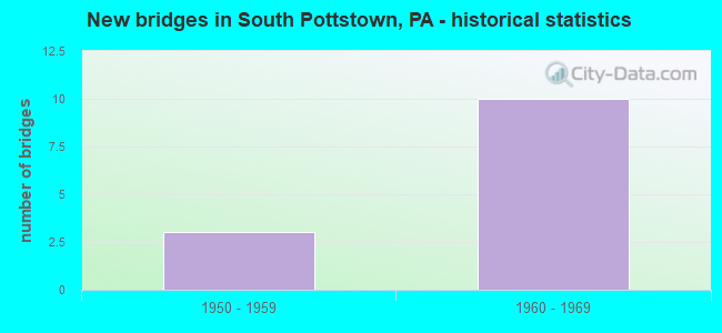
- New bridges - historical statistics
- 31950-1959
- 101960-1969


- Bridge Condition - Superstructure
- 40.0%Good
- 40.0%Satisfactory
- 20.0%Fair

- Bridge Condition - Substructure
- 20.0%Good
- 40.0%Satisfactory
- 40.0%Fair
Find on map >> Show street view
Structure Number: 10074, Location: COVENTRY MALL 2D13 (Lat: 40.233417, Lng: -75.660194), Route carried "on" structure: State highway 100, Year Built: 1954, Year Reconstructed: 1998, Status: Open, Structure Length: 4.75m (15.58ft), Average Daily Traffic: 20,942 (year 2021), Truck Traffic: 8%, Average Future Daily Traffic: 24,129 (year 2032), Design Load: HS 20, Features Intersected: SCHUYLKILL ROAD, Facility Carried by Structure: POTTSTOWN BY-PASS
Minimum Vertical Clearance: 30+ m (98+ ft), Kilometerpoint: 33.288, Lanes on structure: 2, Lanes under structure: 4, Base Highway Network: Yes, Owner: State Highway Agency, Approaching Roadway Width: 23.2m (76.1ft), Skew: 31 degrees, Material/Design: Steel continuous, Design/Construction: Stringer/Multi-beam, Number Of Spans In Main Unit: 3, Length of Maximum Span: 23.8m (78.1ft), Curb or Sidewalk Widths: Left: 0.2m (0.7ft), Right: 0.2m (0.7ft), Curb-To-Curb Width: 24.1m (79.1ft), Out-to-Out Width: 25.9m (85.0ft)
Condition: Deck: Satisfactory, Superstructure: Satisfactory, Substructure: Satisfactory, Operating Rating: 56.2 metric tons, Method Used To Determine Operating Rating: Load Factor (LF), Inventory Rating: 33.6 metric tons, Method Used To Determine Inventory Rating: Load Factor (LF), Structural Evaluation: Equal to present minimum criteria, Deck Geometry: Superior to present desirable criteria, Underclear: High priority of corrective action, Approach Roadway Alignment: Equal to present desirable criteria, Length Of Structure Improvement: 5.70m (18.70ft), Designated Inspection Frequency: Every 24 months, Inspection Date: July 2021, Deck Structure Type: Concrete Cast-file-Place, Wearing Surface/Protective System: Wearing Surface: Integral Concrete
Find on map >> Show street view
Structure Number: 10235, Location: POTTSTOWN 02D11 (Lat: 40.240203, Lng: -75.661639), Route carried "on" structure: US 422, Year Built: 1966, Status: Open, Structure Length: 1.13m (3.71ft), Average Daily Traffic: 33,114 (year 2022), Truck Traffic: 10%, Average Future Daily Traffic: 43,542 (year 2032), Design Load: HS 20, Features Intersected: LAURELWOOD ROAD (LOCAL), Facility Carried by Structure: POTTSTOWN BY-PASS
Minimum Vertical Clearance: 30+ m (98+ ft), Kilometerpoint: 1.003, Lanes on structure: 2, Lanes under structure: 2, Base Highway Network: Yes, Owner: State Highway Agency, Approaching Roadway Width: 26.8m (87.9ft), Skew: 31 degrees, Material/Design: Prestressed concrete, Design/Construction: Stringer/Multi-beam, Number Of Spans In Main Unit: 1, Length of Maximum Span: 11.0m (36.1ft), Curb or Sidewalk Widths: Left: 0.5m (1.6ft), Right: 0.5m (1.6ft), Curb-To-Curb Width: 26.8m (87.9ft), Out-to-Out Width: 29.0m (95.1ft)
Condition: Deck: Satisfactory, Superstructure: Good, Substructure: Satisfactory, Operating Rating: 51.7 metric tons, Method Used To Determine Operating Rating: Load Factor (LF), Inventory Rating: 29.0 metric tons, Method Used To Determine Inventory Rating: Load Factor (LF), Structural Evaluation: Equal to present minimum criteria, Deck Geometry: Superior to present desirable criteria, Underclear: Equal to present minimum criteria, Approach Roadway Alignment: Equal to present desirable criteria, Length Of Structure Improvement: 1.70m (5.58ft), Designated Inspection Frequency: Every 24 months, Inspection Date: July 2021, Deck Structure Type: Concrete Cast-file-Place, Wearing Surface/Protective System: Wearing Surface: Bituminous
Find on map >> Show street view
Structure Number: 10236, Location: SOUTH POTTSTOWN 2D12 (Lat: 40.239367, Lng: -75.658853), Route carried "on" structure: US 422, Year Built: 1966, Status: Open, Structure Length: 3.35m (10.99ft), Average Daily Traffic: 55,507 (year 2021), Truck Traffic: 8%, Average Future Daily Traffic: 63,942 (year 2032), Design Load: HS 20, Features Intersected: POTTSTOWN PIKE, Facility Carried by Structure: POTTSTOWN BY-PASS
Minimum Vertical Clearance: 30+ m (98+ ft), Kilometerpoint: 1.003, Lanes on structure: 3, Lanes under structure: 6, Base Highway Network: Yes, Owner: State Highway Agency, Approaching Roadway Width: 29.3m (96.1ft), Skew: 32 degrees, Material/Design: Prestressed concrete, Design/Construction: Stringer/Multi-beam, Number Of Spans In Main Unit: 1, Length of Maximum Span: 32.3m (106.0ft), Curb or Sidewalk Widths: Left: 0.5m (1.6ft), Right: 0.5m (1.6ft), Curb-To-Curb Width: 29.3m (96.1ft), Out-to-Out Width: 32.2m (105.6ft)
Condition: Deck: Satisfactory, Superstructure: Fair, Substructure: Fair, Operating Rating: 79.8 metric tons, Method Used To Determine Operating Rating: Load Factor (LF), Inventory Rating: 26.3 metric tons, Method Used To Determine Inventory Rating: Load Factor (LF), Structural Evaluation: Somewhat better than minimum adequacy, Deck Geometry: Superior to present desirable criteria, Underclear: Equal to present minimum criteria, Approach Roadway Alignment: Equal to present desirable criteria, Length Of Structure Improvement: 4.20m (13.78ft), Designated Inspection Frequency: Every 24 months, Inspection Date: July 2021, Bridge Improvement Cost: $92,000, Roadway Improvement Cost: $272,000, Total Project Cost: $1,247,000, Deck Structure Type: Concrete Cast-file-Place, Wearing Surface/Protective System: Wearing Surface: Bituminous
Find on map >> Show street view
Structure Number: 10237, Location: POTTSTOWN 2E12 (Lat: 40.237908, Lng: -75.651811), Route carried "on" structure: US 422, Year Built: 1965, Status: Open, Structure Length: 1.49m (4.89ft), Average Daily Traffic: 55,507 (year 2021), Truck Traffic: 8%, Average Future Daily Traffic: 63,942 (year 2032), Design Load: HS 20, Features Intersected: HANOVER STREET, Facility Carried by Structure: POTTSTOWN BY-PASS
Minimum Vertical Clearance: 30+ m (98+ ft), Kilometerpoint: 1.873, Lanes on structure: 3, Lanes under structure: 2, Base Highway Network: Yes, Owner: State Highway Agency, Approaching Roadway Width: 28.3m (92.8ft), Skew: 31 degrees, Material/Design: Prestressed concrete, Design/Construction: Stringer/Multi-beam, Number Of Spans In Main Unit: 1, Length of Maximum Span: 14.6m (47.9ft), Curb or Sidewalk Widths: Left: 0.4m (1.3ft), Right: 0.4m (1.3ft), Curb-To-Curb Width: 26.8m (87.9ft), Out-to-Out Width: 29.9m (98.1ft)
Condition: Deck: Satisfactory, Superstructure: Satisfactory, Substructure: Fair, Operating Rating: 66.2 metric tons, Method Used To Determine Operating Rating: Load Factor (LF), Inventory Rating: 24.5 metric tons, Method Used To Determine Inventory Rating: Load Factor (LF), Structural Evaluation: Somewhat better than minimum adequacy, Deck Geometry: Superior to present desirable criteria, Underclear: High priority of corrective action, Approach Roadway Alignment: Equal to present desirable criteria, Length Of Structure Improvement: 2.10m (6.89ft), Designated Inspection Frequency: Every 24 months, Inspection Date: July 2021, Bridge Improvement Cost: $15,000, Roadway Improvement Cost: $44,000, Total Project Cost: $203,000, Deck Structure Type: Concrete Cast-file-Place, Wearing Surface/Protective System: Wearing Surface: Bituminous
Find on map >> Show street view
Structure Number: 10238, Location: SOUTH OF POTTSTOWN 2G13 (Lat: 40.232828, Lng: -75.635308), Route carried "on" structure: State highway , Year Built: 1965, Status: Open, Structure Length: 2.77m (9.09ft), Average Daily Traffic: 426 (year 2021), Truck Traffic: 7%, Average Future Daily Traffic: 10,318 (year 2032), Design Load: HS 20, Features Intersected: POTTSTOWN BY-PASS, Facility Carried by Structure: KEIM STREET
Minimum Vertical Clearance: 30+ m (98+ ft), Kilometerpoint: 0.000, Lanes on structure: 2, Lanes under structure: 4, Owner: State Highway Agency, Approaching Roadway Width: 12.2m (40.0ft), Material/Design: Prestressed concrete, Design/Construction: Stringer/Multi-beam, Number Of Spans In Main Unit: 1, Length of Maximum Span: 26.2m (86.0ft), Curb-To-Curb Width: 12.2m (40.0ft), Out-to-Out Width: 13.9m (45.6ft)
Condition: Deck: Satisfactory, Superstructure: Good, Substructure: Good, Operating Rating: 74.4 metric tons, Method Used To Determine Operating Rating: Load Factor (LF), Inventory Rating: 27.2 metric tons, Method Used To Determine Inventory Rating: Load Factor (LF), Structural Evaluation: Equal to present minimum criteria, Deck Geometry: Equal to present desirable criteria, Underclear: High priority of corrective action, Approach Roadway Alignment: Equal to present desirable criteria, Length Of Structure Improvement: 3.40m (11.15ft), Designated Inspection Frequency: Every 24 months, Inspection Date: July 2021, Deck Structure Type: Concrete Cast-file-Place, Wearing Surface/Protective System: Wearing Surface: Monolithic Concrete
Find on map >> Show street view
Structure Number: 10074, Location: COVENTRY MALL 2D13 (Lat: 40.233417, Lng: -75.660194), Route carried "under" structure: State highway 724, Year Built: 1954, Structure Length: 0. m, Average Daily Traffic: 4,028 (year 2022), Truck Traffic: 8%, Features Intersected: SCHUYLKILL ROAD, Facility Carried by Structure: POTTSTOWN BY-PASS
Minimum Vertical Clearance: 4.67m (15.32ft), Kilometerpoint: 3.048, Lanes on structure: 2, Lanes under structure: 2, Material/Design: Steel continuous, Design/Construction: Stringer/Multi-beam, Length of Maximum Span: 23.8m (78.1ft)
Find on map >> Show street view
Structure Number: 10074, Location: COVENTRY MALL 2D13 (Lat: 40.233417, Lng: -75.660194), Route carried "under" structure: State highway 724, Year Built: 1954, Structure Length: 0. m, Average Daily Traffic: 3,919 (year 2022), Truck Traffic: 11%, Features Intersected: SCHUYLKILL ROAD, Facility Carried by Structure: POTTSTOWN BY-PASS
Minimum Vertical Clearance: 4.32m (14.17ft), Kilometerpoint: 3.048, Lanes on structure: 2, Lanes under structure: 2, Material/Design: Steel continuous, Design/Construction: Stringer/Multi-beam, Length of Maximum Span: 23.8m (78.1ft)
Find on map >> Show street view
Structure Number: 10235, Location: POTTSTOWN 02D11 (Lat: 40.240203, Lng: -75.661639), Route carried "under" structure: State highway , Year Built: 1966, Structure Length: 0. m, Average Daily Traffic: 1,900 (year 1980), Truck Traffic: 3%, Features Intersected: LAURELWOOD ROAD (LOCAL), Facility Carried by Structure: POTTSTOWN BY-PASS
Minimum Vertical Clearance: 4.44m (14.57ft), Kilometerpoint: 0.000, Lanes on structure: 2, Lanes under structure: 2, Material/Design: Prestressed concrete, Design/Construction: Stringer/Multi-beam, Length of Maximum Span: 11.0m (36.1ft)
Find on map >> Show street view
Structure Number: 10236, Location: SOUTH POTTSTOWN 2D12 (Lat: 40.239367, Lng: -75.658853), Route carried "under" structure: State highway 100, Year Built: 1966, Structure Length: 0. m, Average Daily Traffic: 14,514 (year 2022), Truck Traffic: 11%, Features Intersected: POTTSTOWN PIKE, Facility Carried by Structure: POTTSTOWN BY-PASS
Minimum Vertical Clearance: 4.93m (16.17ft), Kilometerpoint: 33.292, Lanes on structure: 3, Lanes under structure: 3, Material/Design: Prestressed concrete, Design/Construction: Stringer/Multi-beam, Length of Maximum Span: 32.3m (106.0ft)
Find on map >> Show street view
Structure Number: 10236, Location: SOUTH POTTSTOWN 2D12 (Lat: 40.239367, Lng: -75.658853), Route carried "under" structure: State highway 100, Year Built: 1966, Structure Length: 0. m, Average Daily Traffic: 13,273 (year 2022), Truck Traffic: 11%, Features Intersected: POTTSTOWN PIKE, Facility Carried by Structure: POTTSTOWN BY-PASS
Minimum Vertical Clearance: 4.60m (15.09ft), Kilometerpoint: 33.288, Lanes on structure: 3, Lanes under structure: 3, Material/Design: Prestressed concrete, Design/Construction: Stringer/Multi-beam, Length of Maximum Span: 32.3m (106.0ft)
Find on map >> Show street view
Structure Number: 10237, Location: POTTSTOWN 2E12 (Lat: 40.237908, Lng: -75.651811), Route carried "under" structure: State highway , Year Built: 1965, Structure Length: 0. m, Average Daily Traffic: 9,407 (year 2022), Truck Traffic: 8%, Features Intersected: HANOVER STREET, Facility Carried by Structure: POTTSTOWN BY-PASS
Minimum Vertical Clearance: 4.78m (15.68ft), Kilometerpoint: 2.581, Lanes on structure: 3, Lanes under structure: 2, Material/Design: Prestressed concrete, Design/Construction: Stringer/Multi-beam, Length of Maximum Span: 14.6m (47.9ft)
Find on map >> Show street view
Structure Number: 10238, Location: SOUTH OF POTTSTOWN 2G13 (Lat: 40.232828, Lng: -75.635308), Route carried "under" structure: US 422, Year Built: 1965, Structure Length: 0. m, Average Daily Traffic: 21,364 (year 2020), Truck Traffic: 8%, Features Intersected: POTTSTOWN BY-PASS, Facility Carried by Structure: KEIM STREET
Minimum Vertical Clearance: 4.72m (15.49ft), Kilometerpoint: 3.391, Lanes on structure: 2, Lanes under structure: 2, Material/Design: Prestressed concrete, Design/Construction: Stringer/Multi-beam, Length of Maximum Span: 26.2m (86.0ft)
Find on map >> Show street view
Structure Number: 10238, Location: SOUTH OF POTTSTOWN 2G13 (Lat: 40.232828, Lng: -75.635308), Route carried "under" structure: US 422, Year Built: 1965, Structure Length: 0. m, Average Daily Traffic: 21,304 (year 2020), Truck Traffic: 11%, Features Intersected: POTTSTOWN BY-PASS, Facility Carried by Structure: KEIM STREET
Minimum Vertical Clearance: 5.49m (18.01ft), Kilometerpoint: 3.404, Lanes on structure: 2, Lanes under structure: 2, Material/Design: Prestressed concrete, Design/Construction: Stringer/Multi-beam, Length of Maximum Span: 26.2m (86.0ft)