Bridge Statistics for South Pasadena, California (CA)
Condition, Traffic, Stress, Structural Evaluation, Project Costs
- National Bridge Inventory (NBI) Statistics
- 18Number of bridges
- 135ft / 40.7mTotal length
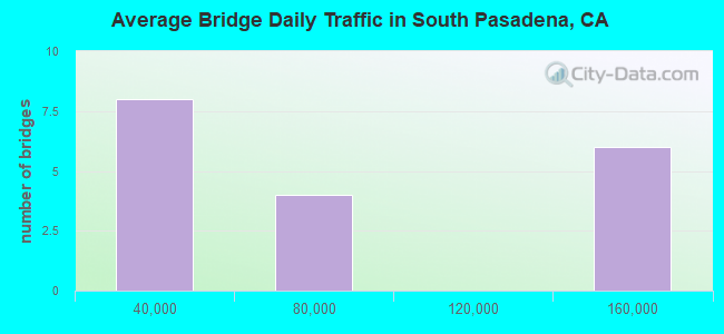
- 1,096,000Total average daily traffic
- 21,400Total average daily truck traffic
- National Bridge Inventory (NBI) Registered Bridges for South Pasadena
- No street view available for this location
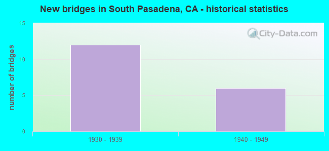
- New bridges - historical statistics
- 121930-1939
- 61940-1949
Find on map >> Show street view
Structure Number: 53 0276, Location: 07-LA-110-30.10-SPAS (Lat: 34.117586, Lng: -118.168883), Route carried "on" structure: State highway 110, Year Built: 1939, Status: Open, Structure Length: 13.17m (43.21ft), Average Daily Traffic: 130,000 (year 2021), Truck Traffic: 2%, Average Future Daily Traffic: 123,082 (year 2040), Design Load: HS 15, Features Intersected: RAMP, STONEY,ARROYO SECO
Minimum Vertical Clearance: 30+ m (98+ ft), Kilometerpoint: 30.100, Lanes on structure: 6, Lanes under structure: 3, Base Highway Network: Yes (Inventory Route: 1, Subroute: 1), Owner: State Highway Agency, Approaching Roadway Width: 23.2m (76.1ft), Skew: 26 degrees, Material/Design: Concrete continuous, Design/Construction: Box Beam or Girders - Multiple, Number Of Spans In Main Unit: 3, Number Of Approach Spans: 2, Length of Maximum Span: 36.0m (118.1ft), Curb or Sidewalk Widths: Left: 1.5m (4.9ft), Right: 1.5m (4.9ft), Curb-To-Curb Width: 21.3m (69.9ft), Out-to-Out Width: 26.9m (88.3ft)
Condition: Deck: Good, Superstructure: Good, Substructure: Good, Channel: Excellent, Operating Rating: 55.7 metric tons, Method Used To Determine Operating Rating: Load Factor (LF), Inventory Rating: 33.4 metric tons, Method Used To Determine Inventory Rating: Load Factor (LF), Structural Evaluation: Better than present minimum criteria, Deck Geometry: High priority of replacement, Underclear: High priority of corrective action, Waterway Adequacy: Superior to present desirable criteria, Approach Roadway Alignment: Superior to present desirable criteria, Designated Inspection Frequency: Every 24 months, Inspection Date: September 2021, Deck Structure Type: Concrete Cast-file-Place
Find on map >> Show street view
Structure Number: 53 043, Location: 07-LA-110-28.76-LA (Lat: 34.107881, Lng: -118.186381), Route carried "on" structure: City street , Year Built: 1939, Status: Open, Structure Length: 9.27m (30.41ft), Average Daily Traffic: 12,000 (year 2019), Truck Traffic: 1%, Average Future Daily Traffic: 14,034 (year 2041), Design Load: HS 15, Features Intersected: STATE ROUTE 110, Facility Carried by Structure: AVENUE 60
Minimum Vertical Clearance: 30+ m (98+ ft), Kilometerpoint: 0.000, Lanes on structure: 2, Lanes under structure: 6, Owner: State Highway Agency, Approaching Roadway Width: 14.0m (45.9ft), Skew: 9 degrees, Material/Design: Concrete, Design/Construction: Arch - Deck, Number Of Spans In Main Unit: 5, Length of Maximum Span: 30.5m (100.1ft), Curb or Sidewalk Widths: Left: 1.2m (3.9ft), Right: 1.2m (3.9ft), Curb-To-Curb Width: 14.0m (45.9ft), Out-to-Out Width: 17.7m (58.1ft)
Condition: Deck: Good, Superstructure: Good, Substructure: Good, Operating Rating: 46.7 metric tons, Method Used To Determine Operating Rating: Load Factor (LF), Inventory Rating: 27.9 metric tons, Method Used To Determine Inventory Rating: Load Factor (LF), Structural Evaluation: Better than present minimum criteria, Deck Geometry: Superior to present desirable criteria, Underclear: High priority of corrective action, Approach Roadway Alignment: Superior to present desirable criteria, Designated Inspection Frequency: Every 24 months, Inspection Date: September 2021, Deck Structure Type: Concrete Cast-file-Place, Wearing Surface/Protective System: Wearing Surface: Bituminous
Find on map >> Show street view
Structure Number: 53 0432, Location: 07-LA-110-30.27-SPAS (Lat: 34.118256, Lng: -118.165828), Route carried "on" structure: State highway 110, Year Built: 1938, Status: Open, Structure Length: 0.64m (2.10ft), Average Daily Traffic: 130,000 (year 2019), Truck Traffic: 2%, Average Future Daily Traffic: 123,492 (year 2041), Design Load: HS 15, Features Intersected: EQUESTRIAN ACCESS
Minimum Vertical Clearance: 30+ m (98+ ft), Kilometerpoint: 30.270, Lanes on structure: 6, Base Highway Network: Yes (Inventory Route: 1, Subroute: 1), Owner: State Highway Agency, Approaching Roadway Width: 35.0m (114.8ft), Skew: 33 degrees, Material/Design: Concrete, Design/Construction: Slab, Number Of Spans In Main Unit: 1, Length of Maximum Span: 5.8m (19.0ft), Curb-To-Curb Width: 35.0m (114.8ft), Out-to-Out Width: 35.0m (114.8ft)
Condition: Deck: Good, Superstructure: Good, Substructure: Good, Operating Rating: 55.7 metric tons, Method Used To Determine Operating Rating: Load Factor (LF), Inventory Rating: 33.4 metric tons, Method Used To Determine Inventory Rating: Load Factor (LF), Structural Evaluation: Better than present minimum criteria, Deck Geometry: Superior to present desirable criteria, Approach Roadway Alignment: Superior to present desirable criteria, Designated Inspection Frequency: Every 24 months, Inspection Date: September 2021, Deck Structure Type: Concrete Cast-file-Place
Find on map >> Show street view
Structure Number: 53 0433, Location: 07-LA-110-30.30-SPAS (Lat: 34.118619, Lng: -118.165511), Route carried "on" structure: City street , Year Built: 1938, Status: Open, Structure Length: 4.36m (14.30ft), Average Daily Traffic: 4,000 (year 2021), Truck Traffic: 1%, Average Future Daily Traffic: 4,534 (year 2038), Design Load: HS 15, Features Intersected: STATE ROUTE 110, Facility Carried by Structure: ARROYO DRIVE
Minimum Vertical Clearance: 30+ m (98+ ft), Kilometerpoint: 0.000, Lanes on structure: 2, Lanes under structure: 6, Owner: State Highway Agency, Approaching Roadway Width: 12.2m (40.0ft), Skew: 2 degrees, Material/Design: Concrete continuous, Design/Construction: Tee Beam, Number Of Spans In Main Unit: 3, Length of Maximum Span: 28.3m (92.8ft), Curb or Sidewalk Widths: Left: 1.7m (5.6ft), Right: 1.7m (5.6ft), Curb-To-Curb Width: 12.2m (40.0ft), Out-to-Out Width: 16.2m (53.1ft)
Condition: Deck: Good, Superstructure: Good, Substructure: Good, Operating Rating: 57.3 metric tons, Method Used To Determine Operating Rating: Load Factor (LF), Inventory Rating: 34.3 metric tons, Method Used To Determine Inventory Rating: Load Factor (LF), Structural Evaluation: Better than present minimum criteria, Deck Geometry: Equal to present minimum criteria, Underclear: High priority of corrective action, Approach Roadway Alignment: Superior to present desirable criteria, Designated Inspection Frequency: Every 48 months, Inspection Date: Febuary 2021, Deck Structure Type: Concrete Cast-file-Place
Find on map >> Show street view
Structure Number: 53 0434, Location: 07-LA-110-30.43-SPAS (Lat: 34.119031, Lng: -118.163294), Route carried "on" structure: City street , Year Built: 1938, Status: Open, Structure Length: 2.71m (8.89ft), Average Daily Traffic: 3,000 (year 2019), Truck Traffic: 1%, Average Future Daily Traffic: 3,470 (year 2041), Design Load: HS 15, Features Intersected: STATE ROUTE 110, Facility Carried by Structure: GRAND AVENUE
Minimum Vertical Clearance: 30+ m (98+ ft), Kilometerpoint: 0.000, Lanes on structure: 2, Lanes under structure: 6, Owner: State Highway Agency, Approaching Roadway Width: 14.6m (47.9ft), Skew: 1 degrees, Material/Design: Concrete continuous, Design/Construction: Slab, Number Of Spans In Main Unit: 2, Length of Maximum Span: 12.5m (41.0ft), Curb or Sidewalk Widths: Left: 1.5m (4.9ft), Right: 1.5m (4.9ft), Curb-To-Curb Width: 14.6m (47.9ft), Out-to-Out Width: 18.3m (60.0ft)
Condition: Deck: Good, Superstructure: Good, Substructure: Good, Operating Rating: 40.8 metric tons, Method Used To Determine Operating Rating: Load Factor (LF), Inventory Rating: 24.6 metric tons, Method Used To Determine Inventory Rating: Load Factor (LF), Structural Evaluation: Equal to present minimum criteria, Deck Geometry: Superior to present desirable criteria, Underclear: High priority of corrective action, Approach Roadway Alignment: Superior to present desirable criteria, Designated Inspection Frequency: Every 24 months, Inspection Date: September 2021, Deck Structure Type: Concrete Cast-file-Place
Find on map >> Show street view
Structure Number: 53 0435, Location: 07-LA-110-30.59-SPAS (Lat: 34.119350, Lng: -118.160622), Route carried "on" structure: City street , Year Built: 1939, Status: Open, Structure Length: 2.65m (8.69ft), Average Daily Traffic: 11,000 (year 2019), Truck Traffic: 1%, Average Future Daily Traffic: 12,614 (year 2041), Design Load: HS 15, Features Intersected: STATE ROUTE 110, Facility Carried by Structure: ORANGE GROVE AVE
Minimum Vertical Clearance: 30+ m (98+ ft), Kilometerpoint: 0.000, Lanes on structure: 4, Lanes under structure: 6, Owner: State Highway Agency, Approaching Roadway Width: 17.1m (56.1ft), Material/Design: Concrete continuous, Design/Construction: Slab, Number Of Spans In Main Unit: 2, Length of Maximum Span: 12.2m (40.0ft), Curb or Sidewalk Widths: Left: 1.5m (4.9ft), Right: 1.5m (4.9ft), Curb-To-Curb Width: 17.1m (56.1ft), Out-to-Out Width: 20.7m (67.9ft)
Condition: Deck: Good, Superstructure: Good, Substructure: Good, Operating Rating: 43.1 metric tons, Method Used To Determine Operating Rating: Load Factor (LF), Inventory Rating: 25.9 metric tons, Method Used To Determine Inventory Rating: Load Factor (LF), Structural Evaluation: Equal to present minimum criteria, Deck Geometry: Somewhat better than minimum adequacy, Underclear: High priority of corrective action, Approach Roadway Alignment: Superior to present desirable criteria, Designated Inspection Frequency: Every 24 months, Inspection Date: September 2021, Deck Structure Type: Concrete Cast-file-Place
Find on map >> Show street view
Structure Number: 53 0436, Location: 07-LA-110-30.70-SPAS (Lat: 34.119178, Lng: -118.158614), Route carried "on" structure: City street , Year Built: 1939, Status: Open, Structure Length: 2.62m (8.60ft), Average Daily Traffic: 2,000 (year 2019), Truck Traffic: 1%, Average Future Daily Traffic: 2,312 (year 2041), Design Load: HS 15, Features Intersected: STATE ROUTE 110, Facility Carried by Structure: PROSPECT AVE
Minimum Vertical Clearance: 30+ m (98+ ft), Kilometerpoint: 0.000, Lanes on structure: 2, Lanes under structure: 6, Owner: State Highway Agency, Approaching Roadway Width: 11.0m (36.1ft), Material/Design: Concrete continuous, Design/Construction: Slab, Number Of Spans In Main Unit: 2, Length of Maximum Span: 12.2m (40.0ft), Curb or Sidewalk Widths: Left: 1.5m (4.9ft), Right: 1.5m (4.9ft), Curb-To-Curb Width: 11.0m (36.1ft), Out-to-Out Width: 14.6m (47.9ft)
Condition: Deck: Good, Superstructure: Good, Substructure: Good, Operating Rating: 41.5 metric tons, Method Used To Determine Operating Rating: Load Factor (LF), Inventory Rating: 24.9 metric tons, Method Used To Determine Inventory Rating: Load Factor (LF), Structural Evaluation: Equal to present minimum criteria, Deck Geometry: Equal to present minimum criteria, Underclear: High priority of corrective action, Approach Roadway Alignment: Superior to present desirable criteria, Designated Inspection Frequency: Every 24 months, Inspection Date: September 2021, Deck Structure Type: Concrete Cast-file-Place
Find on map >> Show street view
Structure Number: 53 0437, Location: 07-LA-110-30.78-SPAS (Lat: 34.119189, Lng: -118.157200), Route carried "on" structure: City street , Year Built: 1940, Status: Open, Structure Length: 2.62m (8.60ft), Average Daily Traffic: 2,000 (year 2021), Truck Traffic: 1%, Average Future Daily Traffic: 2,266 (year 2038), Design Load: HS 15, Features Intersected: STATE ROUTE 110, Facility Carried by Structure: MERIDIAN AVNUE
Minimum Vertical Clearance: 30+ m (98+ ft), Kilometerpoint: 0.000, Lanes on structure: 2, Lanes under structure: 6, Owner: State Highway Agency, Approaching Roadway Width: 12.8m (42.0ft), Material/Design: Concrete continuous, Design/Construction: Slab, Number Of Spans In Main Unit: 2, Length of Maximum Span: 12.2m (40.0ft), Curb or Sidewalk Widths: Left: 1.5m (4.9ft), Right: 1.5m (4.9ft), Curb-To-Curb Width: 12.8m (42.0ft), Out-to-Out Width: 16.7m (54.8ft)
Condition: Deck: Good, Superstructure: Good, Substructure: Good, Operating Rating: 58.0 metric tons, Method Used To Determine Operating Rating: Load Factor (LF), Inventory Rating: 35.0 metric tons, Method Used To Determine Inventory Rating: Load Factor (LF), Structural Evaluation: Better than present minimum criteria, Deck Geometry: Better than present minimum criteria, Underclear: High priority of corrective action, Approach Roadway Alignment: Superior to present desirable criteria, Designated Inspection Frequency: Every 48 months, Inspection Date: Febuary 2021, Deck Structure Type: Concrete Cast-file-Place
Find on map >> Show street view
Structure Number: 53 0438, Location: 07-LA-110-31.01-SPAS (Lat: 34.119225, Lng: -118.153214), Route carried "on" structure: City street , Year Built: 1940, Status: Open, Structure Length: 2.62m (8.60ft), Average Daily Traffic: 17,000 (year 2019), Truck Traffic: 1%, Average Future Daily Traffic: 19,973 (year 2041), Design Load: H 15, Features Intersected: STATE ROUTE 110, Facility Carried by Structure: FREMONT AVENUE
Minimum Vertical Clearance: 30+ m (98+ ft), Kilometerpoint: 0.000, Lanes on structure: 2, Lanes under structure: 6, Owner: State Highway Agency, Approaching Roadway Width: 11.0m (36.1ft), Material/Design: Concrete continuous, Design/Construction: Slab, Number Of Spans In Main Unit: 2, Length of Maximum Span: 12.2m (40.0ft), Curb or Sidewalk Widths: Left: 1.5m (4.9ft), Right: 1.5m (4.9ft), Curb-To-Curb Width: 11.0m (36.1ft), Out-to-Out Width: 14.6m (47.9ft)
Condition: Deck: Good, Superstructure: Good, Substructure: Good, Operating Rating: 38.6 metric tons, Method Used To Determine Operating Rating: Load Factor (LF), Inventory Rating: 23.3 metric tons, Method Used To Determine Inventory Rating: Load Factor (LF), Structural Evaluation: Somewhat better than minimum adequacy, Deck Geometry: Meets minimum limits, Underclear: High priority of corrective action, Approach Roadway Alignment: Superior to present desirable criteria, Designated Inspection Frequency: Every 24 months, Inspection Date: September 2021, Deck Structure Type: Concrete Cast-file-Place
Find on map >> Show street view
Structure Number: 53 0276, Location: 07-LA-110-30.10-SPAS (Lat: 34.117586, Lng: -118.168883), Route carried "under" structure: Ramp State highway 110, Year Built: 1939, Structure Length: 0. m, Average Daily Traffic: 1,000 (year 2021), Truck Traffic: 1%, Features Intersected: RAMP, STONEY,ARROYO SECO
Minimum Vertical Clearance: 4.22m (13.85ft), Kilometerpoint: 30.100, Lanes on structure: 6, Lanes under structure: 1, Material/Design: Concrete continuous, Design/Construction: Box Beam or Girders - Multiple, Length of Maximum Span: 36.0m (118.1ft)
Find on map >> Show street view
Structure Number: 53 0433, Location: 07-LA-110-30.30-SPAS (Lat: 34.118619, Lng: -118.165511), Route carried "under" structure: State highway 110, Year Built: 1938, Structure Length: 0. m, Average Daily Traffic: 130,000 (year 2011), Truck Traffic: 2%, Features Intersected: STATE ROUTE 110, Facility Carried by Structure: ARROYO DRIVE
Minimum Vertical Clearance: 4.45m (14.60ft), Kilometerpoint: 30.300, Lanes on structure: 2, Lanes under structure: 6, Material/Design: Concrete continuous, Design/Construction: Tee Beam, Length of Maximum Span: 28.3m (92.8ft)
Find on map >> Show street view
Structure Number: 53 0434, Location: 07-LA-110-30.43-SPAS (Lat: 34.119031, Lng: -118.163294), Route carried "under" structure: State highway 110, Year Built: 1938, Structure Length: 0. m, Average Daily Traffic: 130,000 (year 2011), Truck Traffic: 2%, Features Intersected: STATE ROUTE 110, Facility Carried by Structure: GRAND AVENUE
Minimum Vertical Clearance: 4.67m (15.32ft), Kilometerpoint: 30.430, Lanes on structure: 2, Lanes under structure: 6, Material/Design: Concrete continuous, Design/Construction: Slab, Length of Maximum Span: 12.5m (41.0ft)
Find on map >> Show street view
Structure Number: 53 0435, Location: 07-LA-110-30.59-SPAS (Lat: 34.119350, Lng: -118.160622), Route carried "under" structure: State highway 110, Year Built: 1939, Structure Length: 0. m, Average Daily Traffic: 130,000 (year 2011), Truck Traffic: 2%, Features Intersected: STATE ROUTE 110, Facility Carried by Structure: ORANGE GROVE AVE
Minimum Vertical Clearance: 4.70m (15.42ft), Kilometerpoint: 30.590, Lanes on structure: 4, Lanes under structure: 6, Material/Design: Concrete continuous, Design/Construction: Slab, Length of Maximum Span: 12.2m (40.0ft)
Find on map >> Show street view
Structure Number: 53 0436, Location: 07-LA-110-30.70-SPAS (Lat: 34.119178, Lng: -118.158614), Route carried "under" structure: State highway 110, Year Built: 1939, Structure Length: 0. m, Average Daily Traffic: 130,000 (year 2011), Truck Traffic: 2%, Features Intersected: STATE ROUTE 110, Facility Carried by Structure: PROSPECT AVE
Minimum Vertical Clearance: 4.75m (15.58ft), Kilometerpoint: 30.700, Lanes on structure: 2, Lanes under structure: 6, Material/Design: Concrete continuous, Design/Construction: Slab, Length of Maximum Span: 12.2m (40.0ft)
Find on map >> Show street view
Structure Number: 53 0437, Location: 07-LA-110-30.78-SPAS (Lat: 34.119189, Lng: -118.157200), Route carried "under" structure: State highway 110, Year Built: 1940, Structure Length: 0. m, Average Daily Traffic: 66,000 (year 2011), Truck Traffic: 2%, Features Intersected: STATE ROUTE 110, Facility Carried by Structure: MERIDIAN AVNUE
Minimum Vertical Clearance: 4.90m (16.08ft), Kilometerpoint: 30.780, Lanes on structure: 2, Lanes under structure: 6, Material/Design: Concrete continuous, Design/Construction: Slab, Length of Maximum Span: 12.2m (40.0ft)
Find on map >> Show street view
Structure Number: 53 0438, Location: 07-LA-110-31.01-SPAS (Lat: 34.119225, Lng: -118.153214), Route carried "under" structure: State highway 110, Year Built: 1940, Structure Length: 0. m, Average Daily Traffic: 66,000 (year 2011), Truck Traffic: 2%, Features Intersected: STATE ROUTE 110, Facility Carried by Structure: FREMONT AVENUE
Minimum Vertical Clearance: 4.52m (14.83ft), Kilometerpoint: 31.010, Lanes on structure: 2, Lanes under structure: 6, Material/Design: Concrete continuous, Design/Construction: Slab, Length of Maximum Span: 12.2m (40.0ft)
Find on map >> Show street view
Structure Number: 53 0439, Location: 07-LA-110-31.03-SPAS (Lat: 34.119261, Lng: -118.152669), Route carried "under" structure: State highway 110, Year Built: 1940, Structure Length: 0. m, Average Daily Traffic: 66,000 (year 2011), Truck Traffic: 2%, Features Intersected: STATE ROUTE 110, Facility Carried by Structure: METROLINK
Minimum Vertical Clearance: 4.55m (14.93ft), Kilometerpoint: 31.030, Lanes under structure: 6, Material/Design: Steel, Design/Construction: Girder and Floorbeam System, Length of Maximum Span: 20.7m (67.9ft)
Find on map >> Show street view
Structure Number: 53 044, Location: 07-LA-110-31.17-SPAS (Lat: 34.119311, Lng: -118.150472), Route carried "under" structure: State highway 110, Year Built: 1940, Structure Length: 0. m, Average Daily Traffic: 66,000 (year 2011), Truck Traffic: 2%, Features Intersected: STATE ROUTE 110, Facility Carried by Structure: FAIR OAKS AVENUE
Minimum Vertical Clearance: 4.57m (14.99ft), Kilometerpoint: 31.170, Lanes on structure: 5, Lanes under structure: 6, Material/Design: Concrete continuous, Design/Construction: Slab, Length of Maximum Span: 12.2m (40.0ft)