Bridge Statistics for South Jacksonville, Illinois (IL)
Condition, Traffic, Stress, Structural Evaluation, Project Costs
- National Bridge Inventory (NBI) Statistics
- 11Number of bridges
- 105ft / 32.3mTotal length
- 49,200Total average daily traffic
- 12,021Total average daily truck traffic
- National Bridge Inventory (NBI) Registered Bridges for South Jacksonville
- No street view available for this location
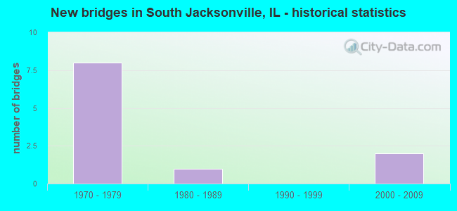
- New bridges - historical statistics
- 81970-1979
- 11980-1989
- 22000-2009


- Bridge Condition - Deck
- 71.4%Good
- 28.6%Satisfactory

- Bridge Condition - Superstructure
- 71.4%Good
- 28.6%Satisfactory

- Bridge Condition - Substructure
- 28.6%Very good
- 42.9%Satisfactory
- 28.6%Fair

- Bridge Condition - Channel
- 66.7%Very good
- 33.3%Good
Find on map >> Show street view
Structure Number: 690034, Location: 2.5M S IL104-JACKSVL (Lat: 39.686700, Lng: -90.228661), Route carried "on" structure: State highway 267, Year Built: 1975, Status: Open, Structure Length: 7.68m (25.20ft), Average Daily Traffic: 6,450 (year 2021), Truck Traffic: 9%, Average Future Daily Traffic: 7,169 (year 2032), Design Load: HS 20, Features Intersected: I-72/US 36
Minimum Vertical Clearance: 30+ m (98+ ft), Kilometerpoint: 83.925, Lanes on structure: 2, Lanes under structure: 4, Base Highway Network: Yes, Owner: State Highway Agency, Approaching Roadway Width: 7.3m (24.0ft), Skew: 30 degrees, Material/Design: Steel continuous, Design/Construction: Stringer/Multi-beam, Number Of Spans In Main Unit: 2, Number Of Approach Spans: 2, Length of Maximum Span: 33.1m (108.6ft), Curb-To-Curb Width: 19.7m (64.6ft), Out-to-Out Width: 20.7m (67.9ft)
Condition: Deck: Good, Superstructure: Satisfactory, Substructure: Satisfactory, Operating Rating: 72.9 metric tons, Method Used To Determine Operating Rating: Load Factor (LF) rating reported by rating factor (RF) method using MS18 loading, Inventory Rating: 43.7 metric tons, Method Used To Determine Inventory Rating: Load Factor (LF) rating reported by rating factor (RF) method using MS18 loading, Structural Evaluation: Equal to present minimum criteria, Deck Geometry: Superior to present desirable criteria, Underclear: Somewhat better than minimum adequacy, Approach Roadway Alignment: Equal to present desirable criteria, Designated Inspection Frequency: Every 24 months, Inspection Date: May 2020, Deck Structure Type: Concrete Cast-file-Place, Wearing Surface/Protective System: Wearing Surface: Other
Find on map >> Show street view
Structure Number: 690035, Location: 0.5 M E US67/IL267 (Lat: 39.686364, Lng: -90.222050), Route carried "on" structure: Interstate 72, Year Built: 1975, Status: Open, Structure Length: 4.61m (15.12ft), Average Daily Traffic: 4,900 (year 2021), Truck Traffic: 33%, Average Future Daily Traffic: 3,929 (year 2032), Design Load: HS 20, Features Intersected: ICG RR
Minimum Vertical Clearance: 30+ m (98+ ft), Kilometerpoint: 105.280, Lanes on structure: 2, Base Highway Network: Yes, Owner: State Highway Agency, Approaching Roadway Width: 12.8m (42.0ft), Material/Design: Steel continuous, Design/Construction: Stringer/Multi-beam, Number Of Spans In Main Unit: 3, Length of Maximum Span: 16.5m (54.1ft), Curb-To-Curb Width: 11.8m (38.7ft), Out-to-Out Width: 12.8m (42.0ft)
Condition: Deck: Good, Superstructure: Satisfactory, Substructure: Fair, Operating Rating: 68.7 metric tons, Method Used To Determine Operating Rating: Load Factor (LF) rating reported by rating factor (RF) method using MS18 loading, Inventory Rating: 41.1 metric tons, Method Used To Determine Inventory Rating: Load Factor (LF) rating reported by rating factor (RF) method using MS18 loading, Structural Evaluation: Somewhat better than minimum adequacy, Deck Geometry: Equal to present minimum criteria, Underclear: Better than present minimum criteria, Approach Roadway Alignment: Equal to present desirable criteria, Designated Inspection Frequency: Every 24 months, Inspection Date: April 2020, Deck Structure Type: Concrete Cast-file-Place, Wearing Surface/Protective System: Wearing Surface: Other
Find on map >> Show street view
Structure Number: 690036, Location: 0.5M E US67/IL267 (Lat: 39.686369, Lng: -90.221847), Route carried "on" structure: Interstate 72, Year Built: 1975, Status: Open, Structure Length: 4.61m (15.12ft), Average Daily Traffic: 4,900 (year 2021), Truck Traffic: 33%, Average Future Daily Traffic: 3,929 (year 2032), Design Load: HS 20, Features Intersected: ICG RR
Minimum Vertical Clearance: 30+ m (98+ ft), Kilometerpoint: 105.296, Lanes on structure: 2, Base Highway Network: Yes, Owner: State Highway Agency, Approaching Roadway Width: 12.8m (42.0ft), Material/Design: Steel continuous, Design/Construction: Stringer/Multi-beam, Number Of Spans In Main Unit: 3, Length of Maximum Span: 16.5m (54.1ft), Curb-To-Curb Width: 11.7m (38.4ft), Out-to-Out Width: 12.8m (42.0ft)
Condition: Deck: Satisfactory, Superstructure: Good, Substructure: Satisfactory, Operating Rating: 68.7 metric tons, Method Used To Determine Operating Rating: Load Factor (LF) rating reported by rating factor (RF) method using MS18 loading, Inventory Rating: 41.1 metric tons, Method Used To Determine Inventory Rating: Load Factor (LF) rating reported by rating factor (RF) method using MS18 loading, Structural Evaluation: Equal to present minimum criteria, Deck Geometry: Equal to present minimum criteria, Underclear: Better than present minimum criteria, Approach Roadway Alignment: Equal to present desirable criteria, Designated Inspection Frequency: Every 24 months, Inspection Date: April 2020, Deck Structure Type: Concrete Cast-file-Place, Wearing Surface/Protective System: Wearing Surface: Other
Find on map >> Show street view
Structure Number: 690057, Location: 2.25 MI W IL 267 (Lat: 39.680383, Lng: -90.267831), Route carried "on" structure: Interstate 72, Year Built: 1977, Status: Open, Structure Length: 3.60m (11.81ft), Average Daily Traffic: 5,250 (year 2021), Truck Traffic: 33%, Average Future Daily Traffic: 4,301 (year 2032), Design Load: HS 20, Features Intersected: MASSEY LANE TR 128
Minimum Vertical Clearance: 30+ m (98+ ft), Kilometerpoint: 101.048, Lanes on structure: 2, Lanes under structure: 2, Base Highway Network: Yes, Owner: State Highway Agency, Approaching Roadway Width: 12.8m (42.0ft), Material/Design: Steel continuous, Design/Construction: Stringer/Multi-beam, Number Of Spans In Main Unit: 3, Length of Maximum Span: 14.6m (47.9ft), Curb-To-Curb Width: 11.7m (38.4ft), Out-to-Out Width: 12.8m (42.0ft)
Condition: Deck: Satisfactory, Superstructure: Good, Substructure: Fair, Operating Rating: 64.5 metric tons, Method Used To Determine Operating Rating: Load Factor (LF) rating reported by rating factor (RF) method using MS18 loading, Inventory Rating: 38.9 metric tons, Method Used To Determine Inventory Rating: Load Factor (LF) rating reported by rating factor (RF) method using MS18 loading, Structural Evaluation: Somewhat better than minimum adequacy, Deck Geometry: Equal to present minimum criteria, Underclear: Meets minimum limits, Approach Roadway Alignment: Equal to present desirable criteria, Designated Inspection Frequency: Every 24 months, Inspection Date: Febuary 2022, Deck Structure Type: Concrete Cast-file-Place, Wearing Surface/Protective System: Wearing Surface: Other
Find on map >> Show street view
Structure Number: 690058, Location: 2.25 MI W IL 267 (Lat: 39.680383, Lng: -90.267831), Route carried "on" structure: Interstate 72, Year Built: 1977, Status: Open, Structure Length: 4.39m (14.40ft), Average Daily Traffic: 5,250 (year 2021), Truck Traffic: 33%, Average Future Daily Traffic: 4,301 (year 2032), Design Load: HS 20, Features Intersected: MASSEY LANE TR 128
Minimum Vertical Clearance: 30+ m (98+ ft), Kilometerpoint: 101.048, Lanes on structure: 2, Lanes under structure: 2, Base Highway Network: Yes, Owner: State Highway Agency, Approaching Roadway Width: 12.8m (42.0ft), Material/Design: Steel continuous, Design/Construction: Stringer/Multi-beam, Number Of Spans In Main Unit: 3, Length of Maximum Span: 14.6m (47.9ft), Curb-To-Curb Width: 11.7m (38.4ft), Out-to-Out Width: 12.8m (42.0ft)
Condition: Deck: Good, Superstructure: Good, Substructure: Satisfactory, Operating Rating: 58.3 metric tons, Method Used To Determine Operating Rating: Load Factor (LF) rating reported by rating factor (RF) method using MS18 loading, Inventory Rating: 35.0 metric tons, Method Used To Determine Inventory Rating: Load Factor (LF) rating reported by rating factor (RF) method using MS18 loading, Structural Evaluation: Equal to present minimum criteria, Deck Geometry: Equal to present minimum criteria, Underclear: Meets minimum limits, Approach Roadway Alignment: Equal to present desirable criteria, Designated Inspection Frequency: Every 24 months, Inspection Date: Febuary 2022, Deck Structure Type: Concrete Cast-file-Place, Wearing Surface/Protective System: Wearing Surface: Other
Find on map >> Show street view
Structure Number: 690504, Location: .6M S I72/US36 INT (Lat: 39.677706, Lng: -90.228683), Route carried "on" structure: State highway 267, Year Built: 2006, Status: Open, Structure Length: 3.41m (11.19ft), Average Daily Traffic: 4,100 (year 2021), Truck Traffic: 16%, Average Future Daily Traffic: 5,947 (year 2032), Design Load: HS 20, Features Intersected: SANDY CREEK
Minimum Vertical Clearance: 30+ m (98+ ft), Kilometerpoint: 82.927, Lanes on structure: 2, Base Highway Network: Yes, Owner: State Highway Agency, Approaching Roadway Width: 12.2m (40.0ft), Material/Design: Steel continuous, Design/Construction: Stringer/Multi-beam, Number Of Spans In Main Unit: 2, Length of Maximum Span: 19.7m (64.6ft), Curb-To-Curb Width: 12.2m (40.0ft), Out-to-Out Width: 13.2m (43.3ft)
Condition: Deck: Good, Superstructure: Good, Substructure: Very good, Channel: Very good, Operating Rating: 74.2 metric tons, Method Used To Determine Operating Rating: Load Factor (LF) rating reported by rating factor (RF) method using MS18 loading, Inventory Rating: 44.7 metric tons, Method Used To Determine Inventory Rating: Load Factor (LF) rating reported by rating factor (RF) method using MS18 loading, Structural Evaluation: Better than present minimum criteria, Deck Geometry: Equal to present minimum criteria, Waterway Adequacy: Superior to present desirable criteria, Approach Roadway Alignment: Equal to present desirable criteria, Designated Inspection Frequency: Every 48 months, Inspection Date: March 2021, Deck Structure Type: Concrete Cast-file-Place, Wearing Surface/Protective System: Deck Protection: Epoxy Coated Reinforcing
Find on map >> Show street view
Structure Number: 692005, Location: 1.2M N I72/US36 INT (Lat: 39.703525, Lng: -90.229261), Route carried "on" structure: State highway 267, Year Built: 1989, Status: Open, Structure Length: 0.97m (3.18ft), Average Daily Traffic: 6,450 (year 2021), Truck Traffic: 9%, Average Future Daily Traffic: 7,169 (year 2032), Design Load: HS 20, Features Intersected: TRIB MAUVAISE TERRE
Minimum Vertical Clearance: 30+ m (98+ ft), Kilometerpoint: 85.792, Lanes on structure: 2, Base Highway Network: Yes, Owner: State Highway Agency, Approaching Roadway Width: 12.2m (40.0ft), Skew: 3 degrees, Material/Design: Concrete, Design/Construction: Culvert, Number Of Spans In Main Unit: 3, Length of Maximum Span: 3.0m (9.8ft)
Condition: Channel: Good, Culverts: Good, Operating Rating: 62.2 metric tons, Method Used To Determine Operating Rating: Load Factor (LF) rating reported by rating factor (RF) method using MS18 loading, Inventory Rating: 36.9 metric tons, Method Used To Determine Inventory Rating: Load Factor (LF) rating reported by rating factor (RF) method using MS18 loading, Structural Evaluation: Better than present minimum criteria, Waterway Adequacy: Equal to present minimum criteria, Approach Roadway Alignment: Equal to present desirable criteria, Designated Inspection Frequency: Every 48 months, Inspection Date: March 2019
Find on map >> Show street view
Structure Number: 693256, Location: 2 MI SW JACKSONVILLE (Lat: 39.678672, Lng: -90.267619), Route carried "on" structure: County highway , Year Built: 2005, Status: Open, Structure Length: 3.05m (10.01ft), Average Daily Traffic: 700 (year 2019), Truck Traffic: 13%, Average Future Daily Traffic: 797 (year 2032), Design Load: HS 20, Features Intersected: BIG SANDY CRK., Facility Carried by Structure: TR 128
Minimum Vertical Clearance: 30+ m (98+ ft), Kilometerpoint: 3.347, Lanes on structure: 2, Owner: Town or Township Highway Agency, Approaching Roadway Width: 6.7m (22.0ft), Material/Design: Prestressed concrete, Design/Construction: Box Beam or Girders - Multiple, Number Of Spans In Main Unit: 3, Length of Maximum Span: 11.8m (38.7ft), Curb-To-Curb Width: 8.4m (27.6ft), Out-to-Out Width: 8.5m (27.9ft)
Condition: Deck: Good, Superstructure: Good, Substructure: Very good, Channel: Very good, Operating Rating: 44.1 metric tons, Method Used To Determine Operating Rating: Assigned rating based on Load Factor Design (LFD) reported by rating factor (RF) using MS18 loading, Inventory Rating: 32.4 metric tons, Method Used To Determine Inventory Rating: Assigned rating based on Load Factor Design (LFD) reported by rating factor (RF) using MS18 loading, Structural Evaluation: Better than present minimum criteria, Deck Geometry: Somewhat better than minimum adequacy, Waterway Adequacy: Equal to present desirable criteria, Approach Roadway Alignment: Equal to present desirable criteria, Designated Inspection Frequency: Every 48 months, Inspection Date: November 2017, Deck Structure Type: Concrete Precast Panels, Wearing Surface/Protective System: Wearing Surface: Gravel
Find on map >> Show street view
Structure Number: 690034, Location: 2.5M S IL104-JACKSVL (Lat: 39.686392, Lng: -90.228661), Route carried "under" structure: Interstate 72, Year Built: 1975, Structure Length: 0. m, Average Daily Traffic: 9,800 (year 2021), Truck Traffic: 33%, Features Intersected: I-72/US 36, Facility Carried by Structure: IL 267/US 67/BL 67
Minimum Vertical Clearance: 4.98m (16.34ft), Kilometerpoint: 104.524, Lanes on structure: 2, Lanes under structure: 4, Material/Design: Steel continuous, Design/Construction: Stringer/Multi-beam, Length of Maximum Span: 33.1m (108.6ft)
Find on map >> Show street view
Structure Number: 690057, Location: 2.25 MI W IL 267 (Lat: 39.680719, Lng: -90.267575), Route carried "under" structure: County highway , Year Built: 1977, Structure Length: 0. m, Average Daily Traffic: 700 (year 2019), Truck Traffic: 13%, Features Intersected: MASSEY LANE TR 128, Facility Carried by Structure: FAI 72/US 36/US67
Minimum Vertical Clearance: 4.32m (14.17ft), Kilometerpoint: 3.138, Lanes on structure: 2, Lanes under structure: 2, Material/Design: Steel continuous, Design/Construction: Stringer/Multi-beam, Length of Maximum Span: 14.6m (47.9ft)
Find on map >> Show street view
Structure Number: 690058, Location: 2.25 MI W IL 267 (Lat: 39.680400, Lng: -90.267581), Route carried "under" structure: County highway , Year Built: 1977, Structure Length: 0. m, Average Daily Traffic: 700 (year 2019), Truck Traffic: 13%, Features Intersected: MASSEY LANE TR 128, Facility Carried by Structure: FAI 72/US 36/US67
Minimum Vertical Clearance: 6.55m (21.49ft), Kilometerpoint: 3.170, Lanes on structure: 2, Lanes under structure: 2, Material/Design: Steel continuous, Design/Construction: Stringer/Multi-beam, Length of Maximum Span: 14.6m (47.9ft)