Bridge Statistics for South Haven, Michigan (MI)
Condition, Traffic, Stress, Structural Evaluation, Project Costs
- National Bridge Inventory (NBI) Statistics
- 39Number of bridges
- 358ft / 109mTotal length
- $780,000Total costs
- 243,214Total average daily traffic
- 51,569Total average daily truck traffic
- National Bridge Inventory (NBI) Registered Bridges for South Haven
- No street view available for this location
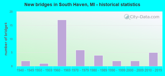
- New bridges - historical statistics
- 21940-1949
- 11950-1959
- 171960-1969
- 61970-1979
- 41980-1989
- 21990-1999
- 22000-2009
- 52010-2019

- Reconstructed bridges - Historical Statistics
- 31980-1989
- 01990-1999
- 22000-2009
- 12010-2019


- Bridge Condition - Deck
- 8.3%Very good
- 45.8%Good
- 20.8%Satisfactory
- 20.8%Fair
- 4.2%Poor

- Bridge Condition - Superstructure
- 20.8%Very good
- 12.5%Good
- 16.7%Satisfactory
- 45.8%Fair
- 4.2%Poor

- Bridge Condition - Substructure
- 29.2%Good
- 50.0%Satisfactory
- 8.3%Fair
- 8.3%Poor
- 4.2%Serious

- Bridge Condition - Channel
- 14.3%Very good
- 14.3%Good
- 47.6%Satisfactory
- 23.8%Fair

- Bridge Condition - Culverts
- 20.0%Very good
- 40.0%Good
- 40.0%Satisfactory
Find on map >> Show street view
Structure Number: 107, Location: 3.0 MI N OF VAN BUREN COL (Lat: 42.455803, Lng: -86.235144), Route carried "on" structure: Interstate 196, Year Built: 1963, Status: Open, Structure Length: 3.88m (12.73ft), Average Daily Traffic: 10,500 (year 2010), Truck Traffic: 22%, Average Future Daily Traffic: 12,850 (year 2030), Design Load: HS 20+Mod, Features Intersected: 71 ST STREET
Minimum Vertical Clearance: 30.48m (100.00ft), Kilometerpoint: 4.368, Lanes on structure: 2, Lanes under structure: 2, Base Highway Network: Yes (Inventory Route: 78, Subroute: 7), Owner: State Highway Agency, Approaching Roadway Width: 11.0m (36.1ft), Skew: 3 degrees, Material/Design: Prestressed concrete, Design/Construction: Stringer/Multi-beam, Number Of Spans In Main Unit: 3, Length of Maximum Span: 14.6m (47.9ft), Curb-To-Curb Width: 12.0m (39.4ft), Out-to-Out Width: 13.1m (43.0ft)
Condition: Deck: Satisfactory, Superstructure: Satisfactory, Substructure: Satisfactory, Operating Rating: 53.6 metric tons, Method Used To Determine Operating Rating: Load Factor (LF), Inventory Rating: 32.1 metric tons, Method Used To Determine Inventory Rating: Load Factor (LF), Structural Evaluation: Equal to present minimum criteria, Deck Geometry: Equal to present minimum criteria, Underclear: Meets minimum limits, Approach Roadway Alignment: Equal to present desirable criteria, Designated Inspection Frequency: Every 24 months, Inspection Date: May 2021, Bridge Improvement Cost: $25,000, Deck Structure Type: Concrete Cast-file-Place, Wearing Surface/Protective System: Wearing Surface: Latex Concrete
Find on map >> Show street view
Structure Number: 109, Location: 4.0 MI N OF VAN BUREN COL (Lat: 42.469644, Lng: -86.222828), Route carried "on" structure: County highway , Year Built: 1963, Status: Open, Structure Length: 7.04m (23.10ft), Average Daily Traffic: 300 (year 1984), Average Future Daily Traffic: 100 (year 1977), Design Load: H 15, Features Intersected: I-196 & US-31, Facility Carried by Structure: 107 TH AVE
Minimum Vertical Clearance: 30.48m (100.00ft), Kilometerpoint: 1.963, Lanes on structure: 2, Lanes under structure: 4, Owner: State Highway Agency, Approaching Roadway Width: 6.7m (22.0ft), Skew: 1 degrees, Material/Design: Prestressed concrete, Design/Construction: Stringer/Multi-beam, Number Of Spans In Main Unit: 4, Length of Maximum Span: 23.2m (76.1ft), Curb or Sidewalk Widths: Left: 0.8m (2.6ft), Right: 0.8m (2.6ft), Curb-To-Curb Width: 7.3m (24.0ft), Out-to-Out Width: 9.6m (31.5ft)
Condition: Deck: Fair, Superstructure: Satisfactory, Substructure: Satisfactory, Operating Rating: 50.5 metric tons, Method Used To Determine Operating Rating: Load Factor (LF) rating reported by rating factor (RF) method using MS18 loading, Inventory Rating: 30.1 metric tons, Method Used To Determine Inventory Rating: Load Factor (LF) rating reported by rating factor (RF) method using MS18 loading, Structural Evaluation: Equal to present minimum criteria, Deck Geometry: Somewhat better than minimum adequacy, Underclear: Somewhat better than minimum adequacy, Approach Roadway Alignment: Equal to present minimum criteria, Designated Inspection Frequency: Every 24 months, Inspection Date: May 2021, Deck Structure Type: Concrete Cast-file-Place, Wearing Surface/Protective System: Wearing Surface: Monolithic Concrete
Find on map >> Show street view
Structure Number: 167, Location: APPROX 0.25 MI W OF 70TH (Lat: 42.437311, Lng: -86.231136), Route carried "on" structure: County highway 302, Year Built: 1965, Status: Posted for load, Structure Length: 1.46m (4.79ft), Average Daily Traffic: 444 (year 2003), Truck Traffic: 7%, Average Future Daily Traffic: 888 (year 2023), Design Load: HS 20+Mod, Features Intersected: N BR OF BLACK RIVER, Facility Carried by Structure: 103RD AVE
Minimum Vertical Clearance: 30.48m (100.00ft), Kilometerpoint: 1.259, Lanes on structure: 2, Owner: County Highway Agency, Approaching Roadway Width: 11.0m (36.1ft), Material/Design: Wood or Timber, Design/Construction: Slab, Number Of Spans In Main Unit: 2, Length of Maximum Span: 7.3m (24.0ft), Curb-To-Curb Width: 8.6m (28.2ft), Out-to-Out Width: 9.1m (29.9ft)
Condition: Deck: Fair, Superstructure: Fair, Substructure: Serious, Channel: Satisfactory, Operating Rating: 25.9 metric tons, Method Used To Determine Operating Rating: Allowable Stress (AS) rating reported by rating factor (RF) method using MS18 loading, Inventory Rating: 14.9 metric tons, Method Used To Determine Inventory Rating: Allowable Stress (AS) rating reported by rating factor (RF) method using MS18 loading, Structural Evaluation: High priority of corrective action, Deck Geometry: Somewhat better than minimum adequacy, Waterway Adequacy: Equal to present desirable criteria, Approach Roadway Alignment: Better than present minimum criteria, Bridge Posting: Required (Relationship of Operating Rating to Maximum Legal Load: 20.0 - 29.9% below), Designated Inspection Frequency: Every 12 months, Inspection Date: September 2021, Deck Structure Type: Wood or Timber, Wearing Surface/Protective System: Wearing Surface: Bituminous
Find on map >> Show street view
Structure Number: 19, Location: S OF 103RD AVE (Lat: 42.439728, Lng: -86.187594), Route carried "on" structure: County highway 311, Year Built: 1949, Status: Posted for load, Structure Length: 1.98m (6.50ft), Average Daily Traffic: 1,133 (year 2003), Truck Traffic: 7%, Average Future Daily Traffic: 2,266 (year 2023), Design Load: HS 20+Mod, Features Intersected: M BR BLACK RIVER, Facility Carried by Structure: 66TH STREET
Minimum Vertical Clearance: 30.48m (100.00ft), Kilometerpoint: 2.301, Lanes on structure: 2, Owner: County Highway Agency, Approaching Roadway Width: 8.5m (27.9ft), Material/Design: Steel, Design/Construction: Stringer/Multi-beam, Number Of Spans In Main Unit: 1, Length of Maximum Span: 19.4m (63.6ft), Curb or Sidewalk Widths: Left: 0.8m (2.6ft), Right: 0.8m (2.6ft), Curb-To-Curb Width: 7.3m (24.0ft), Out-to-Out Width: 9.0m (29.5ft)
Condition: Deck: Fair, Superstructure: Satisfactory, Substructure: Good, Channel: Fair, Operating Rating: 54.4 metric tons, Method Used To Determine Operating Rating: Load Factor (LF) rating reported by rating factor (RF) method using MS18 loading, Inventory Rating: 32.7 metric tons, Method Used To Determine Inventory Rating: Load Factor (LF) rating reported by rating factor (RF) method using MS18 loading, Structural Evaluation: Equal to present minimum criteria, Deck Geometry: Meets minimum limits, Waterway Adequacy: Equal to present desirable criteria, Approach Roadway Alignment: Equal to present desirable criteria, Bridge Posting: Required (Relationship of Operating Rating to Maximum Legal Load: 0.1 - 9.9% below), Designated Inspection Frequency: Every 24 months, Inspection Date: September 2021, Deck Structure Type: Concrete Cast-file-Place, Wearing Surface/Protective System: Wearing Surface: Bituminous
Find on map >> Show street view
Structure Number: 216, Location: APPROX 04 MI W OF 68TH ST (Lat: 42.469714, Lng: -86.211953), Route carried "on" structure: County highway , Year Built: 1968, Status: Posted for load, Structure Length: 1.58m (5.18ft), Average Daily Traffic: 284 (year 2002), Truck Traffic: 7%, Average Future Daily Traffic: 568 (year 2022), Design Load: HS 20+Mod, Features Intersected: N BR BLACK RIVER, Facility Carried by Structure: 107TH AVE
Minimum Vertical Clearance: 30+ m (98+ ft), Kilometerpoint: 2.857, Lanes on structure: 2, Owner: County Highway Agency, Approaching Roadway Width: 9.1m (29.9ft), Material/Design: Wood or Timber, Design/Construction: Slab, Number Of Spans In Main Unit: 2, Length of Maximum Span: 7.9m (25.9ft), Curb-To-Curb Width: 8.5m (27.9ft), Out-to-Out Width: 8.9m (29.2ft)
Condition: Deck: Fair, Superstructure: Fair, Substructure: Fair, Channel: Fair, Operating Rating: 28.5 metric tons, Method Used To Determine Operating Rating: Allowable Stress (AS) rating reported by rating factor (RF) method using MS18 loading, Inventory Rating: 19.8 metric tons, Method Used To Determine Inventory Rating: Allowable Stress (AS) rating reported by rating factor (RF) method using MS18 loading, Structural Evaluation: Somewhat better than minimum adequacy, Deck Geometry: Equal to present minimum criteria, Waterway Adequacy: Equal to present desirable criteria, Approach Roadway Alignment: Equal to present minimum criteria, Bridge Posting: Required (Relationship of Operating Rating to Maximum Legal Load: 30.0 - 39.9% below), Designated Inspection Frequency: Every 24 months, Inspection Date: May 2021, Deck Structure Type: Wood or Timber, Wearing Surface/Protective System: Wearing Surface: Bituminous
Find on map >> Show street view
Structure Number: 218, Location: APPROX 0.50 MI S OF 103RD (Lat: 42.430961, Lng: -86.226569), Route carried "on" structure: County highway , Year Built: 1971, Status: Posted for load, Structure Length: 3.17m (10.40ft), Average Daily Traffic: 277 (year 2020), Truck Traffic: 7%, Average Future Daily Traffic: 412 (year 2040), Design Load: HS 20+Mod, Features Intersected: M BR BLACK RIVER, Facility Carried by Structure: 70TH STREET
Minimum Vertical Clearance: 30.48m (100.00ft), Kilometerpoint: 1.283, Lanes on structure: 2, Owner: County Highway Agency, Approaching Roadway Width: 9.1m (29.9ft), Skew: 4 degrees, Material/Design: Wood or Timber, Design/Construction: Slab, Number Of Spans In Main Unit: 4, Length of Maximum Span: 7.9m (25.9ft), Curb-To-Curb Width: 8.4m (27.6ft), Out-to-Out Width: 9.0m (29.5ft)
Condition: Deck: Fair, Superstructure: Fair, Substructure: Poor, Channel: Satisfactory, Operating Rating: 43.7 metric tons, Method Used To Determine Operating Rating: Allowable Stress (AS) rating reported by rating factor (RF) method using MS18 loading, Inventory Rating: 30.5 metric tons, Method Used To Determine Inventory Rating: Allowable Stress (AS) rating reported by rating factor (RF) method using MS18 loading, Structural Evaluation: Meets minimum limits, Deck Geometry: Somewhat better than minimum adequacy, Waterway Adequacy: Equal to present desirable criteria, Approach Roadway Alignment: Equal to present desirable criteria, Bridge Posting: Required (Relationship of Operating Rating to Maximum Legal Load: 0.1 - 9.9% below), Designated Inspection Frequency: Every 12 months, Inspection Date: May 2021, Deck Structure Type: Wood or Timber, Wearing Surface/Protective System: Wearing Surface: Bituminous
Find on map >> Show street view
Structure Number: 219, Location: CASCO TWP SEC 32-33 (Lat: 42.432467, Lng: -86.207106), Route carried "on" structure: County highway , Year Built: 1982, Status: Open, Structure Length: 2.56m (8.40ft), Average Daily Traffic: 78 (year 2016), Truck Traffic: 7%, Average Future Daily Traffic: 116 (year 2036), Design Load: HS 20+Mod, Features Intersected: M BR BLACK RIVER, Facility Carried by Structure: 68TH STREET
Minimum Vertical Clearance: 30.48m (100.00ft), Kilometerpoint: 1.471, Lanes on structure: 2, Owner: County Highway Agency, Approaching Roadway Width: 8.9m (29.2ft), Skew: 2 degrees, Material/Design: Prestressed concrete, Design/Construction: Box Beam or Girders - Multiple, Number Of Spans In Main Unit: 2, Length of Maximum Span: 12.8m (42.0ft), Curb-To-Curb Width: 8.9m (29.2ft), Out-to-Out Width: 9.5m (31.2ft)
Condition: Deck: Very good, Superstructure: Very good, Substructure: Satisfactory, Channel: Satisfactory, Operating Rating: 58.0 metric tons, Method Used To Determine Operating Rating: Load Factor (LF) rating reported by rating factor (RF) method using MS18 loading, Inventory Rating: 34.7 metric tons, Method Used To Determine Inventory Rating: Load Factor (LF) rating reported by rating factor (RF) method using MS18 loading, Structural Evaluation: Equal to present minimum criteria, Deck Geometry: Better than present minimum criteria, Waterway Adequacy: Equal to present desirable criteria, Approach Roadway Alignment: Equal to present desirable criteria, Designated Inspection Frequency: Every 24 months, Inspection Date: May 2021, Deck Structure Type: Concrete Precast Panels, Wearing Surface/Protective System: Wearing Surface: Bituminous, Membrane: Preformed Fabric
Find on map >> Show street view
Structure Number: 10681, Location: 0.2 MI S OF ALLEGAN COL (Lat: 42.415711, Lng: -86.257400), Route carried "on" structure: County highway , Year Built: 1941, Year Reconstructed: 2017, Status: Open, Structure Length: 6.72m (22.05ft), Average Daily Traffic: 6,460 (year 2013), Truck Traffic: 7%, Average Future Daily Traffic: 6,612 (year 2033), Design Load: Greater than HL93, Features Intersected: BLACK RIVER, Facility Carried by Structure: BLUE STAR MEM HWY
Minimum Vertical Clearance: 30.48m (100.00ft), Kilometerpoint: 2.187, Lanes on structure: 4, Owner: County Highway Agency, Approaching Roadway Width: 21.9m (71.9ft), Skew: 2 degrees, Navigation Control: Yes ( Vertical Clearance: 0.3m (1.0ft), Horizontal Clearance: 15.3m (50.2ft)), Material/Design: Prestressed concrete, Design/Construction: Box Beam or Girders - Single/Spread, Number Of Spans In Main Unit: 4, Length of Maximum Span: 16.2m (53.1ft), Curb-To-Curb Width: 21.9m (71.9ft), Out-to-Out Width: 23.0m (75.5ft)
Condition: Deck: Very good, Superstructure: Very good, Substructure: Satisfactory, Channel: Good, Operating Rating: 70.6 metric tons, Method Used To Determine Operating Rating: Load and Resistance Factor Rating (LRFR) rating reported by rating factor(RF) method using HL-93 loadings, Inventory Rating: 42.1 metric tons, Method Used To Determine Inventory Rating: Load and Resistance Factor Rating (LRFR) rating reported by rating factor(RF) method using HL-93 loadings, Structural Evaluation: Equal to present minimum criteria, Deck Geometry: Superior to present desirable criteria, Waterway Adequacy: Equal to present desirable criteria, Approach Roadway Alignment: Equal to present desirable criteria, Designated Inspection Frequency: Every 24 months, Underwater Inspection Frequency: Every 60 months, Inspection Date: May 2020, Underwater Inspection Date: September 2020, Deck Structure Type: Concrete Cast-file-Place, Wearing Surface/Protective System: Wearing Surface: Monolithic Concrete, Deck Protection: Epoxy Coated Reinforcing
Find on map >> Show street view
Structure Number: 10688, Location: 1.8 MI SW OF M-140 (Lat: 42.345381, Lng: -86.288867), Route carried "on" structure: Interstate 196, Year Built: 2011, Status: Open, Structure Length: 3.44m (11.29ft), Average Daily Traffic: 10,151 (year 2011), Truck Traffic: 33%, Average Future Daily Traffic: 11,964 (year 2031), Design Load: Greater than HL93, Features Intersected: 20 TH AVE (CR380)
Minimum Vertical Clearance: 30.48m (100.00ft), Kilometerpoint: 12.642, Lanes on structure: 2, Lanes under structure: 2, Base Highway Network: Yes (Inventory Route: 58, Subroute: 9), Owner: State Highway Agency, Approaching Roadway Width: 12.0m (39.4ft), Skew: 1 degrees, Material/Design: Prestressed concrete, Design/Construction: Box Beam or Girders - Single/Spread, Number Of Spans In Main Unit: 3, Length of Maximum Span: 13.2m (43.3ft), Curb-To-Curb Width: 16.4m (53.8ft), Out-to-Out Width: 17.1m (56.1ft)
Condition: Deck: Good, Superstructure: Good, Substructure: Good, Operating Rating: 73.6 metric tons, Method Used To Determine Operating Rating: Load Factor (LF), Inventory Rating: 37.0 metric tons, Method Used To Determine Inventory Rating: Load Factor (LF), Structural Evaluation: Better than present minimum criteria, Deck Geometry: Superior to present desirable criteria, Underclear: Somewhat better than minimum adequacy, Approach Roadway Alignment: Equal to present desirable criteria, Designated Inspection Frequency: Every 24 months, Inspection Date: October 2021, Deck Structure Type: Concrete Cast-file-Place, Wearing Surface/Protective System: Wearing Surface: Monolithic Concrete, Deck Protection: Epoxy Coated Reinforcing
Find on map >> Show street view
Structure Number: 10689, Location: 1.8 MI SW OF M-140 (Lat: 42.345381, Lng: -86.289239), Route carried "on" structure: Interstate 196, Year Built: 2011, Status: Open, Structure Length: 3.44m (11.29ft), Average Daily Traffic: 10,151 (year 2011), Truck Traffic: 33%, Average Future Daily Traffic: 11,914 (year 2031), Design Load: Greater than HL93, Features Intersected: 20 TH AVE (CR380)
Minimum Vertical Clearance: 30.48m (100.00ft), Kilometerpoint: 12.660, Lanes on structure: 2, Lanes under structure: 2, Base Highway Network: Yes (Inventory Route: 58, Subroute: 2), Owner: State Highway Agency, Approaching Roadway Width: 12.0m (39.4ft), Skew: 1 degrees, Material/Design: Prestressed concrete, Design/Construction: Box Beam or Girders - Single/Spread, Number Of Spans In Main Unit: 3, Length of Maximum Span: 13.2m (43.3ft), Curb-To-Curb Width: 16.4m (53.8ft), Out-to-Out Width: 17.1m (56.1ft)
Condition: Deck: Good, Superstructure: Very good, Substructure: Good, Operating Rating: 73.6 metric tons, Method Used To Determine Operating Rating: Load Factor (LF), Inventory Rating: 37.0 metric tons, Method Used To Determine Inventory Rating: Load Factor (LF), Structural Evaluation: Better than present minimum criteria, Deck Geometry: Superior to present desirable criteria, Underclear: Somewhat better than minimum adequacy, Approach Roadway Alignment: Equal to present desirable criteria, Designated Inspection Frequency: Every 24 months, Inspection Date: October 2021, Deck Structure Type: Concrete Cast-file-Place, Wearing Surface/Protective System: Wearing Surface: Monolithic Concrete, Deck Protection: Epoxy Coated Reinforcing
Find on map >> Show street view
Structure Number: 1069, Location: 0.1 MI N OF M-140 (Lat: 42.367639, Lng: -86.266103), Route carried "on" structure: Interstate 196, Year Built: 2006, Status: Open, Structure Length: 0.81m (2.66ft), Average Daily Traffic: 16,472 (year 2007), Truck Traffic: 27%, Average Future Daily Traffic: 15,386 (year 2015), Design Load: HS 25 or greater, Features Intersected: DEERLICK CREEK
Minimum Vertical Clearance: 30.48m (100.00ft), Kilometerpoint: 15.832, Lanes on structure: 5, Base Highway Network: Yes (Inventory Route: 58, Subroute: 2), Owner: State Highway Agency, Approaching Roadway Width: 26.6m (87.3ft), Skew: 11 degrees, Material/Design: Concrete, Design/Construction: Culvert, Number Of Spans In Main Unit: 1, Length of Maximum Span: 7.5m (24.6ft), Out-to-Out Width: 72.5m (237.9ft)
Condition: Channel: Satisfactory, Culverts: Satisfactory, Operating Rating: 97.2 metric tons, Method Used To Determine Operating Rating: Load Factor (LF) rating reported by rating factor (RF) method using MS18 loading, Inventory Rating: 97.2 metric tons, Method Used To Determine Inventory Rating: Load Factor (LF) rating reported by rating factor (RF) method using MS18 loading, Structural Evaluation: Equal to present minimum criteria, Waterway Adequacy: Equal to present minimum criteria, Approach Roadway Alignment: Equal to present desirable criteria, Designated Inspection Frequency: Every 24 months, Inspection Date: April 2021
Find on map >> Show street view
Structure Number: 10691, Location: 0.3 MI S OF ALLEGAN COL (Lat: 42.416783, Lng: -86.252281), Route carried "on" structure: Interstate 196, Year Built: 1963, Year Reconstructed: 1993, Status: Open, Structure Length: 10.30m (33.79ft), Average Daily Traffic: 10,650 (year 2014), Truck Traffic: 24%, Average Future Daily Traffic: 12,248 (year 2034), Design Load: HS 25 or greater, Features Intersected: KAL-HAVEN TRL & BLACK RV
Minimum Vertical Clearance: 30.48m (100.00ft), Kilometerpoint: 21.466, Lanes on structure: 2, Base Highway Network: Yes (Inventory Route: 58, Subroute: 9), Owner: State Highway Agency, Approaching Roadway Width: 12.8m (42.0ft), Skew: 2 degrees, Material/Design: Prestressed concrete, Design/Construction: Stringer/Multi-beam, Number Of Spans In Main Unit: 4, Length of Maximum Span: 26.5m (86.9ft), Curb-To-Curb Width: 10.1m (33.1ft), Out-to-Out Width: 11.1m (36.4ft)
Condition: Deck: Good, Superstructure: Fair, Substructure: Satisfactory, Channel: Fair, Operating Rating: 61.6 metric tons, Method Used To Determine Operating Rating: Load Factor (LF) rating reported by rating factor (RF) method using MS18 loading, Inventory Rating: 34.3 metric tons, Method Used To Determine Inventory Rating: Load Factor (LF) rating reported by rating factor (RF) method using MS18 loading, Structural Evaluation: Somewhat better than minimum adequacy, Deck Geometry: Meets minimum limits, Waterway Adequacy: Equal to present desirable criteria, Approach Roadway Alignment: Equal to present desirable criteria, Designated Inspection Frequency: Every 24 months, Underwater Inspection Frequency: Every 60 months, Inspection Date: July 2021, Underwater Inspection Date: June 2017, Bridge Improvement Cost: $124,000, Deck Structure Type: Concrete Cast-file-Place, Wearing Surface/Protective System: Wearing Surface: Latex Concrete, Deck Protection: Epoxy Coated Reinforcing
Find on map >> Show street view
Structure Number: 10693, Location: AT M-43 (Lat: 42.384022, Lng: -86.257564), Route carried "on" structure: State highway 43, Year Built: 1963, Year Reconstructed: 1989, Status: Open, Structure Length: 7.26m (23.82ft), Average Daily Traffic: 8,400 (year 2014), Truck Traffic: 25%, Average Future Daily Traffic: 9,325 (year 2034), Design Load: HS 20, Features Intersected: I-196
Minimum Vertical Clearance: 30.48m (100.00ft), Kilometerpoint: 1.746, Lanes on structure: 2, Lanes under structure: 4, Base Highway Network: Yes (Inventory Route: 57, Subroute: 1), Owner: State Highway Agency, Approaching Roadway Width: 11.0m (36.1ft), Skew: 2 degrees, Material/Design: Steel, Design/Construction: Stringer/Multi-beam, Number Of Spans In Main Unit: 4, Length of Maximum Span: 23.7m (77.8ft), Curb-To-Curb Width: 10.2m (33.5ft), Out-to-Out Width: 11.2m (36.7ft)
Condition: Deck: Satisfactory, Superstructure: Fair, Substructure: Good, Operating Rating: 63.5 metric tons, Method Used To Determine Operating Rating: Load Factor (LF) rating reported by rating factor (RF) method using MS18 loading, Inventory Rating: 37.9 metric tons, Method Used To Determine Inventory Rating: Load Factor (LF) rating reported by rating factor (RF) method using MS18 loading, Structural Evaluation: Somewhat better than minimum adequacy, Deck Geometry: Meets minimum limits, Underclear: Meets minimum limits, Approach Roadway Alignment: Better than present minimum criteria, Designated Inspection Frequency: Every 24 months, Inspection Date: October 2021, Deck Structure Type: Concrete Cast-file-Place, Wearing Surface/Protective System: Wearing Surface: Latex Concrete
Find on map >> Show street view
Structure Number: 10694, Location: 0.5 MI E OF SOUTH HAVEN (Lat: 42.403564, Lng: -86.252592), Route carried "on" structure: Business Interstate 196, Year Built: 1972, Year Reconstructed: 2008, Status: Open, Structure Length: 7.28m (23.88ft), Average Daily Traffic: 5,370 (year 2007), Truck Traffic: 2%, Average Future Daily Traffic: 22,322 (year 2018), Design Load: H 15, Features Intersected: I-196
Minimum Vertical Clearance: 30.48m (100.00ft), Kilometerpoint: 5.527, Lanes on structure: 3, Lanes under structure: 5, Base Highway Network: Yes (Inventory Route: 57, Subroute: 10), Owner: State Highway Agency, Approaching Roadway Width: 25.0m (82.0ft), Skew: 20 degrees, Material/Design: Steel, Design/Construction: Stringer/Multi-beam, Number Of Spans In Main Unit: 4, Length of Maximum Span: 24.2m (79.4ft), Curb or Sidewalk Widths: Left: 1.3m (4.3ft), Right: 0.0m, Curb-To-Curb Width: 13.6m (44.6ft), Out-to-Out Width: 15.3m (50.2ft)
Condition: Deck: Good, Superstructure: Fair, Substructure: Satisfactory, Operating Rating: 62.9 metric tons, Method Used To Determine Operating Rating: Load Factor (LF) rating reported by rating factor (RF) method using MS18 loading, Inventory Rating: 37.6 metric tons, Method Used To Determine Inventory Rating: Load Factor (LF) rating reported by rating factor (RF) method using MS18 loading, Structural Evaluation: Somewhat better than minimum adequacy, Deck Geometry: Somewhat better than minimum adequacy, Underclear: Somewhat better than minimum adequacy, Approach Roadway Alignment: Better than present minimum criteria, Designated Inspection Frequency: Every 24 months, Inspection Date: October 2021, Deck Structure Type: Concrete Cast-file-Place, Wearing Surface/Protective System: Wearing Surface: Monolithic Concrete, Deck Protection: Epoxy Coated Reinforcing
Find on map >> Show street view
Structure Number: 10695, Location: 0.5 MI E OF SOUTH HAVEN (Lat: 42.403567, Lng: -86.252250), Route carried "on" structure: Business Interstate 196, Year Built: 1963, Year Reconstructed: 2008, Status: Open, Structure Length: 7.28m (23.88ft), Average Daily Traffic: 5,370 (year 2007), Truck Traffic: 2%, Average Future Daily Traffic: 22,322 (year 2018), Design Load: H 15, Features Intersected: I-196
Minimum Vertical Clearance: 30.48m (100.00ft), Kilometerpoint: 5.556, Lanes on structure: 2, Lanes under structure: 5, Base Highway Network: Yes (Inventory Route: 57, Subroute: 10), Owner: State Highway Agency, Approaching Roadway Width: 15.8m (51.8ft), Skew: 20 degrees, Material/Design: Steel, Design/Construction: Stringer/Multi-beam, Number Of Spans In Main Unit: 4, Length of Maximum Span: 24.5m (80.4ft), Curb or Sidewalk Widths: Left: 4.3m (14.1ft), Right: 1.0m (3.3ft), Curb-To-Curb Width: 8.5m (27.9ft), Out-to-Out Width: 14.5m (47.6ft)
Condition: Deck: Good, Superstructure: Fair, Substructure: Satisfactory, Operating Rating: 70.3 metric tons, Method Used To Determine Operating Rating: Load Factor (LF) rating reported by rating factor (RF) method using MS18 loading, Inventory Rating: 42.1 metric tons, Method Used To Determine Inventory Rating: Load Factor (LF) rating reported by rating factor (RF) method using MS18 loading, Structural Evaluation: Somewhat better than minimum adequacy, Deck Geometry: High priority of corrective action, Underclear: Somewhat better than minimum adequacy, Approach Roadway Alignment: Equal to present desirable criteria, Designated Inspection Frequency: Every 24 months, Inspection Date: October 2021, Bridge Improvement Cost: $141,000, Deck Structure Type: Concrete Cast-file-Place, Wearing Surface/Protective System: Wearing Surface: Monolithic Concrete, Deck Protection: Epoxy Coated Reinforcing
Find on map >> Show street view
Structure Number: 10696, Location: AT M-140 (Lat: 42.365761, Lng: -86.268392), Route carried "on" structure: State highway 140, Year Built: 1963, Status: Open, Structure Length: 11.79m (38.68ft), Average Daily Traffic: 5,900 (year 2014), Truck Traffic: 16%, Average Future Daily Traffic: 6,500 (year 2034), Design Load: HS 20, Features Intersected: I-196
Minimum Vertical Clearance: 30.48m (100.00ft), Kilometerpoint: 13.648, Lanes on structure: 2, Lanes under structure: 6, Owner: State Highway Agency, Approaching Roadway Width: 12.0m (39.4ft), Skew: 4 degrees, Material/Design: Steel, Design/Construction: Stringer/Multi-beam, Number Of Spans In Main Unit: 4, Length of Maximum Span: 34.6m (113.5ft), Curb-To-Curb Width: 10.2m (33.5ft), Out-to-Out Width: 11.2m (36.7ft)
Condition: Deck: Satisfactory, Superstructure: Fair, Substructure: Satisfactory, Operating Rating: 69.7 metric tons, Method Used To Determine Operating Rating: Load Factor (LF) rating reported by rating factor (RF) method using MS18 loading, Inventory Rating: 41.8 metric tons, Method Used To Determine Inventory Rating: Load Factor (LF) rating reported by rating factor (RF) method using MS18 loading, Structural Evaluation: Somewhat better than minimum adequacy, Deck Geometry: Meets minimum limits, Underclear: Equal to present minimum criteria, Approach Roadway Alignment: Equal to present desirable criteria, Designated Inspection Frequency: Every 24 months, Inspection Date: October 2021, Deck Structure Type: Concrete Cast-file-Place, Wearing Surface/Protective System: Wearing Surface: Latex Concrete
Find on map >> Show street view
Structure Number: 1074, Location: 2.0 MI EAST OF M-43 (Lat: 42.374658, Lng: -86.207714), Route carried "on" structure: County highway , Year Built: 1973, Status: Open, Structure Length: 2.74m (8.99ft), Average Daily Traffic: 1,100 (year 1999), Average Future Daily Traffic: 1,667 (year 2020), Design Load: HS 20, Features Intersected: S BR BLACK RIVER, Facility Carried by Structure: CR 384
Minimum Vertical Clearance: 30.48m (100.00ft), Kilometerpoint: 2.984, Lanes on structure: 2, Owner: County Highway Agency, Approaching Roadway Width: 9.8m (32.2ft), Skew: 1 degrees, Material/Design: Prestressed concrete, Design/Construction: Box Beam or Girders - Multiple, Number Of Spans In Main Unit: 2, Length of Maximum Span: 13.4m (44.0ft), Curb-To-Curb Width: 9.1m (29.9ft), Out-to-Out Width: 9.2m (30.2ft)
Condition: Deck: Satisfactory, Superstructure: Fair, Substructure: Fair, Channel: Satisfactory, Operating Rating: 63.1 metric tons, Method Used To Determine Operating Rating: Load Factor (LF), Inventory Rating: 37.8 metric tons, Method Used To Determine Inventory Rating: Load Factor (LF), Structural Evaluation: Somewhat better than minimum adequacy, Deck Geometry: Somewhat better than minimum adequacy, Waterway Adequacy: Equal to present desirable criteria, Approach Roadway Alignment: Equal to present minimum criteria, Designated Inspection Frequency: Every 24 months, Inspection Date: April 2020, Deck Structure Type: Concrete Precast Panels, Wearing Surface/Protective System: Wearing Surface: Bituminous
Find on map >> Show street view
Structure Number: 10741, Location: 2.5 MI E OF SOUTH HAVEN (Lat: 42.403747, Lng: -86.219078), Route carried "on" structure: County highway 8094, Year Built: 1985, Status: Open, Structure Length: 2.69m (8.83ft), Average Daily Traffic: 5,374 (year 2019), Truck Traffic: 3%, Average Future Daily Traffic: 5,937 (year 2039), Design Load: HS 20, Features Intersected: S BR BLACK RIVER, Facility Carried by Structure: PHOENIX RD CR 388
Minimum Vertical Clearance: 30.48m (100.00ft), Kilometerpoint: 2.474, Lanes on structure: 2, Owner: County Highway Agency, Approaching Roadway Width: 12.3m (40.4ft), Skew: 3 degrees, Material/Design: Prestressed concrete, Design/Construction: Box Beam or Girders - Multiple, Number Of Spans In Main Unit: 2, Length of Maximum Span: 12.8m (42.0ft), Curb-To-Curb Width: 12.2m (40.0ft), Out-to-Out Width: 12.3m (40.4ft)
Condition: Deck: Good, Superstructure: Satisfactory, Substructure: Good, Channel: Satisfactory, Operating Rating: 62.2 metric tons, Method Used To Determine Operating Rating: Load Factor (LF) rating reported by rating factor (RF) method using MS18 loading, Inventory Rating: 37.3 metric tons, Method Used To Determine Inventory Rating: Load Factor (LF) rating reported by rating factor (RF) method using MS18 loading, Structural Evaluation: Equal to present minimum criteria, Deck Geometry: Somewhat better than minimum adequacy, Waterway Adequacy: Equal to present desirable criteria, Approach Roadway Alignment: Equal to present desirable criteria, Designated Inspection Frequency: Every 24 months, Inspection Date: May 2020, Deck Structure Type: Concrete Precast Panels, Wearing Surface/Protective System: Wearing Surface: Bituminous, Membrane: Preformed Fabric, Deck Protection: Epoxy Coated Reinforcing
Find on map >> Show street view
Structure Number: 10744, Location: 1.25 MI S OF SOUTH HAVEN (Lat: 42.370933, Lng: -86.282042), Route carried "on" structure: County highway 8005, Year Built: 1955, Status: Open, Structure Length: 0.82m (2.69ft), Average Daily Traffic: 4,727 (year 2004), Truck Traffic: 2%, Average Future Daily Traffic: 6,856 (year 2034), Features Intersected: DEER LICK CREEK, Facility Carried by Structure: BLUE STAR MEM HWY
Minimum Vertical Clearance: 30.48m (100.00ft), Kilometerpoint: 16.335, Lanes on structure: 2, Owner: County Highway Agency, Approaching Roadway Width: 13.4m (44.0ft), Material/Design: Concrete, Design/Construction: Culvert, Number Of Spans In Main Unit: 2, Length of Maximum Span: 3.7m (12.1ft)
Condition: Channel: Fair, Culverts: Satisfactory, Operating Rating: 43.6 metric tons, Method Used To Determine Operating Rating: Field evaluation and documented engineering judgment, Inventory Rating: 32.7 metric tons, Method Used To Determine Inventory Rating: Field evaluation and documented engineering judgment, Structural Evaluation: Equal to present minimum criteria, Waterway Adequacy: Equal to present desirable criteria, Approach Roadway Alignment: Equal to present desirable criteria, Designated Inspection Frequency: Every 24 months, Inspection Date: April 2020, Wearing Surface/Protective System: Wearing Surface: Bituminous
Find on map >> Show street view
Structure Number: 10767, Location: 4.0 MI S KIBBIE W OF 67ST (Lat: 42.360603, Lng: -86.204103), Route carried "on" structure: County highway , Year Built: 2001, Status: Open, Structure Length: 0.75m (2.46ft), Average Daily Traffic: 206 (year 2004), Average Future Daily Traffic: 300 (year 2020), Features Intersected: CEDAR CREEK, Facility Carried by Structure: 16TH AVE
Minimum Vertical Clearance: 30.48m (100.00ft), Kilometerpoint: 1.608, Lanes on structure: 2, Owner: County Highway Agency, Approaching Roadway Width: 7.9m (25.9ft), Material/Design: Aluminum, Iron, Design/Construction: Culvert, Number Of Spans In Main Unit: 1, Length of Maximum Span: 7.5m (24.6ft)
Condition: Channel: Good, Culverts: Good, Operating Rating: 69.0 metric tons, Method Used To Determine Operating Rating: Load and Resistance Factor Rating (LRFR) rating reported by rating factor(RF) method using HL-93 loadings, Inventory Rating: 53.1 metric tons, Method Used To Determine Inventory Rating: Load and Resistance Factor Rating (LRFR) rating reported by rating factor(RF) method using HL-93 loadings, Structural Evaluation: Better than present minimum criteria, Waterway Adequacy: Equal to present minimum criteria, Approach Roadway Alignment: Equal to present minimum criteria, Designated Inspection Frequency: Every 24 months, Inspection Date: April 2020, Wearing Surface/Protective System: Wearing Surface: Bituminous
Find on map >> Show street view
Structure Number: 10769, Location: 2.5 MI E OF SOUTH HAVEN (Lat: 42.389336, Lng: -86.214497), Route carried "on" structure: County highway , Year Built: 1967, Status: Posted for load, Structure Length: 1.64m (5.38ft), Average Daily Traffic: 705 (year 2003), Average Future Daily Traffic: 1,400 (year 2023), Features Intersected: S BR BLACK RIVER, Facility Carried by Structure: 8TH AVE
Minimum Vertical Clearance: 30.48m (100.00ft), Kilometerpoint: 3.278, Lanes on structure: 2, Owner: County Highway Agency, Approaching Roadway Width: 8.5m (27.9ft), Material/Design: Wood or Timber, Design/Construction: Slab, Number Of Spans In Main Unit: 3, Length of Maximum Span: 5.4m (17.7ft), Curb-To-Curb Width: 8.5m (27.9ft), Out-to-Out Width: 9.0m (29.5ft)
Condition: Deck: Poor, Superstructure: Poor, Substructure: Poor, Channel: Fair, Operating Rating: 25.9 metric tons, Method Used To Determine Operating Rating: Load Factor (LF) rating reported by rating factor (RF) method using MS18 loading, Inventory Rating: 18.8 metric tons, Method Used To Determine Inventory Rating: Load Factor (LF) rating reported by rating factor (RF) method using MS18 loading, Structural Evaluation: Meets minimum limits, Deck Geometry: Somewhat better than minimum adequacy, Waterway Adequacy: Equal to present desirable criteria, Approach Roadway Alignment: Better than present minimum criteria, Bridge Posting: Required (Relationship of Operating Rating to Maximum Legal Load: > 39.9% below), Length Of Structure Improvement: 3.05m (10.01ft), Designated Inspection Frequency: Every 12 months, Inspection Date: April 2021, Bridge Improvement Cost: $600,000, Roadway Improvement Cost: $180,000, Total Project Cost: $780,000, Deck Structure Type: Wood or Timber, Wearing Surface/Protective System: Wearing Surface: Bituminous
Find on map >> Show street view
Structure Number: 1077, Location: 2.4 MI NE OF SOUTH HAVEN (Lat: 42.415469, Lng: -86.225461), Route carried "on" structure: County highway , Year Built: 1980, Status: Open, Structure Length: 3.09m (10.14ft), Average Daily Traffic: 1,955 (year 2019), Truck Traffic: 2%, Average Future Daily Traffic: 2,160 (year 2039), Design Load: HS 20+Mod, Features Intersected: S BR BLACK RIVER, Facility Carried by Structure: 70TH STREET
Minimum Vertical Clearance: 30.48m (100.00ft), Kilometerpoint: 1.318, Lanes on structure: 2, Owner: County Highway Agency, Approaching Roadway Width: 11.0m (36.1ft), Skew: 2 degrees, Material/Design: Prestressed concrete continuous, Design/Construction: Stringer/Multi-beam, Number Of Spans In Main Unit: 3, Length of Maximum Span: 10.3m (33.8ft), Curb-To-Curb Width: 9.1m (29.9ft), Out-to-Out Width: 9.9m (32.5ft)
Condition: Deck: Good, Superstructure: Very good, Substructure: Good, Channel: Satisfactory, Operating Rating: 45.4 metric tons, Method Used To Determine Operating Rating: Load Factor (LF) rating reported by rating factor (RF) method using MS18 loading, Inventory Rating: 27.2 metric tons, Method Used To Determine Inventory Rating: Load Factor (LF) rating reported by rating factor (RF) method using MS18 loading, Structural Evaluation: Equal to present minimum criteria, Deck Geometry: Somewhat better than minimum adequacy, Waterway Adequacy: Equal to present desirable criteria, Approach Roadway Alignment: Equal to present desirable criteria, Designated Inspection Frequency: Every 24 months, Inspection Date: May 2020, Deck Structure Type: Concrete Cast-file-Place, Wearing Surface/Protective System: Wearing Surface: Epoxy Overlay, Membrane: Preformed Fabric
Find on map >> Show street view
Structure Number: 10771, Location: 3.5 MI E OF SOUTH HAVEN (Lat: 42.406369, Lng: -86.207386), Route carried "on" structure: County highway , Year Built: 1972, Year Reconstructed: 1988, Status: Open, Structure Length: 0.85m (2.79ft), Average Daily Traffic: 900 (year 2014), Truck Traffic: 2%, Average Future Daily Traffic: 3,798 (year 2034), Features Intersected: TRIB TO BLACK RIVER, Facility Carried by Structure: 68TH STREET
Minimum Vertical Clearance: 30.48m (100.00ft), Kilometerpoint: 3.497, Lanes on structure: 2, Owner: County Highway Agency, Approaching Roadway Width: 11.0m (36.1ft), Material/Design: Wood or Timber, Design/Construction: Slab, Number Of Spans In Main Unit: 1, Length of Maximum Span: 8.2m (26.9ft), Curb-To-Curb Width: 13.2m (43.3ft), Out-to-Out Width: 13.8m (45.3ft)
Condition: Deck: Good, Superstructure: Good, Substructure: Satisfactory, Channel: Satisfactory, Operating Rating: 53.1 metric tons, Method Used To Determine Operating Rating: Allowable Stress (AS) rating reported by rating factor (RF) method using MS18 loading, Inventory Rating: 37.3 metric tons, Method Used To Determine Inventory Rating: Allowable Stress (AS) rating reported by rating factor (RF) method using MS18 loading, Structural Evaluation: Equal to present minimum criteria, Deck Geometry: Superior to present desirable criteria, Waterway Adequacy: Somewhat better than minimum adequacy, Approach Roadway Alignment: Equal to present minimum criteria, Designated Inspection Frequency: Every 24 months, Inspection Date: May 2020, Deck Structure Type: Wood or Timber, Wearing Surface/Protective System: Wearing Surface: Bituminous
Find on map >> Show street view
Structure Number: 10786, Location: 1.0 MI S OF SOUTH HAVEN (Lat: 42.372403, Lng: -86.290636), Route carried "on" structure: County highway , Year Built: 1992, Status: Open, Structure Length: 0.97m (3.18ft), Average Daily Traffic: 355 (year 2004), Average Future Daily Traffic: 523 (year 2024), Features Intersected: DEERLICK CREEK, Facility Carried by Structure: 13TH AVENUE
Minimum Vertical Clearance: 30.48m (100.00ft), Kilometerpoint: 0.042, Lanes on structure: 2, Owner: County Highway Agency, Approaching Roadway Width: 5.5m (18.0ft), Material/Design: Wood or Timber, Design/Construction: Slab, Number Of Spans In Main Unit: 1, Length of Maximum Span: 9.4m (30.8ft), Curb-To-Curb Width: 4.9m (16.1ft), Out-to-Out Width: 5.3m (17.4ft)
Condition: Deck: Good, Superstructure: Good, Substructure: Satisfactory, Channel: Good, Operating Rating: 48.0 metric tons, Method Used To Determine Operating Rating: Allowable Stress (AS) rating reported by rating factor (RF) method using MS18 loading, Inventory Rating: 33.0 metric tons, Method Used To Determine Inventory Rating: Allowable Stress (AS) rating reported by rating factor (RF) method using MS18 loading, Structural Evaluation: Equal to present minimum criteria, Waterway Adequacy: Equal to present desirable criteria, Approach Roadway Alignment: Somewhat better than minimum adequacy, Designated Inspection Frequency: Every 24 months, Inspection Date: April 2020, Deck Structure Type: Wood or Timber, Wearing Surface/Protective System: Wearing Surface: Bituminous
Find on map >> Show street view
Structure Number: 10787, Location: 1.0 MI E OF SOUTH HAVEN (Lat: 42.416781, Lng: -86.240017), Route carried "on" structure: County highway , Year Built: 1979, Status: Open, Structure Length: 4.03m (13.22ft), Average Daily Traffic: 2,152 (year 2019), Truck Traffic: 2%, Average Future Daily Traffic: 2,378 (year 2039), Design Load: HS 20, Features Intersected: S BR BLACK RIVER, Facility Carried by Structure: 7150TH STREET
Minimum Vertical Clearance: 30.48m (100.00ft), Kilometerpoint: 3.077, Lanes on structure: 2, Owner: County Highway Agency, Approaching Roadway Width: 11.0m (36.1ft), Skew: 2 degrees, Material/Design: Prestressed concrete, Design/Construction: Box Beam or Girders - Multiple, Number Of Spans In Main Unit: 3, Length of Maximum Span: 13.4m (44.0ft), Curb-To-Curb Width: 9.1m (29.9ft), Out-to-Out Width: 9.3m (30.5ft)
Condition: Deck: Satisfactory, Superstructure: Fair, Substructure: Good, Channel: Very good, Operating Rating: 56.1 metric tons, Method Used To Determine Operating Rating: Load Factor (LF), Inventory Rating: 33.6 metric tons, Method Used To Determine Inventory Rating: Load Factor (LF), Structural Evaluation: Somewhat better than minimum adequacy, Deck Geometry: Meets minimum limits, Waterway Adequacy: Equal to present desirable criteria, Approach Roadway Alignment: Equal to present desirable criteria, Designated Inspection Frequency: Every 24 months, Inspection Date: May 2020, Deck Structure Type: Concrete Precast Panels, Wearing Surface/Protective System: Wearing Surface: Epoxy Overlay
Find on map >> Show street view
Structure Number: 10788, Location: 1.0 MI NE OF SOUTH HAVEN (Lat: 42.420817, Lng: -86.243419), Route carried "on" structure: County highway , Year Built: 1984, Status: Open, Structure Length: 3.47m (11.38ft), Average Daily Traffic: 550 (year 1999), Average Future Daily Traffic: 817 (year 2020), Design Load: HS 20, Features Intersected: BLACK RIVER, Facility Carried by Structure: BASELINE ROAD
Minimum Vertical Clearance: 30.48m (100.00ft), Kilometerpoint: 0.737, Lanes on structure: 2, Owner: County Highway Agency, Approaching Roadway Width: 11.6m (38.1ft), Material/Design: Prestressed concrete, Design/Construction: Box Beam or Girders - Multiple, Number Of Spans In Main Unit: 2, Length of Maximum Span: 16.7m (54.8ft), Curb-To-Curb Width: 10.4m (34.1ft), Out-to-Out Width: 11.8m (38.7ft)
Condition: Deck: Good, Superstructure: Very good, Substructure: Satisfactory, Channel: Satisfactory, Operating Rating: 63.5 metric tons, Method Used To Determine Operating Rating: Load Factor (LF) rating reported by rating factor (RF) method using MS18 loading, Inventory Rating: 38.2 metric tons, Method Used To Determine Inventory Rating: Load Factor (LF) rating reported by rating factor (RF) method using MS18 loading, Structural Evaluation: Equal to present minimum criteria, Deck Geometry: Equal to present minimum criteria, Waterway Adequacy: Equal to present desirable criteria, Approach Roadway Alignment: High priority of corrective action, Designated Inspection Frequency: Every 24 months, Inspection Date: May 2020, Deck Structure Type: Concrete Precast Panels, Wearing Surface/Protective System: Wearing Surface: Bituminous, Membrane: Preformed Fabric, Deck Protection: Epoxy Coated Reinforcing
Find on map >> Show street view
Structure Number: 10808, Location: CITY OF SOUTH HAVEN (Lat: 42.406461, Lng: -86.272419), Route carried "on" structure: City street , Year Built: 1967, Status: Posted for load, Structure Length: 7.22m (23.69ft), Average Daily Traffic: 8,800 (year 2013), Truck Traffic: 4%, Average Future Daily Traffic: 10,000 (year 2033), Design Load: HS 20, Features Intersected: BLACK RIVER, Facility Carried by Structure: DYCKMAN AVENUE
Minimum Vertical Clearance: 30.48m (100.00ft), Kilometerpoint: 0.515, Lanes on structure: 2, Owner: City or Municipal Highway Agency, Approaching Roadway Width: 10.1m (33.1ft), Navigation Control: Yes ( Vertical Clearance: 2.4m (7.9ft), Horizontal Clearance: 11.1m (36.4ft)), Material/Design: Steel, Design/Construction: Movable - Bascule, Number Of Spans In Main Unit: 1, Number Of Approach Spans: 2, Length of Maximum Span: 21.3m (69.9ft), Curb or Sidewalk Widths: Left: 1.2m (3.9ft), Right: 1.2m (3.9ft), Curb-To-Curb Width: 7.9m (25.9ft), Out-to-Out Width: 11.1m (36.4ft)
Condition: Deck: Good, Superstructure: Fair, Substructure: Satisfactory, Channel: Very good, Operating Rating: 48.9 metric tons, Method Used To Determine Operating Rating: Load Factor (LF) rating reported by rating factor (RF) method using MS18 loading, Inventory Rating: 29.5 metric tons, Method Used To Determine Inventory Rating: Load Factor (LF) rating reported by rating factor (RF) method using MS18 loading, Structural Evaluation: Somewhat better than minimum adequacy, Deck Geometry: High priority of corrective action, Waterway Adequacy: Equal to present desirable criteria, Approach Roadway Alignment: Equal to present minimum criteria, Bridge Posting: Required (Relationship of Operating Rating to Maximum Legal Load: 0.1 - 9.9% below), Designated Inspection Frequency: Every 24 months, Critical Feature Inspection Frequency: Every 24 months, Underwater Inspection Frequency: Every 60 months, Other Special Inspection Frequency: Every 60 months, Inspection Date: October 2021, Critical Feature Inspection Date: October 2021, Underwater Inspection Date: October 2020, Other Special Inspection Date: October 2019, Deck Structure Type: Open Grating, Wearing Surface/Protective System: Wearing Surface: Latex Concrete
Find on map >> Show street view
Structure Number: 12764, Location: 0.25 MI N OF BLUE STAR HY (Lat: 42.371594, Lng: -86.283178), Route carried "on" structure: County highway , Year Built: 1995, Status: Open, Structure Length: 0.62m (2.03ft), Average Daily Traffic: 1,190 (year 1999), Truck Traffic: 2%, Average Future Daily Traffic: 1,803 (year 2020), Design Load: HS 20, Features Intersected: DEERLICK CREEK, Facility Carried by Structure: 76TH STREET
Minimum Vertical Clearance: 30.48m (100.00ft), Kilometerpoint: 0.385, Lanes on structure: 2, Owner: County Highway Agency, Approaching Roadway Width: 11.0m (36.1ft), Skew: 5 degrees, Material/Design: Steel, Design/Construction: Culvert, Number Of Spans In Main Unit: 1, Length of Maximum Span: 6.2m (20.3ft)
Condition: Channel: Satisfactory, Culverts: Good, Operating Rating: 97.2 metric tons, Method Used To Determine Operating Rating: Load Factor (LF) rating reported by rating factor (RF) method using MS18 loading, Inventory Rating: 97.2 metric tons, Method Used To Determine Inventory Rating: Load Factor (LF) rating reported by rating factor (RF) method using MS18 loading, Structural Evaluation: Better than present minimum criteria, Waterway Adequacy: Equal to present minimum criteria, Approach Roadway Alignment: Equal to present desirable criteria, Designated Inspection Frequency: Every 24 months, Inspection Date: April 2020
Find on map >> Show street view
Structure Number: 13905, Location: 0.2 MI E OF 68TH STREET (Lat: 42.403917, Lng: -86.203361), Route carried "on" structure: County highway 8094, Year Built: 2015, Status: Open, Structure Length: 0.61m (2.00ft), Average Daily Traffic: 7,800 (year 1999), Average Future Daily Traffic: 11,822 (year 2000), Design Load: Greater than HL93, Features Intersected: BUTTERNUT CREEK, Facility Carried by Structure: PHOENIX RD CR 388
Minimum Vertical Clearance: 30.48m (100.00ft), Kilometerpoint: 3.769, Lanes on structure: 2, Owner: County Highway Agency, Approaching Roadway Width: 10.7m (35.1ft), Material/Design: Aluminum, Iron, Design/Construction: Culvert, Number Of Spans In Main Unit: 1, Length of Maximum Span: 6.1m (20.0ft), Curb-To-Curb Width: 11.6m (38.1ft), Out-to-Out Width: 17.8m (58.4ft)
Condition: Channel: Very good, Culverts: Very good, Operating Rating: 47.6 metric tons, Method Used To Determine Operating Rating: Load and Resistance Factor Rating (LRFR) rating reported by rating factor(RF) method using HL-93 loadings, Inventory Rating: 36.9 metric tons, Method Used To Determine Inventory Rating: Load and Resistance Factor Rating (LRFR) rating reported by rating factor(RF) method using HL-93 loadings, Structural Evaluation: Equal to present desirable criteria, Deck Geometry: Somewhat better than minimum adequacy, Waterway Adequacy: Equal to present desirable criteria, Approach Roadway Alignment: Equal to present desirable criteria, Designated Inspection Frequency: Every 24 months, Inspection Date: May 2020, Wearing Surface/Protective System: Wearing Surface: Bituminous
Find on map >> Show street view
Structure Number: 106, Location: 0.5 MI N OF VAN BUREN COL (Lat: 42.426517, Lng: -86.252275), Route carried "under" structure: Interstate 196, Year Built: 1963, Structure Length: 0. m, Average Daily Traffic: 17,400 (year 2007), Truck Traffic: 25%, Features Intersected: I-196 & US-31
Minimum Vertical Clearance: 5.13m (16.83ft), Kilometerpoint: 0.800, Lanes on structure: 2, Lanes under structure: 4, Material/Design: Steel, Design/Construction: Stringer/Multi-beam, Length of Maximum Span: 24.3m (79.7ft)
Find on map >> Show street view
Structure Number: 107, Location: 3.0 MI N OF VAN BUREN COL (Lat: 42.455803, Lng: -86.235144), Route carried "under" structure: County highway , Year Built: 1963, Structure Length: 0. m, Average Daily Traffic: 135 (year 1996), Truck Traffic: 2%, Features Intersected: 71 ST STREET, Facility Carried by Structure: I-196 E & US-31 N
Minimum Vertical Clearance: 4.72m (15.49ft), Kilometerpoint: 2.097, Lanes on structure: 2, Lanes under structure: 2, Material/Design: Prestressed concrete, Design/Construction: Stringer/Multi-beam, Length of Maximum Span: 14.6m (47.9ft)
Find on map >> Show street view
Structure Number: 108, Location: 3.0 MI N OF VAN BUREN COL (Lat: 42.456072, Lng: -86.235361), Route carried "under" structure: County highway , Year Built: 1963, Structure Length: 0. m, Average Daily Traffic: 135 (year 1996), Truck Traffic: 2%, Features Intersected: 71 ST STREET, Facility Carried by Structure: I-196 W & US-31 S
Minimum Vertical Clearance: 4.55m (14.93ft), Kilometerpoint: 2.131, Lanes on structure: 2, Lanes under structure: 2, Material/Design: Prestressed concrete, Design/Construction: Stringer/Multi-beam, Length of Maximum Span: 14.5m (47.6ft)
Find on map >> Show street view
Structure Number: 109, Location: 4.0 MI N OF VAN BUREN COL (Lat: 42.469644, Lng: -86.222828), Route carried "under" structure: Interstate 196, Year Built: 1963, Structure Length: 0. m, Average Daily Traffic: 19,502 (year 2007), Truck Traffic: 25%, Features Intersected: I-196 & US-31, Facility Carried by Structure: 107 TH AVE
Minimum Vertical Clearance: 5.13m (16.83ft), Kilometerpoint: 6.214, Lanes on structure: 2, Lanes under structure: 4, Material/Design: Prestressed concrete, Design/Construction: Stringer/Multi-beam, Length of Maximum Span: 23.2m (76.1ft)
Find on map >> Show street view
Structure Number: 10688, Location: 1.8 MI SW OF M-140 (Lat: 42.345381, Lng: -86.288867), Route carried "under" structure: County highway , Year Built: 2011, Structure Length: 0. m, Average Daily Traffic: 1,288 (year 2011), Truck Traffic: 3%, Features Intersected: 20 TH AVE (CR380), Facility Carried by Structure: I-196 NB
Minimum Vertical Clearance: 4.75m (15.58ft), Kilometerpoint: 0.884, Lanes on structure: 2, Lanes under structure: 2, Material/Design: Prestressed concrete, Design/Construction: Box Beam or Girders - Single/Spread, Length of Maximum Span: 13.2m (43.3ft)
Find on map >> Show street view
Structure Number: 10689, Location: 1.8 MI SW OF M-140 (Lat: 42.345381, Lng: -86.289239), Route carried "under" structure: County highway , Year Built: 2011, Structure Length: 0. m, Average Daily Traffic: 1,288 (year 2011), Truck Traffic: 3%, Features Intersected: 20 TH AVE (CR380), Facility Carried by Structure: I-196 SB
Minimum Vertical Clearance: 4.37m (14.34ft), Kilometerpoint: 0.853, Lanes on structure: 2, Lanes under structure: 2, Material/Design: Prestressed concrete, Design/Construction: Box Beam or Girders - Single/Spread, Length of Maximum Span: 13.2m (43.3ft)
Find on map >> Show street view
Structure Number: 10693, Location: AT M-43 (Lat: 42.384022, Lng: -86.257564), Route carried "under" structure: Interstate 196, Year Built: 1963, Structure Length: 0. m, Average Daily Traffic: 17,400 (year 2014), Truck Traffic: 33%, Features Intersected: I-196, Facility Carried by Structure: M-43
Minimum Vertical Clearance: 5.03m (16.50ft), Kilometerpoint: 17.758, Lanes on structure: 2, Lanes under structure: 4, Material/Design: Steel, Design/Construction: Stringer/Multi-beam, Length of Maximum Span: 23.7m (77.8ft)
Find on map >> Show street view
Structure Number: 10694, Location: 0.5 MI E OF SOUTH HAVEN (Lat: 42.403564, Lng: -86.252592), Route carried "under" structure: Interstate 196, Year Built: 1972, Structure Length: 0. m, Average Daily Traffic: 20,456 (year 2007), Truck Traffic: 29%, Features Intersected: I-196
Minimum Vertical Clearance: 5.03m (16.50ft), Kilometerpoint: 20.016, Lanes on structure: 3, Lanes under structure: 5, Material/Design: Steel, Design/Construction: Stringer/Multi-beam, Length of Maximum Span: 24.2m (79.4ft)
Find on map >> Show street view
Structure Number: 10695, Location: 0.5 MI E OF SOUTH HAVEN (Lat: 42.403567, Lng: -86.252250), Route carried "under" structure: Interstate 196, Year Built: 1963, Structure Length: 0. m, Average Daily Traffic: 20,456 (year 2007), Truck Traffic: 25%, Features Intersected: I-196
Minimum Vertical Clearance: 5.03m (16.50ft), Kilometerpoint: 19.998, Lanes on structure: 2, Lanes under structure: 5, Material/Design: Steel, Design/Construction: Stringer/Multi-beam, Length of Maximum Span: 24.5m (80.4ft)
Find on map >> Show street view
Structure Number: 10696, Location: AT M-140 (Lat: 42.365761, Lng: -86.268392), Route carried "under" structure: Interstate 196, Year Built: 1963, Structure Length: 0. m, Average Daily Traffic: 17,400 (year 2014), Truck Traffic: 28%, Features Intersected: I-196, Facility Carried by Structure: M-140
Minimum Vertical Clearance: 5.08m (16.67ft), Kilometerpoint: 15.474, Lanes on structure: 2, Lanes under structure: 6, Material/Design: Steel, Design/Construction: Stringer/Multi-beam, Length of Maximum Span: 34.6m (113.5ft)