Bridge Statistics for Sophia, West Virginia (WV)
Condition, Traffic, Stress, Structural Evaluation, Project Costs
- National Bridge Inventory (NBI) Statistics
- 11Number of bridges
- 89ft / 27.3mTotal length
- $2,150,000Total costs
- 31,870Total average daily traffic
- 1,754Total average daily truck traffic
- National Bridge Inventory (NBI) Registered Bridges for Sophia
- No street view available for this location
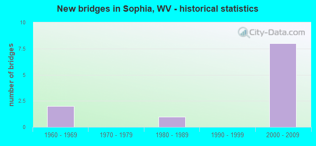
- New bridges - historical statistics
- 21960-1969
- 11980-1989
- 82000-2009


- Bridge Condition - Deck
- 14.3%Good
- 14.3%Satisfactory
- 42.9%Fair
- 28.6%Poor

- Bridge Condition - Superstructure
- 14.3%Good
- 57.1%Fair
- 28.6%Poor

- Bridge Condition - Substructure
- 28.6%Satisfactory
- 42.9%Fair
- 28.6%Poor

- Bridge Condition - Channel
- 33.3%Good
- 66.7%Satisfactory
Find on map >> Show street view
Structure Number: 41A112, Location: 1.21 MI E OF WV 16 (Lat: 37.680889, Lng: -81.289500), Route carried "on" structure: County highway 3000, Year Built: 1985, Status: Open, Structure Length: 1.15m (3.77ft), Average Daily Traffic: 40 (year 2019), Truck Traffic: 6%, Average Future Daily Traffic: 74 (year 2039), Design Load: HS 20, Features Intersected: WINDING GULF, Facility Carried by Structure: CR 30
Minimum Vertical Clearance: 30+ m (98+ ft), Kilometerpoint: 1.947, Lanes on structure: 2, Owner: State Highway Agency, Approaching Roadway Width: 6.7m (22.0ft), Skew: 3 degrees, Material/Design: Prestressed concrete, Design/Construction: Box Beam or Girders - Multiple, Number Of Spans In Main Unit: 1, Length of Maximum Span: 10.4m (34.1ft), Curb-To-Curb Width: 7.0m (23.0ft), Out-to-Out Width: 7.3m (24.0ft)
Condition: Deck: Poor, Superstructure: Poor, Substructure: Fair, Channel: Satisfactory, Operating Rating: 78.0 metric tons, Method Used To Determine Operating Rating: Load Factor (LF), Inventory Rating: 46.3 metric tons, Method Used To Determine Inventory Rating: Load Factor (LF), Structural Evaluation: Meets minimum limits, Deck Geometry: Somewhat better than minimum adequacy, Waterway Adequacy: Somewhat better than minimum adequacy, Approach Roadway Alignment: Somewhat better than minimum adequacy, Length Of Structure Improvement: 1.15m (3.77ft), Designated Inspection Frequency: Every 24 months, Inspection Date: August 2021, Bridge Improvement Cost: $350,000, Roadway Improvement Cost: $100,000, Total Project Cost: $450,000 ( Estimate for 2021), Deck Structure Type: Other, Wearing Surface/Protective System: Wearing Surface: Bituminous, Deck Protection: Epoxy Coated Reinforcing
Find on map >> Show street view
Structure Number: 41A113, Location: 0.64 MI. WEST OF CR. 32 (Lat: 37.688339, Lng: -81.282750), Route carried "on" structure: County highway 3000, Year Built: 1968, Status: Open, Structure Length: 1.56m (5.12ft), Average Daily Traffic: 200 (year 2018), Truck Traffic: 5%, Average Future Daily Traffic: 252 (year 2038), Features Intersected: WINDING GULF, Facility Carried by Structure: COUNTY ROUTE 30
Minimum Vertical Clearance: 30+ m (98+ ft), Kilometerpoint: 2.913, Lanes on structure: 2, Owner: State Highway Agency, Approaching Roadway Width: 6.7m (22.0ft), Material/Design: Steel, Design/Construction: Stringer/Multi-beam, Number Of Spans In Main Unit: 2, Length of Maximum Span: 7.1m (23.3ft), Curb or Sidewalk Widths: Left: 0.4m (1.3ft), Right: 0.4m (1.3ft), Curb-To-Curb Width: 7.9m (25.9ft), Out-to-Out Width: 9.8m (32.2ft)
Condition: Deck: Poor, Superstructure: Fair, Substructure: Poor, Channel: Satisfactory, Operating Rating: 88.9 metric tons, Method Used To Determine Operating Rating: Load Factor (LF), Inventory Rating: 54.4 metric tons, Method Used To Determine Inventory Rating: Load Factor (LF), Structural Evaluation: Meets minimum limits, Deck Geometry: Somewhat better than minimum adequacy, Waterway Adequacy: Equal to present minimum criteria, Approach Roadway Alignment: Meets minimum limits, Length Of Structure Improvement: 1.56m (5.12ft), Designated Inspection Frequency: Every 24 months, Other Special Inspection Frequency: Every 12 months, Inspection Date: Febuary 2020, Other Special Inspection Date: Febuary 2021, Bridge Improvement Cost: $1,200,000, Roadway Improvement Cost: $100,000, Total Project Cost: $1,300,000 ( Estimate for 2021), Deck Structure Type: Concrete Cast-file-Place, Wearing Surface/Protective System: Wearing Surface: Monolithic Concrete
Find on map >> Show street view
Structure Number: 41A294, Location: 0.58 MILE S OF WV 16 (Lat: 37.718819, Lng: -81.254061), Route carried "on" structure: State highway 12100, Year Built: 2004, Status: Open, Structure Length: 7.26m (23.82ft), Average Daily Traffic: 3,900 (year 2018), Truck Traffic: 5%, Average Future Daily Traffic: 4,914 (year 2038), Design Load: HL 93, Features Intersected: WV 54, Facility Carried by Structure: WV ROUTE 121
Minimum Vertical Clearance: 30+ m (98+ ft), Kilometerpoint: 6.196, Lanes on structure: 2, Lanes under structure: 5, Base Highway Network: Yes, Owner: State Highway Agency, Approaching Roadway Width: 10.4m (34.1ft), Skew: 1 degrees, Material/Design: Prestressed concrete continuous, Design/Construction: Stringer/Multi-beam, Number Of Spans In Main Unit: 1, Number Of Approach Spans: 2, Length of Maximum Span: 41.1m (134.8ft), Curb-To-Curb Width: 12.7m (41.7ft), Out-to-Out Width: 13.6m (44.6ft)
Condition: Deck: Good, Superstructure: Fair, Substructure: Satisfactory, Operating Rating: 44.4 metric tons, Method Used To Determine Operating Rating: Load and Resistance Factor (LRFR), Inventory Rating: 35.4 metric tons, Method Used To Determine Inventory Rating: Load and Resistance Factor (LRFR), Structural Evaluation: Somewhat better than minimum adequacy, Deck Geometry: Better than present minimum criteria, Underclear: Equal to present minimum criteria, Approach Roadway Alignment: Equal to present desirable criteria, Designated Inspection Frequency: Every 24 months, Inspection Date: June 2020, Deck Structure Type: Concrete Cast-file-Place, Wearing Surface/Protective System: Wearing Surface: Latex Concrete, Deck Protection: Epoxy Coated Reinforcing
Find on map >> Show street view
Structure Number: 41A295, Location: 0.58 MILE S OF WV 16 (Lat: 37.718839, Lng: -81.254561), Route carried "on" structure: State highway 12100, Year Built: 2004, Status: Open, Structure Length: 7.26m (23.82ft), Average Daily Traffic: 3,900 (year 2018), Truck Traffic: 5%, Average Future Daily Traffic: 4,914 (year 2038), Design Load: HL 93, Features Intersected: WV 54, Facility Carried by Structure: WV ROUTE 121
Minimum Vertical Clearance: 30+ m (98+ ft), Kilometerpoint: 6.196, Lanes on structure: 2, Lanes under structure: 5, Base Highway Network: Yes, Owner: State Highway Agency, Approaching Roadway Width: 12.2m (40.0ft), Skew: 1 degrees, Material/Design: Prestressed concrete continuous, Design/Construction: Stringer/Multi-beam, Number Of Spans In Main Unit: 1, Number Of Approach Spans: 2, Length of Maximum Span: 41.1m (134.8ft), Curb-To-Curb Width: 12.7m (41.7ft), Out-to-Out Width: 13.6m (44.6ft)
Condition: Deck: Satisfactory, Superstructure: Fair, Substructure: Satisfactory, Operating Rating: 44.4 metric tons, Method Used To Determine Operating Rating: Load and Resistance Factor (LRFR), Inventory Rating: 35.4 metric tons, Method Used To Determine Inventory Rating: Load and Resistance Factor (LRFR), Structural Evaluation: Somewhat better than minimum adequacy, Deck Geometry: Better than present minimum criteria, Underclear: Equal to present minimum criteria, Approach Roadway Alignment: Equal to present desirable criteria, Designated Inspection Frequency: Every 24 months, Inspection Date: June 2020, Deck Structure Type: Concrete Cast-file-Place, Wearing Surface/Protective System: Wearing Surface: Latex Concrete, Deck Protection: Epoxy Coated Reinforcing
Find on map >> Show street view
Structure Number: 41A296, Location: 0.33 MILE S OF WV 16 (Lat: 37.721939, Lng: -81.251939), Route carried "on" structure: State highway 12100, Year Built: 2004, Status: Open, Structure Length: 4.13m (13.55ft), Average Daily Traffic: 3,900 (year 2018), Truck Traffic: 5%, Average Future Daily Traffic: 4,914 (year 2038), Design Load: HL 93, Features Intersected: WV 121, Facility Carried by Structure: WV 121
Minimum Vertical Clearance: 30+ m (98+ ft), Kilometerpoint: 6.598, Lanes on structure: 3, Lanes under structure: 1, Base Highway Network: Yes, Owner: State Highway Agency, Approaching Roadway Width: 10.4m (34.1ft), Skew: 5 degrees, Material/Design: Steel, Design/Construction: Stringer/Multi-beam, Number Of Spans In Main Unit: 1, Length of Maximum Span: 39.7m (130.2ft), Curb-To-Curb Width: 17.2m (56.4ft), Out-to-Out Width: 17.9m (58.7ft)
Condition: Deck: Fair, Superstructure: Fair, Substructure: Fair, Operating Rating: 68.0 metric tons, Method Used To Determine Operating Rating: Load and Resistance Factor (LRFR), Inventory Rating: 40.8 metric tons, Method Used To Determine Inventory Rating: Load and Resistance Factor (LRFR), Structural Evaluation: Somewhat better than minimum adequacy, Deck Geometry: Superior to present desirable criteria, Underclear: Somewhat better than minimum adequacy, Approach Roadway Alignment: Better than present minimum criteria, Designated Inspection Frequency: Every 24 months, Inspection Date: August 2020, Deck Structure Type: Concrete Cast-file-Place, Wearing Surface/Protective System: Wearing Surface: Latex Concrete, Deck Protection: Epoxy Coated Reinforcing
Find on map >> Show street view
Structure Number: 41A297, Location: 0.33 MILE S OF WV 16 (Lat: 37.722461, Lng: -81.251981), Route carried "on" structure: State highway 12100, Year Built: 2004, Status: Open, Structure Length: 4.63m (15.19ft), Average Daily Traffic: 3,900 (year 2018), Truck Traffic: 5%, Average Future Daily Traffic: 4,914 (year 2038), Design Load: HL 93, Features Intersected: WV16 Ramp, Facility Carried by Structure: WV 121
Minimum Vertical Clearance: 30+ m (98+ ft), Kilometerpoint: 6.598, Lanes on structure: 2, Lanes under structure: 1, Base Highway Network: Yes, Owner: State Highway Agency, Approaching Roadway Width: 10.4m (34.1ft), Skew: 5 degrees, Material/Design: Steel, Design/Construction: Stringer/Multi-beam, Number Of Spans In Main Unit: 1, Length of Maximum Span: 44.7m (146.7ft), Curb-To-Curb Width: 12.6m (41.3ft), Out-to-Out Width: 13.6m (44.6ft)
Condition: Deck: Fair, Superstructure: Good, Substructure: Fair, Operating Rating: 44.4 metric tons, Method Used To Determine Operating Rating: Load and Resistance Factor (LRFR), Inventory Rating: 34.5 metric tons, Method Used To Determine Inventory Rating: Load and Resistance Factor (LRFR), Structural Evaluation: Somewhat better than minimum adequacy, Deck Geometry: Better than present minimum criteria, Underclear: Meets minimum limits, Approach Roadway Alignment: Better than present minimum criteria, Designated Inspection Frequency: Every 24 months, Inspection Date: July 2020, Deck Structure Type: Concrete Cast-file-Place, Wearing Surface/Protective System: Wearing Surface: Latex Concrete, Deck Protection: Epoxy Coated Reinforcing
Find on map >> Show street view
Structure Number: 41A324, Location: 0.08 Mi. South of Co. 30 (Lat: 37.679961, Lng: -81.289831), Route carried "on" structure: Other road 90265, Year Built: 1965, Status: Posted for load, Structure Length: 1.30m (4.27ft), Average Daily Traffic: 30 (year 2019), Truck Traffic: 7%, Average Future Daily Traffic: 38 (year 2039), Features Intersected: Winding Gulf, Facility Carried by Structure: Harp Route 902/65
Minimum Vertical Clearance: 30+ m (98+ ft), Kilometerpoint: 0.129, Lanes on structure: 1, Owner: State Highway Agency, Approaching Roadway Width: 3.7m (12.1ft), Material/Design: Wood or Timber, Design/Construction: Stringer/Multi-beam, Number Of Spans In Main Unit: 1, Number Of Approach Spans: 1, Length of Maximum Span: 6.8m (22.3ft), Curb or Sidewalk Widths: Left: 0.2m (0.7ft), Right: 0.2m (0.7ft), Curb-To-Curb Width: 3.3m (10.8ft), Out-to-Out Width: 3.7m (12.1ft)
Condition: Deck: Fair, Superstructure: Poor, Substructure: Poor, Channel: Good, Operating Rating: 10.9 metric tons, Method Used To Determine Operating Rating: Allowable Stress (AS), Inventory Rating: 6.3 metric tons, Method Used To Determine Inventory Rating: Allowable Stress (AS), Structural Evaluation: High priority of replacement, Deck Geometry: High priority of replacement, Waterway Adequacy: Equal to present minimum criteria, Approach Roadway Alignment: Somewhat better than minimum adequacy, Bridge Posting: Required (Relationship of Operating Rating to Maximum Legal Load: > 39.9% below), Length Of Structure Improvement: 1.37m (4.49ft), Designated Inspection Frequency: Every 24 months, Inspection Date: May 2021, Bridge Improvement Cost: $350,000, Roadway Improvement Cost: $50,000, Total Project Cost: $400,000 ( Estimate for 2020), Deck Structure Type: Wood or Timber
Find on map >> Show street view
Structure Number: 41A294, Location: 0.58 MILE S OF WV 16 (Lat: 37.718839, Lng: -81.254069), Route carried "under" structure: State highway 5400, Year Built: 2004, Structure Length: 0. m, Average Daily Traffic: 7,000 (year 0009), Truck Traffic: 6%, Features Intersected: WV 54, Facility Carried by Structure: WV ROUTE 121
Minimum Vertical Clearance: 6.99m (22.93ft), Kilometerpoint: 16.496, Lanes on structure: 2, Lanes under structure: 5, Length of Maximum Span: 41.1m (134.8ft)
Find on map >> Show street view
Structure Number: 41A295, Location: 0.58 MILE S OF WV 16 (Lat: 37.718800, Lng: -81.254339), Route carried "under" structure: State highway 5400, Year Built: 2004, Structure Length: 0. m, Average Daily Traffic: 7,000 (year 0009), Truck Traffic: 6%, Features Intersected: WV 54, Facility Carried by Structure: WV ROUTE 121
Minimum Vertical Clearance: 8.33m (27.33ft), Kilometerpoint: 16.560, Lanes on structure: 2, Lanes under structure: 5, Length of Maximum Span: 41.1m (134.8ft)
Find on map >> Show street view
Structure Number: 41A296, Location: 0.33 MILE S OF WV 16 (Lat: 37.721950, Lng: -81.251961), Route carried "under" structure: Ramp State highway 1600, Year Built: 2004, Structure Length: 0. m, Average Daily Traffic: 1,000 (year 0009), Truck Traffic: 6%, Features Intersected: WV 121, Facility Carried by Structure: WV 121
Minimum Vertical Clearance: 5.13m (16.83ft), Kilometerpoint: 0.322, Lanes on structure: 3, Lanes under structure: 1, Length of Maximum Span: 39.7m (130.2ft)
Find on map >> Show street view
Structure Number: 41A297, Location: 0.33 MILE S OF WV 16 (Lat: 37.722261, Lng: -81.251981), Route carried "under" structure: Ramp State highway 1600, Year Built: 2004, Structure Length: 0. m, Average Daily Traffic: 1,000 (year 0009), Truck Traffic: 6%, Features Intersected: WV16 Ramp, Facility Carried by Structure: WV 121
Minimum Vertical Clearance: 6.30m (20.67ft), Kilometerpoint: 0.322, Lanes on structure: 2, Lanes under structure: 1, Length of Maximum Span: 44.7m (146.7ft)