Bridge Statistics for Socorro, Texas (TX)
Condition, Traffic, Stress, Structural Evaluation, Project Costs
- National Bridge Inventory (NBI) Statistics
- 40Number of bridges
- 279ft / 85.0mTotal length
- $26,000Total costs
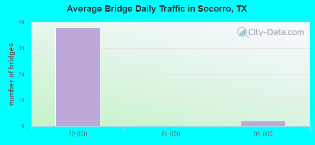
- 632,975Total average daily traffic
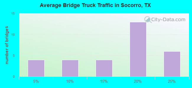
- 97,042Total average daily truck traffic
- National Bridge Inventory (NBI) Registered Bridges for Socorro
- No street view available for this location
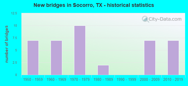
- New bridges - historical statistics
- 71950-1959
- 71960-1969
- 101970-1979
- 21980-1989
- 72000-2009
- 72010-2019
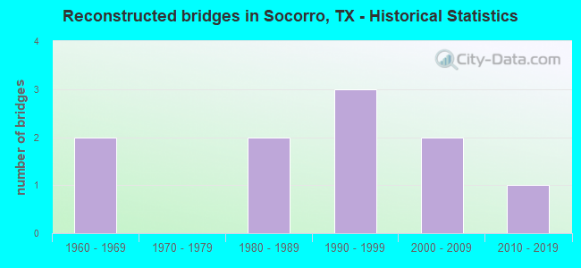
- Reconstructed bridges - Historical Statistics
- 21960-1969
- 01970-1979
- 21980-1989
- 31990-1999
- 22000-2009
- 12010-2019
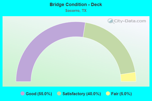
- Bridge Condition - Deck
- 55.0%Good
- 40.0%Satisfactory
- 5.0%Fair
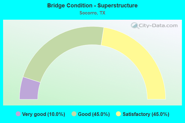
- Bridge Condition - Superstructure
- 10.0%Very good
- 45.0%Good
- 45.0%Satisfactory
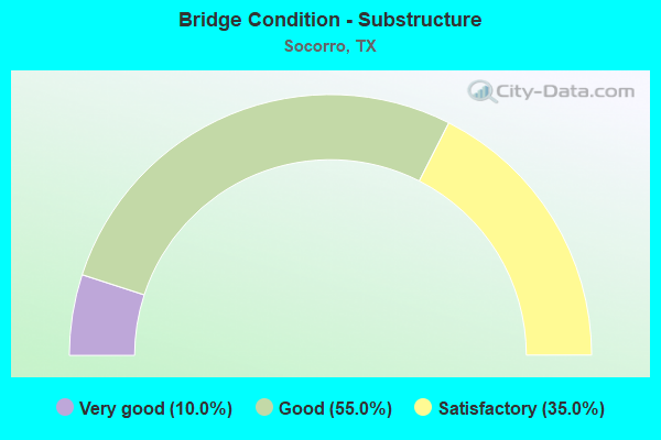
- Bridge Condition - Substructure
- 10.0%Very good
- 55.0%Good
- 35.0%Satisfactory
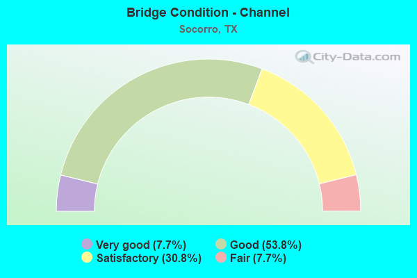
- Bridge Condition - Channel
- 7.7%Very good
- 53.8%Good
- 30.8%Satisfactory
- 7.7%Fair
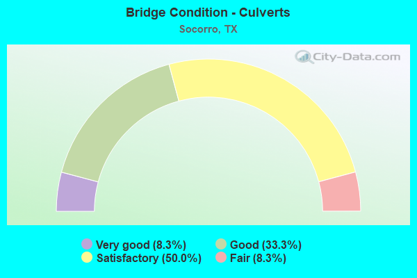
- Bridge Condition - Culverts
- 8.3%Very good
- 33.3%Good
- 50.0%Satisfactory
- 8.3%Fair
Find on map >> Show street view
Structure Number: 240720000214082, Location: 5.1 MI E OF SH 20 (Lat: 31.625744, Lng: -106.289875), Route carried "on" structure: State highway 258, Year Built: 1953, Year Reconstructed: 1988, Status: Open, Structure Length: 1.52m (4.99ft), Average Daily Traffic: 16,433 (year 2017), Truck Traffic: 5%, Average Future Daily Traffic: 22,020 (year 2033), Design Load: H 15, Features Intersected: FRANKLIN CANAL FEEDER
Minimum Vertical Clearance: 30+ m (98+ ft), Kilometerpoint: 8.222, Lanes on structure: 2, Owner: State Highway Agency, Approaching Roadway Width: 9.8m (32.2ft), Skew: 3 degrees, Material/Design: Concrete, Design/Construction: Slab, Number Of Spans In Main Unit: 2, Length of Maximum Span: 7.6m (24.9ft), Curb-To-Curb Width: 12.1m (39.7ft), Out-to-Out Width: 12.8m (42.0ft)
Condition: Deck: Good, Superstructure: Good, Substructure: Good, Channel: Good, Operating Rating: 35.4 metric tons, Method Used To Determine Operating Rating: Load Factor (LF), Inventory Rating: 20.9 metric tons, Method Used To Determine Inventory Rating: Load Factor (LF), Structural Evaluation: Somewhat better than minimum adequacy, Deck Geometry: Somewhat better than minimum adequacy, Waterway Adequacy: Equal to present minimum criteria, Approach Roadway Alignment: Equal to present desirable criteria, Length Of Structure Improvement: 1.52m (4.99ft), Designated Inspection Frequency: Every 24 months, Inspection Date: June 2021, Deck Structure Type: Concrete Cast-file-Place, Wearing Surface/Protective System: Wearing Surface: Bituminous
Find on map >> Show street view
Structure Number: 240720212104045, Location: 2.2 MI E OF LOOP 375 (Lat: 31.678472, Lng: -106.258447), Route carried "on" structure: Interstate 10, Year Built: 1958, Year Reconstructed: 1969, Status: Open, Structure Length: 0.70m (2.30ft), Average Daily Traffic: 24,485 (year 2020), Truck Traffic: 15%, Average Future Daily Traffic: 38,900 (year 2033), Design Load: HS 20, Features Intersected: DRAIN
Minimum Vertical Clearance: 30+ m (98+ ft), Kilometerpoint: 59.488, Lanes on structure: 8, Owner: State Highway Agency, Approaching Roadway Width: 44.2m (145.0ft), Skew: 20 degrees, Material/Design: Concrete, Design/Construction: Culvert, Number Of Spans In Main Unit: 3, Length of Maximum Span: 2.1m (6.9ft)
Condition: Channel: Good, Culverts: Good, Operating Rating: 39.9 metric tons, Method Used To Determine Operating Rating: Load Factor (LF), Inventory Rating: 23.6 metric tons, Method Used To Determine Inventory Rating: Load Factor (LF), Structural Evaluation: Somewhat better than minimum adequacy, Waterway Adequacy: Equal to present minimum criteria, Approach Roadway Alignment: Equal to present desirable criteria, Designated Inspection Frequency: Every 24 months, Inspection Date: June 2021
Find on map >> Show street view
Structure Number: 240720212104046, Location: 2.6 MI E OF LOOP 375 (Lat: 31.674111, Lng: -106.253617), Route carried "on" structure: Interstate 10, Year Built: 1958, Year Reconstructed: 1969, Status: Open, Structure Length: 1.31m (4.30ft), Average Daily Traffic: 24,485 (year 2020), Truck Traffic: 15%, Average Future Daily Traffic: 38,900 (year 2033), Design Load: HS 20, Features Intersected: DRAIN
Minimum Vertical Clearance: 30+ m (98+ ft), Kilometerpoint: 60.138, Lanes on structure: 9, Base Highway Network: Yes, Owner: State Highway Agency, Approaching Roadway Width: 44.2m (145.0ft), Skew: 20 degrees, Material/Design: Concrete, Design/Construction: Culvert, Number Of Spans In Main Unit: 5, Length of Maximum Span: 2.4m (7.9ft)
Condition: Channel: Fair, Culverts: Satisfactory, Operating Rating: 39.9 metric tons, Method Used To Determine Operating Rating: Load Factor (LF), Inventory Rating: 23.6 metric tons, Method Used To Determine Inventory Rating: Load Factor (LF), Structural Evaluation: Somewhat better than minimum adequacy, Waterway Adequacy: Equal to present minimum criteria, Approach Roadway Alignment: Equal to present desirable criteria, Designated Inspection Frequency: Every 24 months, Inspection Date: July 2021
Find on map >> Show street view
Structure Number: 240720212104049, Location: 5.5 MI E OF LP 375 (Lat: 31.641089, Lng: -106.225644), Route carried "on" structure: Interstate 10, Year Built: 1958, Status: Open, Structure Length: 4.88m (16.01ft), Average Daily Traffic: 15,620 (year 2013), Truck Traffic: 15%, Average Future Daily Traffic: 21,870 (year 2033), Design Load: HS 20, Features Intersected: DRAIN & TURNAROUNDS
Minimum Vertical Clearance: 30+ m (98+ ft), Kilometerpoint: 64.709, Lanes on structure: 2, Lanes under structure: 2, Base Highway Network: Yes, Owner: State Highway Agency, Approaching Roadway Width: 12.2m (40.0ft), Material/Design: Concrete continuous, Design/Construction: Slab, Number Of Spans In Main Unit: 6, Length of Maximum Span: 9.1m (29.9ft), Curb-To-Curb Width: 13.8m (45.3ft), Out-to-Out Width: 14.6m (47.9ft)
Condition: Deck: Satisfactory, Superstructure: Satisfactory, Substructure: Satisfactory, Channel: Satisfactory, Operating Rating: 45.4 metric tons, Method Used To Determine Operating Rating: Load Factor (LF), Inventory Rating: 27.2 metric tons, Method Used To Determine Inventory Rating: Load Factor (LF), Structural Evaluation: Equal to present minimum criteria, Deck Geometry: Superior to present desirable criteria, Underclear: High priority of corrective action, Waterway Adequacy: Superior to present desirable criteria, Approach Roadway Alignment: Equal to present desirable criteria, Designated Inspection Frequency: Every 24 months, Inspection Date: July 2021, Deck Structure Type: Concrete Cast-file-Place, Wearing Surface/Protective System: Wearing Surface: Bituminous
Find on map >> Show street view
Structure Number: 24072021210405, Location: 1.8 MI W OF FM 1110 (Lat: 31.622411, Lng: -106.210625), Route carried "on" structure: Interstate 10, Year Built: 1958, Year Reconstructed: 1997, Status: Open, Structure Length: 0.67m (2.20ft), Average Daily Traffic: 30,850 (year 2020), Truck Traffic: 15%, Average Future Daily Traffic: 43,740 (year 2033), Features Intersected: DRAIN
Minimum Vertical Clearance: 30+ m (98+ ft), Kilometerpoint: 67.221, Lanes on structure: 4, Base Highway Network: Yes, Owner: State Highway Agency, Approaching Roadway Width: 24.7m (81.0ft), Skew: 20 degrees, Material/Design: Concrete, Design/Construction: Culvert, Number Of Spans In Main Unit: 2, Length of Maximum Span: 3.0m (9.8ft)
Condition: Channel: Good, Culverts: Satisfactory, Operating Rating: 39.9 metric tons, Method Used To Determine Operating Rating: Load Factor (LF), Inventory Rating: 23.6 metric tons, Method Used To Determine Inventory Rating: Load Factor (LF), Structural Evaluation: Somewhat better than minimum adequacy, Waterway Adequacy: Equal to present minimum criteria, Approach Roadway Alignment: Equal to present desirable criteria, Designated Inspection Frequency: Every 24 months, Inspection Date: July 2021
Find on map >> Show street view
Structure Number: 240720212104051, Location: 0.8 MI W OF FM 1110 (Lat: 31.609842, Lng: -106.200883), Route carried "on" structure: Interstate 10, Year Built: 1960, Year Reconstructed: 1997, Status: Open, Structure Length: 0.94m (3.08ft), Average Daily Traffic: 30,850 (year 2020), Truck Traffic: 15%, Average Future Daily Traffic: 43,740 (year 2033), Features Intersected: DRAIN
Minimum Vertical Clearance: 30+ m (98+ ft), Kilometerpoint: 68.857, Lanes on structure: 4, Base Highway Network: Yes, Owner: State Highway Agency, Approaching Roadway Width: 24.7m (81.0ft), Skew: 20 degrees, Material/Design: Concrete, Design/Construction: Culvert, Number Of Spans In Main Unit: 4, Length of Maximum Span: 2.1m (6.9ft)
Condition: Channel: Good, Culverts: Fair, Operating Rating: 39.9 metric tons, Method Used To Determine Operating Rating: Load Factor (LF), Inventory Rating: 23.6 metric tons, Method Used To Determine Inventory Rating: Load Factor (LF), Structural Evaluation: Somewhat better than minimum adequacy, Waterway Adequacy: Equal to present minimum criteria, Approach Roadway Alignment: Equal to present desirable criteria, Designated Inspection Frequency: Every 24 months, Inspection Date: July 2021
Find on map >> Show street view
Structure Number: 240720212104052, Location: 6.8 MI W OF FM 793 (Lat: 31.601833, Lng: -106.194844), Route carried "on" structure: Interstate 10, Year Built: 1958, Year Reconstructed: 2015, Status: Open, Structure Length: 1.01m (3.31ft), Average Daily Traffic: 30,850 (year 2020), Truck Traffic: 15%, Average Future Daily Traffic: 43,740 (year 2033), Design Load: HS 20, Features Intersected: DRAIN
Minimum Vertical Clearance: 30+ m (98+ ft), Kilometerpoint: 69.952, Lanes on structure: 8, Owner: State Highway Agency, Approaching Roadway Width: 43.9m (144.0ft), Skew: 29 degrees, Material/Design: Concrete, Design/Construction: Culvert, Number Of Spans In Main Unit: 3, Length of Maximum Span: 3.0m (9.8ft)
Condition: Channel: Good, Culverts: Satisfactory, Operating Rating: 39.9 metric tons, Method Used To Determine Operating Rating: Load Factor (LF), Inventory Rating: 23.6 metric tons, Method Used To Determine Inventory Rating: Load Factor (LF), Structural Evaluation: Somewhat better than minimum adequacy, Waterway Adequacy: Superior to present desirable criteria, Approach Roadway Alignment: Equal to present desirable criteria, Designated Inspection Frequency: Every 24 months, Inspection Date: June 2021
Find on map >> Show street view
Structure Number: 240720212104053, Location: 0.2 MI SE OF FM 1110 (Lat: 31.597606, Lng: -106.191564), Route carried "on" structure: Interstate 10, Year Built: 1960, Year Reconstructed: 1985, Status: Open, Structure Length: 0.67m (2.20ft), Average Daily Traffic: 25,045 (year 2020), Truck Traffic: 14%, Average Future Daily Traffic: 32,580 (year 2033), Design Load: HS 20, Features Intersected: DRAIN
Minimum Vertical Clearance: 30+ m (98+ ft), Kilometerpoint: 70.499, Lanes on structure: 8, Owner: State Highway Agency, Approaching Roadway Width: 43.9m (144.0ft), Skew: 20 degrees, Material/Design: Concrete, Design/Construction: Culvert, Number Of Spans In Main Unit: 2, Length of Maximum Span: 3.0m (9.8ft)
Condition: Channel: Satisfactory, Culverts: Good, Operating Rating: 39.9 metric tons, Method Used To Determine Operating Rating: Load Factor (LF), Inventory Rating: 23.6 metric tons, Method Used To Determine Inventory Rating: Load Factor (LF), Structural Evaluation: Somewhat better than minimum adequacy, Waterway Adequacy: Equal to present minimum criteria, Approach Roadway Alignment: Equal to present desirable criteria, Designated Inspection Frequency: Every 24 months, Inspection Date: June 2021
Find on map >> Show street view
Structure Number: 240720212104054, Location: 6.1 MI W OF FM 793 (Lat: 31.592436, Lng: -106.187406), Route carried "on" structure: Interstate 10, Year Built: 1960, Year Reconstructed: 1997, Status: Open, Structure Length: 0.67m (2.20ft), Average Daily Traffic: 25,045 (year 2020), Truck Traffic: 14%, Average Future Daily Traffic: 32,580 (year 2033), Features Intersected: DRAIN
Minimum Vertical Clearance: 30+ m (98+ ft), Kilometerpoint: 71.176, Lanes on structure: 4, Base Highway Network: Yes, Owner: State Highway Agency, Approaching Roadway Width: 24.4m (80.1ft), Skew: 20 degrees, Material/Design: Concrete, Design/Construction: Culvert, Number Of Spans In Main Unit: 2, Length of Maximum Span: 3.0m (9.8ft)
Condition: Channel: Satisfactory, Culverts: Good, Operating Rating: 39.9 metric tons, Method Used To Determine Operating Rating: Load Factor (LF), Inventory Rating: 23.6 metric tons, Method Used To Determine Inventory Rating: Load Factor (LF), Structural Evaluation: Somewhat better than minimum adequacy, Waterway Adequacy: Equal to present minimum criteria, Approach Roadway Alignment: Equal to present desirable criteria, Designated Inspection Frequency: Every 24 months, Inspection Date: July 2021
Find on map >> Show street view
Structure Number: 240720212104121, Location: 5.5 MI E OF LP 375 (Lat: 31.640933, Lng: -106.225044), Route carried "on" structure: Interstate 10, Year Built: 1960, Status: Open, Structure Length: 4.88m (16.01ft), Average Daily Traffic: 15,620 (year 2013), Truck Traffic: 15%, Average Future Daily Traffic: 21,870 (year 2033), Design Load: HS 20, Features Intersected: DRAIN & TURNAROUNDS
Minimum Vertical Clearance: 30+ m (98+ ft), Kilometerpoint: 64.709, Lanes on structure: 2, Lanes under structure: 2, Base Highway Network: Yes, Owner: State Highway Agency, Approaching Roadway Width: 12.2m (40.0ft), Material/Design: Concrete continuous, Design/Construction: Slab, Number Of Spans In Main Unit: 6, Length of Maximum Span: 9.1m (29.9ft), Curb-To-Curb Width: 12.2m (40.0ft), Out-to-Out Width: 12.8m (42.0ft)
Condition: Deck: Satisfactory, Superstructure: Satisfactory, Substructure: Satisfactory, Channel: Good, Operating Rating: 46.3 metric tons, Method Used To Determine Operating Rating: Load Factor (LF), Inventory Rating: 27.2 metric tons, Method Used To Determine Inventory Rating: Load Factor (LF), Structural Evaluation: Equal to present minimum criteria, Deck Geometry: Better than present minimum criteria, Underclear: High priority of corrective action, Waterway Adequacy: Superior to present desirable criteria, Approach Roadway Alignment: Equal to present desirable criteria, Designated Inspection Frequency: Every 24 months, Inspection Date: July 2021, Deck Structure Type: Concrete Cast-file-Place, Wearing Surface/Protective System: Wearing Surface: Bituminous
Find on map >> Show street view
Structure Number: 240720212104213, Location: JCT FM 1281 & IH 10 (Lat: 31.658653, Lng: -106.240244), Route carried "on" structure: ServiceInterstate 10, Year Built: 1969, Status: Open, Structure Length: 1.52m (4.99ft), Average Daily Traffic: 3,970 (year 2013), Truck Traffic: 16%, Average Future Daily Traffic: 5,560 (year 2033), Design Load: HS 20, Features Intersected: DRAIN
Minimum Vertical Clearance: 30+ m (98+ ft), Kilometerpoint: 62.294, Lanes on structure: 2, Base Highway Network: Yes, Owner: State Highway Agency, Approaching Roadway Width: 15.9m (52.2ft), Skew: 3 degrees, Material/Design: Concrete, Design/Construction: Culvert, Number Of Spans In Main Unit: 5, Length of Maximum Span: 2.4m (7.9ft)
Condition: Channel: Good, Culverts: Satisfactory, Operating Rating: 39.9 metric tons, Method Used To Determine Operating Rating: Load Factor (LF), Inventory Rating: 23.6 metric tons, Method Used To Determine Inventory Rating: Load Factor (LF), Structural Evaluation: Equal to present minimum criteria, Waterway Adequacy: Equal to present minimum criteria, Approach Roadway Alignment: Equal to present desirable criteria, Designated Inspection Frequency: Every 24 months, Inspection Date: July 2021
Find on map >> Show street view
Structure Number: 240720212104233, Location: FM 1281 & IH 10 (Lat: 31.659475, Lng: -106.240086), Route carried "on" structure: State highway 1281, Year Built: 1981, Year Reconstructed: 2009, Status: Open, Structure Length: 7.62m (25.00ft), Average Daily Traffic: 22,870 (year 2013), Truck Traffic: 6%, Average Future Daily Traffic: 32,020 (year 2033), Design Load: HS 20, Features Intersected: IH 10
Minimum Vertical Clearance: 30+ m (98+ ft), Kilometerpoint: 4.345, Lanes on structure: 6, Lanes under structure: 6, Owner: State Highway Agency, Approaching Roadway Width: 25.6m (84.0ft), Material/Design: Prestressed concrete, Design/Construction: Box Beam or Girders - Multiple, Number Of Spans In Main Unit: 2, Number Of Approach Spans: 2, Length of Maximum Span: 25.9m (85.0ft), Curb or Sidewalk Widths: Left: 2.7m (8.9ft), Right: 2.7m (8.9ft), Curb-To-Curb Width: 25.6m (84.0ft), Out-to-Out Width: 31.7m (104.0ft)
Condition: Deck: Satisfactory, Superstructure: Good, Substructure: Satisfactory, Operating Rating: 54.4 metric tons, Method Used To Determine Operating Rating: Assigned rating based on Load Factor Design (LFD) reported in metric tons, Inventory Rating: 32.7 metric tons, Method Used To Determine Inventory Rating: Assigned rating based on Load Factor Design (LFD) reported in metric tons, Structural Evaluation: Equal to present minimum criteria, Deck Geometry: Somewhat better than minimum adequacy, Underclear: Better than present minimum criteria, Approach Roadway Alignment: Equal to present desirable criteria, Designated Inspection Frequency: Every 24 months, Inspection Date: June 2021, Deck Structure Type: Other, Wearing Surface/Protective System: Wearing Surface: Monolithic Concrete
Find on map >> Show street view
Structure Number: 240720212104259, Location: 1.44 MI E OF LP 375 (Lat: 31.686150, Lng: -106.267378), Route carried "on" structure: Interstate 10, Year Built: 2003, Status: Open, Structure Length: 8.66m (28.41ft), Average Daily Traffic: 12,467 (year 2017), Truck Traffic: 15%, Average Future Daily Traffic: 19,450 (year 2033), Design Load: HS 25 or greater, Features Intersected: EASTLAKE BLVD
Minimum Vertical Clearance: 30+ m (98+ ft), Kilometerpoint: 58.307, Lanes on structure: 2, Lanes under structure: 9, Base Highway Network: Yes, Owner: State Highway Agency, Approaching Roadway Width: 12.2m (40.0ft), Skew: 30 degrees, Material/Design: Prestressed concrete, Design/Construction: Stringer/Multi-beam, Number Of Spans In Main Unit: 1, Number Of Approach Spans: 2, Length of Maximum Span: 34.7m (113.8ft), Curb-To-Curb Width: 17.1m (56.1ft), Out-to-Out Width: 17.8m (58.4ft)
Condition: Deck: Good, Superstructure: Good, Substructure: Good, Operating Rating: 68.0 metric tons, Method Used To Determine Operating Rating: Assigned rating based on Load Factor Design (LFD) reported in metric tons, Inventory Rating: 40.8 metric tons, Method Used To Determine Inventory Rating: Assigned rating based on Load Factor Design (LFD) reported in metric tons, Structural Evaluation: Better than present minimum criteria, Deck Geometry: Superior to present desirable criteria, Underclear: Meets minimum limits, Approach Roadway Alignment: Equal to present desirable criteria, Designated Inspection Frequency: Every 24 months, Inspection Date: July 2021, Deck Structure Type: Concrete Cast-file-Place
Find on map >> Show street view
Structure Number: 24072021210426, Location: 1.44 MI E OF LP 375 (Lat: 31.686194, Lng: -106.267225), Route carried "on" structure: Interstate 10, Year Built: 2003, Status: Open, Structure Length: 8.66m (28.41ft), Average Daily Traffic: 16,850 (year 2019), Truck Traffic: 15%, Average Future Daily Traffic: 19,450 (year 2033), Design Load: HS 25 or greater, Features Intersected: EASTLAKE BLVD
Minimum Vertical Clearance: 30+ m (98+ ft), Kilometerpoint: 58.307, Lanes on structure: 2, Lanes under structure: 9, Base Highway Network: Yes, Owner: State Highway Agency, Approaching Roadway Width: 12.2m (40.0ft), Skew: 30 degrees, Material/Design: Prestressed concrete, Design/Construction: Stringer/Multi-beam, Number Of Spans In Main Unit: 1, Number Of Approach Spans: 2, Length of Maximum Span: 34.7m (113.8ft), Curb-To-Curb Width: 17.1m (56.1ft), Out-to-Out Width: 17.8m (58.4ft)
Condition: Deck: Satisfactory, Superstructure: Very good, Substructure: Good, Operating Rating: 68.0 metric tons, Method Used To Determine Operating Rating: Assigned rating based on Load Factor Design (LFD) reported in metric tons, Inventory Rating: 40.8 metric tons, Method Used To Determine Inventory Rating: Assigned rating based on Load Factor Design (LFD) reported in metric tons, Structural Evaluation: Better than present minimum criteria, Deck Geometry: Superior to present desirable criteria, Underclear: Meets minimum limits, Approach Roadway Alignment: Equal to present desirable criteria, Designated Inspection Frequency: Every 24 months, Inspection Date: July 2021, Deck Structure Type: Concrete Cast-file-Place
Find on map >> Show street view
Structure Number: 240720212104277, Location: 1.38 MI E OF LP 375 (Lat: 31.686558, Lng: -106.268336), Route carried "on" structure: Interstate 10, Year Built: 2003, Status: Open, Structure Length: 0.82m (2.69ft), Average Daily Traffic: 24,485 (year 2020), Truck Traffic: 24%, Average Future Daily Traffic: 93,010 (year 2031), Design Load: HS 20, Features Intersected: DRAIN
Minimum Vertical Clearance: 30+ m (98+ ft), Kilometerpoint: 58.216, Lanes on structure: 10, Owner: State Highway Agency, Approaching Roadway Width: 65.5m (214.9ft), Skew: 33 degrees, Material/Design: Concrete, Design/Construction: Culvert, Number Of Spans In Main Unit: 2, Length of Maximum Span: 3.0m (9.8ft)
Condition: Channel: Good, Culverts: Good, Operating Rating: 44.4 metric tons, Method Used To Determine Operating Rating: No rating analysis performed, Inventory Rating: 32.7 metric tons, Method Used To Determine Inventory Rating: No rating analysis performed, Structural Evaluation: Better than present minimum criteria, Waterway Adequacy: Equal to present minimum criteria, Approach Roadway Alignment: Equal to present desirable criteria, Designated Inspection Frequency: Every 48 months, Inspection Date: June 2021
Find on map >> Show street view
Structure Number: 240720212104283, Location: FM 1281 & IH 10 (Lat: 31.659753, Lng: -106.240347), Route carried "on" structure: ServiceState highway 1281, Year Built: 2009, Status: Open, Structure Length: 7.62m (25.00ft), Average Daily Traffic: 22,000 (year 2009), Average Future Daily Traffic: 30,800 (year 2027), Design Load: HS 25 or greater, Features Intersected: IH 10
Minimum Vertical Clearance: 30+ m (98+ ft), Kilometerpoint: 4.345, Lanes on structure: 1, Lanes under structure: 6, Base Highway Network: Yes, Owner: State Highway Agency, Approaching Roadway Width: 11.6m (38.1ft), Material/Design: Prestressed concrete, Design/Construction: Box Beam or Girders - Multiple, Number Of Spans In Main Unit: 2, Number Of Approach Spans: 2, Length of Maximum Span: 25.9m (85.0ft), Curb-To-Curb Width: 11.6m (38.1ft), Out-to-Out Width: 12.2m (40.0ft)
Condition: Deck: Satisfactory, Superstructure: Good, Substructure: Good, Operating Rating: 68.0 metric tons, Method Used To Determine Operating Rating: Assigned rating based on Load Factor Design (LFD) reported in metric tons, Inventory Rating: 40.8 metric tons, Method Used To Determine Inventory Rating: Assigned rating based on Load Factor Design (LFD) reported in metric tons, Structural Evaluation: Better than present minimum criteria, Deck Geometry: Somewhat better than minimum adequacy, Underclear: Better than present minimum criteria, Approach Roadway Alignment: Equal to present desirable criteria, Length Of Structure Improvement: 7.62m (25.00ft), Designated Inspection Frequency: Every 24 months, Inspection Date: June 2021, Bridge Improvement Cost: $19,000, Roadway Improvement Cost: $5,000, Total Project Cost: $24,000, Deck Structure Type: Concrete Cast-file-Place
Find on map >> Show street view
Structure Number: 240720212104285, Location: 4.0 MI E OF LP 375 (Lat: 31.653000, Lng: -106.234500), Route carried "on" structure: Interstate 10, Year Built: 1963, Year Reconstructed: 2009, Status: Open, Structure Length: 1.68m (5.51ft), Average Daily Traffic: 1,000 (year 2014), Truck Traffic: 20%, Average Future Daily Traffic: 3,000 (year 2032), Features Intersected: DRAINAGE DITCH
Minimum Vertical Clearance: 30+ m (98+ ft), Kilometerpoint: 6.437, Lanes on structure: 7, Base Highway Network: Yes, Owner: State Highway Agency, Approaching Roadway Width: 56.7m (186.0ft), Skew: 9 degrees, Material/Design: Concrete, Design/Construction: Culvert, Number Of Spans In Main Unit: 7, Length of Maximum Span: 1.5m (4.9ft), Curb-To-Curb Width: 12.3m (40.4ft), Out-to-Out Width: 97.5m (319.9ft)
Condition: Channel: Fair, Culverts: Satisfactory, Operating Rating: 32.7 metric tons, Method Used To Determine Operating Rating: Field evaluation and documented engineering judgment, Inventory Rating: 24.5 metric tons, Method Used To Determine Inventory Rating: Field evaluation and documented engineering judgment, Structural Evaluation: Equal to present minimum criteria, Deck Geometry: High priority of replacement, Waterway Adequacy: Meets minimum limits, Approach Roadway Alignment: Equal to present desirable criteria, Designated Inspection Frequency: Every 24 months, Inspection Date: July 2021, Deck Structure Type: Concrete Cast-file-Place, Wearing Surface/Protective System: Wearing Surface: Monolithic Concrete
Find on map >> Show street view
Structure Number: 240720212104286, Location: 4 MI E OF LP 375 (Lat: 31.652500, Lng: -106.234800), Route carried "on" structure: ServiceInterstate , Year Built: 2013, Status: Open, Structure Length: 1.62m (5.31ft), Average Daily Traffic: 1,000 (year 2014), Truck Traffic: 20%, Average Future Daily Traffic: 2,000 (year 2032), Features Intersected: DRAINAGE DITCH, Facility Carried by Structure: IH 10 EBFR
Minimum Vertical Clearance: 30+ m (98+ ft), Kilometerpoint: 6.437, Lanes on structure: 3, Base Highway Network: Yes, Owner: State Highway Agency, Approaching Roadway Width: 11.9m (39.0ft), Material/Design: Concrete, Design/Construction: Culvert, Number Of Spans In Main Unit: 7, Length of Maximum Span: 1.5m (4.9ft), Curb-To-Curb Width: 12.0m (39.4ft), Out-to-Out Width: 21.2m (69.6ft)
Condition: Channel: Satisfactory, Culverts: Satisfactory, Operating Rating: 32.7 metric tons, Method Used To Determine Operating Rating: Field evaluation and documented engineering judgment, Inventory Rating: 24.5 metric tons, Method Used To Determine Inventory Rating: Field evaluation and documented engineering judgment, Structural Evaluation: Equal to present minimum criteria, Deck Geometry: Meets minimum limits, Waterway Adequacy: Equal to present minimum criteria, Approach Roadway Alignment: Equal to present desirable criteria, Designated Inspection Frequency: Every 24 months, Inspection Date: July 2021, Deck Structure Type: Concrete Cast-file-Place, Wearing Surface/Protective System: Wearing Surface: Monolithic Concrete
Find on map >> Show street view
Structure Number: 240720212104301, Location: 6.7 MI. W. OF FM 793 (Lat: 31.600039, Lng: -106.194150), Route carried "on" structure: State highway 1110, Year Built: 2016, Status: Open, Structure Length: 7.01m (23.00ft), Average Daily Traffic: 10,700 (year 2014), Truck Traffic: 17%, Average Future Daily Traffic: 16,500 (year 2034), Design Load: HL 93, Features Intersected: IH 10
Minimum Vertical Clearance: 30+ m (98+ ft), Kilometerpoint: 9.917, Lanes on structure: 6, Lanes under structure: 4, Owner: State Highway Agency, Approaching Roadway Width: 25.6m (84.0ft), Material/Design: Prestressed concrete, Design/Construction: Stringer/Multi-beam, Number Of Spans In Main Unit: 2, Length of Maximum Span: 35.1m (115.2ft), Curb or Sidewalk Widths: Left: 1.8m (5.9ft), Right: 1.8m (5.9ft), Curb-To-Curb Width: 25.6m (84.0ft), Out-to-Out Width: 29.9m (98.1ft)
Condition: Deck: Good, Superstructure: Good, Substructure: Good, Operating Rating: 54.4 metric tons, Method Used To Determine Operating Rating: Assigned ratings based on Load and Resistance Factor Design (LRFD) reported in metric tons, Inventory Rating: 32.7 metric tons, Method Used To Determine Inventory Rating: Assigned ratings based on Load and Resistance Factor Design (LRFD) reported in metric tons, Structural Evaluation: Better than present minimum criteria, Deck Geometry: Somewhat better than minimum adequacy, Underclear: Meets minimum limits, Approach Roadway Alignment: Equal to present desirable criteria, Designated Inspection Frequency: Every 24 months, Inspection Date: June 2021, Deck Structure Type: Concrete Precast Panels
Find on map >> Show street view
Structure Number: 240720212104302, Location: 6.7 MI. W. OF FM 793 (Lat: 31.600378, Lng: -106.194039), Route carried "on" structure: ServiceInterstate 10, Year Built: 2016, Status: Open, Structure Length: 7.35m (24.11ft), Average Daily Traffic: 150 (year 2014), Truck Traffic: 5%, Average Future Daily Traffic: 200 (year 2034), Design Load: HL 93, Features Intersected: IH 10
Minimum Vertical Clearance: 30+ m (98+ ft), Kilometerpoint: 7.372, Lanes on structure: 1, Lanes under structure: 4, Owner: State Highway Agency, Approaching Roadway Width: 15.5m (50.9ft), Material/Design: Prestressed concrete, Design/Construction: Stringer/Multi-beam, Number Of Spans In Main Unit: 4, Length of Maximum Span: 19.8m (65.0ft), Curb-To-Curb Width: 5.5m (18.0ft), Out-to-Out Width: 7.9m (25.9ft)
Condition: Deck: Good, Superstructure: Good, Substructure: Good, Operating Rating: 54.4 metric tons, Method Used To Determine Operating Rating: Assigned ratings based on Load and Resistance Factor Design (LRFD) reported in metric tons, Inventory Rating: 32.7 metric tons, Method Used To Determine Inventory Rating: Assigned ratings based on Load and Resistance Factor Design (LRFD) reported in metric tons, Structural Evaluation: Better than present minimum criteria, Deck Geometry: High priority of corrective action, Underclear: Meets minimum limits, Approach Roadway Alignment: Somewhat better than minimum adequacy, Designated Inspection Frequency: Every 24 months, Inspection Date: June 2021, Deck Structure Type: Concrete Precast Panels
Find on map >> Show street view
Structure Number: 240720D00165001, Location: 0.3 MI NW OF YOUNG JOHN (Lat: 31.614675, Lng: -106.226172), Route carried "on" structure: City street , Year Built: 1973, Status: Posted for load, Structure Length: 1.40m (4.59ft), Average Daily Traffic: 80 (year 2010), Average Future Daily Traffic: 201 (year 2030), Features Intersected: MESA DRAIN FEEDER, Facility Carried by Structure: SUGDEN RD
Minimum Vertical Clearance: 30+ m (98+ ft), Kilometerpoint: 0.370, Lanes on structure: 2, Owner: County Highway Agency, Approaching Roadway Width: 5.5m (18.0ft), Skew: 1 degrees, Material/Design: Prestressed concrete, Number Of Spans In Main Unit: 1, Length of Maximum Span: 13.4m (44.0ft), Curb-To-Curb Width: 8.5m (27.9ft), Out-to-Out Width: 9.2m (30.2ft)
Condition: Deck: Fair, Superstructure: Satisfactory, Substructure: Satisfactory, Channel: Satisfactory, Operating Rating: 32.7 metric tons, Method Used To Determine Operating Rating: Field evaluation and documented engineering judgment, Inventory Rating: 24.5 metric tons, Method Used To Determine Inventory Rating: Field evaluation and documented engineering judgment, Structural Evaluation: Equal to present minimum criteria, Deck Geometry: Better than present minimum criteria, Waterway Adequacy: Better than present minimum criteria, Approach Roadway Alignment: Equal to present desirable criteria, Designated Inspection Frequency: Every 24 months, Inspection Date: April 2020, Deck Structure Type: Concrete Cast-file-Place
Find on map >> Show street view
Structure Number: 240720F00052001, Location: 0.02 MI SW OF SH 20 (Lat: 31.634142, Lng: -106.273175), Route carried "on" structure: City street , Year Built: 1974, Status: Posted for load, Structure Length: 0.91m (2.99ft), Average Daily Traffic: 1,160 (year 2010), Average Future Daily Traffic: 1,200 (year 2030), Features Intersected: FRANKLIN CANAL, Facility Carried by Structure: BOVEE RD
Minimum Vertical Clearance: 30+ m (98+ ft), Kilometerpoint: 0.016, Lanes on structure: 2, Owner: City or Municipal Highway Agency, Approaching Roadway Width: 6.1m (20.0ft), Material/Design: Prestressed concrete, Number Of Spans In Main Unit: 1, Length of Maximum Span: 9.1m (29.9ft), Curb-To-Curb Width: 6.4m (21.0ft), Out-to-Out Width: 6.7m (22.0ft)
Condition: Deck: Good, Superstructure: Satisfactory, Substructure: Satisfactory, Channel: Satisfactory, Operating Rating: 32.7 metric tons, Method Used To Determine Operating Rating: Field evaluation and documented engineering judgment, Inventory Rating: 24.5 metric tons, Method Used To Determine Inventory Rating: Field evaluation and documented engineering judgment, Structural Evaluation: Equal to present minimum criteria, Deck Geometry: High priority of replacement, Waterway Adequacy: Better than present minimum criteria, Approach Roadway Alignment: Equal to present desirable criteria, Length Of Structure Improvement: 0.94m (3.08ft), Designated Inspection Frequency: Every 24 months, Inspection Date: April 2020, Bridge Improvement Cost: $1,000, Total Project Cost: $1,000, Deck Structure Type: Other, Wearing Surface/Protective System: Wearing Surface: Bituminous
Find on map >> Show street view
Structure Number: 240720F00054002, Location: 0.02 MI W of SH 20 (Lat: 31.649911, Lng: -106.286939), Route carried "on" structure: City street , Year Built: 2016, Status: Open, Structure Length: 0.74m (2.43ft), Average Daily Traffic: 3,980 (year 2016), Average Future Daily Traffic: 5,000 (year 2038), Design Load: HL 93, Features Intersected: FRANKLIN CANAL, Facility Carried by Structure: BUFORD RD.
Minimum Vertical Clearance: 30+ m (98+ ft), Kilometerpoint: 1.931, Lanes on structure: 4, Owner: City or Municipal Highway Agency, Approaching Roadway Width: 6.7m (22.0ft), Skew: 3 degrees, Material/Design: Concrete, Design/Construction: Culvert, Number Of Spans In Main Unit: 2, Length of Maximum Span: 2.4m (7.9ft), Curb or Sidewalk Widths: Left: 1.5m (4.9ft), Right: 1.5m (4.9ft), Curb-To-Curb Width: 10.7m (35.1ft), Out-to-Out Width: 33.5m (109.9ft)
Condition: Channel: Very good, Culverts: Very good, Operating Rating: 54.4 metric tons, Method Used To Determine Operating Rating: Assigned ratings based on Load and Resistance Factor Design (LRFD) reported in metric tons, Inventory Rating: 32.7 metric tons, Method Used To Determine Inventory Rating: Assigned ratings based on Load and Resistance Factor Design (LRFD) reported in metric tons, Structural Evaluation: Equal to present desirable criteria, Deck Geometry: High priority of replacement, Waterway Adequacy: Superior to present desirable criteria, Approach Roadway Alignment: Equal to present desirable criteria, Designated Inspection Frequency: Every 24 months, Inspection Date: April 2020, Deck Structure Type: Other, Wearing Surface/Protective System: Wearing Surface: Bituminous
Find on map >> Show street view
Structure Number: 240720F00120001, Location: 0.02 MI SW OF SH 20 (Lat: 31.662031, Lng: -106.297403), Route carried "on" structure: City street , Year Built: 1974, Status: Posted for load, Structure Length: 0.91m (2.99ft), Average Daily Traffic: 1,000 (year 2010), Average Future Daily Traffic: 1,750 (year 2028), Design Load: H 20, Features Intersected: FRANKLIN CANAL, Facility Carried by Structure: MOON RD
Minimum Vertical Clearance: 30+ m (98+ ft), Kilometerpoint: 0.032, Lanes on structure: 2, Owner: City or Municipal Highway Agency, Approaching Roadway Width: 7.3m (24.0ft), Material/Design: Prestressed concrete, Number Of Spans In Main Unit: 1, Length of Maximum Span: 9.1m (29.9ft), Curb-To-Curb Width: 7.9m (25.9ft), Out-to-Out Width: 8.4m (27.6ft)
Condition: Deck: Good, Superstructure: Good, Substructure: Good, Channel: Good, Operating Rating: 32.7 metric tons, Method Used To Determine Operating Rating: Field evaluation and documented engineering judgment, Inventory Rating: 24.5 metric tons, Method Used To Determine Inventory Rating: Field evaluation and documented engineering judgment, Structural Evaluation: Equal to present minimum criteria, Deck Geometry: Somewhat better than minimum adequacy, Waterway Adequacy: Better than present minimum criteria, Approach Roadway Alignment: Equal to present minimum criteria, Designated Inspection Frequency: Every 24 months, Inspection Date: April 2020, Deck Structure Type: Other, Wearing Surface/Protective System: Wearing Surface: Bituminous
Find on map >> Show street view
Structure Number: 240720F00140001, Location: 0.02 MI SW OF SH 20 (Lat: 31.626278, Lng: -106.266542), Route carried "on" structure: City street , Year Built: 1979, Status: Posted for load, Structure Length: 1.17m (3.84ft), Average Daily Traffic: 3,490 (year 2010), Truck Traffic: 3%, Average Future Daily Traffic: 5,320 (year 2030), Features Intersected: FRANKLIN CANAL, Facility Carried by Structure: PASSMORE RD
Minimum Vertical Clearance: 30+ m (98+ ft), Kilometerpoint: 0.016, Lanes on structure: 2, Owner: City or Municipal Highway Agency, Approaching Roadway Width: 7.6m (24.9ft), Material/Design: Prestressed concrete, Number Of Spans In Main Unit: 1, Length of Maximum Span: 11.7m (38.4ft), Curb or Sidewalk Widths: Left: 0.0m, Right: 1.2m (3.9ft), Curb-To-Curb Width: 9.1m (29.9ft), Out-to-Out Width: 11.0m (36.1ft)
Condition: Deck: Satisfactory, Superstructure: Satisfactory, Substructure: Very good, Channel: Good, Operating Rating: 32.7 metric tons, Method Used To Determine Operating Rating: Field evaluation and documented engineering judgment, Inventory Rating: 24.5 metric tons, Method Used To Determine Inventory Rating: Field evaluation and documented engineering judgment, Structural Evaluation: Equal to present minimum criteria, Deck Geometry: Meets minimum limits, Waterway Adequacy: Better than present minimum criteria, Approach Roadway Alignment: High priority of corrective action, Designated Inspection Frequency: Every 24 months, Inspection Date: April 2020, Deck Structure Type: Other, Wearing Surface/Protective System: Wearing Surface: Monolithic Concrete
Find on map >> Show street view
Structure Number: 240720F00140002, Location: 0.40 MI SW OF SH 20 (Lat: 31.623447, Lng: -106.272894), Route carried "on" structure: City street , Year Built: 1979, Status: Open, Structure Length: 1.83m (6.00ft), Average Daily Traffic: 3,440 (year 2010), Truck Traffic: 3%, Average Future Daily Traffic: 5,320 (year 2030), Features Intersected: FRANKLIN FEEDER, Facility Carried by Structure: PASSMORE RD
Minimum Vertical Clearance: 30+ m (98+ ft), Kilometerpoint: 0.692, Lanes on structure: 2, Owner: City or Municipal Highway Agency, Approaching Roadway Width: 7.6m (24.9ft), Skew: 5 degrees, Material/Design: Prestressed concrete, Number Of Spans In Main Unit: 1, Length of Maximum Span: 18.3m (60.0ft), Curb or Sidewalk Widths: Left: 0.0m, Right: 1.2m (3.9ft), Curb-To-Curb Width: 9.1m (29.9ft), Out-to-Out Width: 11.0m (36.1ft)
Condition: Deck: Satisfactory, Superstructure: Satisfactory, Substructure: Good, Channel: Good, Operating Rating: 32.7 metric tons, Method Used To Determine Operating Rating: Field evaluation and documented engineering judgment, Inventory Rating: 24.5 metric tons, Method Used To Determine Inventory Rating: Field evaluation and documented engineering judgment, Structural Evaluation: Equal to present minimum criteria, Deck Geometry: Meets minimum limits, Waterway Adequacy: Better than present minimum criteria, Approach Roadway Alignment: Equal to present desirable criteria, Designated Inspection Frequency: Every 24 months, Inspection Date: April 2020, Deck Structure Type: Other, Wearing Surface/Protective System: Wearing Surface: Monolithic Concrete
Find on map >> Show street view
Structure Number: 240720F00145001, Location: 0.02 MI SW OF SH 20 (Lat: 31.644333, Lng: -106.282117), Route carried "on" structure: City street , Year Built: 1979, Status: Open, Structure Length: 1.23m (4.04ft), Average Daily Traffic: 1,180 (year 2010), Average Future Daily Traffic: 2,000 (year 2030), Features Intersected: FRANKLIN CANAL, Facility Carried by Structure: PLACE RD
Minimum Vertical Clearance: 30+ m (98+ ft), Kilometerpoint: 1.802, Lanes on structure: 2, Owner: City or Municipal Highway Agency, Approaching Roadway Width: 7.3m (24.0ft), Material/Design: Prestressed concrete, Number Of Spans In Main Unit: 1, Length of Maximum Span: 12.3m (40.4ft), Curb or Sidewalk Widths: Left: 1.2m (3.9ft), Right: 0.0m, Curb-To-Curb Width: 9.1m (29.9ft), Out-to-Out Width: 11.0m (36.1ft)
Condition: Deck: Good, Superstructure: Good, Substructure: Good, Channel: Satisfactory, Operating Rating: 32.7 metric tons, Method Used To Determine Operating Rating: Field evaluation and documented engineering judgment, Inventory Rating: 24.5 metric tons, Method Used To Determine Inventory Rating: Field evaluation and documented engineering judgment, Structural Evaluation: Equal to present minimum criteria, Deck Geometry: Somewhat better than minimum adequacy, Waterway Adequacy: Better than present minimum criteria, Approach Roadway Alignment: Equal to present desirable criteria, Designated Inspection Frequency: Every 24 months, Inspection Date: April 2020, Deck Structure Type: Other, Wearing Surface/Protective System: Wearing Surface: Monolithic Concrete
Find on map >> Show street view
Structure Number: 240720F00160001, Location: 0.02 MI SW OF SH 20 (Lat: 31.654553, Lng: -106.290925), Route carried "on" structure: City street , Year Built: 1975, Status: Open, Structure Length: 0.92m (3.02ft), Average Daily Traffic: 2,920 (year 2010), Average Future Daily Traffic: 3,550 (year 2030), Features Intersected: FRANKLIN CANAL, Facility Carried by Structure: RIO VISTA RD
Minimum Vertical Clearance: 30+ m (98+ ft), Kilometerpoint: 0.322, Lanes on structure: 2, Owner: City or Municipal Highway Agency, Approaching Roadway Width: 8.5m (27.9ft), Material/Design: Prestressed concrete, Number Of Spans In Main Unit: 1, Length of Maximum Span: 9.2m (30.2ft), Curb-To-Curb Width: 6.7m (22.0ft), Out-to-Out Width: 6.8m (22.3ft)
Condition: Deck: Good, Superstructure: Satisfactory, Substructure: Satisfactory, Channel: Satisfactory, Operating Rating: 32.7 metric tons, Method Used To Determine Operating Rating: Field evaluation and documented engineering judgment, Inventory Rating: 24.5 metric tons, Method Used To Determine Inventory Rating: Field evaluation and documented engineering judgment, Structural Evaluation: Equal to present minimum criteria, Deck Geometry: High priority of replacement, Waterway Adequacy: Better than present minimum criteria, Approach Roadway Alignment: Equal to present desirable criteria, Length Of Structure Improvement: 0.94m (3.08ft), Designated Inspection Frequency: Every 24 months, Inspection Date: April 2020, Bridge Improvement Cost: $1,000, Total Project Cost: $1,000, Deck Structure Type: Other, Wearing Surface/Protective System: Wearing Surface: Bituminous
Find on map >> Show street view
Structure Number: 240720F00170001, Location: 0.02 MI SW OF SH 20 (Lat: 31.638800, Lng: -106.277328), Route carried "on" structure: City street , Year Built: 1974, Status: Open, Structure Length: 0.94m (3.08ft), Average Daily Traffic: 50 (year 2016), Truck Traffic: 1%, Average Future Daily Traffic: 100 (year 2038), Features Intersected: FRANKLIN CANAL, Facility Carried by Structure: VARA CT
Minimum Vertical Clearance: 30+ m (98+ ft), Kilometerpoint: 0.032, Lanes on structure: 1, Owner: City or Municipal Highway Agency, Approaching Roadway Width: 6.4m (21.0ft), Material/Design: Prestressed concrete, Number Of Spans In Main Unit: 1, Length of Maximum Span: 9.1m (29.9ft), Curb-To-Curb Width: 4.8m (15.7ft), Out-to-Out Width: 5.1m (16.7ft)
Condition: Deck: Satisfactory, Superstructure: Satisfactory, Substructure: Satisfactory, Channel: Good, Operating Rating: 32.7 metric tons, Method Used To Determine Operating Rating: Field evaluation and documented engineering judgment, Inventory Rating: 24.5 metric tons, Method Used To Determine Inventory Rating: Field evaluation and documented engineering judgment, Structural Evaluation: Equal to present minimum criteria, Deck Geometry: Equal to present desirable criteria, Waterway Adequacy: Better than present minimum criteria, Approach Roadway Alignment: Equal to present desirable criteria, Designated Inspection Frequency: Every 24 months, Inspection Date: April 2020, Deck Structure Type: Other, Wearing Surface/Protective System: Wearing Surface: Monolithic Concrete
Find on map >> Show street view
Structure Number: 240720F00200001, Location: 0.20 MI NE OF FM 258 (Lat: 31.625186, Lng: -106.285550), Route carried "on" structure: City street , Year Built: 1979, Status: Posted for load, Structure Length: 2.45m (8.04ft), Average Daily Traffic: 550 (year 2010), Truck Traffic: 1%, Average Future Daily Traffic: 800 (year 2030), Features Intersected: FRANKLIN FEEDER, Facility Carried by Structure: VINEYARD RD
Minimum Vertical Clearance: 30+ m (98+ ft), Kilometerpoint: 0.322, Lanes on structure: 2, Owner: City or Municipal Highway Agency, Approaching Roadway Width: 6.1m (20.0ft), Skew: 5 degrees, Material/Design: Prestressed concrete, Number Of Spans In Main Unit: 3, Length of Maximum Span: 9.4m (30.8ft), Curb or Sidewalk Widths: Left: 1.2m (3.9ft), Right: 0.0m, Curb-To-Curb Width: 9.1m (29.9ft), Out-to-Out Width: 11.0m (36.1ft)
Condition: Deck: Good, Superstructure: Good, Substructure: Good, Channel: Good, Operating Rating: 32.7 metric tons, Method Used To Determine Operating Rating: Field evaluation and documented engineering judgment, Inventory Rating: 24.5 metric tons, Method Used To Determine Inventory Rating: Field evaluation and documented engineering judgment, Structural Evaluation: Equal to present minimum criteria, Deck Geometry: Equal to present minimum criteria, Waterway Adequacy: Better than present minimum criteria, Approach Roadway Alignment: Equal to present desirable criteria, Designated Inspection Frequency: Every 24 months, Inspection Date: April 2020, Deck Structure Type: Other, Wearing Surface/Protective System: Wearing Surface: Bituminous
Find on map >> Show street view
Structure Number: 240720F00200002, Location: 0.02 MI SW OF SH 20 (Lat: 31.631603, Lng: -106.271161), Route carried "on" structure: City street , Year Built: 1979, Status: Posted for load, Structure Length: 1.16m (3.81ft), Average Daily Traffic: 780 (year 2010), Average Future Daily Traffic: 880 (year 2030), Features Intersected: FRANKLIN CANAL, Facility Carried by Structure: VINEYARD RD
Minimum Vertical Clearance: 30+ m (98+ ft), Kilometerpoint: 1.851, Lanes on structure: 2, Owner: City or Municipal Highway Agency, Approaching Roadway Width: 7.3m (24.0ft), Material/Design: Prestressed concrete, Number Of Spans In Main Unit: 1, Length of Maximum Span: 11.3m (37.1ft), Curb or Sidewalk Widths: Left: 1.3m (4.3ft), Right: 0.0m, Curb-To-Curb Width: 9.1m (29.9ft), Out-to-Out Width: 11.0m (36.1ft)
Condition: Deck: Good, Superstructure: Satisfactory, Substructure: Good, Channel: Good, Operating Rating: 32.7 metric tons, Method Used To Determine Operating Rating: Field evaluation and documented engineering judgment, Inventory Rating: 24.5 metric tons, Method Used To Determine Inventory Rating: Field evaluation and documented engineering judgment, Structural Evaluation: Equal to present minimum criteria, Deck Geometry: Equal to present minimum criteria, Waterway Adequacy: Better than present minimum criteria, Approach Roadway Alignment: Meets minimum limits, Designated Inspection Frequency: Every 24 months, Inspection Date: April 2020, Deck Structure Type: Other, Wearing Surface/Protective System: Wearing Surface: Bituminous
Find on map >> Show street view
Structure Number: 240720LZ4608001, Location: .1 MI. SW OF SH 20 (Lat: 31.618500, Lng: -106.261967), Route carried "on" structure: City street , Year Built: 2014, Status: Open, Structure Length: 1.55m (5.09ft), Average Daily Traffic: 50 (year 2018), Average Future Daily Traffic: 100 (year 2038), Design Load: HL 93, Features Intersected: FRANKLIN CANAL, Facility Carried by Structure: WILTON CONNERS WAY
Minimum Vertical Clearance: 30+ m (98+ ft), Kilometerpoint: 160.934, Lanes on structure: 4, Owner: City or Municipal Highway Agency, Approaching Roadway Width: 13.4m (44.0ft), Skew: 2 degrees, Material/Design: Prestressed concrete, Design/Construction: Box Beam or Girders - Multiple, Number Of Spans In Main Unit: 1, Length of Maximum Span: 15.2m (49.9ft), Curb or Sidewalk Widths: Left: 1.7m (5.6ft), Right: 1.5m (4.9ft), Curb-To-Curb Width: 15.0m (49.2ft), Out-to-Out Width: 19.0m (62.3ft)
Condition: Deck: Good, Superstructure: Very good, Substructure: Very good, Channel: Very good, Operating Rating: 54.4 metric tons, Method Used To Determine Operating Rating: Assigned ratings based on Load and Resistance Factor Design (LRFD) reported in metric tons, Inventory Rating: 32.7 metric tons, Method Used To Determine Inventory Rating: Assigned ratings based on Load and Resistance Factor Design (LRFD) reported in metric tons, Structural Evaluation: Equal to present desirable criteria, Deck Geometry: High priority of replacement, Waterway Adequacy: Equal to present desirable criteria, Approach Roadway Alignment: Equal to present desirable criteria, Designated Inspection Frequency: Every 24 months, Inspection Date: March 2020, Deck Structure Type: Concrete Cast-file-Place
Find on map >> Show street view
Structure Number: 240720212104049, Location: 5.5 MI E OF LP 375 (Lat: 31.641089, Lng: -106.225644), Route carried "under" structure: Interstate 10, Year Built: 1958, Structure Length: 0. m, Average Daily Traffic: 80,400 (year 2013), Truck Traffic: 22%, Features Intersected: DRAIN & TURNAROUNDS
Minimum Vertical Clearance: 4.39m (14.40ft), Kilometerpoint: 64.709, Lanes on structure: 2, Lanes under structure: 2, Material/Design: Concrete continuous, Design/Construction: Slab, Length of Maximum Span: 9.1m (29.9ft)
Find on map >> Show street view
Structure Number: 240720212104121, Location: 5.5 MI E OF LP 375 (Lat: 31.640933, Lng: -106.225044), Route carried "under" structure: Interstate 10, Year Built: 1960, Structure Length: 0. m, Average Daily Traffic: 80,400 (year 2013), Truck Traffic: 22%, Features Intersected: DRAIN & TURNAROUND
Minimum Vertical Clearance: 4.46m (14.63ft), Kilometerpoint: 64.709, Lanes on structure: 2, Lanes under structure: 2, Material/Design: Concrete continuous, Design/Construction: Slab, Length of Maximum Span: 9.1m (29.9ft)
Find on map >> Show street view
Structure Number: 240720212104233, Location: FM 1281 & IH 10 (Lat: 31.659475, Lng: -106.240086), Route carried "under" structure: Interstate 10, Year Built: 1981, Structure Length: 0. m, Average Daily Traffic: 27,780 (year 2013), Truck Traffic: 15%, Features Intersected: FM 1281 (HORIZON), Facility Carried by Structure: FM 1281 (HORIZON)
Minimum Vertical Clearance: 5.46m (17.91ft), Kilometerpoint: 62.241, Lanes on structure: 6, Lanes under structure: 6, Material/Design: Prestressed concrete, Design/Construction: Box Beam or Girders - Multiple, Length of Maximum Span: 25.9m (85.0ft)
Find on map >> Show street view
Structure Number: 240720212104259, Location: 1.44 MI E OF LP 375 (Lat: 31.686150, Lng: -106.267378), Route carried "under" structure: City street , Year Built: 2003, Structure Length: 0. m, Average Daily Traffic: 1,000 (year 2011), Truck Traffic: 10%, Features Intersected: EASTLAKE BLVD, Facility Carried by Structure: IH 10 EB
Minimum Vertical Clearance: 5.54m (18.18ft), Kilometerpoint: 1.609, Lanes on structure: 2, Lanes under structure: 9, Material/Design: Prestressed concrete, Design/Construction: Stringer/Multi-beam, Length of Maximum Span: 34.7m (113.8ft)
Find on map >> Show street view
Structure Number: 24072021210426, Location: 1.44 MI E OF LP 375 (Lat: 31.686194, Lng: -106.267225), Route carried "under" structure: City street , Year Built: 2003, Structure Length: 0. m, Average Daily Traffic: 1,000 (year 2011), Truck Traffic: 10%, Features Intersected: EASTLAKE BLVD, Facility Carried by Structure: IH 10 WB
Minimum Vertical Clearance: 5.54m (18.18ft), Kilometerpoint: 1.609, Lanes on structure: 2, Lanes under structure: 9, Material/Design: Prestressed concrete, Design/Construction: Stringer/Multi-beam, Length of Maximum Span: 34.7m (113.8ft)
Find on map >> Show street view
Structure Number: 240720212104283, Location: FM 1281 & IH 10 (Lat: 31.659753, Lng: -106.240347), Route carried "under" structure: ServiceInterstate 10, Year Built: 2009, Structure Length: 0. m, Average Daily Traffic: 27,000 (year 2009), Truck Traffic: 21%, Features Intersected: WBTA/HorizonFM1281, Facility Carried by Structure: WTA/HorizonFM1281
Minimum Vertical Clearance: 5.39m (17.68ft), Kilometerpoint: 62.219, Lanes on structure: 1, Lanes under structure: 6, Material/Design: Prestressed concrete, Design/Construction: Box Beam or Girders - Multiple, Length of Maximum Span: 25.9m (85.0ft)
Find on map >> Show street view
Structure Number: 240720212104301, Location: 6.7 MI. W. OF FM 793 (Lat: 31.600039, Lng: -106.194150), Route carried "under" structure: Interstate 10, Year Built: 2016, Structure Length: 0. m, Average Daily Traffic: 10,700 (year 2014), Truck Traffic: 15%, Features Intersected: FM 1110 (CLINT RD)
Minimum Vertical Clearance: 5.79m (19.00ft), Kilometerpoint: 70.137, Lanes on structure: 6, Lanes under structure: 4, Material/Design: Prestressed concrete, Design/Construction: Stringer/Multi-beam, Length of Maximum Span: 35.1m (115.2ft)
Find on map >> Show street view
Structure Number: 240720212104302, Location: 6.7 MI. W. OF FM 793 (Lat: 31.600378, Lng: -106.194039), Route carried "under" structure: Interstate 10, Year Built: 2016, Structure Length: 0. m, Average Daily Traffic: 31,240 (year 2013), Truck Traffic: 5%, Features Intersected: IH 10 WBTA @ FM1110
Minimum Vertical Clearance: 5.97m (19.59ft), Kilometerpoint: 70.137, Lanes on structure: 1, Lanes under structure: 4, Material/Design: Prestressed concrete, Design/Construction: Stringer/Multi-beam, Length of Maximum Span: 19.8m (65.0ft)