Bridge Statistics for Snyder, Nebraska (NE)
Condition, Traffic, Stress, Structural Evaluation, Project Costs
- National Bridge Inventory (NBI) Statistics
- 35Number of bridges
- 203ft / 61.9mTotal length
- 10,915Total average daily traffic
- 1,287Total average daily truck traffic
- 16,253Total future (year 2033) average daily traffic
- National Bridge Inventory (NBI) Registered Bridges for Snyder
- No street view available for this location
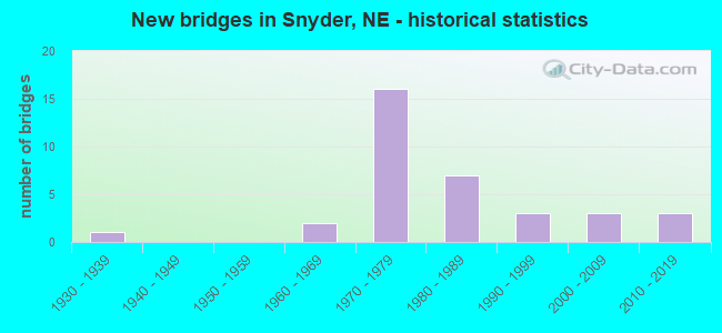
- New bridges - historical statistics
- 11930-1939
- 21960-1969
- 161970-1979
- 71980-1989
- 31990-1999
- 32000-2009
- 32010-2019


- Bridge Condition - Deck
- 3.2%Excellent
- 12.9%Very good
- 51.6%Good
- 9.7%Satisfactory
- 19.4%Fair
- 3.2%Poor

- Bridge Condition - Superstructure
- 3.2%Excellent
- 41.9%Very good
- 48.4%Good
- 3.2%Satisfactory
- 3.2%Fair

- Bridge Condition - Substructure
- 3.2%Excellent
- 32.3%Very good
- 51.6%Good
- 9.7%Satisfactory
- 3.2%Fair

- Bridge Condition - Channel
- 2.9%Excellent
- 37.1%Very good
- 28.6%Good
- 31.4%Satisfactory

- Bridge Condition - Culverts
- 25.0%Excellent
- 25.0%Very good
- 50.0%Good
Find on map >> Show street view
Structure Number: C002002305, Location: 12S OF BEEMER (Lat: 41.748200, Lng: -96.806800), Route carried "on" structure: County highway 7865, Year Built: 1982, Status: Open, Structure Length: 1.83m (6.00ft), Average Daily Traffic: 80 (year 1998), Average Future Daily Traffic: 136 (year 2033), Features Intersected: PEBBLE CREEK
Minimum Vertical Clearance: 30+ m (98+ ft), Kilometerpoint: 0.594, Lanes on structure: 2, Owner: County Highway Agency, Approaching Roadway Width: 7.9m (25.9ft), Material/Design: Steel, Design/Construction: Stringer/Multi-beam, Number Of Spans In Main Unit: 1, Length of Maximum Span: 18.0m (59.1ft), Curb-To-Curb Width: 7.8m (25.6ft), Out-to-Out Width: 8.0m (26.2ft)
Condition: Deck: Fair, Superstructure: Good, Substructure: Good, Channel: Satisfactory, Operating Rating: 71.0 metric tons, Method Used To Determine Operating Rating: Load Factor (LF), Inventory Rating: 42.0 metric tons, Method Used To Determine Inventory Rating: Load Factor (LF), Structural Evaluation: Better than present minimum criteria, Deck Geometry: Equal to present minimum criteria, Waterway Adequacy: Better than present minimum criteria, Approach Roadway Alignment: Equal to present desirable criteria, Designated Inspection Frequency: Every 24 months, Inspection Date: April 2020, Deck Structure Type: Concrete Cast-file-Place, Wearing Surface/Protective System: Wearing Surface: Monolithic Concrete
Find on map >> Show street view
Structure Number: C002002703, Location: 2W 5S OF WEST POINT (Lat: 41.760000, Lng: -96.768300), Route carried "on" structure: County highway 27, Year Built: 2016, Status: Open, Structure Length: 0.91m (2.99ft), Average Daily Traffic: 25 (year 2003), Average Future Daily Traffic: 42 (year 2033), Design Load: HL 93, Features Intersected: COFFEE CREEK, Facility Carried by Structure: TOWNSHIP ROAD
Minimum Vertical Clearance: 30+ m (98+ ft), Kilometerpoint: 0.000, Lanes on structure: 2, Owner: County Highway Agency, Approaching Roadway Width: 8.5m (27.9ft), Material/Design: Steel, Design/Construction: Culvert, Number Of Spans In Main Unit: 3, Length of Maximum Span: 2.4m (7.9ft)
Condition: Channel: Good, Culverts: Very good, Operating Rating: 43.0 metric tons, Method Used To Determine Operating Rating: Load Factor (LF), Inventory Rating: 33.0 metric tons, Method Used To Determine Inventory Rating: Load Factor (LF), Structural Evaluation: Equal to present desirable criteria, Waterway Adequacy: Equal to present desirable criteria, Approach Roadway Alignment: Equal to present desirable criteria, Length Of Structure Improvement: 0.73m (2.40ft), Designated Inspection Frequency: Every 24 months, Inspection Date: October 2021
Find on map >> Show street view
Structure Number: C002002905, Location: 5S 2W OF WEST POINT (Lat: 41.756700, Lng: -96.748300), Route carried "on" structure: County highway 29, Year Built: 1991, Status: Posted for load, Structure Length: 2.13m (6.99ft), Average Daily Traffic: 80 (year 2003), Average Future Daily Traffic: 136 (year 2033), Design Load: HS 20, Features Intersected: COFFEE CREEK, Facility Carried by Structure: TOWNSHIP ROAD
Minimum Vertical Clearance: 30+ m (98+ ft), Kilometerpoint: 0.000, Lanes on structure: 2, Owner: County Highway Agency, Approaching Roadway Width: 7.9m (25.9ft), Skew: 3 degrees, Material/Design: Steel, Design/Construction: Stringer/Multi-beam, Number Of Spans In Main Unit: 1, Length of Maximum Span: 21.0m (68.9ft), Curb-To-Curb Width: 8.5m (27.9ft), Out-to-Out Width: 8.7m (28.5ft)
Condition: Deck: Fair, Superstructure: Good, Substructure: Good, Channel: Satisfactory, Operating Rating: 34.0 metric tons, Method Used To Determine Operating Rating: Load Factor (LF), Inventory Rating: 21.0 metric tons, Method Used To Determine Inventory Rating: Load Factor (LF), Structural Evaluation: Equal to present minimum criteria, Deck Geometry: Better than present minimum criteria, Waterway Adequacy: Equal to present desirable criteria, Approach Roadway Alignment: Equal to present desirable criteria, Bridge Posting: Required (Relationship of Operating Rating to Maximum Legal Load: 0.1 - 9.9% below), Designated Inspection Frequency: Every 24 months, Inspection Date: October 2021, Deck Structure Type: Concrete Cast-file-Place, Wearing Surface/Protective System: Wearing Surface: Monolithic Concrete
Find on map >> Show street view
Structure Number: C002005015, Location: 5E 5S OF ALOYS (Lat: 41.756700, Lng: -96.808300), Route carried "on" structure: County highway 50, Year Built: 1982, Status: Open, Structure Length: 1.83m (6.00ft), Average Daily Traffic: 15 (year 2003), Average Future Daily Traffic: 25 (year 2033), Features Intersected: PEBBLE CREEK, Facility Carried by Structure: TOWNSHIP ROAD
Minimum Vertical Clearance: 30+ m (98+ ft), Kilometerpoint: 0.000, Lanes on structure: 2, Owner: County Highway Agency, Approaching Roadway Width: 6.1m (20.0ft), Material/Design: Steel, Design/Construction: Stringer/Multi-beam, Number Of Spans In Main Unit: 1, Length of Maximum Span: 18.0m (59.1ft), Curb-To-Curb Width: 8.5m (27.9ft), Out-to-Out Width: 8.7m (28.5ft)
Condition: Deck: Fair, Superstructure: Good, Substructure: Good, Channel: Satisfactory, Operating Rating: 44.0 metric tons, Method Used To Determine Operating Rating: Load Factor (LF), Inventory Rating: 26.0 metric tons, Method Used To Determine Inventory Rating: Load Factor (LF), Structural Evaluation: Equal to present minimum criteria, Deck Geometry: Better than present minimum criteria, Waterway Adequacy: Equal to present desirable criteria, Approach Roadway Alignment: Equal to present desirable criteria, Designated Inspection Frequency: Every 24 months, Inspection Date: July 2020, Deck Structure Type: Concrete Cast-file-Place, Wearing Surface/Protective System: Wearing Surface: Monolithic Concrete
Find on map >> Show street view
Structure Number: C002005023, Location: 5S 2.7W WEST POINT (Lat: 41.756700, Lng: -96.761700), Route carried "on" structure: County highway 50, Year Built: 1995, Status: Open, Structure Length: 1.52m (4.99ft), Average Daily Traffic: 25 (year 2003), Average Future Daily Traffic: 42 (year 2033), Features Intersected: COFFEE CREEK, Facility Carried by Structure: TOWNSHIP ROAD
Minimum Vertical Clearance: 30+ m (98+ ft), Kilometerpoint: 0.000, Lanes on structure: 2, Owner: County Highway Agency, Approaching Roadway Width: 7.9m (25.9ft), Skew: 2 degrees, Material/Design: Steel, Design/Construction: Stringer/Multi-beam, Number Of Spans In Main Unit: 1, Length of Maximum Span: 14.9m (48.9ft), Curb-To-Curb Width: 8.5m (27.9ft), Out-to-Out Width: 8.7m (28.5ft)
Condition: Deck: Fair, Superstructure: Very good, Substructure: Very good, Channel: Very good, Operating Rating: 46.0 metric tons, Method Used To Determine Operating Rating: Load Factor (LF), Inventory Rating: 27.0 metric tons, Method Used To Determine Inventory Rating: Load Factor (LF), Structural Evaluation: Equal to present minimum criteria, Deck Geometry: Better than present minimum criteria, Waterway Adequacy: Equal to present desirable criteria, Approach Roadway Alignment: Equal to present desirable criteria, Designated Inspection Frequency: Every 24 months, Inspection Date: April 2020, Deck Structure Type: Concrete Cast-file-Place, Wearing Surface/Protective System: Wearing Surface: Monolithic Concrete
Find on map >> Show street view
Structure Number: C002005025, Location: 5S 2W OF WEST POINT (Lat: 41.756700, Lng: -96.746700), Route carried "on" structure: County highway 50, Year Built: 1984, Status: Open, Structure Length: 1.83m (6.00ft), Average Daily Traffic: 40 (year 2003), Average Future Daily Traffic: 68 (year 2033), Features Intersected: COFFEE CREEK, Facility Carried by Structure: TOWNSHIP ROAD
Minimum Vertical Clearance: 30+ m (98+ ft), Kilometerpoint: 0.000, Lanes on structure: 2, Owner: County Highway Agency, Approaching Roadway Width: 6.7m (22.0ft), Material/Design: Steel, Design/Construction: Stringer/Multi-beam, Number Of Spans In Main Unit: 1, Length of Maximum Span: 17.7m (58.1ft), Curb-To-Curb Width: 8.5m (27.9ft), Out-to-Out Width: 8.5m (27.9ft)
Condition: Deck: Fair, Superstructure: Good, Substructure: Good, Channel: Satisfactory, Operating Rating: 63.0 metric tons, Method Used To Determine Operating Rating: Load Factor (LF), Inventory Rating: 37.0 metric tons, Method Used To Determine Inventory Rating: Load Factor (LF), Structural Evaluation: Better than present minimum criteria, Deck Geometry: Better than present minimum criteria, Waterway Adequacy: Equal to present desirable criteria, Approach Roadway Alignment: Equal to present desirable criteria, Designated Inspection Frequency: Every 24 months, Inspection Date: December 2021, Deck Structure Type: Concrete Cast-file-Place, Wearing Surface/Protective System: Wearing Surface: Monolithic Concrete
Find on map >> Show street view
Structure Number: C00200522, Location: 4W US275 DODGE CL (Lat: 41.742600, Lng: -96.796900), Route carried "on" structure: County highway 7865, Year Built: 1979, Status: Posted for load, Structure Length: 2.96m (9.71ft), Average Daily Traffic: 100 (year 1998), Average Future Daily Traffic: 170 (year 2033), Features Intersected: PEBBLE CREEK
Minimum Vertical Clearance: 30+ m (98+ ft), Kilometerpoint: 0.459, Lanes on structure: 2, Owner: County Highway Agency, Approaching Roadway Width: 8.5m (27.9ft), Material/Design: Steel, Design/Construction: Stringer/Multi-beam, Number Of Spans In Main Unit: 1, Length of Maximum Span: 28.7m (94.2ft), Curb-To-Curb Width: 8.6m (28.2ft), Out-to-Out Width: 9.2m (30.2ft)
Condition: Deck: Fair, Superstructure: Very good, Substructure: Very good, Channel: Satisfactory, Operating Rating: 10.0 metric tons, Method Used To Determine Operating Rating: Load Factor (LF), Inventory Rating: 5.0 metric tons, Method Used To Determine Inventory Rating: Load Factor (LF), Structural Evaluation: High priority of replacement, Deck Geometry: Better than present minimum criteria, Waterway Adequacy: Equal to present desirable criteria, Approach Roadway Alignment: Equal to present desirable criteria, Bridge Posting: Required (Relationship of Operating Rating to Maximum Legal Load: > 39.9% below), Length Of Structure Improvement: 2.96m (9.71ft), Designated Inspection Frequency: Every 24 months, Inspection Date: July 2020, Deck Structure Type: Concrete Cast-file-Place, Wearing Surface/Protective System: Wearing Surface: Monolithic Concrete
Find on map >> Show street view
Structure Number: C002700407, Location: RD. B BET. 5 & 6 (Lat: 41.728300, Lng: -96.823300), Route carried "on" structure: County highway 4, Year Built: 1998, Status: Open, Structure Length: 0.91m (2.99ft), Average Daily Traffic: 25 (year 1997), Average Future Daily Traffic: 42 (year 2033), Design Load: H 20, Features Intersected: STREAM, Facility Carried by Structure: COUNTY HIGHWAY
Minimum Vertical Clearance: 30+ m (98+ ft), Kilometerpoint: 0.000, Lanes on structure: 2, Owner: County Highway Agency, Approaching Roadway Width: 7.9m (25.9ft), Skew: 2 degrees, Material/Design: Steel, Design/Construction: Stringer/Multi-beam, Number Of Spans In Main Unit: 1, Length of Maximum Span: 8.5m (27.9ft), Curb-To-Curb Width: 8.5m (27.9ft), Out-to-Out Width: 8.7m (28.5ft)
Condition: Deck: Very good, Superstructure: Very good, Substructure: Very good, Channel: Very good, Operating Rating: 80.0 metric tons, Method Used To Determine Operating Rating: Load Factor (LF), Inventory Rating: 47.0 metric tons, Method Used To Determine Inventory Rating: Load Factor (LF), Structural Evaluation: Equal to present desirable criteria, Deck Geometry: Better than present minimum criteria, Waterway Adequacy: Equal to present desirable criteria, Approach Roadway Alignment: Equal to present desirable criteria, Designated Inspection Frequency: Every 24 months, Inspection Date: November 2020, Deck Structure Type: Other, Wearing Surface/Protective System: Wearing Surface: Monolithic Concrete
Find on map >> Show street view
Structure Number: C00270041, Location: RD. B BET. 7 & 8, W.BR. (Lat: 41.728300, Lng: -96.788300), Route carried "on" structure: County highway 4, Year Built: 1972, Status: Open, Structure Length: 2.44m (8.01ft), Average Daily Traffic: 35 (year 2003), Average Future Daily Traffic: 59 (year 2033), Design Load: H 20, Features Intersected: PEBBLE CREEK, Facility Carried by Structure: TOWNSHIP ROAD
Minimum Vertical Clearance: 30+ m (98+ ft), Kilometerpoint: 0.000, Lanes on structure: 2, Owner: County Highway Agency, Approaching Roadway Width: 8.5m (27.9ft), Material/Design: Steel, Design/Construction: Stringer/Multi-beam, Number Of Spans In Main Unit: 1, Length of Maximum Span: 23.8m (78.1ft), Curb-To-Curb Width: 8.5m (27.9ft), Out-to-Out Width: 8.7m (28.5ft)
Condition: Deck: Good, Superstructure: Very good, Substructure: Good, Channel: Good, Operating Rating: 50.0 metric tons, Method Used To Determine Operating Rating: Field evaluation and documented engineering judgment, Inventory Rating: 30.0 metric tons, Method Used To Determine Inventory Rating: Field evaluation and documented engineering judgment, Structural Evaluation: Better than present minimum criteria, Deck Geometry: Better than present minimum criteria, Waterway Adequacy: Better than present minimum criteria, Approach Roadway Alignment: Equal to present desirable criteria, Designated Inspection Frequency: Every 24 months, Inspection Date: December 2021, Deck Structure Type: Other, Wearing Surface/Protective System: Wearing Surface: Monolithic Concrete
Find on map >> Show street view
Structure Number: C002700925, Location: RD. 5 BET. E & F, S.BR. (Lat: 41.673300, Lng: -96.828300), Route carried "on" structure: County highway 9, Year Built: 1979, Status: Open, Structure Length: 1.68m (5.51ft), Average Daily Traffic: 50 (year 2003), Average Future Daily Traffic: 85 (year 2033), Design Load: HS 20, Features Intersected: SOUTH PEBBLE CREEK, Facility Carried by Structure: TOWNSHIP ROAD
Minimum Vertical Clearance: 30+ m (98+ ft), Kilometerpoint: 0.000, Lanes on structure: 2, Owner: County Highway Agency, Approaching Roadway Width: 7.9m (25.9ft), Skew: 3 degrees, Material/Design: Steel, Design/Construction: Stringer/Multi-beam, Number Of Spans In Main Unit: 1, Length of Maximum Span: 16.2m (53.1ft), Curb-To-Curb Width: 8.5m (27.9ft), Out-to-Out Width: 8.7m (28.5ft)
Condition: Deck: Good, Superstructure: Good, Substructure: Good, Channel: Good, Operating Rating: 41.0 metric tons, Method Used To Determine Operating Rating: Field evaluation and documented engineering judgment, Inventory Rating: 24.0 metric tons, Method Used To Determine Inventory Rating: Field evaluation and documented engineering judgment, Structural Evaluation: Equal to present minimum criteria, Deck Geometry: Better than present minimum criteria, Waterway Adequacy: Equal to present minimum criteria, Approach Roadway Alignment: Equal to present desirable criteria, Designated Inspection Frequency: Every 24 months, Inspection Date: December 2021, Deck Structure Type: Concrete Cast-file-Place, Wearing Surface/Protective System: Wearing Surface: Monolithic Concrete
Find on map >> Show street view
Structure Number: C00270093, Location: RD. 5 BET. E & F, N.BR. (Lat: 41.676700, Lng: -96.828300), Route carried "on" structure: County highway 9, Year Built: 1979, Status: Open, Structure Length: 1.22m (4.00ft), Average Daily Traffic: 50 (year 2003), Average Future Daily Traffic: 85 (year 2033), Design Load: H 20, Features Intersected: STREAM, Facility Carried by Structure: TOWNSHIP ROAD
Minimum Vertical Clearance: 30+ m (98+ ft), Kilometerpoint: 0.000, Lanes on structure: 2, Owner: County Highway Agency, Approaching Roadway Width: 7.9m (25.9ft), Material/Design: Steel, Design/Construction: Stringer/Multi-beam, Number Of Spans In Main Unit: 1, Length of Maximum Span: 11.6m (38.1ft), Curb-To-Curb Width: 8.5m (27.9ft), Out-to-Out Width: 8.7m (28.5ft)
Condition: Deck: Very good, Superstructure: Very good, Substructure: Very good, Channel: Very good, Operating Rating: 50.0 metric tons, Method Used To Determine Operating Rating: Field evaluation and documented engineering judgment, Inventory Rating: 30.0 metric tons, Method Used To Determine Inventory Rating: Field evaluation and documented engineering judgment, Structural Evaluation: Better than present minimum criteria, Deck Geometry: Better than present minimum criteria, Waterway Adequacy: Equal to present minimum criteria, Approach Roadway Alignment: Equal to present desirable criteria, Designated Inspection Frequency: Every 24 months, Inspection Date: December 2021, Deck Structure Type: Concrete Cast-file-Place, Wearing Surface/Protective System: Wearing Surface: Monolithic Concrete
Find on map >> Show street view
Structure Number: C002700935, Location: RD. 5 BET. HWY.91 & D (Lat: 41.701700, Lng: -96.828300), Route carried "on" structure: County highway 9, Year Built: 2011, Status: Open, Structure Length: 1.28m (4.20ft), Average Daily Traffic: 65 (year 2003), Average Future Daily Traffic: 110 (year 2033), Features Intersected: MIDDLE PEBBLE CREEK, Facility Carried by Structure: TOWNSHIP ROAD
Minimum Vertical Clearance: 30+ m (98+ ft), Kilometerpoint: 0.000, Lanes on structure: 2, Owner: County Highway Agency, Approaching Roadway Width: 8.5m (27.9ft), Material/Design: Steel, Design/Construction: Culvert, Number Of Spans In Main Unit: 6, Length of Maximum Span: 2.1m (6.9ft)
Condition: Channel: Good, Culverts: Excellent, Operating Rating: 42.0 metric tons, Method Used To Determine Operating Rating: Field evaluation and documented engineering judgment, Inventory Rating: 33.0 metric tons, Method Used To Determine Inventory Rating: Field evaluation and documented engineering judgment, Structural Evaluation: Superior to present desirable criteria, Waterway Adequacy: Equal to present desirable criteria, Approach Roadway Alignment: Superior to present desirable criteria, Designated Inspection Frequency: Every 24 months, Inspection Date: January 2022
Find on map >> Show street view
Structure Number: C00270094, Location: RD. 5 BET. A & B (Lat: 41.736700, Lng: -96.828300), Route carried "on" structure: County highway 9, Year Built: 2017, Status: Open, Structure Length: 0.94m (3.08ft), Average Daily Traffic: 40 (year 2003), Average Future Daily Traffic: 68 (year 2033), Design Load: HL 93, Features Intersected: STREAM, Facility Carried by Structure: TOWNSHIP ROAD
Minimum Vertical Clearance: 30+ m (98+ ft), Kilometerpoint: 0.000, Lanes on structure: 2, Owner: County Highway Agency, Approaching Roadway Width: 7.3m (24.0ft), Skew: 3 degrees, Material/Design: Steel, Design/Construction: Stringer/Multi-beam, Number Of Spans In Main Unit: 1, Length of Maximum Span: 9.1m (29.9ft), Curb-To-Curb Width: 8.5m (27.9ft), Out-to-Out Width: 8.7m (28.5ft)
Condition: Deck: Excellent, Superstructure: Excellent, Substructure: Excellent, Channel: Good, Operating Rating: 44.0 metric tons, Method Used To Determine Operating Rating: Field evaluation and documented engineering judgment, Inventory Rating: 34.0 metric tons, Method Used To Determine Inventory Rating: Field evaluation and documented engineering judgment, Structural Evaluation: Superior to present desirable criteria, Deck Geometry: Better than present minimum criteria, Waterway Adequacy: Better than present minimum criteria, Approach Roadway Alignment: Better than present minimum criteria, Designated Inspection Frequency: Every 24 months, Inspection Date: December 2021, Deck Structure Type: Concrete Cast-file-Place, Wearing Surface/Protective System: Wearing Surface: Monolithic Concrete
Find on map >> Show street view
Structure Number: C00270101, Location: RD. E BET. 5 & 6 (Lat: 41.685000, Lng: -96.813300), Route carried "on" structure: County highway 10, Year Built: 1984, Status: Open, Structure Length: 2.13m (6.99ft), Average Daily Traffic: 35 (year 2003), Average Future Daily Traffic: 59 (year 2033), Features Intersected: SOUTH PEBBLE CREEK, Facility Carried by Structure: TOWNSHIP ROAD
Minimum Vertical Clearance: 30+ m (98+ ft), Kilometerpoint: 0.000, Lanes on structure: 2, Owner: County Highway Agency, Approaching Roadway Width: 7.9m (25.9ft), Material/Design: Steel, Design/Construction: Stringer/Multi-beam, Number Of Spans In Main Unit: 1, Length of Maximum Span: 20.7m (67.9ft), Curb-To-Curb Width: 8.5m (27.9ft), Out-to-Out Width: 8.7m (28.5ft)
Condition: Deck: Good, Superstructure: Very good, Substructure: Good, Channel: Very good, Operating Rating: 42.0 metric tons, Method Used To Determine Operating Rating: Field evaluation and documented engineering judgment, Inventory Rating: 24.0 metric tons, Method Used To Determine Inventory Rating: Field evaluation and documented engineering judgment, Structural Evaluation: Equal to present minimum criteria, Deck Geometry: Better than present minimum criteria, Waterway Adequacy: Equal to present desirable criteria, Approach Roadway Alignment: Equal to present desirable criteria, Length Of Structure Improvement: 2.13m (6.99ft), Designated Inspection Frequency: Every 24 months, Inspection Date: December 2021, Deck Structure Type: Concrete Cast-file-Place, Wearing Surface/Protective System: Wearing Surface: Monolithic Concrete
Find on map >> Show street view
Structure Number: C002701015, Location: RD. E BET 9 & 10 (Lat: 41.684500, Lng: -96.745900), Route carried "on" structure: County highway 10, Year Built: 1968, Status: Open, Structure Length: 2.44m (8.01ft), Average Daily Traffic: 50 (year 2003), Average Future Daily Traffic: 85 (year 2033), Design Load: H 15, Features Intersected: PEBBLE CREEK, Facility Carried by Structure: ROAD E
Minimum Vertical Clearance: 30+ m (98+ ft), Kilometerpoint: 0.000, Lanes on structure: 2, Owner: County Highway Agency, Approaching Roadway Width: 7.9m (25.9ft), Material/Design: Steel, Design/Construction: Stringer/Multi-beam, Number Of Spans In Main Unit: 1, Length of Maximum Span: 23.8m (78.1ft), Curb-To-Curb Width: 7.2m (23.6ft), Out-to-Out Width: 7.3m (24.0ft)
Condition: Deck: Good, Superstructure: Good, Substructure: Good, Channel: Satisfactory, Operating Rating: 49.0 metric tons, Method Used To Determine Operating Rating: Load Factor (LF), Inventory Rating: 29.0 metric tons, Method Used To Determine Inventory Rating: Load Factor (LF), Structural Evaluation: Better than present minimum criteria, Deck Geometry: Somewhat better than minimum adequacy, Waterway Adequacy: Equal to present desirable criteria, Approach Roadway Alignment: Equal to present desirable criteria, Designated Inspection Frequency: Every 24 months, Inspection Date: Febuary 2022, Deck Structure Type: Concrete Cast-file-Place, Wearing Surface/Protective System: Wearing Surface: Monolithic Concrete
Find on map >> Show street view
Structure Number: C00270113, Location: RD. 6 BET. D & E, S.BR. (Lat: 41.691700, Lng: -96.810000), Route carried "on" structure: County highway 11, Year Built: 1971, Status: Posted for load, Structure Length: 1.52m (4.99ft), Average Daily Traffic: 55 (year 2003), Average Future Daily Traffic: 93 (year 2033), Features Intersected: SOUTH PEBBLE CREEK, Facility Carried by Structure: TOWNSHIP ROAD
Minimum Vertical Clearance: 30+ m (98+ ft), Kilometerpoint: 0.000, Lanes on structure: 2, Owner: County Highway Agency, Approaching Roadway Width: 8.5m (27.9ft), Material/Design: Steel, Design/Construction: Stringer/Multi-beam, Number Of Spans In Main Unit: 1, Length of Maximum Span: 14.6m (47.9ft), Curb-To-Curb Width: 8.5m (27.9ft), Out-to-Out Width: 8.7m (28.5ft)
Condition: Deck: Good, Superstructure: Very good, Substructure: Very good, Channel: Good, Operating Rating: 33.0 metric tons, Method Used To Determine Operating Rating: Field evaluation and documented engineering judgment, Inventory Rating: 20.0 metric tons, Method Used To Determine Inventory Rating: Field evaluation and documented engineering judgment, Structural Evaluation: Somewhat better than minimum adequacy, Deck Geometry: Better than present minimum criteria, Waterway Adequacy: Better than present minimum criteria, Approach Roadway Alignment: Equal to present desirable criteria, Bridge Posting: Required (Relationship of Operating Rating to Maximum Legal Load: 10.0 - 19.9% below), Designated Inspection Frequency: Every 24 months, Inspection Date: December 2021, Deck Structure Type: Concrete Cast-file-Place, Wearing Surface/Protective System: Wearing Surface: Monolithic Concrete
Find on map >> Show street view
Structure Number: C002701135, Location: RD. 6 BET. D & E, N.BR. (Lat: 41.696700, Lng: -96.810000), Route carried "on" structure: County highway 11, Year Built: 1971, Status: Open, Structure Length: 1.83m (6.00ft), Average Daily Traffic: 55 (year 2003), Average Future Daily Traffic: 93 (year 2033), Features Intersected: MIDDLE PEBBLE CREEK, Facility Carried by Structure: TOWNSHIP ROAD
Minimum Vertical Clearance: 30+ m (98+ ft), Kilometerpoint: 0.000, Lanes on structure: 2, Owner: County Highway Agency, Approaching Roadway Width: 8.5m (27.9ft), Material/Design: Steel, Design/Construction: Stringer/Multi-beam, Number Of Spans In Main Unit: 1, Length of Maximum Span: 17.7m (58.1ft), Curb-To-Curb Width: 8.5m (27.9ft), Out-to-Out Width: 8.7m (28.5ft)
Condition: Deck: Good, Superstructure: Good, Substructure: Good, Channel: Good, Operating Rating: 38.0 metric tons, Method Used To Determine Operating Rating: Field evaluation and documented engineering judgment, Inventory Rating: 23.0 metric tons, Method Used To Determine Inventory Rating: Field evaluation and documented engineering judgment, Structural Evaluation: Equal to present minimum criteria, Deck Geometry: Better than present minimum criteria, Waterway Adequacy: Equal to present desirable criteria, Approach Roadway Alignment: Equal to present desirable criteria, Designated Inspection Frequency: Every 24 months, Inspection Date: December 2021, Deck Structure Type: Concrete Cast-file-Place, Wearing Surface/Protective System: Wearing Surface: Monolithic Concrete
Find on map >> Show street view
Structure Number: C00270114, Location: RD. 6 BET. B & C (Lat: 41.715000, Lng: -96.808300), Route carried "on" structure: County highway 11, Year Built: 1980, Status: Open, Structure Length: 1.04m (3.41ft), Average Daily Traffic: 80 (year 2003), Average Future Daily Traffic: 136 (year 2033), Design Load: H 20, Features Intersected: STREAM, Facility Carried by Structure: TOWNSHIP ROAD
Minimum Vertical Clearance: 30+ m (98+ ft), Kilometerpoint: 0.000, Lanes on structure: 2, Owner: County Highway Agency, Approaching Roadway Width: 8.5m (27.9ft), Skew: 5 degrees, Material/Design: Steel, Design/Construction: Stringer/Multi-beam, Number Of Spans In Main Unit: 1, Length of Maximum Span: 9.8m (32.2ft), Curb-To-Curb Width: 8.5m (27.9ft), Out-to-Out Width: 8.7m (28.5ft)
Condition: Deck: Satisfactory, Superstructure: Satisfactory, Substructure: Satisfactory, Channel: Satisfactory, Operating Rating: 46.0 metric tons, Method Used To Determine Operating Rating: Field evaluation and documented engineering judgment, Inventory Rating: 27.0 metric tons, Method Used To Determine Inventory Rating: Field evaluation and documented engineering judgment, Structural Evaluation: Equal to present minimum criteria, Deck Geometry: Better than present minimum criteria, Waterway Adequacy: Equal to present desirable criteria, Approach Roadway Alignment: Equal to present desirable criteria, Designated Inspection Frequency: Every 24 months, Inspection Date: December 2021, Deck Structure Type: Concrete Cast-file-Place, Wearing Surface/Protective System: Wearing Surface: Monolithic Concrete
Find on map >> Show street view
Structure Number: C002701205, Location: RD. F BET. 4 & 5 (Lat: 41.669900, Lng: -96.834100), Route carried "on" structure: County highway 3490, Year Built: 2007, Status: Open, Structure Length: 2.26m (7.41ft), Average Daily Traffic: 60 (year 2011), Average Future Daily Traffic: 60 (year 2033), Design Load: H 20, Features Intersected: SOUTH PEBBLE CREEK, Facility Carried by Structure: COUNTY ROADF
Minimum Vertical Clearance: 30+ m (98+ ft), Kilometerpoint: 1.081, Lanes on structure: 2, Owner: County Highway Agency, Approaching Roadway Width: 8.5m (27.9ft), Skew: 3 degrees, Material/Design: Steel, Design/Construction: Stringer/Multi-beam, Number Of Spans In Main Unit: 1, Length of Maximum Span: 22.3m (73.2ft), Curb-To-Curb Width: 8.5m (27.9ft), Out-to-Out Width: 8.7m (28.5ft)
Condition: Deck: Good, Superstructure: Very good, Substructure: Very good, Channel: Excellent, Operating Rating: 55.0 metric tons, Method Used To Determine Operating Rating: Field evaluation and documented engineering judgment, Inventory Rating: 33.0 metric tons, Method Used To Determine Inventory Rating: Field evaluation and documented engineering judgment, Structural Evaluation: Equal to present desirable criteria, Deck Geometry: Better than present minimum criteria, Waterway Adequacy: Superior to present desirable criteria, Approach Roadway Alignment: Equal to present desirable criteria, Length Of Structure Improvement: 1.65m (5.41ft), Designated Inspection Frequency: Every 24 months, Inspection Date: December 2021, Deck Structure Type: Concrete Cast-file-Place, Wearing Surface/Protective System: Wearing Surface: Monolithic Concrete
Find on map >> Show street view
Structure Number: C00270142, Location: RD. G BET. 8 & 9 (Lat: 41.655000, Lng: -96.758300), Route carried "on" structure: County highway 14, Year Built: 1979, Status: Open, Structure Length: 1.22m (4.00ft), Average Daily Traffic: 35 (year 2003), Average Future Daily Traffic: 59 (year 2033), Design Load: H 20, Features Intersected: STREAM, Facility Carried by Structure: TOWNSHIP ROAD
Minimum Vertical Clearance: 30+ m (98+ ft), Kilometerpoint: 0.000, Lanes on structure: 2, Owner: County Highway Agency, Approaching Roadway Width: 7.9m (25.9ft), Skew: 4 degrees, Material/Design: Steel, Design/Construction: Stringer/Multi-beam, Number Of Spans In Main Unit: 1, Length of Maximum Span: 11.3m (37.1ft), Curb-To-Curb Width: 8.5m (27.9ft), Out-to-Out Width: 8.7m (28.5ft)
Condition: Deck: Good, Superstructure: Good, Substructure: Good, Channel: Very good, Operating Rating: 47.0 metric tons, Method Used To Determine Operating Rating: Load Factor (LF), Inventory Rating: 28.0 metric tons, Method Used To Determine Inventory Rating: Load Factor (LF), Structural Evaluation: Better than present minimum criteria, Deck Geometry: Better than present minimum criteria, Waterway Adequacy: Equal to present desirable criteria, Approach Roadway Alignment: Equal to present desirable criteria, Designated Inspection Frequency: Every 24 months, Inspection Date: November 2020, Deck Structure Type: Concrete Cast-file-Place, Wearing Surface/Protective System: Wearing Surface: Monolithic Concrete
Find on map >> Show street view
Structure Number: C00270161, Location: RD. H BET. 7 & 8 (Lat: 41.641700, Lng: -96.783300), Route carried "on" structure: County highway 16, Year Built: 1986, Status: Open, Structure Length: 0.91m (2.99ft), Average Daily Traffic: 60 (year 2003), Average Future Daily Traffic: 102 (year 2033), Design Load: H 20, Features Intersected: SILVER CREEK, Facility Carried by Structure: TOWNSHIP ROAD
Minimum Vertical Clearance: 30+ m (98+ ft), Kilometerpoint: 0.000, Lanes on structure: 2, Owner: County Highway Agency, Approaching Roadway Width: 7.9m (25.9ft), Material/Design: Steel, Design/Construction: Stringer/Multi-beam, Number Of Spans In Main Unit: 1, Length of Maximum Span: 8.5m (27.9ft), Curb-To-Curb Width: 8.5m (27.9ft), Out-to-Out Width: 8.7m (28.5ft)
Condition: Deck: Very good, Superstructure: Very good, Substructure: Very good, Channel: Very good, Operating Rating: 73.0 metric tons, Method Used To Determine Operating Rating: Load Factor (LF), Inventory Rating: 44.0 metric tons, Method Used To Determine Inventory Rating: Load Factor (LF), Structural Evaluation: Equal to present desirable criteria, Deck Geometry: Better than present minimum criteria, Waterway Adequacy: Equal to present desirable criteria, Approach Roadway Alignment: Equal to present desirable criteria, Designated Inspection Frequency: Every 24 months, Inspection Date: November 2020, Deck Structure Type: Concrete Cast-file-Place, Wearing Surface/Protective System: Wearing Surface: Monolithic Concrete
Find on map >> Show street view
Structure Number: C00270174, Location: RD. 9 BET. G & H (Lat: 41.653300, Lng: -96.751700), Route carried "on" structure: County highway 17, Year Built: 1935, Status: Open, Structure Length: 0.98m (3.22ft), Average Daily Traffic: 25 (year 2003), Average Future Daily Traffic: 42 (year 2033), Features Intersected: STREAM, Facility Carried by Structure: TOWNSHIP ROAD
Minimum Vertical Clearance: 30+ m (98+ ft), Kilometerpoint: 0.000, Lanes on structure: 2, Owner: County Highway Agency, Approaching Roadway Width: 7.3m (24.0ft), Material/Design: Steel, Design/Construction: Stringer/Multi-beam, Number Of Spans In Main Unit: 1, Length of Maximum Span: 9.4m (30.8ft), Curb-To-Curb Width: 5.4m (17.7ft), Out-to-Out Width: 5.5m (18.0ft)
Condition: Deck: Poor, Superstructure: Fair, Substructure: Fair, Channel: Good, Operating Rating: 44.0 metric tons, Method Used To Determine Operating Rating: Load Factor (LF), Inventory Rating: 26.0 metric tons, Method Used To Determine Inventory Rating: Load Factor (LF), Structural Evaluation: Somewhat better than minimum adequacy, Deck Geometry: High priority of corrective action, Waterway Adequacy: Better than present minimum criteria, Approach Roadway Alignment: Better than present minimum criteria, Length Of Structure Improvement: 0.98m (3.22ft), Designated Inspection Frequency: Every 24 months, Inspection Date: November 2020, Deck Structure Type: Concrete Cast-file-Place, Wearing Surface/Protective System: Wearing Surface: Monolithic Concrete
Find on map >> Show street view
Structure Number: C00270195, Location: RD. 10 BET. E & F, N.BR. (Lat: 41.677300, Lng: -96.732600), Route carried "on" structure: County highway 7855, Year Built: 1970, Status: Posted for load, Structure Length: 2.44m (8.01ft), Average Daily Traffic: 70 (year 1998), Average Future Daily Traffic: 119 (year 2033), Features Intersected: PEBBLE CREEK
Minimum Vertical Clearance: 30+ m (98+ ft), Kilometerpoint: 2.433, Lanes on structure: 2, Owner: County Highway Agency, Approaching Roadway Width: 7.9m (25.9ft), Skew: 3 degrees, Material/Design: Steel, Design/Construction: Stringer/Multi-beam, Number Of Spans In Main Unit: 1, Length of Maximum Span: 23.8m (78.1ft), Curb-To-Curb Width: 8.5m (27.9ft), Out-to-Out Width: 8.7m (28.5ft)
Condition: Deck: Good, Superstructure: Good, Substructure: Satisfactory, Channel: Very good, Operating Rating: 31.0 metric tons, Method Used To Determine Operating Rating: Load Factor (LF), Inventory Rating: 18.0 metric tons, Method Used To Determine Inventory Rating: Load Factor (LF), Structural Evaluation: Somewhat better than minimum adequacy, Deck Geometry: Better than present minimum criteria, Waterway Adequacy: Equal to present desirable criteria, Approach Roadway Alignment: Equal to present desirable criteria, Bridge Posting: Required (Relationship of Operating Rating to Maximum Legal Load: 10.0 - 19.9% below), Designated Inspection Frequency: Every 24 months, Inspection Date: November 2021, Deck Structure Type: Concrete Cast-file-Place, Wearing Surface/Protective System: Wearing Surface: Monolithic Concrete
Find on map >> Show street view
Structure Number: C002701955, Location: RD. 10 BET. C & D (Lat: 41.711700, Lng: -96.731700), Route carried "on" structure: County highway 19, Year Built: 1972, Status: Posted for load, Structure Length: 1.52m (4.99ft), Average Daily Traffic: 85 (year 2003), Average Future Daily Traffic: 144 (year 2033), Design Load: H 15, Features Intersected: STREAM, Facility Carried by Structure: TOWNSHIP ROAD
Minimum Vertical Clearance: 30+ m (98+ ft), Kilometerpoint: 0.000, Lanes on structure: 2, Owner: County Highway Agency, Approaching Roadway Width: 8.5m (27.9ft), Material/Design: Steel, Design/Construction: Stringer/Multi-beam, Number Of Spans In Main Unit: 1, Length of Maximum Span: 14.6m (47.9ft), Curb-To-Curb Width: 8.5m (27.9ft), Out-to-Out Width: 8.7m (28.5ft)
Condition: Deck: Good, Superstructure: Good, Substructure: Good, Channel: Good, Operating Rating: 34.0 metric tons, Method Used To Determine Operating Rating: Load Factor (LF), Inventory Rating: 20.0 metric tons, Method Used To Determine Inventory Rating: Load Factor (LF), Structural Evaluation: Somewhat better than minimum adequacy, Deck Geometry: Better than present minimum criteria, Waterway Adequacy: Equal to present minimum criteria, Approach Roadway Alignment: Equal to present desirable criteria, Bridge Posting: Required (Relationship of Operating Rating to Maximum Legal Load: 0.1 - 9.9% below), Designated Inspection Frequency: Every 24 months, Inspection Date: November 2021, Deck Structure Type: Concrete Cast-file-Place, Wearing Surface/Protective System: Wearing Surface: Monolithic Concrete
Find on map >> Show street view
Structure Number: C002710625, Location: RD. C BET. 9 & 10 (Lat: 41.713300, Lng: -96.733300), Route carried "on" structure: County highway 106, Year Built: 1972, Status: Open, Structure Length: 1.22m (4.00ft), Average Daily Traffic: 35 (year 2003), Average Future Daily Traffic: 59 (year 2033), Design Load: H 20, Features Intersected: STREAM, Facility Carried by Structure: TOWNSHIP ROAD
Minimum Vertical Clearance: 30+ m (98+ ft), Kilometerpoint: 0.000, Lanes on structure: 2, Owner: County Highway Agency, Approaching Roadway Width: 7.3m (24.0ft), Material/Design: Steel, Design/Construction: Stringer/Multi-beam, Number Of Spans In Main Unit: 1, Length of Maximum Span: 11.6m (38.1ft), Curb-To-Curb Width: 8.5m (27.9ft), Out-to-Out Width: 8.7m (28.5ft)
Condition: Deck: Good, Superstructure: Very good, Substructure: Good, Channel: Very good, Operating Rating: 42.0 metric tons, Method Used To Determine Operating Rating: Field evaluation and documented engineering judgment, Inventory Rating: 25.0 metric tons, Method Used To Determine Inventory Rating: Field evaluation and documented engineering judgment, Structural Evaluation: Equal to present minimum criteria, Deck Geometry: Better than present minimum criteria, Waterway Adequacy: Equal to present desirable criteria, Approach Roadway Alignment: Better than present minimum criteria, Designated Inspection Frequency: Every 24 months, Inspection Date: December 2021, Deck Structure Type: Concrete Cast-file-Place, Wearing Surface/Protective System: Wearing Surface: Monolithic Concrete
Find on map >> Show street view
Structure Number: C00271134, Location: RD. 7 BET. B & C, S. BR. (Lat: 41.715700, Lng: -96.790000), Route carried "on" structure: County highway 7865, Year Built: 1972, Status: Open, Structure Length: 1.22m (4.00ft), Average Daily Traffic: 210 (year 1998), Average Future Daily Traffic: 357 (year 2033), Features Intersected: STREAM
Minimum Vertical Clearance: 30+ m (98+ ft), Kilometerpoint: 0.103, Lanes on structure: 2, Owner: County Highway Agency, Approaching Roadway Width: 8.5m (27.9ft), Material/Design: Steel, Design/Construction: Stringer/Multi-beam, Number Of Spans In Main Unit: 1, Length of Maximum Span: 11.6m (38.1ft), Curb-To-Curb Width: 8.5m (27.9ft), Out-to-Out Width: 8.7m (28.5ft)
Condition: Deck: Good, Superstructure: Good, Substructure: Good, Channel: Very good, Operating Rating: 43.0 metric tons, Method Used To Determine Operating Rating: Field evaluation and documented engineering judgment, Inventory Rating: 25.0 metric tons, Method Used To Determine Inventory Rating: Field evaluation and documented engineering judgment, Structural Evaluation: Equal to present minimum criteria, Deck Geometry: Equal to present minimum criteria, Waterway Adequacy: Equal to present desirable criteria, Approach Roadway Alignment: Equal to present desirable criteria, Designated Inspection Frequency: Every 24 months, Inspection Date: December 2021, Deck Structure Type: Concrete Cast-file-Place, Wearing Surface/Protective System: Wearing Surface: Monolithic Concrete
Find on map >> Show street view
Structure Number: C002711345, Location: RD. 7 BET. B & C, N.BR. (Lat: 41.726400, Lng: -96.790000), Route carried "on" structure: County highway 7865, Year Built: 1972, Status: Open, Structure Length: 0.91m (2.99ft), Average Daily Traffic: 210 (year 1998), Average Future Daily Traffic: 357 (year 2033), Features Intersected: STREAM
Minimum Vertical Clearance: 30+ m (98+ ft), Kilometerpoint: 0.222, Lanes on structure: 2, Owner: County Highway Agency, Approaching Roadway Width: 8.5m (27.9ft), Material/Design: Steel, Design/Construction: Stringer/Multi-beam, Number Of Spans In Main Unit: 1, Length of Maximum Span: 8.5m (27.9ft), Curb-To-Curb Width: 8.5m (27.9ft), Out-to-Out Width: 8.7m (28.5ft)
Condition: Deck: Satisfactory, Superstructure: Good, Substructure: Good, Channel: Satisfactory, Operating Rating: 39.0 metric tons, Method Used To Determine Operating Rating: Field evaluation and documented engineering judgment, Inventory Rating: 23.0 metric tons, Method Used To Determine Inventory Rating: Field evaluation and documented engineering judgment, Structural Evaluation: Equal to present minimum criteria, Deck Geometry: Equal to present minimum criteria, Waterway Adequacy: Better than present minimum criteria, Approach Roadway Alignment: Equal to present desirable criteria, Designated Inspection Frequency: Every 24 months, Inspection Date: December 2021, Deck Structure Type: Concrete Cast-file-Place, Wearing Surface/Protective System: Wearing Surface: Monolithic Concrete
Find on map >> Show street view
Structure Number: C00271135, Location: RD. 7 BET. A & B (Lat: 41.732800, Lng: -96.790100), Route carried "on" structure: County highway 7865, Year Built: 1972, Status: Posted for load, Structure Length: 2.44m (8.01ft), Average Daily Traffic: 210 (year 1998), Average Future Daily Traffic: 357 (year 2033), Features Intersected: PEBBLE CREEK
Minimum Vertical Clearance: 30+ m (98+ ft), Kilometerpoint: 0.295, Lanes on structure: 2, Owner: County Highway Agency, Approaching Roadway Width: 8.5m (27.9ft), Skew: 2 degrees, Material/Design: Steel, Design/Construction: Stringer/Multi-beam, Number Of Spans In Main Unit: 1, Length of Maximum Span: 23.8m (78.1ft), Curb-To-Curb Width: 8.5m (27.9ft), Out-to-Out Width: 8.7m (28.5ft)
Condition: Deck: Good, Superstructure: Good, Substructure: Satisfactory, Channel: Satisfactory, Operating Rating: 30.0 metric tons, Method Used To Determine Operating Rating: Field evaluation and documented engineering judgment, Inventory Rating: 18.0 metric tons, Method Used To Determine Inventory Rating: Field evaluation and documented engineering judgment, Structural Evaluation: Somewhat better than minimum adequacy, Deck Geometry: Equal to present minimum criteria, Waterway Adequacy: Better than present minimum criteria, Approach Roadway Alignment: Equal to present desirable criteria, Bridge Posting: Required (Relationship of Operating Rating to Maximum Legal Load: 10.0 - 19.9% below), Designated Inspection Frequency: Every 24 months, Inspection Date: December 2021, Deck Structure Type: Concrete Cast-file-Place, Wearing Surface/Protective System: Wearing Surface: Monolithic Concrete
Find on map >> Show street view
Structure Number: C00272153, Location: RD. 8 BET. F & G (Lat: 41.656700, Lng: -96.770000), Route carried "on" structure: County highway 215, Year Built: 1981, Status: Open, Structure Length: 1.07m (3.51ft), Average Daily Traffic: 50 (year 2003), Average Future Daily Traffic: 85 (year 2033), Design Load: H 20, Features Intersected: STREAM, Facility Carried by Structure: TOWNSHIP ROAD
Minimum Vertical Clearance: 30+ m (98+ ft), Kilometerpoint: 0.000, Lanes on structure: 2, Owner: County Highway Agency, Approaching Roadway Width: 7.9m (25.9ft), Material/Design: Steel, Design/Construction: Stringer/Multi-beam, Number Of Spans In Main Unit: 1, Length of Maximum Span: 10.1m (33.1ft), Curb-To-Curb Width: 8.5m (27.9ft), Out-to-Out Width: 8.7m (28.5ft)
Condition: Deck: Good, Superstructure: Good, Substructure: Good, Channel: Very good, Operating Rating: 40.0 metric tons, Method Used To Determine Operating Rating: Load Factor (LF), Inventory Rating: 24.0 metric tons, Method Used To Determine Inventory Rating: Load Factor (LF), Structural Evaluation: Equal to present minimum criteria, Deck Geometry: Better than present minimum criteria, Waterway Adequacy: Equal to present desirable criteria, Approach Roadway Alignment: Equal to present desirable criteria, Designated Inspection Frequency: Every 24 months, Inspection Date: Febuary 2022, Deck Structure Type: Concrete Cast-file-Place, Wearing Surface/Protective System: Wearing Surface: Monolithic Concrete
Find on map >> Show street view
Structure Number: C002721535, Location: RD. 8 BET. HWY.91 & D (Lat: 41.700000, Lng: -96.771700), Route carried "on" structure: County highway 215, Year Built: 1975, Status: Open, Structure Length: 2.44m (8.01ft), Average Daily Traffic: 70 (year 2003), Average Future Daily Traffic: 119 (year 2033), Design Load: H 20, Features Intersected: MIDDLE PEBBLE, Facility Carried by Structure: TOWNSHIP ROAD
Minimum Vertical Clearance: 30+ m (98+ ft), Kilometerpoint: 0.000, Lanes on structure: 2, Owner: County Highway Agency, Approaching Roadway Width: 8.5m (27.9ft), Material/Design: Steel, Design/Construction: Stringer/Multi-beam, Number Of Spans In Main Unit: 1, Length of Maximum Span: 23.8m (78.1ft), Curb-To-Curb Width: 8.5m (27.9ft), Out-to-Out Width: 8.7m (28.5ft)
Condition: Deck: Very good, Superstructure: Very good, Substructure: Very good, Channel: Satisfactory, Operating Rating: 48.0 metric tons, Method Used To Determine Operating Rating: Field evaluation and documented engineering judgment, Inventory Rating: 29.0 metric tons, Method Used To Determine Inventory Rating: Field evaluation and documented engineering judgment, Structural Evaluation: Better than present minimum criteria, Deck Geometry: Better than present minimum criteria, Waterway Adequacy: Equal to present desirable criteria, Approach Roadway Alignment: Equal to present desirable criteria, Designated Inspection Frequency: Every 24 months, Inspection Date: December 2021, Deck Structure Type: Concrete Cast-file-Place, Wearing Surface/Protective System: Wearing Surface: Monolithic Concrete
Find on map >> Show street view
Structure Number: C00272154, Location: RD. 8 BET. HWY.91 & C (Lat: 41.711700, Lng: -96.771700), Route carried "on" structure: County highway 215, Year Built: 1975, Status: Open, Structure Length: 2.44m (8.01ft), Average Daily Traffic: 85 (year 2003), Average Future Daily Traffic: 144 (year 2033), Design Load: HS 20, Features Intersected: PEBBLE CREEK, Facility Carried by Structure: TOWNSHIP ROAD
Minimum Vertical Clearance: 30+ m (98+ ft), Kilometerpoint: 0.000, Lanes on structure: 2, Owner: County Highway Agency, Approaching Roadway Width: 8.5m (27.9ft), Material/Design: Steel, Design/Construction: Stringer/Multi-beam, Number Of Spans In Main Unit: 1, Length of Maximum Span: 23.8m (78.1ft), Curb-To-Curb Width: 8.5m (27.9ft), Out-to-Out Width: 8.7m (28.5ft)
Condition: Deck: Good, Superstructure: Good, Substructure: Good, Channel: Satisfactory, Operating Rating: 48.0 metric tons, Method Used To Determine Operating Rating: Field evaluation and documented engineering judgment, Inventory Rating: 29.0 metric tons, Method Used To Determine Inventory Rating: Field evaluation and documented engineering judgment, Structural Evaluation: Better than present minimum criteria, Deck Geometry: Better than present minimum criteria, Waterway Adequacy: Equal to present desirable criteria, Approach Roadway Alignment: Equal to present desirable criteria, Designated Inspection Frequency: Every 24 months, Inspection Date: December 2021, Deck Structure Type: Concrete Cast-file-Place, Wearing Surface/Protective System: Wearing Surface: Monolithic Concrete
Find on map >> Show street view
Structure Number: S079 00206, Location: 7S AGNEW (Lat: 40.915300, Lng: -96.795600), Route carried "on" structure: State highway 79, Year Built: 2007, Status: Open, Structure Length: 0.98m (3.22ft), Average Daily Traffic: 3,460 (year 2018), Truck Traffic: 8%, Average Future Daily Traffic: 5,709 (year 2038), Design Load: HS 20, Features Intersected: STREAM
Minimum Vertical Clearance: 30+ m (98+ ft), Kilometerpoint: 0.332, Lanes on structure: 2, Owner: State Highway Agency, Approaching Roadway Width: 7.3m (24.0ft), Skew: 1 degrees, Material/Design: Concrete, Design/Construction: Culvert, Number Of Spans In Main Unit: 3, Length of Maximum Span: 3.0m (9.8ft)
Condition: Channel: Good, Culverts: Good, Operating Rating: 43.0 metric tons, Method Used To Determine Operating Rating: Field evaluation and documented engineering judgment, Inventory Rating: 33.0 metric tons, Method Used To Determine Inventory Rating: Field evaluation and documented engineering judgment, Structural Evaluation: Better than present minimum criteria, Waterway Adequacy: Equal to present minimum criteria, Approach Roadway Alignment: Somewhat better than minimum adequacy, Designated Inspection Frequency: Every 48 months, Inspection Date: Febuary 2021
Find on map >> Show street view
Structure Number: S079 05622, Location: 4S SNYDER (Lat: 41.647800, Lng: -96.790000), Route carried "on" structure: State highway 79, Year Built: 1971, Year Reconstructed: 1996, Status: Open, Structure Length: 0.85m (2.79ft), Average Daily Traffic: 1,045 (year 2018), Truck Traffic: 22%, Average Future Daily Traffic: 1,306 (year 2038), Features Intersected: STREAM
Minimum Vertical Clearance: 30+ m (98+ ft), Kilometerpoint: 9.048, Lanes on structure: 2, Owner: State Highway Agency, Approaching Roadway Width: 7.3m (24.0ft), Skew: 3 degrees, Material/Design: Concrete, Design/Construction: Culvert, Number Of Spans In Main Unit: 2, Length of Maximum Span: 3.7m (12.1ft)
Condition: Channel: Very good, Culverts: Good, Operating Rating: 33.0 metric tons, Method Used To Determine Operating Rating: Field evaluation and documented engineering judgment, Inventory Rating: 22.0 metric tons, Method Used To Determine Inventory Rating: Field evaluation and documented engineering judgment, Structural Evaluation: Somewhat better than minimum adequacy, Waterway Adequacy: Equal to present desirable criteria, Approach Roadway Alignment: Equal to present desirable criteria, Designated Inspection Frequency: Every 24 months, Inspection Date: January 2022
Find on map >> Show street view
Structure Number: S079 05979, Location: 1S SNYDER (Lat: 41.699300, Lng: -96.789900), Route carried "on" structure: State highway 79, Year Built: 1965, Year Reconstructed: 1996, Status: Open, Structure Length: 4.66m (15.29ft), Average Daily Traffic: 1,045 (year 2018), Truck Traffic: 22%, Average Future Daily Traffic: 1,306 (year 2038), Features Intersected: STREAM
Minimum Vertical Clearance: 30+ m (98+ ft), Kilometerpoint: 9.622, Lanes on structure: 2, Owner: State Highway Agency, Approaching Roadway Width: 7.3m (24.0ft), Material/Design: Steel, Design/Construction: Stringer/Multi-beam, Number Of Spans In Main Unit: 1, Length of Maximum Span: 45.7m (149.9ft), Curb-To-Curb Width: 10.7m (35.1ft), Out-to-Out Width: 11.4m (37.4ft)
Condition: Deck: Good, Superstructure: Very good, Substructure: Very good, Channel: Very good, Operating Rating: 83.0 metric tons, Method Used To Determine Operating Rating: Load Factor (LF), Inventory Rating: 50.0 metric tons, Method Used To Determine Inventory Rating: Load Factor (LF), Structural Evaluation: Equal to present desirable criteria, Deck Geometry: Equal to present minimum criteria, Waterway Adequacy: Equal to present desirable criteria, Approach Roadway Alignment: Equal to present desirable criteria, Designated Inspection Frequency: Every 24 months, Inspection Date: January 2022, Deck Structure Type: Concrete Cast-file-Place, Wearing Surface/Protective System: Wearing Surface: Monolithic Concrete, Deck Protection: Epoxy Coated Reinforcing
Find on map >> Show street view
Structure Number: S091 19072, Location: 2E SNYDER (Lat: 41.706400, Lng: -96.756300), Route carried "on" structure: State highway 91, Year Built: 2001, Status: Open, Structure Length: 3.90m (12.80ft), Average Daily Traffic: 3,255 (year 2018), Truck Traffic: 17%, Average Future Daily Traffic: 4,394 (year 2038), Features Intersected: PEBBLE CREEK
Minimum Vertical Clearance: 30+ m (98+ ft), Kilometerpoint: 30.693, Lanes on structure: 2, Base Highway Network: Yes, Owner: State Highway Agency, Approaching Roadway Width: 8.5m (27.9ft), Material/Design: Prestressed concrete, Design/Construction: Stringer/Multi-beam, Number Of Spans In Main Unit: 1, Length of Maximum Span: 38.4m (126.0ft), Curb-To-Curb Width: 13.2m (43.3ft), Out-to-Out Width: 13.9m (45.6ft)
Condition: Deck: Satisfactory, Superstructure: Very good, Substructure: Very good, Channel: Very good, Operating Rating: 86.0 metric tons, Method Used To Determine Operating Rating: Load Factor (LF), Inventory Rating: 52.0 metric tons, Method Used To Determine Inventory Rating: Load Factor (LF), Structural Evaluation: Equal to present desirable criteria, Deck Geometry: Equal to present minimum criteria, Waterway Adequacy: Superior to present desirable criteria, Approach Roadway Alignment: Equal to present desirable criteria, Designated Inspection Frequency: Every 24 months, Inspection Date: January 2022, Deck Structure Type: Concrete Cast-file-Place, Wearing Surface/Protective System: Wearing Surface: Monolithic Concrete, Deck Protection: Epoxy Coated Reinforcing