Bridge Statistics for Snover, Michigan (MI)
Condition, Traffic, Stress, Structural Evaluation, Project Costs
- National Bridge Inventory (NBI) Statistics
- 19Number of bridges
- 125ft / 37.6mTotal length
- $961,000Total costs
- 14,745Total average daily traffic
- 1,929Total average daily truck traffic
- 23,711Total future (year 2018) average daily traffic
- National Bridge Inventory (NBI) Registered Bridges for Snover
- No street view available for this location
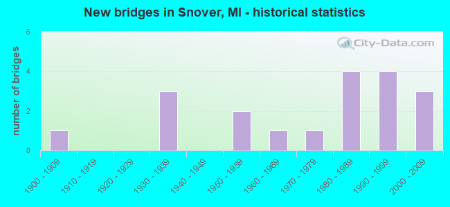
- New bridges - historical statistics
- 11900-1909
- 31930-1939
- 21950-1959
- 11960-1969
- 11970-1979
- 41980-1989
- 41990-1999
- 32000-2009

- Reconstructed bridges - Historical Statistics
- 11970-1979
- 11980-1989


- Bridge Condition - Deck
- 43.8%Good
- 31.3%Satisfactory
- 25.0%Fair

- Bridge Condition - Superstructure
- 6.3%Very good
- 50.0%Good
- 18.8%Satisfactory
- 25.0%Fair

- Bridge Condition - Substructure
- 62.5%Good
- 6.3%Satisfactory
- 31.3%Fair

- Bridge Condition - Channel
- 31.6%Very good
- 42.1%Good
- 21.1%Satisfactory
- 5.3%Fair

- Bridge Condition - Culverts
- 33.3%Very good
- 66.7%Satisfactory
Find on map >> Show street view
Structure Number: 947, Location: 6.7 MI N OF M-46 (Lat: 43.515839, Lng: -82.933500), Route carried "on" structure: State highway 19, Year Built: 2007, Status: Open, Structure Length: 0.91m (2.99ft), Average Daily Traffic: 1,718 (year 2007), Truck Traffic: 9%, Average Future Daily Traffic: 2,150 (year 2027), Design Load: HS 25 or greater, Features Intersected: BR CASS RIVER
Minimum Vertical Clearance: 30.48m (100.00ft), Kilometerpoint: 10.781, Lanes on structure: 2, Base Highway Network: Yes (Inventory Route: 101, Subroute: 6), Owner: State Highway Agency, Approaching Roadway Width: 12.5m (41.0ft), Material/Design: Concrete, Design/Construction: Culvert, Number Of Spans In Main Unit: 1, Length of Maximum Span: 8.5m (27.9ft), Curb-To-Curb Width: 13.4m (44.0ft), Out-to-Out Width: 14.4m (47.2ft)
Condition: Channel: Good, Culverts: Very good, Operating Rating: 44.1 metric tons, Method Used To Determine Operating Rating: Load Factor (LF) rating reported by rating factor (RF) method using MS18 loading, Inventory Rating: 26.6 metric tons, Method Used To Determine Inventory Rating: Load Factor (LF) rating reported by rating factor (RF) method using MS18 loading, Structural Evaluation: Equal to present minimum criteria, Deck Geometry: Equal to present desirable criteria, Waterway Adequacy: Equal to present desirable criteria, Approach Roadway Alignment: Equal to present minimum criteria, Designated Inspection Frequency: Every 24 months, Inspection Date: September 2021, Deck Structure Type: Concrete Cast-file-Place, Wearing Surface/Protective System: Wearing Surface: Bituminous
Find on map >> Show street view
Structure Number: 9471, Location: 7.8 MI N OF M-46 (Lat: 43.531958, Lng: -82.934208), Route carried "on" structure: State highway 19, Year Built: 1952, Status: Open, Structure Length: 1.06m (3.48ft), Average Daily Traffic: 1,718 (year 2007), Truck Traffic: 10%, Average Future Daily Traffic: 2,396 (year 2018), Design Load: HS 20, Features Intersected: MIDDLE BR CASS RIVER
Minimum Vertical Clearance: 30.48m (100.00ft), Kilometerpoint: 12.573, Lanes on structure: 2, Base Highway Network: Yes (Inventory Route: 101, Subroute: 6), Owner: State Highway Agency, Approaching Roadway Width: 13.1m (43.0ft), Material/Design: Concrete, Design/Construction: Tee Beam, Number Of Spans In Main Unit: 1, Length of Maximum Span: 10.6m (34.8ft), Curb or Sidewalk Widths: Left: 0.4m (1.3ft), Right: 0.4m (1.3ft), Curb-To-Curb Width: 11.5m (37.7ft), Out-to-Out Width: 13.3m (43.6ft)
Condition: Deck: Fair, Superstructure: Fair, Substructure: Fair, Channel: Very good, Operating Rating: 41.1 metric tons, Method Used To Determine Operating Rating: Load Factor (LF) rating reported by rating factor (RF) method using MS18 loading, Inventory Rating: 24.6 metric tons, Method Used To Determine Inventory Rating: Load Factor (LF) rating reported by rating factor (RF) method using MS18 loading, Structural Evaluation: Somewhat better than minimum adequacy, Deck Geometry: Equal to present minimum criteria, Waterway Adequacy: Equal to present desirable criteria, Approach Roadway Alignment: Somewhat better than minimum adequacy, Designated Inspection Frequency: Every 24 months, Inspection Date: June 2020, Deck Structure Type: Concrete Cast-file-Place, Wearing Surface/Protective System: Wearing Surface: Bituminous, Membrane: Other
Find on map >> Show street view
Structure Number: 9472, Location: 8.1 MI N OF M-46 (Lat: 43.536392, Lng: -82.934447), Route carried "on" structure: State highway 19, Year Built: 1952, Status: Open, Structure Length: 1.06m (3.48ft), Average Daily Traffic: 1,718 (year 2007), Truck Traffic: 10%, Average Future Daily Traffic: 2,396 (year 2018), Design Load: HS 20, Features Intersected: BR CASS RIVER
Minimum Vertical Clearance: 30.48m (100.00ft), Kilometerpoint: 13.065, Lanes on structure: 2, Base Highway Network: Yes (Inventory Route: 101, Subroute: 6), Owner: State Highway Agency, Approaching Roadway Width: 12.8m (42.0ft), Material/Design: Concrete, Design/Construction: Tee Beam, Number Of Spans In Main Unit: 1, Length of Maximum Span: 10.6m (34.8ft), Curb or Sidewalk Widths: Left: 0.4m (1.3ft), Right: 0.4m (1.3ft), Curb-To-Curb Width: 11.5m (37.7ft), Out-to-Out Width: 13.2m (43.3ft)
Condition: Deck: Fair, Superstructure: Fair, Substructure: Good, Channel: Satisfactory, Operating Rating: 41.1 metric tons, Method Used To Determine Operating Rating: Load Factor (LF) rating reported by rating factor (RF) method using MS18 loading, Inventory Rating: 24.6 metric tons, Method Used To Determine Inventory Rating: Load Factor (LF) rating reported by rating factor (RF) method using MS18 loading, Structural Evaluation: Somewhat better than minimum adequacy, Deck Geometry: Equal to present minimum criteria, Waterway Adequacy: Equal to present desirable criteria, Approach Roadway Alignment: Equal to present minimum criteria, Designated Inspection Frequency: Every 24 months, Inspection Date: June 2020, Deck Structure Type: Concrete Cast-file-Place, Wearing Surface/Protective System: Wearing Surface: Bituminous, Membrane: Other
Find on map >> Show street view
Structure Number: 9477, Location: 2.0 MI W OF M-19 (Lat: 43.417717, Lng: -82.968150), Route carried "on" structure: State highway 46, Year Built: 2007, Status: Open, Structure Length: 4.12m (13.52ft), Average Daily Traffic: 3,484 (year 2007), Truck Traffic: 16%, Average Future Daily Traffic: 6,050 (year 2027), Design Load: HS 25 or greater, Features Intersected: S BR CASS RIVER
Minimum Vertical Clearance: 30.48m (100.00ft), Kilometerpoint: 11.190, Lanes on structure: 2, Base Highway Network: Yes (Inventory Route: 101, Subroute: 6), Owner: State Highway Agency, Approaching Roadway Width: 12.8m (42.0ft), Skew: 4 degrees, Material/Design: Prestressed concrete, Design/Construction: Stringer/Multi-beam, Number Of Spans In Main Unit: 3, Length of Maximum Span: 18.0m (59.1ft), Curb-To-Curb Width: 17.7m (58.1ft), Out-to-Out Width: 18.6m (61.0ft)
Condition: Deck: Good, Superstructure: Very good, Substructure: Good, Channel: Very good, Operating Rating: 80.7 metric tons, Method Used To Determine Operating Rating: Load Factor (LF) rating reported by rating factor (RF) method using MS18 loading, Inventory Rating: 43.1 metric tons, Method Used To Determine Inventory Rating: Load Factor (LF) rating reported by rating factor (RF) method using MS18 loading, Structural Evaluation: Better than present minimum criteria, Deck Geometry: Superior to present desirable criteria, Waterway Adequacy: Equal to present desirable criteria, Approach Roadway Alignment: Equal to present desirable criteria, Designated Inspection Frequency: Every 24 months, Inspection Date: September 2020, Deck Structure Type: Concrete Cast-file-Place, Wearing Surface/Protective System: Wearing Surface: Monolithic Concrete, Deck Protection: Epoxy Coated Reinforcing
Find on map >> Show street view
Structure Number: 9535, Location: SEC 18-19 MOORE TWP (Lat: 43.460858, Lng: -82.984636), Route carried "on" structure: County highway 7460, Year Built: 1983, Status: Open, Structure Length: 2.53m (8.30ft), Average Daily Traffic: 967 (year 2016), Truck Traffic: 10%, Average Future Daily Traffic: 1,437 (year 2036), Design Load: HS 20, Features Intersected: S BR CASS RIVER I/C DRN, Facility Carried by Structure: SNOVER ROAD
Minimum Vertical Clearance: 30.48m (100.00ft), Kilometerpoint: 12.370, Lanes on structure: 2, Owner: County Highway Agency, Approaching Roadway Width: 9.1m (29.9ft), Material/Design: Prestressed concrete, Design/Construction: Box Beam or Girders - Multiple, Number Of Spans In Main Unit: 1, Length of Maximum Span: 24.3m (79.7ft), Curb-To-Curb Width: 9.9m (32.5ft), Out-to-Out Width: 10.5m (34.4ft)
Condition: Deck: Good, Superstructure: Good, Substructure: Good, Channel: Very good, Operating Rating: 54.4 metric tons, Method Used To Determine Operating Rating: Load and Resistance Factor Rating (LRFR) rating reported by rating factor(RF) method using HL-93 loadings, Inventory Rating: 39.2 metric tons, Method Used To Determine Inventory Rating: Load and Resistance Factor Rating (LRFR) rating reported by rating factor(RF) method using HL-93 loadings, Structural Evaluation: Better than present minimum criteria, Deck Geometry: Equal to present minimum criteria, Waterway Adequacy: Better than present minimum criteria, Approach Roadway Alignment: Equal to present desirable criteria, Designated Inspection Frequency: Every 24 months, Inspection Date: April 2020, Deck Structure Type: Concrete Precast Panels, Wearing Surface/Protective System: Wearing Surface: Bituminous, Membrane: Preformed Fabric, Deck Protection: Epoxy Coated Reinforcing
Find on map >> Show street view
Structure Number: 9538, Location: SEC 27-34 EVERGREEN TWP (Lat: 43.517433, Lng: -83.038964), Route carried "on" structure: County highway 7470, Year Built: 1930, Status: Open, Structure Length: 2.23m (7.32ft), Average Daily Traffic: 1,023 (year 2016), Truck Traffic: 20%, Average Future Daily Traffic: 1,847 (year 2036), Design Load: H 15, Features Intersected: S BR CASS RIVER I/C DRN, Facility Carried by Structure: DECKERVILLE ROAD
Minimum Vertical Clearance: 30.48m (100.00ft), Kilometerpoint: 5.771, Lanes on structure: 2, Owner: County Highway Agency, Approaching Roadway Width: 9.8m (32.2ft), Material/Design: Steel, Design/Construction: Stringer/Multi-beam, Number Of Spans In Main Unit: 2, Length of Maximum Span: 10.7m (35.1ft), Curb-To-Curb Width: 10.0m (32.8ft), Out-to-Out Width: 10.5m (34.4ft)
Condition: Deck: Satisfactory, Superstructure: Good, Substructure: Fair, Channel: Very good, Operating Rating: 53.8 metric tons, Method Used To Determine Operating Rating: Load and Resistance Factor Rating (LRFR) rating reported by rating factor(RF) method using HL-93 loadings, Inventory Rating: 32.4 metric tons, Method Used To Determine Inventory Rating: Load and Resistance Factor Rating (LRFR) rating reported by rating factor(RF) method using HL-93 loadings, Structural Evaluation: Somewhat better than minimum adequacy, Deck Geometry: Somewhat better than minimum adequacy, Waterway Adequacy: Equal to present minimum criteria, Approach Roadway Alignment: Equal to present desirable criteria, Length Of Structure Improvement: 2.72m (8.92ft), Designated Inspection Frequency: Every 24 months, Inspection Date: June 2020, Bridge Improvement Cost: $467,000, Roadway Improvement Cost: $70,000, Total Project Cost: $695,000, Deck Structure Type: Concrete Cast-file-Place, Wearing Surface/Protective System: Wearing Surface: Bituminous, Membrane: Preformed Fabric
Find on map >> Show street view
Structure Number: 9539, Location: SEC 26-35 ARGYLE TWP (Lat: 43.521811, Lng: -82.907042), Route carried "on" structure: County highway 7470, Year Built: 1992, Status: Open, Structure Length: 1.89m (6.20ft), Average Daily Traffic: 1,825 (year 2016), Truck Traffic: 20%, Average Future Daily Traffic: 3,300 (year 2036), Design Load: HS 20, Features Intersected: MIDDLE BR DRAIN, Facility Carried by Structure: DECKERVILLE ROAD
Minimum Vertical Clearance: 30.48m (100.00ft), Kilometerpoint: 16.448, Lanes on structure: 2, Owner: County Highway Agency, Approaching Roadway Width: 10.4m (34.1ft), Skew: 2 degrees, Material/Design: Prestressed concrete, Design/Construction: Box Beam or Girders - Multiple, Number Of Spans In Main Unit: 1, Length of Maximum Span: 18.4m (60.4ft), Curb-To-Curb Width: 10.0m (32.8ft), Out-to-Out Width: 10.5m (34.4ft)
Condition: Deck: Good, Superstructure: Satisfactory, Substructure: Good, Channel: Good, Operating Rating: 70.2 metric tons, Method Used To Determine Operating Rating: Load Factor (LF), Inventory Rating: 42.1 metric tons, Method Used To Determine Inventory Rating: Load Factor (LF), Structural Evaluation: Equal to present minimum criteria, Deck Geometry: Somewhat better than minimum adequacy, Waterway Adequacy: Superior to present desirable criteria, Approach Roadway Alignment: Equal to present desirable criteria, Designated Inspection Frequency: Every 24 months, Inspection Date: April 2020, Deck Structure Type: Concrete Cast-file-Place, Wearing Surface/Protective System: Wearing Surface: Bituminous, Membrane: Preformed Fabric
Find on map >> Show street view
Structure Number: 9552, Location: SEC 1-2 LAMOTTE TWP (Lat: 43.494586, Lng: -83.012264), Route carried "on" structure: County highway 7419, Year Built: 1983, Status: Open, Structure Length: 2.87m (9.42ft), Average Daily Traffic: 437 (year 2014), Truck Traffic: 10%, Average Future Daily Traffic: 790 (year 2034), Design Load: HS 20, Features Intersected: S BR CASS RIVER I/C DRN, Facility Carried by Structure: GERMANIA ROAD
Minimum Vertical Clearance: 30.48m (100.00ft), Kilometerpoint: 18.355, Lanes on structure: 2, Owner: County Highway Agency, Approaching Roadway Width: 9.4m (30.8ft), Skew: 2 degrees, Material/Design: Prestressed concrete, Design/Construction: Box Beam or Girders - Multiple, Number Of Spans In Main Unit: 1, Length of Maximum Span: 28.1m (92.2ft), Curb-To-Curb Width: 9.4m (30.8ft), Out-to-Out Width: 9.6m (31.5ft)
Condition: Deck: Satisfactory, Superstructure: Fair, Substructure: Good, Channel: Good, Operating Rating: 74.3 metric tons, Method Used To Determine Operating Rating: Load Factor (LF), Inventory Rating: 44.7 metric tons, Method Used To Determine Inventory Rating: Load Factor (LF), Structural Evaluation: Somewhat better than minimum adequacy, Deck Geometry: Equal to present minimum criteria, Waterway Adequacy: Better than present minimum criteria, Approach Roadway Alignment: Equal to present desirable criteria, Designated Inspection Frequency: Every 24 months, Inspection Date: May 2020, Deck Structure Type: Concrete Precast Panels, Wearing Surface/Protective System: Wearing Surface: Bituminous, Membrane: Preformed Fabric, Deck Protection: Epoxy Coated Reinforcing
Find on map >> Show street view
Structure Number: 9562, Location: SEC 35 ARGYLE TWP (Lat: 43.507392, Lng: -82.903392), Route carried "on" structure: County highway , Year Built: 1969, Status: Open, Structure Length: 0.82m (2.69ft), Average Daily Traffic: 180 (year 2010), Truck Traffic: 10%, Average Future Daily Traffic: 325 (year 2030), Design Load: H 20, Features Intersected: MIDDLE BR DRAIN, Facility Carried by Structure: DOWNINGTON ROAD
Minimum Vertical Clearance: 30.48m (100.00ft), Kilometerpoint: 16.683, Lanes on structure: 2, Owner: County Highway Agency, Approaching Roadway Width: 9.1m (29.9ft), Material/Design: Steel, Design/Construction: Culvert, Number Of Spans In Main Unit: 1, Length of Maximum Span: 8.2m (26.9ft), Curb-To-Curb Width: 6.1m (20.0ft), Out-to-Out Width: 9.8m (32.2ft)
Condition: Channel: Satisfactory, Culverts: Satisfactory, Operating Rating: 46.0 metric tons, Method Used To Determine Operating Rating: Load Factor (LF) rating reported by rating factor (RF) method using MS18 loading, Inventory Rating: 27.5 metric tons, Method Used To Determine Inventory Rating: Load Factor (LF) rating reported by rating factor (RF) method using MS18 loading, Structural Evaluation: Equal to present minimum criteria, Deck Geometry: Meets minimum limits, Waterway Adequacy: Equal to present desirable criteria, Approach Roadway Alignment: Equal to present minimum criteria, Designated Inspection Frequency: Every 24 months, Inspection Date: April 2020
Find on map >> Show street view
Structure Number: 9564, Location: SEC 21-28 ARGYLE TWP (Lat: 43.534725, Lng: -82.949919), Route carried "on" structure: ServiceCounty highway , Year Built: 1993, Status: Open, Structure Length: 1.65m (5.41ft), Average Daily Traffic: 180 (year 2016), Truck Traffic: 10%, Average Future Daily Traffic: 325 (year 2036), Design Load: HS 20, Features Intersected: MIDDLE BR DRAIN, Facility Carried by Structure: SHABBONA ROAD
Minimum Vertical Clearance: 30.48m (100.00ft), Kilometerpoint: 13.041, Lanes on structure: 2, Owner: County Highway Agency, Approaching Roadway Width: 8.5m (27.9ft), Material/Design: Wood or Timber, Design/Construction: Slab, Number Of Spans In Main Unit: 3, Length of Maximum Span: 8.8m (28.9ft), Curb-To-Curb Width: 9.2m (30.2ft), Out-to-Out Width: 9.8m (32.2ft)
Condition: Deck: Good, Superstructure: Good, Substructure: Good, Channel: Good, Operating Rating: 70.6 metric tons, Method Used To Determine Operating Rating: Allowable Stress (AS) rating reported by rating factor (RF) method using MS18 loading, Inventory Rating: 49.9 metric tons, Method Used To Determine Inventory Rating: Allowable Stress (AS) rating reported by rating factor (RF) method using MS18 loading, Structural Evaluation: Better than present minimum criteria, Deck Geometry: Equal to present minimum criteria, Waterway Adequacy: Equal to present desirable criteria, Approach Roadway Alignment: Equal to present desirable criteria, Designated Inspection Frequency: Every 24 months, Inspection Date: April 2020, Deck Structure Type: Wood or Timber, Wearing Surface/Protective System: Wearing Surface: Bituminous
Find on map >> Show street view
Structure Number: 9565, Location: SEC 13-18 ARGYLE TWP (Lat: 43.548464, Lng: -82.994839), Route carried "on" structure: County highway , Year Built: 1907, Year Reconstructed: 1980, Status: Posted for load, Structure Length: 1.22m (4.00ft), Average Daily Traffic: 150 (year 2010), Truck Traffic: 7%, Average Future Daily Traffic: 270 (year 2030), Design Load: H 20, Features Intersected: MIDDLE BR CASS RIVER, Facility Carried by Structure: ARNOLD ROAD
Minimum Vertical Clearance: 30.48m (100.00ft), Kilometerpoint: 14.599, Lanes on structure: 2, Owner: County Highway Agency, Approaching Roadway Width: 7.3m (24.0ft), Material/Design: Prestressed concrete, Design/Construction: Tee Beam, Number Of Spans In Main Unit: 1, Length of Maximum Span: 11.8m (38.7ft), Curb-To-Curb Width: 6.1m (20.0ft), Out-to-Out Width: 6.9m (22.6ft)
Condition: Deck: Good, Superstructure: Good, Substructure: Fair, Channel: Satisfactory, Operating Rating: 60.7 metric tons, Method Used To Determine Operating Rating: Load Factor (LF), Inventory Rating: 36.2 metric tons, Method Used To Determine Inventory Rating: Load Factor (LF), Structural Evaluation: Somewhat better than minimum adequacy, Deck Geometry: Meets minimum limits, Waterway Adequacy: Equal to present desirable criteria, Approach Roadway Alignment: Equal to present minimum criteria, Bridge Posting: Required (Relationship of Operating Rating to Maximum Legal Load: 20.0 - 29.9% below), Designated Inspection Frequency: Every 24 months, Inspection Date: June 2020, Deck Structure Type: Concrete Precast Panels, Wearing Surface/Protective System: Wearing Surface: Bituminous
Find on map >> Show street view
Structure Number: 9566, Location: SEC 19-20 ARGYLE TWP (Lat: 43.544922, Lng: -82.974800), Route carried "on" structure: County highway , Year Built: 1981, Status: Open, Structure Length: 1.23m (4.04ft), Average Daily Traffic: 190 (year 2016), Truck Traffic: 10%, Average Future Daily Traffic: 340 (year 2036), Design Load: HS 20+Mod, Features Intersected: MIDDLE BR CASS RIVER DRN, Facility Carried by Structure: WHEELER ROAD
Minimum Vertical Clearance: 30.48m (100.00ft), Kilometerpoint: 14.155, Lanes on structure: 2, Owner: County Highway Agency, Approaching Roadway Width: 9.8m (32.2ft), Material/Design: Steel, Design/Construction: Stringer/Multi-beam, Number Of Spans In Main Unit: 1, Length of Maximum Span: 11.6m (38.1ft), Curb-To-Curb Width: 7.8m (25.6ft), Out-to-Out Width: 8.0m (26.2ft)
Condition: Deck: Satisfactory, Superstructure: Satisfactory, Substructure: Good, Channel: Fair, Operating Rating: 80.2 metric tons, Method Used To Determine Operating Rating: Load Factor (LF), Inventory Rating: 48.1 metric tons, Method Used To Determine Inventory Rating: Load Factor (LF), Structural Evaluation: Equal to present minimum criteria, Deck Geometry: Somewhat better than minimum adequacy, Waterway Adequacy: Equal to present desirable criteria, Approach Roadway Alignment: Equal to present desirable criteria, Designated Inspection Frequency: Every 24 months, Inspection Date: April 2020, Deck Structure Type: Concrete Cast-file-Place, Wearing Surface/Protective System: Wearing Surface: Monolithic Concrete
Find on map >> Show street view
Structure Number: 9567, Location: SEC 26-27 ARGYLE TWP (Lat: 43.527922, Lng: -82.913983), Route carried "on" structure: County highway , Year Built: 1970, Status: Open, Structure Length: 0.85m (2.79ft), Average Daily Traffic: 200 (year 2016), Truck Traffic: 10%, Average Future Daily Traffic: 360 (year 2036), Design Load: H 20, Features Intersected: MIDDLE BR DRAIN, Facility Carried by Structure: FREIBERGER ROAD
Minimum Vertical Clearance: 30.48m (100.00ft), Kilometerpoint: 12.066, Lanes on structure: 2, Owner: County Highway Agency, Approaching Roadway Width: 8.5m (27.9ft), Material/Design: Steel, Design/Construction: Culvert, Number Of Spans In Main Unit: 1, Length of Maximum Span: 8.5m (27.9ft), Curb-To-Curb Width: 7.3m (24.0ft), Out-to-Out Width: 12.2m (40.0ft)
Condition: Channel: Good, Culverts: Satisfactory, Operating Rating: 55.1 metric tons, Method Used To Determine Operating Rating: Load Factor (LF) rating reported by rating factor (RF) method using MS18 loading, Inventory Rating: 33.0 metric tons, Method Used To Determine Inventory Rating: Load Factor (LF) rating reported by rating factor (RF) method using MS18 loading, Structural Evaluation: Equal to present minimum criteria, Deck Geometry: Somewhat better than minimum adequacy, Waterway Adequacy: Equal to present desirable criteria, Approach Roadway Alignment: Equal to present minimum criteria, Designated Inspection Frequency: Every 24 months, Inspection Date: April 2020
Find on map >> Show street view
Structure Number: 9608, Location: SEC 35 EVERGREEN TWP (Lat: 43.503183, Lng: -83.028244), Route carried "on" structure: ServiceCounty highway , Year Built: 1999, Status: Open, Structure Length: 3.32m (10.89ft), Average Daily Traffic: 160 (year 2010), Truck Traffic: 10%, Average Future Daily Traffic: 290 (year 2030), Design Load: HS 20, Features Intersected: S BR CASS RIVER I/C DRN, Facility Carried by Structure: DOWNINGTON ROAD
Minimum Vertical Clearance: 30.48m (100.00ft), Kilometerpoint: 6.574, Lanes on structure: 2, Owner: County Highway Agency, Approaching Roadway Width: 9.1m (29.9ft), Skew: 1 degrees, Material/Design: Prestressed concrete, Design/Construction: Box Beam or Girders - Multiple, Number Of Spans In Main Unit: 3, Length of Maximum Span: 13.6m (44.6ft), Curb-To-Curb Width: 8.7m (28.5ft), Out-to-Out Width: 9.5m (31.2ft)
Condition: Deck: Satisfactory, Superstructure: Satisfactory, Substructure: Satisfactory, Channel: Good, Operating Rating: 73.8 metric tons, Method Used To Determine Operating Rating: Load Factor (LF), Inventory Rating: 44.4 metric tons, Method Used To Determine Inventory Rating: Load Factor (LF), Structural Evaluation: Equal to present minimum criteria, Deck Geometry: Equal to present minimum criteria, Waterway Adequacy: Equal to present desirable criteria, Approach Roadway Alignment: Equal to present desirable criteria, Designated Inspection Frequency: Every 24 months, Inspection Date: June 2020, Deck Structure Type: Concrete Precast Panels, Wearing Surface/Protective System: Wearing Surface: Bituminous, Membrane: Built-up
Find on map >> Show street view
Structure Number: 9612, Location: SEC 34-35 EVERGREEN TWP (Lat: 43.508000, Lng: -83.032700), Route carried "on" structure: County highway , Year Built: 1991, Status: Open, Structure Length: 2.74m (8.99ft), Average Daily Traffic: 115 (year 2010), Average Future Daily Traffic: 210 (year 2030), Design Load: HS 20, Features Intersected: S BR CASS RIVER I/C DRN, Facility Carried by Structure: LESLIE ROAD
Minimum Vertical Clearance: 30.48m (100.00ft), Kilometerpoint: 6.352, Lanes on structure: 2, Owner: County Highway Agency, Approaching Roadway Width: 7.9m (25.9ft), Material/Design: Prestressed concrete, Design/Construction: Box Beam or Girders - Multiple, Number Of Spans In Main Unit: 1, Length of Maximum Span: 26.9m (88.3ft), Curb-To-Curb Width: 9.2m (30.2ft), Out-to-Out Width: 9.6m (31.5ft)
Condition: Deck: Fair, Superstructure: Good, Substructure: Good, Channel: Very good, Operating Rating: 80.7 metric tons, Method Used To Determine Operating Rating: Load Factor (LF), Inventory Rating: 48.3 metric tons, Method Used To Determine Inventory Rating: Load Factor (LF), Structural Evaluation: Better than present minimum criteria, Deck Geometry: Equal to present minimum criteria, Waterway Adequacy: Equal to present desirable criteria, Approach Roadway Alignment: Equal to present desirable criteria, Designated Inspection Frequency: Every 24 months, Inspection Date: June 2020, Deck Structure Type: Concrete Precast Panels, Wearing Surface/Protective System: Wearing Surface: Bituminous, Membrane: Other
Find on map >> Show street view
Structure Number: 9633, Location: SEC 1-12 LAMOTTE TWP (Lat: 43.489617, Lng: -82.995367), Route carried "on" structure: County highway , Year Built: 2001, Status: Open, Structure Length: 3.57m (11.71ft), Average Daily Traffic: 155 (year 2010), Truck Traffic: 10%, Average Future Daily Traffic: 280 (year 2030), Design Load: HS 20+Mod, Features Intersected: S BR CASS RIVER I/C DRN, Facility Carried by Structure: MUSHROOM ROAD
Minimum Vertical Clearance: 30.48m (100.00ft), Kilometerpoint: 9.193, Lanes on structure: 2, Owner: County Highway Agency, Approaching Roadway Width: 9.1m (29.9ft), Material/Design: Prestressed concrete, Design/Construction: Box Beam or Girders - Multiple, Number Of Spans In Main Unit: 2, Length of Maximum Span: 17.8m (58.4ft), Curb-To-Curb Width: 8.7m (28.5ft), Out-to-Out Width: 9.5m (31.2ft)
Condition: Deck: Good, Superstructure: Good, Substructure: Good, Channel: Good, Operating Rating: 73.2 metric tons, Method Used To Determine Operating Rating: Load Factor (LF) rating reported by rating factor (RF) method using MS18 loading, Inventory Rating: 43.7 metric tons, Method Used To Determine Inventory Rating: Load Factor (LF) rating reported by rating factor (RF) method using MS18 loading, Structural Evaluation: Better than present minimum criteria, Deck Geometry: Equal to present minimum criteria, Waterway Adequacy: Meets minimum limits, Approach Roadway Alignment: Somewhat better than minimum adequacy, Designated Inspection Frequency: Every 24 months, Inspection Date: May 2020, Deck Structure Type: Concrete Precast Panels, Wearing Surface/Protective System: Wearing Surface: Bituminous, Membrane: Preformed Fabric, Deck Protection: Epoxy Coated Reinforcing
Find on map >> Show street view
Structure Number: 9642, Location: SEC 31 MOORE TWP (Lat: 43.424408, Lng: -82.975825), Route carried "on" structure: County highway , Year Built: 1930, Year Reconstructed: 1982, Status: Open, Structure Length: 1.92m (6.30ft), Average Daily Traffic: 150 (year 2016), Truck Traffic: 10%, Average Future Daily Traffic: 270 (year 2036), Design Load: H 20, Features Intersected: S BR CASS RIVER I/C DRN, Facility Carried by Structure: MOORE ROAD
Minimum Vertical Clearance: 30.48m (100.00ft), Kilometerpoint: 2.730, Lanes on structure: 2, Owner: County Highway Agency, Approaching Roadway Width: 7.9m (25.9ft), Material/Design: Steel, Design/Construction: Stringer/Multi-beam, Number Of Spans In Main Unit: 1, Length of Maximum Span: 18.7m (61.4ft), Curb-To-Curb Width: 7.7m (25.3ft), Out-to-Out Width: 7.9m (25.9ft)
Condition: Deck: Good, Superstructure: Good, Substructure: Fair, Channel: Very good, Operating Rating: 59.7 metric tons, Method Used To Determine Operating Rating: Load Factor (LF), Inventory Rating: 35.7 metric tons, Method Used To Determine Inventory Rating: Load Factor (LF), Structural Evaluation: Somewhat better than minimum adequacy, Deck Geometry: Somewhat better than minimum adequacy, Waterway Adequacy: Equal to present minimum criteria, Approach Roadway Alignment: Equal to present minimum criteria, Designated Inspection Frequency: Every 24 months, Inspection Date: April 2020, Bridge Improvement Cost: $9,000, Roadway Improvement Cost: $2,000, Total Project Cost: $11,000, Deck Structure Type: Concrete Cast-file-Place, Wearing Surface/Protective System: Wearing Surface: Monolithic Concrete, Deck Protection: Epoxy Coated Reinforcing
Find on map >> Show street view
Structure Number: 9644, Location: SEC 7 MOORE TWP (Lat: 43.485283, Lng: -82.991817), Route carried "on" structure: County highway , Year Built: 1988, Status: Open, Structure Length: 2.87m (9.42ft), Average Daily Traffic: 225 (year 2016), Truck Traffic: 10%, Average Future Daily Traffic: 405 (year 2036), Design Load: HS 20, Features Intersected: S BR CASS RIVER I/C DRN, Facility Carried by Structure: ARNOLD ROAD
Minimum Vertical Clearance: 30.48m (100.00ft), Kilometerpoint: 7.575, Lanes on structure: 2, Owner: County Highway Agency, Approaching Roadway Width: 10.4m (34.1ft), Material/Design: Prestressed concrete, Design/Construction: Box Beam or Girders - Multiple, Number Of Spans In Main Unit: 1, Length of Maximum Span: 28.1m (92.2ft), Curb-To-Curb Width: 9.2m (30.2ft), Out-to-Out Width: 9.5m (31.2ft)
Condition: Deck: Satisfactory, Superstructure: Good, Substructure: Good, Channel: Good, Operating Rating: 90.1 metric tons, Method Used To Determine Operating Rating: Load Factor (LF), Inventory Rating: 61.8 metric tons, Method Used To Determine Inventory Rating: Load Factor (LF), Structural Evaluation: Better than present minimum criteria, Deck Geometry: Equal to present minimum criteria, Waterway Adequacy: Equal to present desirable criteria, Approach Roadway Alignment: Equal to present desirable criteria, Designated Inspection Frequency: Every 24 months, Inspection Date: April 2020, Deck Structure Type: Concrete Precast Panels, Wearing Surface/Protective System: Wearing Surface: Bituminous, Membrane: Preformed Fabric, Deck Protection: Epoxy Coated Reinforcing
Find on map >> Show street view
Structure Number: 9645, Location: SEC 1-2 MOORE TWP (Lat: 43.502289, Lng: -82.892917), Route carried "on" structure: County highway , Year Built: 1930, Status: Open, Structure Length: 0.70m (2.30ft), Average Daily Traffic: 150 (year 2016), Truck Traffic: 10%, Average Future Daily Traffic: 270 (year 2036), Design Load: H 15, Features Intersected: BRICE DRAIN, Facility Carried by Structure: SHELDEN ROAD
Minimum Vertical Clearance: 30.48m (100.00ft), Kilometerpoint: 4.294, Lanes on structure: 2, Owner: County Highway Agency, Approaching Roadway Width: 6.7m (22.0ft), Material/Design: Steel, Design/Construction: Stringer/Multi-beam, Number Of Spans In Main Unit: 1, Length of Maximum Span: 6.1m (20.0ft), Curb-To-Curb Width: 6.1m (20.0ft), Out-to-Out Width: 6.2m (20.3ft)
Condition: Deck: Fair, Superstructure: Fair, Substructure: Fair, Channel: Satisfactory, Operating Rating: 46.5 metric tons, Method Used To Determine Operating Rating: Load Factor (LF), Inventory Rating: 27.8 metric tons, Method Used To Determine Inventory Rating: Load Factor (LF), Structural Evaluation: Somewhat better than minimum adequacy, Deck Geometry: Meets minimum limits, Waterway Adequacy: Meets minimum limits, Approach Roadway Alignment: Equal to present minimum criteria, Length Of Structure Improvement: 1.28m (4.20ft), Designated Inspection Frequency: Every 24 months, Inspection Date: April 2020, Bridge Improvement Cost: $210,000, Roadway Improvement Cost: $24,000, Total Project Cost: $255,000, Deck Structure Type: Concrete Cast-file-Place, Wearing Surface/Protective System: Wearing Surface: Monolithic Concrete