Bridge Statistics for Smyrna, Delaware (DE)
Condition, Traffic, Stress, Structural Evaluation, Project Costs
- National Bridge Inventory (NBI) Statistics
- 42Number of bridges
- 571ft / 174mTotal length
- $3,000,000Total costs
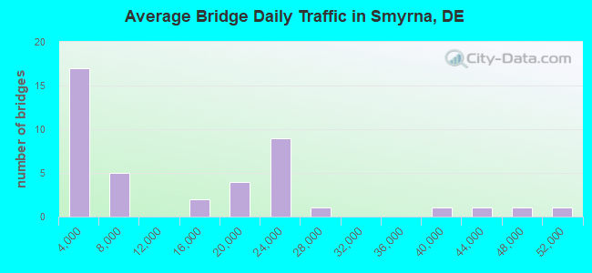
- 553,531Total average daily traffic
- 53,610Total average daily truck traffic
- National Bridge Inventory (NBI) Registered Bridges for Smyrna
- No street view available for this location
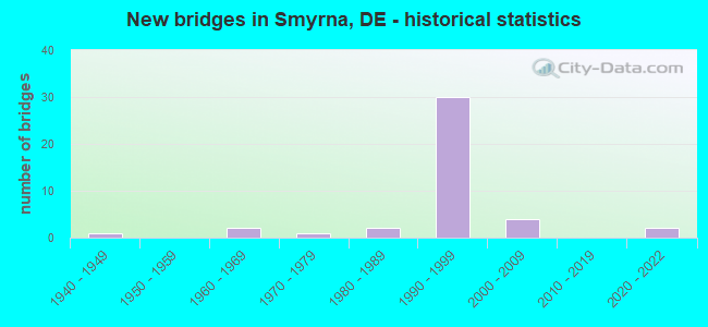
- New bridges - historical statistics
- 11940-1949
- 21960-1969
- 11970-1979
- 21980-1989
- 301990-1999
- 42000-2009
- 22020-2022
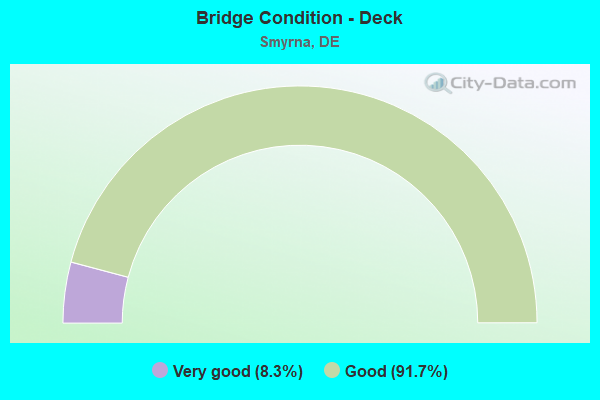
- Bridge Condition - Deck
- 8.3%Very good
- 91.7%Good
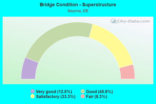
- Bridge Condition - Superstructure
- 12.5%Very good
- 45.8%Good
- 33.3%Satisfactory
- 8.3%Fair
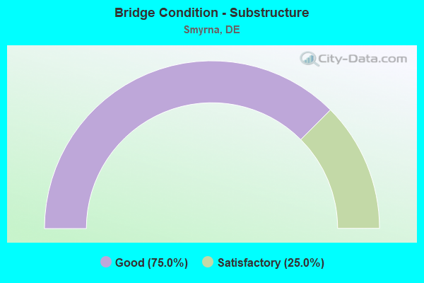
- Bridge Condition - Substructure
- 75.0%Good
- 25.0%Satisfactory
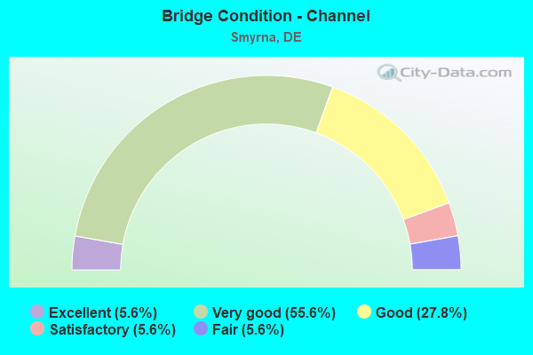
- Bridge Condition - Channel
- 5.6%Excellent
- 55.6%Very good
- 27.8%Good
- 5.6%Satisfactory
- 5.6%Fair
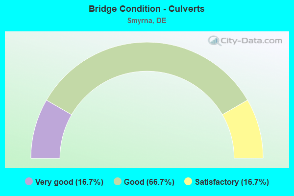
- Bridge Condition - Culverts
- 16.7%Very good
- 66.7%Good
- 16.7%Satisfactory
Find on map >> Show street view
Structure Number: 1454 465, Location: S/E OF BLACKBIRD (Lat: 39.360667, Lng: -75.621750), Route carried "on" structure: County highway 465, Year Built: 2020, Status: Open, Structure Length: 0.77m (2.53ft), Average Daily Traffic: 213 (year 2020), Truck Traffic: 10%, Average Future Daily Traffic: 264 (year 2043), Design Load: HS 20, Features Intersected: SAW MILL BRANCH, Facility Carried by Structure: EAGLES NEST LDG RD
Minimum Vertical Clearance: 30.48m (100.00ft), Kilometerpoint: 2.865, Lanes on structure: 2, Owner: State Highway Agency, Approaching Roadway Width: 6.1m (20.0ft), Skew: 1 degrees, Material/Design: Concrete, Design/Construction: Culvert, Number Of Spans In Main Unit: 3, Length of Maximum Span: 2.2m (7.2ft)
Condition: Channel: Good, Culverts: Good, Operating Rating: 54.4 metric tons, Method Used To Determine Operating Rating: Field evaluation and documented engineering judgment, Inventory Rating: 32.7 metric tons, Method Used To Determine Inventory Rating: Field evaluation and documented engineering judgment, Structural Evaluation: Better than present minimum criteria, Waterway Adequacy: Better than present minimum criteria, Approach Roadway Alignment: Equal to present desirable criteria, Designated Inspection Frequency: Every 24 months, Underwater Inspection Frequency: Every 48 months, Inspection Date: May 2021, Underwater Inspection Date: May 2021
Find on map >> Show street view
Structure Number: 1455 466, Location: EAST OF BLACKBIRD (Lat: 39.367433, Lng: -75.612961), Route carried "on" structure: County highway 466, Year Built: 2021, Status: Open, Structure Length: 0.67m (2.20ft), Average Daily Traffic: 114 (year 2020), Truck Traffic: 13%, Average Future Daily Traffic: 141 (year 2043), Design Load: HS 20, Features Intersected: SAW MILL BRANCH, Facility Carried by Structure: DEER RUN RD
Minimum Vertical Clearance: 30.48m (100.00ft), Kilometerpoint: 0.930, Lanes on structure: 2, Owner: State Highway Agency, Approaching Roadway Width: 6.1m (20.0ft), Material/Design: Concrete, Design/Construction: Culvert, Number Of Spans In Main Unit: 3, Length of Maximum Span: 1.8m (5.9ft)
Condition: Channel: Excellent, Culverts: Very good, Operating Rating: 54.4 metric tons, Method Used To Determine Operating Rating: Field evaluation and documented engineering judgment, Inventory Rating: 32.7 metric tons, Method Used To Determine Inventory Rating: Field evaluation and documented engineering judgment, Structural Evaluation: Equal to present desirable criteria, Waterway Adequacy: Equal to present desirable criteria, Approach Roadway Alignment: Equal to present desirable criteria, Designated Inspection Frequency: Every 24 months, Inspection Date: May 2021
Find on map >> Show street view
Structure Number: 1456 045, Location: EAST OF BLACKBIRD (Lat: 39.373669, Lng: -75.601144), Route carried "on" structure: County highway 45, Year Built: 1998, Status: Open, Structure Length: 1.79m (5.87ft), Average Daily Traffic: 439 (year 2019), Truck Traffic: 10%, Average Future Daily Traffic: 545 (year 2042), Design Load: HS 20, Features Intersected: SAW MILL BRANCH, Facility Carried by Structure: WALKER SCHOOL RD
Minimum Vertical Clearance: 30.48m (100.00ft), Kilometerpoint: 3.600, Lanes on structure: 2, Owner: State Highway Agency, Approaching Roadway Width: 6.2m (20.3ft), Material/Design: Prestressed concrete, Design/Construction: Box Beam or Girders - Multiple, Number Of Spans In Main Unit: 1, Length of Maximum Span: 17.0m (55.8ft), Curb-To-Curb Width: 9.1m (29.9ft), Out-to-Out Width: 10.2m (33.5ft)
Condition: Deck: Good, Superstructure: Good, Substructure: Good, Channel: Very good, Operating Rating: 67.7 metric tons, Method Used To Determine Operating Rating: Load and Resistance Factor Rating (LRFR) rating reported by rating factor(RF) method using HL-93 loadings, Inventory Rating: 52.8 metric tons, Method Used To Determine Inventory Rating: Load and Resistance Factor Rating (LRFR) rating reported by rating factor(RF) method using HL-93 loadings, Structural Evaluation: Better than present minimum criteria, Deck Geometry: Equal to present minimum criteria, Waterway Adequacy: Better than present minimum criteria, Approach Roadway Alignment: Equal to present desirable criteria, Designated Inspection Frequency: Every 24 months, Inspection Date: August 2020, Deck Structure Type: Concrete Cast-file-Place, Wearing Surface/Protective System: Wearing Surface: Monolithic Concrete, Deck Protection: Epoxy Coated Reinforcing
Find on map >> Show street view
Structure Number: 1457 03, Location: CHAMBERSVILLE (Lat: 39.365589, Lng: -75.577653), Route carried "on" structure: County highway 30, Year Built: 1961, Status: Open, Structure Length: 2.62m (8.60ft), Average Daily Traffic: 347 (year 2020), Truck Traffic: 13%, Average Future Daily Traffic: 431 (year 2043), Design Load: HS 20, Features Intersected: SAW MILL BRANCH, Facility Carried by Structure: PADDOCK RD.
Minimum Vertical Clearance: 30.48m (100.00ft), Kilometerpoint: 6.582, Lanes on structure: 2, Owner: State Highway Agency, Approaching Roadway Width: 7.3m (24.0ft), Material/Design: Prestressed concrete, Design/Construction: Box Beam or Girders - Multiple, Number Of Spans In Main Unit: 2, Length of Maximum Span: 12.6m (41.3ft), Curb-To-Curb Width: 9.1m (29.9ft), Out-to-Out Width: 11.2m (36.7ft)
Condition: Deck: Good, Superstructure: Satisfactory, Substructure: Satisfactory, Channel: Good, Operating Rating: 72.9 metric tons, Method Used To Determine Operating Rating: Load and Resistance Factor Rating (LRFR) rating reported by rating factor(RF) method using HL-93 loadings, Inventory Rating: 56.4 metric tons, Method Used To Determine Inventory Rating: Load and Resistance Factor Rating (LRFR) rating reported by rating factor(RF) method using HL-93 loadings, Structural Evaluation: Equal to present minimum criteria, Deck Geometry: Equal to present minimum criteria, Waterway Adequacy: Better than present minimum criteria, Approach Roadway Alignment: Equal to present desirable criteria, Designated Inspection Frequency: Every 24 months, Underwater Inspection Frequency: Every 48 months, Inspection Date: June 2021, Underwater Inspection Date: Febuary 2019, Deck Structure Type: Concrete Precast Panels, Wearing Surface/Protective System: Wearing Surface: Bituminous
Find on map >> Show street view
Structure Number: 1461 468, Location: N.E. OF SMYRNA (Lat: 39.340792, Lng: -75.584164), Route carried "on" structure: County highway 468, Year Built: 1994, Status: Open, Structure Length: 0.94m (3.08ft), Average Daily Traffic: 95 (year 2019), Truck Traffic: 10%, Average Future Daily Traffic: 118 (year 2042), Design Load: HS 25 or greater, Features Intersected: CORKS POINT DITCH, Facility Carried by Structure: MCQUAIL RD
Minimum Vertical Clearance: 30.48m (100.00ft), Kilometerpoint: 1.750, Lanes on structure: 2, Owner: State Highway Agency, Approaching Roadway Width: 6.2m (20.3ft), Material/Design: Prestressed concrete, Design/Construction: Box Beam or Girders - Multiple, Number Of Spans In Main Unit: 1, Length of Maximum Span: 9.1m (29.9ft), Curb-To-Curb Width: 9.8m (32.2ft), Out-to-Out Width: 10.8m (35.4ft)
Condition: Deck: Good, Superstructure: Very good, Substructure: Good, Channel: Very good, Operating Rating: 58.6 metric tons, Method Used To Determine Operating Rating: Load and Resistance Factor Rating (LRFR) rating reported by rating factor(RF) method using HL-93 loadings, Inventory Rating: 47.3 metric tons, Method Used To Determine Inventory Rating: Load and Resistance Factor Rating (LRFR) rating reported by rating factor(RF) method using HL-93 loadings, Structural Evaluation: Better than present minimum criteria, Deck Geometry: Equal to present desirable criteria, Waterway Adequacy: Equal to present desirable criteria, Approach Roadway Alignment: Equal to present desirable criteria, Length Of Structure Improvement: 0.94m (3.08ft), Designated Inspection Frequency: Every 24 months, Inspection Date: July 2020, Deck Structure Type: Concrete Cast-file-Place, Wearing Surface/Protective System: Wearing Surface: Monolithic Concrete, Deck Protection: Epoxy Coated Reinforcing
Find on map >> Show street view
Structure Number: 1464 03, Location: NORTH OF SMYRNA (Lat: 39.322208, Lng: -75.609656), Route carried "on" structure: County highway 30, Year Built: 1990, Status: Open, Structure Length: 6.51m (21.36ft), Average Daily Traffic: 2,952 (year 2020), Truck Traffic: 7%, Average Future Daily Traffic: 3,669 (year 2043), Design Load: HS 25 or greater, Features Intersected: SR 1, Facility Carried by Structure: PADDOCK RD.
Minimum Vertical Clearance: 30.48m (100.00ft), Kilometerpoint: 0.820, Lanes on structure: 2, Lanes under structure: 4, Owner: State Highway Agency, Approaching Roadway Width: 6.9m (22.6ft), Skew: 1 degrees, Material/Design: Steel continuous, Design/Construction: Stringer/Multi-beam, Number Of Spans In Main Unit: 2, Length of Maximum Span: 32.0m (105.0ft), Curb-To-Curb Width: 13.4m (44.0ft), Out-to-Out Width: 14.2m (46.6ft)
Condition: Deck: Good, Superstructure: Satisfactory, Substructure: Satisfactory, Operating Rating: 82.6 metric tons, Method Used To Determine Operating Rating: Load Factor (LF), Inventory Rating: 52.0 metric tons, Method Used To Determine Inventory Rating: Load Factor (LF), Structural Evaluation: Equal to present minimum criteria, Deck Geometry: Better than present minimum criteria, Underclear: Better than present minimum criteria, Approach Roadway Alignment: Equal to present desirable criteria, Designated Inspection Frequency: Every 24 months, Inspection Date: June 2021, Deck Structure Type: Concrete Cast-file-Place, Wearing Surface/Protective System: Wearing Surface: Monolithic Concrete, Deck Protection: Epoxy Coated Reinforcing
Find on map >> Show street view
Structure Number: 1471 047, Location: N. OF CLAYTON (Lat: 39.315397, Lng: -75.633622), Route carried "on" structure: County highway 47, Year Built: 1987, Status: Open, Structure Length: 1.19m (3.90ft), Average Daily Traffic: 2,203 (year 2020), Truck Traffic: 9%, Average Future Daily Traffic: 2,738 (year 2043), Design Load: HS 20, Features Intersected: GREENSPRING BRANCH, Facility Carried by Structure: VANDYKE-GREENSPRIN
Minimum Vertical Clearance: 30.48m (100.00ft), Kilometerpoint: 0.901, Lanes on structure: 2, Owner: State Highway Agency, Approaching Roadway Width: 6.4m (21.0ft), Material/Design: Concrete, Design/Construction: Culvert, Number Of Spans In Main Unit: 2, Length of Maximum Span: 5.9m (19.4ft), Curb-To-Curb Width: 11.6m (38.1ft), Out-to-Out Width: 12.4m (40.7ft)
Condition: Channel: Fair, Culverts: Good, Operating Rating: 86.6 metric tons, Method Used To Determine Operating Rating: Load Factor (LF), Inventory Rating: 51.9 metric tons, Method Used To Determine Inventory Rating: Load Factor (LF), Structural Evaluation: Better than present minimum criteria, Deck Geometry: Somewhat better than minimum adequacy, Waterway Adequacy: Equal to present minimum criteria, Approach Roadway Alignment: Equal to present desirable criteria, Designated Inspection Frequency: Every 24 months, Inspection Date: June 2021, Deck Structure Type: Concrete Cast-file-Place, Wearing Surface/Protective System: Wearing Surface: Monolithic Concrete, Deck Protection: Epoxy Coated Reinforcing
Find on map >> Show street view
Structure Number: 1911N08, Location: NORTH OF SMYRNA (Lat: 39.349542, Lng: -75.644528), Route carried "on" structure: State highway 1, Year Built: 2003, Status: Open, Structure Length: 2.20m (7.22ft), Average Daily Traffic: 21,017 (year 2020), Truck Traffic: 9%, Average Future Daily Traffic: 26,122 (year 2043), Design Load: HS 25 or greater, Features Intersected: BLACK DIAMOND RD, Facility Carried by Structure: KOREAN VET MEM HWY
Minimum Vertical Clearance: 30.48m (100.00ft), Kilometerpoint: 6.132, Lanes on structure: 2, Lanes under structure: 2, Base Highway Network: Yes, Toll: On toll road, Owner: State Highway Agency, Approaching Roadway Width: 12.2m (40.0ft), Material/Design: Steel, Design/Construction: Stringer/Multi-beam, Number Of Spans In Main Unit: 1, Length of Maximum Span: 19.8m (65.0ft), Curb-To-Curb Width: 14.4m (47.2ft), Out-to-Out Width: 15.5m (50.9ft)
Condition: Deck: Good, Superstructure: Satisfactory, Substructure: Good, Operating Rating: 90.1 metric tons, Method Used To Determine Operating Rating: Load and Resistance Factor Rating (LRFR) rating reported by rating factor(RF) method using HL-93 loadings, Inventory Rating: 69.3 metric tons, Method Used To Determine Inventory Rating: Load and Resistance Factor Rating (LRFR) rating reported by rating factor(RF) method using HL-93 loadings, Structural Evaluation: Equal to present minimum criteria, Deck Geometry: Superior to present desirable criteria, Underclear: Equal to present minimum criteria, Approach Roadway Alignment: Equal to present desirable criteria, Designated Inspection Frequency: Every 24 months, Inspection Date: June 2021, Deck Structure Type: Concrete Cast-file-Place, Wearing Surface/Protective System: Wearing Surface: Monolithic Concrete, Deck Protection: Epoxy Coated Reinforcing
Find on map >> Show street view
Structure Number: 1911S08, Location: NORTH OF SMYRNA (Lat: 39.349406, Lng: -75.644819), Route carried "on" structure: State highway 1, Year Built: 2003, Status: Open, Structure Length: 2.20m (7.22ft), Average Daily Traffic: 21,017 (year 2020), Truck Traffic: 9%, Average Future Daily Traffic: 26,122 (year 2043), Design Load: HS 20+Mod, Features Intersected: BLACK DIAMOND RD, Facility Carried by Structure: KOREAN VET MEM HWY
Minimum Vertical Clearance: 30.48m (100.00ft), Kilometerpoint: 27.069, Lanes on structure: 2, Lanes under structure: 2, Base Highway Network: Yes, Toll: On toll road, Owner: State Highway Agency, Approaching Roadway Width: 14.4m (47.2ft), Material/Design: Steel, Design/Construction: Stringer/Multi-beam, Number Of Spans In Main Unit: 1, Length of Maximum Span: 19.8m (65.0ft), Curb-To-Curb Width: 14.6m (47.9ft), Out-to-Out Width: 15.5m (50.9ft)
Condition: Deck: Good, Superstructure: Satisfactory, Substructure: Good, Operating Rating: 90.1 metric tons, Method Used To Determine Operating Rating: Load and Resistance Factor Rating (LRFR) rating reported by rating factor(RF) method using HL-93 loadings, Inventory Rating: 69.3 metric tons, Method Used To Determine Inventory Rating: Load and Resistance Factor Rating (LRFR) rating reported by rating factor(RF) method using HL-93 loadings, Structural Evaluation: Equal to present minimum criteria, Deck Geometry: Superior to present desirable criteria, Underclear: Equal to present minimum criteria, Approach Roadway Alignment: Equal to present desirable criteria, Designated Inspection Frequency: Every 24 months, Inspection Date: June 2021, Deck Structure Type: Concrete Cast-file-Place, Wearing Surface/Protective System: Wearing Surface: Monolithic Concrete, Deck Protection: Epoxy Coated Reinforcing
Find on map >> Show street view
Structure Number: 1914N08, Location: NORTH OF SMYRNA (Lat: 39.330444, Lng: -75.625056), Route carried "on" structure: State highway 1, Year Built: 1993, Status: Open, Structure Length: 10.52m (34.51ft), Average Daily Traffic: 22,108 (year 2020), Truck Traffic: 10%, Average Future Daily Traffic: 27,478 (year 2043), Design Load: HS 20+Mod, Features Intersected: US 13 (DUPONT BLVD), Facility Carried by Structure: KOREAN VET MEM HWY
Minimum Vertical Clearance: 30.48m (100.00ft), Kilometerpoint: 3.364, Lanes on structure: 2, Lanes under structure: 4, Base Highway Network: Yes, Toll: On toll road, Owner: State Highway Agency, Approaching Roadway Width: 12.3m (40.4ft), Skew: 6 degrees, Material/Design: Steel continuous, Design/Construction: Stringer/Multi-beam, Number Of Spans In Main Unit: 2, Length of Maximum Span: 50.3m (165.0ft), Curb-To-Curb Width: 14.6m (47.9ft), Out-to-Out Width: 15.4m (50.5ft)
Condition: Deck: Good, Superstructure: Fair, Substructure: Satisfactory, Operating Rating: 36.3 metric tons, Method Used To Determine Operating Rating: Load and Resistance Factor Rating (LRFR) rating reported by rating factor(RF) method using HL-93 loadings, Inventory Rating: 27.9 metric tons, Method Used To Determine Inventory Rating: Load and Resistance Factor Rating (LRFR) rating reported by rating factor(RF) method using HL-93 loadings, Structural Evaluation: Somewhat better than minimum adequacy, Deck Geometry: Superior to present desirable criteria, Underclear: Somewhat better than minimum adequacy, Approach Roadway Alignment: Equal to present desirable criteria, Designated Inspection Frequency: Every 24 months, Inspection Date: May 2021, Deck Structure Type: Concrete Cast-file-Place, Wearing Surface/Protective System: Wearing Surface: Monolithic Concrete, Deck Protection: Epoxy Coated Reinforcing
Find on map >> Show street view
Structure Number: 1914S08, Location: NORTH OF SMYRNA (Lat: 39.330000, Lng: -75.624806), Route carried "on" structure: State highway 1, Year Built: 1993, Status: Open, Structure Length: 10.52m (34.51ft), Average Daily Traffic: 22,108 (year 2020), Truck Traffic: 9%, Average Future Daily Traffic: 27,478 (year 2043), Design Load: HS 20+Mod, Features Intersected: US 13 (DUPONT BLVD), Facility Carried by Structure: KOREAN VET MEM HWY
Minimum Vertical Clearance: 30.48m (100.00ft), Kilometerpoint: 29.869, Lanes on structure: 2, Lanes under structure: 4, Base Highway Network: Yes, Toll: On toll road, Owner: State Highway Agency, Approaching Roadway Width: 12.2m (40.0ft), Skew: 6 degrees, Material/Design: Steel continuous, Design/Construction: Stringer/Multi-beam, Number Of Spans In Main Unit: 2, Length of Maximum Span: 50.3m (165.0ft), Curb-To-Curb Width: 14.6m (47.9ft), Out-to-Out Width: 15.4m (50.5ft)
Condition: Deck: Good, Superstructure: Fair, Substructure: Good, Operating Rating: 36.3 metric tons, Method Used To Determine Operating Rating: Load and Resistance Factor Rating (LRFR) rating reported by rating factor(RF) method using HL-93 loadings, Inventory Rating: 27.9 metric tons, Method Used To Determine Inventory Rating: Load and Resistance Factor Rating (LRFR) rating reported by rating factor(RF) method using HL-93 loadings, Structural Evaluation: Somewhat better than minimum adequacy, Deck Geometry: Superior to present desirable criteria, Underclear: Somewhat better than minimum adequacy, Approach Roadway Alignment: Equal to present desirable criteria, Designated Inspection Frequency: Every 24 months, Inspection Date: May 2021, Deck Structure Type: Concrete Cast-file-Place, Wearing Surface/Protective System: Wearing Surface: Monolithic Concrete, Deck Protection: Epoxy Coated Reinforcing
Find on map >> Show street view
Structure Number: 2001A001, Location: SMYRNA (Lat: 39.297064, Lng: -75.599814), Route carried "on" structure: US 13, Year Built: 1940, Status: Open, Structure Length: 1.42m (4.66ft), Average Daily Traffic: 25,971 (year 2019), Truck Traffic: 9%, Average Future Daily Traffic: 32,280 (year 2042), Design Load: H 20, Features Intersected: MILL CREEK
Minimum Vertical Clearance: 30.48m (100.00ft), Kilometerpoint: 0.708, Lanes on structure: 4, Owner: State Highway Agency, Approaching Roadway Width: 22.9m (75.1ft), Skew: 20 degrees, Material/Design: Concrete, Design/Construction: Slab, Number Of Spans In Main Unit: 1, Length of Maximum Span: 12.2m (40.0ft), Curb or Sidewalk Widths: Left: 1.5m (4.9ft), Right: 0.0m, Curb-To-Curb Width: 22.9m (75.1ft), Out-to-Out Width: 25.3m (83.0ft)
Condition: Deck: Good, Superstructure: Good, Substructure: Good, Channel: Very good, Operating Rating: 37.3 metric tons, Method Used To Determine Operating Rating: Load and Resistance Factor Rating (LRFR) rating reported by rating factor(RF) method using HL-93 loadings, Inventory Rating: 28.8 metric tons, Method Used To Determine Inventory Rating: Load and Resistance Factor Rating (LRFR) rating reported by rating factor(RF) method using HL-93 loadings, Structural Evaluation: Better than present minimum criteria, Deck Geometry: Superior to present desirable criteria, Waterway Adequacy: Equal to present minimum criteria, Approach Roadway Alignment: Equal to present desirable criteria, Designated Inspection Frequency: Every 24 months, Inspection Date: September 2020, Bridge Improvement Cost: $800,000, Roadway Improvement Cost: $200,000, Total Project Cost: $1,000,000, Deck Structure Type: Concrete Cast-file-Place, Wearing Surface/Protective System: Wearing Surface: Bituminous
Find on map >> Show street view
Structure Number: 2001C001, Location: SMYRNA (Lat: 39.308831, Lng: -75.609194), Route carried "on" structure: US 13, Year Built: 1995, Status: Open, Structure Length: 3.29m (10.79ft), Average Daily Traffic: 22,296 (year 2020), Truck Traffic: 7%, Average Future Daily Traffic: 27,712 (year 2043), Design Load: HS 25 or greater, Features Intersected: SMYRNA RIVER/DUCK CREEK
Minimum Vertical Clearance: 30.48m (100.00ft), Kilometerpoint: 2.253, Lanes on structure: 4, Owner: State Highway Agency, Approaching Roadway Width: 24.4m (80.1ft), Skew: 20 degrees, Material/Design: Prestressed concrete, Design/Construction: Box Beam or Girders - Multiple, Number Of Spans In Main Unit: 2, Length of Maximum Span: 15.6m (51.2ft), Curb-To-Curb Width: 24.4m (80.1ft), Out-to-Out Width: 25.1m (82.3ft)
Condition: Deck: Good, Superstructure: Satisfactory, Substructure: Satisfactory, Channel: Good, Operating Rating: 62.2 metric tons, Method Used To Determine Operating Rating: Load and Resistance Factor Rating (LRFR) rating reported by rating factor(RF) method using HL-93 loadings, Inventory Rating: 44.4 metric tons, Method Used To Determine Inventory Rating: Load and Resistance Factor Rating (LRFR) rating reported by rating factor(RF) method using HL-93 loadings, Structural Evaluation: Equal to present minimum criteria, Deck Geometry: Superior to present desirable criteria, Waterway Adequacy: Equal to present minimum criteria, Approach Roadway Alignment: Equal to present desirable criteria, Designated Inspection Frequency: Every 24 months, Underwater Inspection Frequency: Every 48 months, Inspection Date: July 2021, Underwater Inspection Date: April 2019, Bridge Improvement Cost: $1,000, Deck Structure Type: Concrete Cast-file-Place, Wearing Surface/Protective System: Wearing Surface: Monolithic Concrete, Deck Protection: Epoxy Coated Reinforcing
Find on map >> Show street view
Structure Number: 2009A009, Location: EAST OF SMYRNA (Lat: 39.307722, Lng: -75.575800), Route carried "on" structure: State highway 6, Year Built: 1996, Status: Open, Structure Length: 3.73m (12.24ft), Average Daily Traffic: 1,377 (year 2019), Truck Traffic: 10%, Average Future Daily Traffic: 1,711 (year 2042), Design Load: HS 25 or greater, Features Intersected: MILL CREEK
Minimum Vertical Clearance: 30.48m (100.00ft), Kilometerpoint: 2.510, Lanes on structure: 2, Owner: State Highway Agency, Approaching Roadway Width: 11.7m (38.4ft), Material/Design: Prestressed concrete, Design/Construction: Box Beam or Girders - Multiple, Number Of Spans In Main Unit: 3, Length of Maximum Span: 11.5m (37.7ft), Curb-To-Curb Width: 11.7m (38.4ft), Out-to-Out Width: 12.3m (40.4ft)
Condition: Deck: Good, Superstructure: Good, Substructure: Satisfactory, Channel: Good, Operating Rating: 29.2 metric tons, Method Used To Determine Operating Rating: Load and Resistance Factor Rating (LRFR) rating reported by rating factor(RF) method using HL-93 loadings, Inventory Rating: 22.7 metric tons, Method Used To Determine Inventory Rating: Load and Resistance Factor Rating (LRFR) rating reported by rating factor(RF) method using HL-93 loadings, Structural Evaluation: Equal to present minimum criteria, Deck Geometry: Equal to present minimum criteria, Waterway Adequacy: Better than present minimum criteria, Approach Roadway Alignment: Equal to present desirable criteria, Designated Inspection Frequency: Every 24 months, Underwater Inspection Frequency: Every 48 months, Inspection Date: November 2020, Underwater Inspection Date: August 2020, Bridge Improvement Cost: $800,000, Roadway Improvement Cost: $200,000, Total Project Cost: $1,000,000, Deck Structure Type: Concrete Cast-file-Place, Wearing Surface/Protective System: Wearing Surface: Monolithic Concrete, Deck Protection: Epoxy Coated Reinforcing
Find on map >> Show street view
Structure Number: 2009D009, Location: EAST SMYRNA LIMITS (Lat: 39.305547, Lng: -75.594192), Route carried "on" structure: State highway 6, Year Built: 1991, Status: Open, Structure Length: 6.56m (21.52ft), Average Daily Traffic: 4,748 (year 2020), Truck Traffic: 7%, Average Future Daily Traffic: 5,901 (year 2043), Design Load: HS 25 or greater, Features Intersected: SR 1, Facility Carried by Structure: E. COMMERCE ST
Minimum Vertical Clearance: 30.48m (100.00ft), Kilometerpoint: 0.880, Lanes on structure: 2, Lanes under structure: 4, Owner: State Highway Agency, Approaching Roadway Width: 13.4m (44.0ft), Material/Design: Steel continuous, Design/Construction: Stringer/Multi-beam, Number Of Spans In Main Unit: 2, Length of Maximum Span: 31.7m (104.0ft), Curb-To-Curb Width: 14.6m (47.9ft), Out-to-Out Width: 15.5m (50.9ft)
Condition: Deck: Good, Superstructure: Very good, Substructure: Satisfactory, Operating Rating: 50.5 metric tons, Method Used To Determine Operating Rating: Load and Resistance Factor Rating (LRFR) rating reported by rating factor(RF) method using HL-93 loadings, Inventory Rating: 36.9 metric tons, Method Used To Determine Inventory Rating: Load and Resistance Factor Rating (LRFR) rating reported by rating factor(RF) method using HL-93 loadings, Structural Evaluation: Equal to present minimum criteria, Deck Geometry: Superior to present desirable criteria, Underclear: Better than present minimum criteria, Approach Roadway Alignment: Equal to present desirable criteria, Designated Inspection Frequency: Every 24 months, Inspection Date: July 2021, Deck Structure Type: Concrete Cast-file-Place, Wearing Surface/Protective System: Wearing Surface: Monolithic Concrete, Deck Protection: Epoxy Coated Reinforcing
Find on map >> Show street view
Structure Number: 2012C012, Location: SOUTH SMYRNA (Lat: 39.291567, Lng: -75.593519), Route carried "on" structure: County highway 12, Year Built: 1991, Status: Open, Structure Length: 6.62m (21.72ft), Average Daily Traffic: 1,757 (year 2019), Truck Traffic: 10%, Average Future Daily Traffic: 2,183 (year 2042), Design Load: HS 25 or greater, Features Intersected: SR 1, Facility Carried by Structure: SMYRNA-LEIPSIC RD
Minimum Vertical Clearance: 30.48m (100.00ft), Kilometerpoint: 9.914, Lanes on structure: 2, Lanes under structure: 4, Owner: State Highway Agency, Approaching Roadway Width: 12.3m (40.4ft), Material/Design: Steel continuous, Design/Construction: Stringer/Multi-beam, Number Of Spans In Main Unit: 2, Length of Maximum Span: 32.0m (105.0ft), Curb-To-Curb Width: 13.4m (44.0ft), Out-to-Out Width: 14.2m (46.6ft)
Condition: Deck: Good, Superstructure: Good, Substructure: Good, Inventory Rating: 75.0 metric tons, Method Used To Determine Inventory Rating: Load Factor (LF), Structural Evaluation: Better than present minimum criteria, Deck Geometry: Equal to present desirable criteria, Underclear: Better than present minimum criteria, Approach Roadway Alignment: Equal to present desirable criteria, Designated Inspection Frequency: Every 24 months, Inspection Date: September 2020, Deck Structure Type: Concrete Cast-file-Place, Wearing Surface/Protective System: Wearing Surface: Monolithic Concrete, Deck Protection: Epoxy Coated Reinforcing
Find on map >> Show street view
Structure Number: 2064A076, Location: EAST OF SMYRNA (Lat: 39.308308, Lng: -75.593928), Route carried "on" structure: County highway 64, Year Built: 1998, Status: Open, Structure Length: 3.20m (10.50ft), Average Daily Traffic: 503 (year 2019), Truck Traffic: 11%, Average Future Daily Traffic: 625 (year 2042), Design Load: HS 25 or greater, Features Intersected: DUCK CREEK, Facility Carried by Structure: SMYRNA LANDING RD
Minimum Vertical Clearance: 30.48m (100.00ft), Kilometerpoint: 0.161, Lanes on structure: 2, Owner: State Highway Agency, Approaching Roadway Width: 7.0m (23.0ft), Material/Design: Prestressed concrete, Design/Construction: Box Beam or Girders - Single/Spread, Number Of Spans In Main Unit: 2, Length of Maximum Span: 15.2m (49.9ft), Curb or Sidewalk Widths: Left: 0.0m, Right: 1.5m (4.9ft), Curb-To-Curb Width: 8.4m (27.6ft), Out-to-Out Width: 11.0m (36.1ft)
Condition: Deck: Good, Superstructure: Very good, Substructure: Good, Channel: Good, Operating Rating: 39.5 metric tons, Method Used To Determine Operating Rating: Load and Resistance Factor Rating (LRFR) rating reported by rating factor(RF) method using HL-93 loadings, Inventory Rating: 31.8 metric tons, Method Used To Determine Inventory Rating: Load and Resistance Factor Rating (LRFR) rating reported by rating factor(RF) method using HL-93 loadings, Structural Evaluation: Better than present minimum criteria, Deck Geometry: Somewhat better than minimum adequacy, Waterway Adequacy: Equal to present desirable criteria, Approach Roadway Alignment: Better than present minimum criteria, Designated Inspection Frequency: Every 24 months, Underwater Inspection Frequency: Every 48 months, Inspection Date: October 2020, Underwater Inspection Date: September 2020, Bridge Improvement Cost: $1,000, Deck Structure Type: Concrete Cast-file-Place, Wearing Surface/Protective System: Wearing Surface: Monolithic Concrete, Deck Protection: Epoxy Coated Reinforcing
Find on map >> Show street view
Structure Number: 2065A065, Location: NORTH SMYRNA (Lat: 39.308797, Lng: -75.621422), Route carried "on" structure: County highway 65, Year Built: 1960, Status: Open, Structure Length: 0.98m (3.22ft), Average Daily Traffic: 2,864 (year 2020), Truck Traffic: 9%, Average Future Daily Traffic: 3,559 (year 2043), Design Load: HS 20, Features Intersected: DUCK CREEK
Minimum Vertical Clearance: 30.48m (100.00ft), Kilometerpoint: 2.414, Lanes on structure: 2, Owner: State Highway Agency, Approaching Roadway Width: 10.4m (34.1ft), Material/Design: Concrete, Design/Construction: Culvert, Number Of Spans In Main Unit: 3, Length of Maximum Span: 3.0m (9.8ft), Curb-To-Curb Width: 10.4m (34.1ft), Out-to-Out Width: 11.0m (36.1ft)
Condition: Channel: Satisfactory, Culverts: Good, Operating Rating: 57.3 metric tons, Method Used To Determine Operating Rating: Load Factor (LF), Inventory Rating: 34.4 metric tons, Method Used To Determine Inventory Rating: Load Factor (LF), Structural Evaluation: Better than present minimum criteria, Deck Geometry: Somewhat better than minimum adequacy, Waterway Adequacy: Equal to present desirable criteria, Approach Roadway Alignment: Equal to present desirable criteria, Designated Inspection Frequency: Every 24 months, Inspection Date: July 2021
Find on map >> Show street view
Structure Number: 2065C065, Location: SMYRNA (Lat: 39.296767, Lng: -75.600394), Route carried "on" structure: County highway 65, Year Built: 1982, Status: Open, Structure Length: 0.64m (2.10ft), Average Daily Traffic: 5,090 (year 2020), Truck Traffic: 7%, Average Future Daily Traffic: 6,326 (year 2043), Design Load: HS 20, Features Intersected: LAKE COMO SPILLWAY, Facility Carried by Structure: MAIN ST
Minimum Vertical Clearance: 30.48m (100.00ft), Kilometerpoint: 0.100, Lanes on structure: 2, Owner: State Highway Agency, Approaching Roadway Width: 11.0m (36.1ft), Material/Design: Concrete, Design/Construction: Culvert, Number Of Spans In Main Unit: 2, Length of Maximum Span: 3.0m (9.8ft), Curb or Sidewalk Widths: Left: 1.5m (4.9ft), Right: 1.5m (4.9ft), Curb-To-Curb Width: 11.0m (36.1ft), Out-to-Out Width: 14.6m (47.9ft)
Condition: Channel: Very good, Culverts: Good, Operating Rating: 64.0 metric tons, Method Used To Determine Operating Rating: Load Factor (LF), Inventory Rating: 38.3 metric tons, Method Used To Determine Inventory Rating: Load Factor (LF), Structural Evaluation: Better than present minimum criteria, Deck Geometry: Meets minimum limits, Waterway Adequacy: Equal to present minimum criteria, Approach Roadway Alignment: Equal to present desirable criteria, Designated Inspection Frequency: Every 24 months, Inspection Date: July 2021, Deck Structure Type: Concrete Cast-file-Place, Wearing Surface/Protective System: Deck Protection: Epoxy Coated Reinforcing
Find on map >> Show street view
Structure Number: 2084A084, Location: S.E. OF SMYRNA (Lat: 39.254300, Lng: -75.566164), Route carried "on" structure: County highway 84, Year Built: 1996, Status: Open, Structure Length: 1.10m (3.61ft), Average Daily Traffic: 516 (year 2019), Truck Traffic: 10%, Average Future Daily Traffic: 641 (year 2042), Design Load: HS 25 or greater, Features Intersected: SNOWS BRANCH, Facility Carried by Structure: TWIN WILLOWS RD.
Minimum Vertical Clearance: 30.48m (100.00ft), Kilometerpoint: 1.830, Lanes on structure: 2, Owner: State Highway Agency, Approaching Roadway Width: 6.6m (21.7ft), Material/Design: Prestressed concrete, Design/Construction: Box Beam or Girders - Multiple, Number Of Spans In Main Unit: 1, Length of Maximum Span: 10.0m (32.8ft), Curb-To-Curb Width: 10.3m (33.8ft), Out-to-Out Width: 10.6m (34.8ft)
Condition: Deck: Good, Superstructure: Good, Substructure: Good, Channel: Very good, Operating Rating: 62.2 metric tons, Method Used To Determine Operating Rating: Load and Resistance Factor Rating (LRFR) rating reported by rating factor(RF) method using HL-93 loadings, Inventory Rating: 48.6 metric tons, Method Used To Determine Inventory Rating: Load and Resistance Factor Rating (LRFR) rating reported by rating factor(RF) method using HL-93 loadings, Structural Evaluation: Better than present minimum criteria, Deck Geometry: Equal to present minimum criteria, Waterway Adequacy: Better than present minimum criteria, Approach Roadway Alignment: Equal to present desirable criteria, Designated Inspection Frequency: Every 24 months, Inspection Date: October 2020, Bridge Improvement Cost: $800,000, Roadway Improvement Cost: $200,000, Total Project Cost: $1,000,000, Deck Structure Type: Concrete Cast-file-Place, Wearing Surface/Protective System: Wearing Surface: Monolithic Concrete, Deck Protection: Epoxy Coated Reinforcing
Find on map >> Show street view
Structure Number: 2084C084, Location: EAST OF BRENFORD (Lat: 39.253894, Lng: -75.578839), Route carried "on" structure: County highway 84, Year Built: 1992, Status: Open, Structure Length: 6.50m (21.33ft), Average Daily Traffic: 410 (year 2020), Truck Traffic: 13%, Average Future Daily Traffic: 509 (year 2043), Design Load: HS 25 or greater, Features Intersected: SR 1, Facility Carried by Structure: TWIN WILLOWS RD.
Minimum Vertical Clearance: 30.48m (100.00ft), Kilometerpoint: 0.628, Lanes on structure: 2, Lanes under structure: 4, Owner: State Highway Agency, Approaching Roadway Width: 13.4m (44.0ft), Material/Design: Steel continuous, Design/Construction: Stringer/Multi-beam, Number Of Spans In Main Unit: 2, Length of Maximum Span: 31.7m (104.0ft), Curb-To-Curb Width: 13.4m (44.0ft), Out-to-Out Width: 14.2m (46.6ft)
Condition: Deck: Good, Superstructure: Good, Substructure: Good, Operating Rating: 90.5 metric tons, Method Used To Determine Operating Rating: Load Factor (LF), Inventory Rating: 56.7 metric tons, Method Used To Determine Inventory Rating: Load Factor (LF), Structural Evaluation: Better than present minimum criteria, Deck Geometry: Superior to present desirable criteria, Underclear: Better than present minimum criteria, Approach Roadway Alignment: Equal to present desirable criteria, Designated Inspection Frequency: Every 24 months, Inspection Date: August 2021, Deck Structure Type: Concrete Cast-file-Place, Wearing Surface/Protective System: Wearing Surface: Monolithic Concrete, Deck Protection: Epoxy Coated Reinforcing
Find on map >> Show street view
Structure Number: 2137B137, Location: SOUTH OF SMYRNA (Lat: 39.286653, Lng: -75.610522), Route carried "on" structure: County highway 137, Year Built: 1970, Status: Open, Structure Length: 0.94m (3.08ft), Average Daily Traffic: 7,264 (year 2020), Truck Traffic: 7%, Average Future Daily Traffic: 9,028 (year 2043), Design Load: HS 20, Features Intersected: MILL CREEK, Facility Carried by Structure: CARTER RD
Minimum Vertical Clearance: 30.48m (100.00ft), Kilometerpoint: 1.867, Lanes on structure: 2, Owner: State Highway Agency, Approaching Roadway Width: 6.5m (21.3ft), Skew: 2 degrees, Material/Design: Concrete, Design/Construction: Culvert, Number Of Spans In Main Unit: 2, Length of Maximum Span: 4.3m (14.1ft), Curb-To-Curb Width: 11.6m (38.1ft), Out-to-Out Width: 12.2m (40.0ft)
Condition: Channel: Very good, Culverts: Satisfactory, Operating Rating: 57.7 metric tons, Method Used To Determine Operating Rating: Load and Resistance Factor Rating (LRFR) rating reported by rating factor(RF) method using HL-93 loadings, Inventory Rating: 44.4 metric tons, Method Used To Determine Inventory Rating: Load and Resistance Factor Rating (LRFR) rating reported by rating factor(RF) method using HL-93 loadings, Structural Evaluation: Equal to present minimum criteria, Deck Geometry: Somewhat better than minimum adequacy, Waterway Adequacy: Equal to present minimum criteria, Approach Roadway Alignment: Equal to present desirable criteria, Designated Inspection Frequency: Every 24 months, Inspection Date: August 2021, Deck Structure Type: Concrete Cast-file-Place, Wearing Surface/Protective System: Wearing Surface: Bituminous
Find on map >> Show street view
Structure Number: 2915N15, Location: EAST OF SMYRNA (Lat: 39.309694, Lng: -75.596650), Route carried "on" structure: State highway 1, Year Built: 1993, Status: Open, Structure Length: 31.78m (104.27ft), Average Daily Traffic: 22,108 (year 2020), Truck Traffic: 15%, Average Future Daily Traffic: 27,478 (year 2043), Design Load: HS 25 or greater, Features Intersected: DUCK CREEK, Facility Carried by Structure: KOREAN WAR VET HWY
Minimum Vertical Clearance: 30.48m (100.00ft), Kilometerpoint: 24.124, Lanes on structure: 2, Base Highway Network: Yes, Toll: On toll road, Owner: State Highway Agency, Approaching Roadway Width: 12.2m (40.0ft), Material/Design: Prestressed concrete continuous, Design/Construction: Stringer/Multi-beam, Number Of Spans In Main Unit: 16, Length of Maximum Span: 19.7m (64.6ft), Curb-To-Curb Width: 14.6m (47.9ft), Out-to-Out Width: 15.4m (50.5ft)
Condition: Deck: Good, Superstructure: Good, Substructure: Good, Channel: Very good, Operating Rating: 58.3 metric tons, Method Used To Determine Operating Rating: Load and Resistance Factor Rating (LRFR) rating reported by rating factor(RF) method using HL-93 loadings, Inventory Rating: 44.7 metric tons, Method Used To Determine Inventory Rating: Load and Resistance Factor Rating (LRFR) rating reported by rating factor(RF) method using HL-93 loadings, Structural Evaluation: Better than present minimum criteria, Deck Geometry: Superior to present desirable criteria, Waterway Adequacy: Superior to present desirable criteria, Approach Roadway Alignment: Equal to present desirable criteria, Designated Inspection Frequency: Every 24 months, Underwater Inspection Frequency: Every 48 months, Inspection Date: August 2021, Underwater Inspection Date: June 2021, Deck Structure Type: Concrete Cast-file-Place, Wearing Surface/Protective System: Wearing Surface: Monolithic Concrete, Deck Protection: Epoxy Coated Reinforcing
Find on map >> Show street view
Structure Number: 2915S15, Location: EAST OF SMYRNA (Lat: 39.309700, Lng: -75.597031), Route carried "on" structure: State highway 1, Year Built: 1993, Status: Open, Structure Length: 31.78m (104.27ft), Average Daily Traffic: 22,108 (year 2020), Truck Traffic: 15%, Average Future Daily Traffic: 27,478 (year 2043), Design Load: HS 25 or greater, Features Intersected: DUCK CREEK, Facility Carried by Structure: KOREAN WAR MEM HWY
Minimum Vertical Clearance: 30.48m (100.00ft), Kilometerpoint: 24.446, Lanes on structure: 2, Base Highway Network: Yes, Toll: On toll road, Owner: State Highway Agency, Approaching Roadway Width: 11.8m (38.7ft), Material/Design: Prestressed concrete continuous, Design/Construction: Stringer/Multi-beam, Number Of Spans In Main Unit: 16, Length of Maximum Span: 19.7m (64.6ft), Curb-To-Curb Width: 14.6m (47.9ft), Out-to-Out Width: 15.4m (50.5ft)
Condition: Deck: Good, Superstructure: Good, Substructure: Good, Channel: Very good, Operating Rating: 58.3 metric tons, Method Used To Determine Operating Rating: Load and Resistance Factor Rating (LRFR) rating reported by rating factor(RF) method using HL-93 loadings, Inventory Rating: 44.7 metric tons, Method Used To Determine Inventory Rating: Load and Resistance Factor Rating (LRFR) rating reported by rating factor(RF) method using HL-93 loadings, Structural Evaluation: Better than present minimum criteria, Deck Geometry: Superior to present desirable criteria, Waterway Adequacy: Superior to present desirable criteria, Approach Roadway Alignment: Equal to present desirable criteria, Designated Inspection Frequency: Every 24 months, Underwater Inspection Frequency: Every 48 months, Inspection Date: August 2021, Underwater Inspection Date: June 2021, Deck Structure Type: Concrete Cast-file-Place, Wearing Surface/Protective System: Wearing Surface: Monolithic Concrete, Deck Protection: Epoxy Coated Reinforcing
Find on map >> Show street view
Structure Number: 2916N15, Location: EAST OF SMYRNA (Lat: 39.297981, Lng: -75.593186), Route carried "on" structure: State highway 1, Year Built: 1993, Status: Open, Structure Length: 11.97m (39.27ft), Average Daily Traffic: 19,906 (year 2020), Truck Traffic: 10%, Average Future Daily Traffic: 24,741 (year 2043), Design Load: HS 25 or greater, Features Intersected: MILL CREEK, Facility Carried by Structure: KOREAN WAR VET MEM
Minimum Vertical Clearance: 30.48m (100.00ft), Kilometerpoint: 23.706, Lanes on structure: 2, Base Highway Network: Yes, Toll: On toll road, Owner: State Highway Agency, Approaching Roadway Width: 13.7m (44.9ft), Material/Design: Prestressed concrete continuous, Design/Construction: Stringer/Multi-beam, Number Of Spans In Main Unit: 6, Length of Maximum Span: 19.6m (64.3ft), Curb-To-Curb Width: 14.6m (47.9ft), Out-to-Out Width: 15.4m (50.5ft)
Condition: Deck: Good, Superstructure: Good, Substructure: Good, Channel: Very good, Operating Rating: 58.3 metric tons, Method Used To Determine Operating Rating: Load and Resistance Factor Rating (LRFR) rating reported by rating factor(RF) method using HL-93 loadings, Inventory Rating: 44.7 metric tons, Method Used To Determine Inventory Rating: Load and Resistance Factor Rating (LRFR) rating reported by rating factor(RF) method using HL-93 loadings, Structural Evaluation: Better than present minimum criteria, Deck Geometry: Superior to present desirable criteria, Waterway Adequacy: Equal to present desirable criteria, Approach Roadway Alignment: Equal to present desirable criteria, Designated Inspection Frequency: Every 24 months, Inspection Date: August 2021, Deck Structure Type: Concrete Cast-file-Place, Wearing Surface/Protective System: Wearing Surface: Monolithic Concrete, Deck Protection: Epoxy Coated Reinforcing
Find on map >> Show street view
Structure Number: 2916S15, Location: EAST OF SMYRNA (Lat: 39.297969, Lng: -75.593511), Route carried "on" structure: State highway 1, Year Built: 1993, Status: Open, Structure Length: 11.97m (39.27ft), Average Daily Traffic: 19,906 (year 2020), Truck Traffic: 10%, Average Future Daily Traffic: 24,741 (year 2043), Design Load: HS 25 or greater, Features Intersected: MILL CREEK, Facility Carried by Structure: KOREAN WAR VET HWY
Minimum Vertical Clearance: 30.48m (100.00ft), Kilometerpoint: 22.901, Lanes on structure: 2, Base Highway Network: Yes, Toll: On toll road, Owner: State Highway Agency, Approaching Roadway Width: 14.6m (47.9ft), Material/Design: Prestressed concrete continuous, Design/Construction: Stringer/Multi-beam, Number Of Spans In Main Unit: 6, Length of Maximum Span: 19.6m (64.3ft), Curb-To-Curb Width: 14.6m (47.9ft), Out-to-Out Width: 15.4m (50.5ft)
Condition: Deck: Good, Superstructure: Good, Substructure: Good, Channel: Very good, Operating Rating: 58.3 metric tons, Method Used To Determine Operating Rating: Load and Resistance Factor Rating (LRFR) rating reported by rating factor(RF) method using HL-93 loadings, Inventory Rating: 44.7 metric tons, Method Used To Determine Inventory Rating: Load and Resistance Factor Rating (LRFR) rating reported by rating factor(RF) method using HL-93 loadings, Structural Evaluation: Better than present minimum criteria, Deck Geometry: Superior to present desirable criteria, Waterway Adequacy: Equal to present desirable criteria, Approach Roadway Alignment: Equal to present desirable criteria, Designated Inspection Frequency: Every 24 months, Inspection Date: August 2021, Deck Structure Type: Concrete Cast-file-Place, Wearing Surface/Protective System: Wearing Surface: Monolithic Concrete, Deck Protection: Epoxy Coated Reinforcing
Find on map >> Show street view
Structure Number: 2917N15, Location: S.E. OF SMYRNA (Lat: 39.282744, Lng: -75.589506), Route carried "on" structure: State highway 1, Year Built: 1992, Status: Open, Structure Length: 3.76m (12.34ft), Average Daily Traffic: 19,906 (year 2020), Truck Traffic: 9%, Average Future Daily Traffic: 24,741 (year 2043), Design Load: HS 25 or greater, Features Intersected: SR 1 INTERCHANGE, Facility Carried by Structure: KOREAN VET MEM HWY
Minimum Vertical Clearance: 30.48m (100.00ft), Kilometerpoint: 22.016, Lanes on structure: 3, Lanes under structure: 2, Base Highway Network: Yes, Toll: On toll road, Owner: State Highway Agency, Approaching Roadway Width: 11.8m (38.7ft), Skew: 11 degrees, Material/Design: Steel, Design/Construction: Stringer/Multi-beam, Number Of Spans In Main Unit: 1, Length of Maximum Span: 35.5m (116.5ft), Curb-To-Curb Width: 18.3m (60.0ft), Out-to-Out Width: 19.3m (63.3ft)
Condition: Deck: Very good, Superstructure: Satisfactory, Substructure: Good, Operating Rating: 62.9 metric tons, Method Used To Determine Operating Rating: Load and Resistance Factor Rating (LRFR) rating reported by rating factor(RF) method using HL-93 loadings, Inventory Rating: 48.3 metric tons, Method Used To Determine Inventory Rating: Load and Resistance Factor Rating (LRFR) rating reported by rating factor(RF) method using HL-93 loadings, Structural Evaluation: Equal to present minimum criteria, Deck Geometry: Superior to present desirable criteria, Underclear: Equal to present minimum criteria, Approach Roadway Alignment: Equal to present desirable criteria, Designated Inspection Frequency: Every 24 months, Inspection Date: September 2021, Deck Structure Type: Concrete Cast-file-Place, Wearing Surface/Protective System: Wearing Surface: Monolithic Concrete, Deck Protection: Epoxy Coated Reinforcing
Find on map >> Show street view
Structure Number: 2917S15, Location: S.E. OF SMYRNA (Lat: 39.282667, Lng: -75.589831), Route carried "on" structure: State highway 1, Year Built: 1992, Status: Open, Structure Length: 3.76m (12.34ft), Average Daily Traffic: 19,905 (year 2020), Truck Traffic: 9%, Average Future Daily Traffic: 24,740 (year 2043), Design Load: HS 25 or greater, Features Intersected: SR 1 INTERCHANGE RAMP
Minimum Vertical Clearance: 30.48m (100.00ft), Kilometerpoint: 28.324, Lanes on structure: 2, Lanes under structure: 2, Base Highway Network: Yes, Toll: On toll road, Owner: State Highway Agency, Approaching Roadway Width: 11.7m (38.4ft), Material/Design: Steel, Design/Construction: Stringer/Multi-beam, Number Of Spans In Main Unit: 1, Length of Maximum Span: 35.5m (116.5ft), Curb-To-Curb Width: 14.6m (47.9ft), Out-to-Out Width: 15.4m (50.5ft)
Condition: Deck: Very good, Superstructure: Satisfactory, Substructure: Good, Operating Rating: 67.1 metric tons, Method Used To Determine Operating Rating: Load and Resistance Factor Rating (LRFR) rating reported by rating factor(RF) method using HL-93 loadings, Inventory Rating: 51.8 metric tons, Method Used To Determine Inventory Rating: Load and Resistance Factor Rating (LRFR) rating reported by rating factor(RF) method using HL-93 loadings, Structural Evaluation: Equal to present minimum criteria, Deck Geometry: Superior to present desirable criteria, Underclear: Better than present minimum criteria, Approach Roadway Alignment: Equal to present desirable criteria, Designated Inspection Frequency: Every 24 months, Inspection Date: September 2021, Deck Structure Type: Concrete Cast-file-Place, Wearing Surface/Protective System: Wearing Surface: Monolithic Concrete, Deck Protection: Epoxy Coated Reinforcing
Find on map >> Show street view
Structure Number: 2918N15, Location: S.E. OF SMYRNA (Lat: 39.272472, Lng: -75.582294), Route carried "on" structure: State highway 1, Year Built: 1992, Status: Open, Structure Length: 2.20m (7.22ft), Average Daily Traffic: 21,018 (year 2020), Truck Traffic: 9%, Average Future Daily Traffic: 26,123 (year 2043), Design Load: HS 25 or greater, Features Intersected: BIG OAK RD, Facility Carried by Structure: KOREAN WAR VET HWY
Minimum Vertical Clearance: 30.48m (100.00ft), Kilometerpoint: 20.728, Lanes on structure: 2, Lanes under structure: 2, Base Highway Network: Yes, Toll: On toll road, Owner: State Highway Agency, Approaching Roadway Width: 12.2m (40.0ft), Material/Design: Steel, Design/Construction: Stringer/Multi-beam, Number Of Spans In Main Unit: 1, Length of Maximum Span: 19.8m (65.0ft), Curb-To-Curb Width: 14.6m (47.9ft), Out-to-Out Width: 15.5m (50.9ft)
Condition: Deck: Good, Superstructure: Satisfactory, Substructure: Good, Operating Rating: 90.7 metric tons, Method Used To Determine Operating Rating: Load and Resistance Factor Rating (LRFR) rating reported by rating factor(RF) method using HL-93 loadings, Inventory Rating: 69.7 metric tons, Method Used To Determine Inventory Rating: Load and Resistance Factor Rating (LRFR) rating reported by rating factor(RF) method using HL-93 loadings, Structural Evaluation: Equal to present minimum criteria, Deck Geometry: Superior to present desirable criteria, Underclear: Better than present minimum criteria, Approach Roadway Alignment: Equal to present desirable criteria, Designated Inspection Frequency: Every 24 months, Inspection Date: October 2021, Deck Structure Type: Concrete Cast-file-Place, Wearing Surface/Protective System: Wearing Surface: Monolithic Concrete, Deck Protection: Epoxy Coated Reinforcing
Find on map >> Show street view
Structure Number: 2918S15, Location: S.E. OF SYMRNA (Lat: 39.272347, Lng: -75.582600), Route carried "on" structure: State highway 1, Year Built: 1992, Status: Open, Structure Length: 2.20m (7.22ft), Average Daily Traffic: 21,018 (year 2020), Truck Traffic: 13%, Average Future Daily Traffic: 26,123 (year 2043), Design Load: HS 25 or greater, Features Intersected: BIG OAK RD, Facility Carried by Structure: KOREAN WAR VET HWY
Minimum Vertical Clearance: 30.48m (100.00ft), Kilometerpoint: 29.660, Lanes on structure: 2, Lanes under structure: 2, Base Highway Network: Yes, Toll: On toll road, Owner: State Highway Agency, Approaching Roadway Width: 12.2m (40.0ft), Material/Design: Steel, Design/Construction: Stringer/Multi-beam, Number Of Spans In Main Unit: 1, Length of Maximum Span: 19.8m (65.0ft), Curb-To-Curb Width: 14.6m (47.9ft), Out-to-Out Width: 15.5m (50.9ft)
Condition: Deck: Good, Superstructure: Good, Substructure: Good, Operating Rating: 90.7 metric tons, Method Used To Determine Operating Rating: Load and Resistance Factor Rating (LRFR) rating reported by rating factor(RF) method using HL-93 loadings, Inventory Rating: 69.7 metric tons, Method Used To Determine Inventory Rating: Load and Resistance Factor Rating (LRFR) rating reported by rating factor(RF) method using HL-93 loadings, Structural Evaluation: Better than present minimum criteria, Deck Geometry: Superior to present desirable criteria, Underclear: Equal to present minimum criteria, Approach Roadway Alignment: Equal to present desirable criteria, Designated Inspection Frequency: Every 24 months, Inspection Date: October 2021, Deck Structure Type: Concrete Cast-file-Place, Wearing Surface/Protective System: Wearing Surface: Monolithic Concrete, Deck Protection: Epoxy Coated Reinforcing
Find on map >> Show street view
Structure Number: 1464 03, Location: NORTH OF SMYRNA (Lat: 39.322208, Lng: -75.609656), Route carried "under" structure: State highway 1, Year Built: 1990, Structure Length: 0. m, Average Daily Traffic: 44,216 (year 2020), Truck Traffic: 9%, Features Intersected: SR 1, Facility Carried by Structure: PADDOCK RD.
Minimum Vertical Clearance: 5.16m (16.93ft), Kilometerpoint: 4.265, Lanes on structure: 2, Lanes under structure: 4, Toll: On toll road, Material/Design: Steel continuous, Design/Construction: Stringer/Multi-beam, Length of Maximum Span: 32.0m (105.0ft)
Find on map >> Show street view
Structure Number: 1911N08, Location: NORTH OF SMYRNA (Lat: 39.349542, Lng: -75.644528), Route carried "under" structure: County highway 469, Year Built: 2003, Structure Length: 0. m, Average Daily Traffic: 333 (year 2020), Truck Traffic: 13%, Features Intersected: BLACK DIAMOND RD, Facility Carried by Structure: KOREAN VET MEM HWY
Minimum Vertical Clearance: 4.54m (14.90ft), Kilometerpoint: 1.577, Lanes on structure: 2, Lanes under structure: 2, Material/Design: Steel, Design/Construction: Stringer/Multi-beam, Length of Maximum Span: 19.8m (65.0ft)
Find on map >> Show street view
Structure Number: 1911S08, Location: NORTH OF SMYRNA (Lat: 39.349406, Lng: -75.644819), Route carried "under" structure: State highway 1, Year Built: 2003, Structure Length: 0. m, Average Daily Traffic: 333 (year 2020), Truck Traffic: 13%, Features Intersected: BLACK DIAMOND RD, Facility Carried by Structure: KOREAN VET MEM HWY
Minimum Vertical Clearance: 4.54m (14.90ft), Kilometerpoint: 27.069, Lanes on structure: 2, Lanes under structure: 2, Toll: On toll road, Material/Design: Steel, Design/Construction: Stringer/Multi-beam, Length of Maximum Span: 19.8m (65.0ft)
Find on map >> Show street view
Structure Number: 1914N08, Location: NORTH OF SMYRNA (Lat: 39.330444, Lng: -75.625056), Route carried "under" structure: US 13, Year Built: 1993, Structure Length: 0. m, Average Daily Traffic: 15,580 (year 2020), Truck Traffic: 10%, Features Intersected: US 13 (DUPONT BLVD), Facility Carried by Structure: KOREAN VET MEM HWY
Minimum Vertical Clearance: 5.49m (18.01ft), Kilometerpoint: 2.752, Lanes on structure: 2, Lanes under structure: 4, Material/Design: Steel continuous, Design/Construction: Stringer/Multi-beam, Length of Maximum Span: 50.3m (165.0ft)
Find on map >> Show street view
Structure Number: 1914S08, Location: NORTH OF SMYRNA (Lat: 39.330000, Lng: -75.624806), Route carried "under" structure: US 13, Year Built: 1993, Structure Length: 0. m, Average Daily Traffic: 15,580 (year 2020), Truck Traffic: 9%, Features Intersected: US 13 (DUPONT BLVD), Facility Carried by Structure: KOREAN VET MEM HWY
Minimum Vertical Clearance: 5.98m (19.62ft), Kilometerpoint: 2.090, Lanes on structure: 2, Lanes under structure: 3, Material/Design: Steel continuous, Design/Construction: Stringer/Multi-beam, Length of Maximum Span: 50.3m (165.0ft)
Find on map >> Show street view
Structure Number: 2009D009, Location: EAST SMYRNA LIMITS (Lat: 39.305547, Lng: -75.594192), Route carried "under" structure: State highway 1, Year Built: 1991, Structure Length: 0. m, Average Daily Traffic: 39,811 (year 2020), Truck Traffic: 9%, Features Intersected: SR 1, Facility Carried by Structure: E. COMMERCE ST
Minimum Vertical Clearance: 5.71m (18.73ft), Kilometerpoint: 15.300, Lanes on structure: 2, Lanes under structure: 4, Toll: On toll road, Material/Design: Steel continuous, Design/Construction: Stringer/Multi-beam, Length of Maximum Span: 31.7m (104.0ft)
Find on map >> Show street view
Structure Number: 2012C012, Location: SOUTH SMYRNA (Lat: 39.291567, Lng: -75.593519), Route carried "under" structure: State highway 1, Year Built: 1991, Structure Length: 0. m, Average Daily Traffic: 50,077 (year 2019), Truck Traffic: 10%, Features Intersected: SR 1, Facility Carried by Structure: SMYRNA-LEIPSIC RD
Minimum Vertical Clearance: 5.54m (18.18ft), Kilometerpoint: 22.180, Lanes on structure: 2, Lanes under structure: 4, Toll: On toll road, Material/Design: Steel continuous, Design/Construction: Stringer/Multi-beam, Length of Maximum Span: 32.0m (105.0ft)
Find on map >> Show street view
Structure Number: 2084C084, Location: EAST OF BRENFORD (Lat: 39.253894, Lng: -75.578839), Route carried "under" structure: State highway 1, Year Built: 1992, Structure Length: 0. m, Average Daily Traffic: 42,037 (year 2020), Truck Traffic: 9%, Features Intersected: SR 1, Facility Carried by Structure: TWIN WILLOWS RD.
Minimum Vertical Clearance: 5.52m (18.11ft), Kilometerpoint: 18.604, Lanes on structure: 2, Lanes under structure: 4, Toll: On toll road, Material/Design: Steel continuous, Design/Construction: Stringer/Multi-beam, Length of Maximum Span: 31.7m (104.0ft)
Find on map >> Show street view
Structure Number: 2917N15, Location: S.E. OF SMYRNA (Lat: 39.282744, Lng: -75.589506), Route carried "under" structure: Ramp State highway 150B, Year Built: 1992, Structure Length: 0. m, Average Daily Traffic: 6,646 (year 2020), Truck Traffic: 7%, Features Intersected: SR 1 INTERCHANGE, Facility Carried by Structure: KOREAN VET MEM HWY
Minimum Vertical Clearance: 5.55m (18.21ft), Kilometerpoint: 0.338, Lanes on structure: 3, Lanes under structure: 2, Toll: On toll road, Material/Design: Steel, Design/Construction: Stringer/Multi-beam, Length of Maximum Span: 35.5m (116.5ft)
Find on map >> Show street view
Structure Number: 2917S15, Location: S.E. OF SMYRNA (Lat: 39.282667, Lng: -75.589831), Route carried "under" structure: Ramp State highway 150B, Year Built: 1992, Structure Length: 0. m, Average Daily Traffic: 6,646 (year 2020), Truck Traffic: 7%, Features Intersected: SR 1 INTERCHANGE RAMP, Facility Carried by Structure: SR1/KOREAN WAR VET
Minimum Vertical Clearance: 5.28m (17.32ft), Kilometerpoint: 0.322, Lanes on structure: 2, Lanes under structure: 2, Toll: On toll road, Material/Design: Steel, Design/Construction: Stringer/Multi-beam, Length of Maximum Span: 35.5m (116.5ft)
Find on map >> Show street view
Structure Number: 2918N15, Location: S.E. OF SMYRNA (Lat: 39.272472, Lng: -75.582294), Route carried "under" structure: County highway 325, Year Built: 1992, Structure Length: 0. m, Average Daily Traffic: 494 (year 2020), Truck Traffic: 13%, Features Intersected: BIG OAK RD, Facility Carried by Structure: KOREAN WAR VET HWY
Minimum Vertical Clearance: 4.89m (16.04ft), Kilometerpoint: 0.628, Lanes on structure: 2, Lanes under structure: 2, Material/Design: Steel, Design/Construction: Stringer/Multi-beam, Length of Maximum Span: 19.8m (65.0ft)
Find on map >> Show street view
Structure Number: 2918S15, Location: S.E. OF SYMRNA (Lat: 39.272347, Lng: -75.582600), Route carried "under" structure: County highway 325, Year Built: 1992, Structure Length: 0. m, Average Daily Traffic: 494 (year 2020), Truck Traffic: 13%, Features Intersected: BIG OAK RD, Facility Carried by Structure: KOREAN WAR VET HWY
Minimum Vertical Clearance: 4.48m (14.70ft), Kilometerpoint: 0.628, Lanes on structure: 2, Lanes under structure: 2, Material/Design: Steel, Design/Construction: Stringer/Multi-beam, Length of Maximum Span: 19.8m (65.0ft)