Bridge Statistics for Smithfield, Ohio (OH)
Condition, Traffic, Stress, Structural Evaluation, Project Costs
- National Bridge Inventory (NBI) Statistics
- 11Number of bridges
- 43ft / 13.2mTotal length
- $452,416,000Total costs
- 5,837Total average daily traffic
- 438Total average daily truck traffic
- 8,063Total future (year 2035) average daily traffic
- National Bridge Inventory (NBI) Registered Bridges for Smithfield
- No street view available for this location
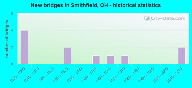
- New bridges - historical statistics
- 41900-1909
- 21930-1939
- 11950-1959
- 11960-1969
- 11970-1979
- 22010-2019

- Reconstructed bridges - Historical Statistics
- 11980-1989
- 31990-1999
- 12000-2009

- Bridge Condition - Deck
- 22.2%Excellent
- 66.7%Good
- 11.1%Satisfactory

- Bridge Condition - Superstructure
- 18.2%Excellent
- 18.2%Good
- 45.5%Satisfactory
- 9.1%Fair
- 9.1%Poor

- Bridge Condition - Substructure
- 18.2%Excellent
- 18.2%Good
- 36.4%Satisfactory
- 18.2%Fair
- 9.1%Poor

- Bridge Condition - Channel
- 18.2%Excellent
- 9.1%Good
- 54.5%Satisfactory
- 9.1%Fair
- 9.1%Poor
Find on map >> Show street view
Structure Number: 4102703, Location: 1.66 MI S OF SR 151 (Lat: 40.256011, Lng: -80.795750), Route carried "on" structure: State highway 152, Year Built: 1964, Status: Open, Structure Length: 0.73m (2.40ft), Average Daily Traffic: 2,291 (year 2015), Truck Traffic: 7%, Average Future Daily Traffic: 3,180 (year 2035), Design Load: H 15, Features Intersected: DRY CREEK
Minimum Vertical Clearance: 30+ m (98+ ft), Kilometerpoint: 7.178, Lanes on structure: 2, Owner: State Highway Agency, Approaching Roadway Width: 7.3m (24.0ft), Skew: 3 degrees, Material/Design: Concrete, Design/Construction: Slab, Number Of Spans In Main Unit: 1, Length of Maximum Span: 7.0m (23.0ft), Curb-To-Curb Width: 12.2m (40.0ft), Out-to-Out Width: 12.2m (40.0ft)
Condition: Deck: Satisfactory, Superstructure: Satisfactory, Substructure: Fair, Channel: Satisfactory, Operating Rating: 42.1 metric tons, Method Used To Determine Operating Rating: Load Factor (LF) rating reported by rating factor (RF) method using MS18 loading, Inventory Rating: 32.4 metric tons, Method Used To Determine Inventory Rating: Load Factor (LF) rating reported by rating factor (RF) method using MS18 loading, Structural Evaluation: Somewhat better than minimum adequacy, Deck Geometry: Equal to present minimum criteria, Waterway Adequacy: Equal to present desirable criteria, Approach Roadway Alignment: Equal to present desirable criteria, Designated Inspection Frequency: Every 12 months, Inspection Date: October 2021, Deck Structure Type: Concrete Cast-file-Place, Wearing Surface/Protective System: Wearing Surface: Bituminous
Find on map >> Show street view
Structure Number: 4130499, Location: 1.7 miles S CR10 (Lat: 40.252339, Lng: -80.822489), Route carried "on" structure: County highway C0011, Year Built: 1900, Year Reconstructed: 1980, Status: Open, Structure Length: 1.68m (5.51ft), Average Daily Traffic: 797 (year 2015), Truck Traffic: 8%, Average Future Daily Traffic: 1,106 (year 2035), Design Load: HS 20, Features Intersected: PINEY FORK, Facility Carried by Structure: Jeff CR11
Minimum Vertical Clearance: 30+ m (98+ ft), Kilometerpoint: 3.621, Lanes on structure: 2, Owner: County Highway Agency, Approaching Roadway Width: 8.2m (26.9ft), Skew: 2 degrees, Material/Design: Steel, Design/Construction: Stringer/Multi-beam, Number Of Spans In Main Unit: 1, Length of Maximum Span: 16.2m (53.1ft), Curb-To-Curb Width: 7.2m (23.6ft), Out-to-Out Width: 7.6m (24.9ft)
Condition: Deck: Good, Superstructure: Fair, Substructure: Fair, Channel: Satisfactory, Operating Rating: 42.1 metric tons, Method Used To Determine Operating Rating: Allowable Stress (AS) rating reported by rating factor (RF) method using MS18 loading, Inventory Rating: 32.4 metric tons, Method Used To Determine Inventory Rating: Allowable Stress (AS) rating reported by rating factor (RF) method using MS18 loading, Structural Evaluation: Somewhat better than minimum adequacy, Deck Geometry: Meets minimum limits, Waterway Adequacy: High priority of corrective action, Approach Roadway Alignment: Somewhat better than minimum adequacy, Designated Inspection Frequency: Every 12 months, Inspection Date: May 2021, Deck Structure Type: Concrete Cast-file-Place, Wearing Surface/Protective System: Wearing Surface: Bituminous
Find on map >> Show street view
Structure Number: 4130502, Location: 2.39MI N-W OF SR152 (Lat: 40.253689, Lng: -80.823731), Route carried "on" structure: County highway C0011, Year Built: 1901, Year Reconstructed: 1997, Status: Posted for load, Structure Length: 1.62m (5.31ft), Average Daily Traffic: 477 (year 2015), Truck Traffic: 8%, Average Future Daily Traffic: 662 (year 2035), Design Load: HL 93, Features Intersected: MC INTYRE CREEK, Facility Carried by Structure: CR11 PINEY FORK RD
Minimum Vertical Clearance: 30+ m (98+ ft), Kilometerpoint: 3.846, Lanes on structure: 2, Owner: County Highway Agency, Approaching Roadway Width: 9.1m (29.9ft), Skew: 2 degrees, Material/Design: Steel, Design/Construction: Stringer/Multi-beam, Number Of Spans In Main Unit: 1, Length of Maximum Span: 15.2m (49.9ft), Curb-To-Curb Width: 7.3m (24.0ft), Out-to-Out Width: 7.3m (24.0ft)
Condition: Deck: Good, Superstructure: Satisfactory, Substructure: Satisfactory, Channel: Satisfactory, Operating Rating: 19.4 metric tons, Method Used To Determine Operating Rating: Load and Resistance Factor Rating (LRFR) rating reported by rating factor(RF) method using HL-93 loadings, Inventory Rating: 16.2 metric tons, Method Used To Determine Inventory Rating: Load and Resistance Factor Rating (LRFR) rating reported by rating factor(RF) method using HL-93 loadings, Structural Evaluation: Somewhat better than minimum adequacy, Deck Geometry: Meets minimum limits, Waterway Adequacy: Better than present minimum criteria, Approach Roadway Alignment: Equal to present desirable criteria, Bridge Posting: Required (Relationship of Operating Rating to Maximum Legal Load: > 39.9% below), Designated Inspection Frequency: Every 12 months, Inspection Date: May 2021, Deck Structure Type: Corrugated Steel, Wearing Surface/Protective System: Wearing Surface: Bituminous
Find on map >> Show street view
Structure Number: 4130651, Location: 0.7 Mi NE of SR151 (Lat: 40.288000, Lng: -80.753400), Route carried "on" structure: County highway C0025, Year Built: 2018, Status: Open, Structure Length: 1.13m (3.71ft), Average Daily Traffic: 80 (year 2016), Truck Traffic: 8%, Average Future Daily Traffic: 71 (year 2036), Design Load: HL 93, Features Intersected: McIntyre Creek, Facility Carried by Structure: CR25
Minimum Vertical Clearance: 30+ m (98+ ft), Kilometerpoint: 1.094, Lanes on structure: 2, Owner: County Highway Agency, Approaching Roadway Width: 6.1m (20.0ft), Skew: 4 degrees, Material/Design: Concrete, Design/Construction: Frame, Number Of Spans In Main Unit: 1, Length of Maximum Span: 10.4m (34.1ft), Curb-To-Curb Width: 6.1m (20.0ft), Out-to-Out Width: 21.9m (71.9ft)
Condition: Deck: Excellent, Superstructure: Excellent, Substructure: Excellent, Channel: Excellent, Operating Rating: 51.8 metric tons, Method Used To Determine Operating Rating: Assigned ratings based on Load and Resistance Factor Design (LRFD) reported by rating factor (RF) using HL93 loadings, Inventory Rating: 38.9 metric tons, Method Used To Determine Inventory Rating: Assigned ratings based on Load and Resistance Factor Design (LRFD) reported by rating factor (RF) using HL93 loadings, Structural Evaluation: Superior to present desirable criteria, Deck Geometry: Somewhat better than minimum adequacy, Waterway Adequacy: Superior to present desirable criteria, Approach Roadway Alignment: Equal to present minimum criteria, Length Of Structure Improvement: 2.19m (7.19ft), Designated Inspection Frequency: Every 24 months, Inspection Date: May 2021, Bridge Improvement Cost: $260,000,000, Total Project Cost: $260,000,000, Deck Structure Type: Concrete Cast-file-Place, Wearing Surface/Protective System: Wearing Surface: Bituminous, Deck Protection: Epoxy Coated Reinforcing
Find on map >> Show street view
Structure Number: 4131607, Location: 2.55-Mi NW of SR150 (Lat: 40.238381, Lng: -80.786561), Route carried "on" structure: County highway CR008, Year Built: 2018, Status: Open, Structure Length: 1.19m (3.90ft), Average Daily Traffic: 473 (year 2015), Truck Traffic: 8%, Average Future Daily Traffic: 657 (year 2035), Design Load: HL 93, Features Intersected: Dry Fork, Facility Carried by Structure: CR8
Minimum Vertical Clearance: 30+ m (98+ ft), Kilometerpoint: 4.104, Lanes on structure: 2, Owner: County Highway Agency, Approaching Roadway Width: 6.1m (20.0ft), Skew: 5 degrees, Material/Design: Concrete, Design/Construction: Frame, Number Of Spans In Main Unit: 1, Length of Maximum Span: 10.7m (35.1ft), Curb-To-Curb Width: 7.3m (24.0ft), Out-to-Out Width: 26.8m (87.9ft)
Condition: Deck: Excellent, Superstructure: Excellent, Substructure: Excellent, Channel: Excellent, Operating Rating: 42.1 metric tons, Method Used To Determine Operating Rating: Assigned ratings based on Load and Resistance Factor Design (LRFD) reported by rating factor (RF) using HL93 loadings, Inventory Rating: 32.4 metric tons, Method Used To Determine Inventory Rating: Assigned ratings based on Load and Resistance Factor Design (LRFD) reported by rating factor (RF) using HL93 loadings, Structural Evaluation: Equal to present desirable criteria, Deck Geometry: Meets minimum limits, Waterway Adequacy: Superior to present desirable criteria, Approach Roadway Alignment: Equal to present minimum criteria, Length Of Structure Improvement: 2.68m (8.79ft), Designated Inspection Frequency: Every 24 months, Inspection Date: April 2021, Bridge Improvement Cost: $192,416,000, Total Project Cost: $192,416,000, Deck Structure Type: Concrete Cast-file-Place, Wearing Surface/Protective System: Wearing Surface: Bituminous, Membrane: Other, Deck Protection: Epoxy Coated Reinforcing
Find on map >> Show street view
Structure Number: 4131614, Location: 2.7 miles N of SR150 (Lat: 40.240689, Lng: -80.789389), Route carried "on" structure: County highway C0008, Year Built: 1935, Status: Open, Structure Length: 1.13m (3.71ft), Average Daily Traffic: 473 (year 2015), Truck Traffic: 8%, Average Future Daily Traffic: 657 (year 2035), Features Intersected: DRY FORK, Facility Carried by Structure: Jeff CR8
Minimum Vertical Clearance: 30+ m (98+ ft), Kilometerpoint: 4.474, Lanes on structure: 2, Owner: County Highway Agency, Approaching Roadway Width: 6.1m (20.0ft), Skew: 4 degrees, Material/Design: Concrete, Design/Construction: Arch - Deck, Number Of Spans In Main Unit: 2, Length of Maximum Span: 5.2m (17.1ft), Curb-To-Curb Width: 9.8m (32.2ft), Out-to-Out Width: 10.5m (34.4ft)
Condition: Superstructure: Satisfactory, Substructure: Satisfactory, Channel: Poor, Operating Rating: 40.8 metric tons, Method Used To Determine Operating Rating: Field evaluation and documented engineering judgment, Inventory Rating: 32.7 metric tons, Method Used To Determine Inventory Rating: Field evaluation and documented engineering judgment, Structural Evaluation: Equal to present minimum criteria, Deck Geometry: Equal to present minimum criteria, Waterway Adequacy: Equal to present minimum criteria, Approach Roadway Alignment: Equal to present minimum criteria, Designated Inspection Frequency: Every 12 months, Inspection Date: April 2021, Deck Structure Type: Corrugated Steel, Wearing Surface/Protective System: Wearing Surface: Bituminous
Find on map >> Show street view
Structure Number: 4131622, Location: 0.3 Mi S SR152 (Lat: 40.247639, Lng: -80.793419), Route carried "on" structure: County highway C0008, Year Built: 1934, Status: Open, Structure Length: 0.67m (2.20ft), Average Daily Traffic: 473 (year 2015), Truck Traffic: 8%, Average Future Daily Traffic: 657 (year 2035), Features Intersected: DRY FORK, Facility Carried by Structure: NO DATA
Minimum Vertical Clearance: 30+ m (98+ ft), Kilometerpoint: 5.391, Lanes on structure: 2, Owner: County Highway Agency, Approaching Roadway Width: 6.1m (20.0ft), Material/Design: Concrete, Design/Construction: Arch - Deck, Number Of Spans In Main Unit: 1, Length of Maximum Span: 4.9m (16.1ft), Curb-To-Curb Width: 6.1m (20.0ft), Out-to-Out Width: 8.2m (26.9ft)
Condition: Superstructure: Satisfactory, Substructure: Satisfactory, Channel: Satisfactory, Operating Rating: 40.8 metric tons, Method Used To Determine Operating Rating: Field evaluation and documented engineering judgment, Inventory Rating: 32.7 metric tons, Method Used To Determine Inventory Rating: Field evaluation and documented engineering judgment, Structural Evaluation: Equal to present minimum criteria, Deck Geometry: High priority of corrective action, Waterway Adequacy: High priority of corrective action, Approach Roadway Alignment: Equal to present minimum criteria, Designated Inspection Frequency: Every 12 months, Inspection Date: April 2021, Deck Structure Type: Concrete Cast-file-Place, Wearing Surface/Protective System: Wearing Surface: Bituminous
Find on map >> Show street view
Structure Number: 4131657, Location: 200-Ft W CR11 (Lat: 40.260169, Lng: -80.836939), Route carried "on" structure: County highway T0134, Year Built: 1900, Year Reconstructed: 1997, Status: Posted for load, Structure Length: 1.49m (4.89ft), Average Daily Traffic: 10 (year 2015), Truck Traffic: 20%, Average Future Daily Traffic: 14 (year 2035), Design Load: HL 93, Features Intersected: PINEY FORK, Facility Carried by Structure: Smithfield T134
Minimum Vertical Clearance: 30+ m (98+ ft), Kilometerpoint: 0.644, Lanes on structure: 1, Owner: County Highway Agency, Approaching Roadway Width: 6.7m (22.0ft), Material/Design: Steel, Design/Construction: Stringer/Multi-beam, Number Of Spans In Main Unit: 1, Length of Maximum Span: 14.3m (46.9ft), Curb-To-Curb Width: 5.3m (17.4ft), Out-to-Out Width: 6.1m (20.0ft)
Condition: Deck: Good, Superstructure: Poor, Substructure: Poor, Channel: Satisfactory, Operating Rating: 29.2 metric tons, Method Used To Determine Operating Rating: Load and Resistance Factor Rating (LRFR) rating reported by rating factor(RF) method using HL-93 loadings, Inventory Rating: 22.7 metric tons, Method Used To Determine Inventory Rating: Load and Resistance Factor Rating (LRFR) rating reported by rating factor(RF) method using HL-93 loadings, Structural Evaluation: Meets minimum limits, Deck Geometry: High priority of corrective action, Waterway Adequacy: Better than present minimum criteria, Approach Roadway Alignment: Somewhat better than minimum adequacy, Bridge Posting: Required (Relationship of Operating Rating to Maximum Legal Load: 10.0 - 19.9% below), Designated Inspection Frequency: Every 12 months, Inspection Date: May 2021, Deck Structure Type: Corrugated Steel, Wearing Surface/Protective System: Wearing Surface: Bituminous
Find on map >> Show street view
Structure Number: 413244, Location: 0.3 Mi E CR23 (Lat: 40.304189, Lng: -80.800281), Route carried "on" structure: County highway T0177, Year Built: 1950, Status: Posted for load, Structure Length: 1.22m (4.00ft), Average Daily Traffic: 209 (year 2015), Truck Traffic: 7%, Average Future Daily Traffic: 290 (year 2035), Design Load: HL 93, Features Intersected: MCINTYRE CREEK, Facility Carried by Structure: Wayne Twp Rd 177
Minimum Vertical Clearance: 30+ m (98+ ft), Kilometerpoint: 0.644, Lanes on structure: 1, Owner: County Highway Agency, Approaching Roadway Width: 6.4m (21.0ft), Skew: 3 degrees, Material/Design: Steel, Design/Construction: Stringer/Multi-beam, Number Of Spans In Main Unit: 1, Length of Maximum Span: 11.3m (37.1ft), Curb-To-Curb Width: 5.3m (17.4ft), Out-to-Out Width: 5.9m (19.4ft)
Condition: Deck: Good, Superstructure: Satisfactory, Substructure: Satisfactory, Channel: Fair, Operating Rating: 35.6 metric tons, Method Used To Determine Operating Rating: Load and Resistance Factor Rating (LRFR) rating reported by rating factor(RF) method using HL-93 loadings, Inventory Rating: 22.7 metric tons, Method Used To Determine Inventory Rating: Load and Resistance Factor Rating (LRFR) rating reported by rating factor(RF) method using HL-93 loadings, Structural Evaluation: Equal to present minimum criteria, Deck Geometry: High priority of replacement, Waterway Adequacy: Better than present minimum criteria, Approach Roadway Alignment: Equal to present minimum criteria, Bridge Posting: Required (Relationship of Operating Rating to Maximum Legal Load: 20.0 - 29.9% below), Designated Inspection Frequency: Every 12 months, Inspection Date: May 2021, Deck Structure Type: Corrugated Steel, Wearing Surface/Protective System: Wearing Surface: Bituminous
Find on map >> Show street view
Structure Number: 4132505, Location: 0.05 MI E. JCT CR18 (Lat: 40.251669, Lng: -80.726669), Route carried "on" structure: County highway C0017, Year Built: 1900, Year Reconstructed: 1997, Status: Open, Structure Length: 0.76m (2.49ft), Average Daily Traffic: 81 (year 2015), Truck Traffic: 9%, Average Future Daily Traffic: 112 (year 2035), Design Load: HS 20, Features Intersected: RUSH RUN, Facility Carried by Structure: RUSH RUN RD CR17
Minimum Vertical Clearance: 30+ m (98+ ft), Kilometerpoint: 2.865, Lanes on structure: 2, Owner: County Highway Agency, Approaching Roadway Width: 9.1m (29.9ft), Skew: 4 degrees, Material/Design: Concrete, Design/Construction: Frame, Number Of Spans In Main Unit: 1, Length of Maximum Span: 7.0m (23.0ft), Curb-To-Curb Width: 7.3m (24.0ft), Out-to-Out Width: 9.1m (29.9ft)
Condition: Deck: Good, Superstructure: Good, Substructure: Good, Channel: Good, Operating Rating: 42.1 metric tons, Method Used To Determine Operating Rating: Load Factor (LF) rating reported by rating factor (RF) method using MS18 loading, Inventory Rating: 32.4 metric tons, Method Used To Determine Inventory Rating: Load Factor (LF) rating reported by rating factor (RF) method using MS18 loading, Structural Evaluation: Better than present minimum criteria, Deck Geometry: Equal to present minimum criteria, Waterway Adequacy: Better than present minimum criteria, Approach Roadway Alignment: Equal to present desirable criteria, Designated Inspection Frequency: Every 24 months, Inspection Date: June 2021, Deck Structure Type: Concrete Cast-file-Place, Wearing Surface/Protective System: Wearing Surface: Bituminous
Find on map >> Show street view
Structure Number: 4133951, Location: 0.08MIS OF SR152 (Lat: 40.233331, Lng: -80.783331), Route carried "on" structure: County highway T1195, Year Built: 1970, Year Reconstructed: 2006, Status: Open, Structure Length: 1.55m (5.09ft), Average Daily Traffic: 473 (year 2015), Truck Traffic: 8%, Average Future Daily Traffic: 657 (year 2035), Design Load: HL 93, Features Intersected: JOLLY ST. & PINEY FORK, Facility Carried by Structure: TR1195 JOLLY ST
Minimum Vertical Clearance: 30+ m (98+ ft), Kilometerpoint: 0.129, Lanes on structure: 1, Owner: County Highway Agency, Approaching Roadway Width: 5.5m (18.0ft), Material/Design: Concrete, Design/Construction: Box Beam or Girders - Multiple, Number Of Spans In Main Unit: 1, Length of Maximum Span: 14.6m (47.9ft), Curb-To-Curb Width: 4.6m (15.1ft), Out-to-Out Width: 4.6m (15.1ft)
Condition: Deck: Good, Superstructure: Good, Substructure: Good, Channel: Satisfactory, Operating Rating: 97.2 metric tons, Method Used To Determine Operating Rating: Load and Resistance Factor Rating (LRFR) rating reported by rating factor(RF) method using HL-93 loadings, Inventory Rating: 74.5 metric tons, Method Used To Determine Inventory Rating: Load and Resistance Factor Rating (LRFR) rating reported by rating factor(RF) method using HL-93 loadings, Structural Evaluation: Better than present minimum criteria, Deck Geometry: High priority of replacement, Waterway Adequacy: Better than present minimum criteria, Approach Roadway Alignment: Equal to present minimum criteria, Designated Inspection Frequency: Every 24 months, Inspection Date: April 2021, Deck Structure Type: Concrete Cast-file-Place, Wearing Surface/Protective System: Wearing Surface: Bituminous