Bridge Statistics for Skyline View, Pennsylvania (PA)
Condition, Traffic, Stress, Structural Evaluation, Project Costs
- National Bridge Inventory (NBI) Statistics
- 37Number of bridges
- 240ft / 72.8mTotal length
- $2,285,000Total costs
- 479,407Total average daily traffic
- 154,782Total average daily truck traffic
- National Bridge Inventory (NBI) Registered Bridges for Skyline View
- No street view available for this location
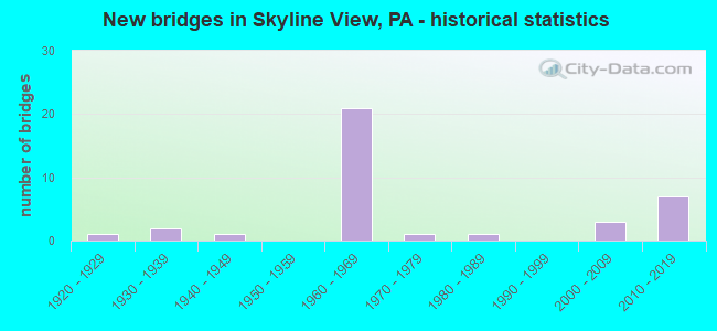
- New bridges - historical statistics
- 11920-1929
- 21930-1939
- 11940-1949
- 211960-1969
- 11970-1979
- 11980-1989
- 32000-2009
- 72010-2019

- Reconstructed bridges - Historical Statistics
- 21980-1989
- 61990-1999
- 02000-2009
- 12010-2019


- Bridge Condition - Deck
- 15.0%Very good
- 75.0%Good
- 5.0%Satisfactory
- 5.0%Fair

- Bridge Condition - Superstructure
- 20.0%Very good
- 50.0%Good
- 20.0%Satisfactory
- 5.0%Fair
- 5.0%Poor

- Bridge Condition - Substructure
- 25.0%Very good
- 20.0%Good
- 40.0%Satisfactory
- 10.0%Fair
- 5.0%Poor

- Bridge Condition - Channel
- 5.6%Very good
- 27.8%Good
- 16.7%Satisfactory
- 38.9%Fair
- 11.1%Poor

- Bridge Condition - Culverts
- 33.3%Good
- 50.0%Satisfactory
- 16.7%Fair
Find on map >> Show street view
Structure Number: 426, Location: 1 NE ABBOTTSTOWN/PINE RUN (Lat: 39.891850, Lng: -77.015972), Route carried "on" structure: City street , Year Built: 1986, Status: Open, Structure Length: 0.67m (2.20ft), Average Daily Traffic: 150 (year 2009), Truck Traffic: 3%, Average Future Daily Traffic: 70 (year 2030), Features Intersected: PINE RUN, Facility Carried by Structure: WOODS ROAD
Minimum Vertical Clearance: 30+ m (98+ ft), Kilometerpoint: 0.000, Lanes on structure: 2, Owner: Town or Township Highway Agency, Approaching Roadway Width: 5.8m (19.0ft), Skew: 1 degrees, Material/Design: Concrete, Design/Construction: Culvert, Number Of Spans In Main Unit: 2, Length of Maximum Span: 3.0m (9.8ft), Curb-To-Curb Width: 5.8m (19.0ft), Out-to-Out Width: 8.8m (28.9ft)
Condition: Channel: Poor, Culverts: Good, Operating Rating: 53.5 metric tons, Method Used To Determine Operating Rating: Field evaluation and documented engineering judgment, Inventory Rating: 31.8 metric tons, Method Used To Determine Inventory Rating: Field evaluation and documented engineering judgment, Structural Evaluation: Better than present minimum criteria, Deck Geometry: High priority of corrective action, Waterway Adequacy: Better than present minimum criteria, Approach Roadway Alignment: Equal to present desirable criteria, Length Of Structure Improvement: 1.40m (4.59ft), Designated Inspection Frequency: Every 24 months, Inspection Date: August 2021, Wearing Surface/Protective System: Wearing Surface: Bituminous
Find on map >> Show street view
Structure Number: 593, Location: 3 MI.W.OF SPROUL (Lat: 40.281867, Lng: -78.491817), Route carried "on" structure: City street , Year Built: 1920, Year Reconstructed: 2010, Status: Posted for load, Structure Length: 0.82m (2.69ft), Average Daily Traffic: 46 (year 2021), Average Future Daily Traffic: 58 (year 2041), Design Load: HL 93, Features Intersected: SMOKY RUN, Facility Carried by Structure: T-525,HELSEL ROAD
Minimum Vertical Clearance: 30+ m (98+ ft), Kilometerpoint: 0.000, Lanes on structure: 2, Owner: Town or Township Highway Agency, Approaching Roadway Width: 3.7m (12.1ft), Material/Design: Steel, Design/Construction: Stringer/Multi-beam, Number Of Spans In Main Unit: 1, Length of Maximum Span: 7.9m (25.9ft), Curb-To-Curb Width: 6.7m (22.0ft), Out-to-Out Width: 6.9m (22.6ft)
Condition: Deck: Fair, Superstructure: Satisfactory, Substructure: Poor, Channel: Poor, Operating Rating: 28.1 metric tons, Method Used To Determine Operating Rating: Load Factor (LF), Inventory Rating: 16.3 metric tons, Method Used To Determine Inventory Rating: Load Factor (LF), Structural Evaluation: Meets minimum limits, Deck Geometry: Somewhat better than minimum adequacy, Waterway Adequacy: Better than present minimum criteria, Approach Roadway Alignment: Equal to present desirable criteria, Bridge Posting: Required (Relationship of Operating Rating to Maximum Legal Load: > 39.9% below), Length Of Structure Improvement: 1.10m (3.61ft), Designated Inspection Frequency: Every 24 months, Other Special Inspection Frequency: Every 12 months, Inspection Date: October 2020, Other Special Inspection Date: October 2021, Bridge Improvement Cost: $42,000, Roadway Improvement Cost: $233,000, Total Project Cost: $561,000, Deck Structure Type: Wood or Timber, Wearing Surface/Protective System: Wearing Surface: Wood or Timber
Find on map >> Show street view
Structure Number: 9046, Location: LEONARDSVILLE (Lat: 41.078417, Lng: -75.690903), Route carried "on" structure: State highway 940, Year Built: 1934, Year Reconstructed: 1997, Status: Open, Structure Length: 0.70m (2.30ft), Average Daily Traffic: 2,212 (year 2022), Truck Traffic: 9%, Average Future Daily Traffic: 3,472 (year 2032), Design Load: HS 25 or greater, Features Intersected: HAYES CREEK
Minimum Vertical Clearance: 30+ m (98+ ft), Kilometerpoint: 7.514, Lanes on structure: 2, Base Highway Network: Yes, Owner: State Highway Agency, Approaching Roadway Width: 11.0m (36.1ft), Skew: 3 degrees, Material/Design: Concrete, Design/Construction: Slab, Number Of Spans In Main Unit: 1, Length of Maximum Span: 6.4m (21.0ft), Curb-To-Curb Width: 11.0m (36.1ft), Out-to-Out Width: 12.2m (40.0ft)
Condition: Deck: Good, Superstructure: Good, Substructure: Good, Channel: Satisfactory, Operating Rating: 47.2 metric tons, Method Used To Determine Operating Rating: Load Factor (LF), Inventory Rating: 28.1 metric tons, Method Used To Determine Inventory Rating: Load Factor (LF), Structural Evaluation: Better than present minimum criteria, Deck Geometry: Somewhat better than minimum adequacy, Waterway Adequacy: Equal to present minimum criteria, Approach Roadway Alignment: Equal to present desirable criteria, Length Of Structure Improvement: 1.30m (4.27ft), Designated Inspection Frequency: Every 24 months, Inspection Date: September 2021, Wearing Surface/Protective System: Wearing Surface: Bituminous
Find on map >> Show street view
Structure Number: 14186, Location: 1 MI S MANADA (Lat: 40.349578, Lng: -76.686150), Route carried "on" structure: US 22, Year Built: 1944, Status: Open, Structure Length: 0.70m (2.30ft), Average Daily Traffic: 7,826 (year 2020), Truck Traffic: 6%, Average Future Daily Traffic: 15,242 (year 2032), Design Load: HS 20, Features Intersected: TRIB.MANADA CREEK
Minimum Vertical Clearance: 30+ m (98+ ft), Kilometerpoint: 42.817, Lanes on structure: 4, Owner: State Highway Agency, Approaching Roadway Width: 20.1m (65.9ft), Skew: 23 degrees, Material/Design: Concrete, Design/Construction: Culvert, Number Of Spans In Main Unit: 1, Length of Maximum Span: 7.0m (23.0ft)
Condition: Channel: Satisfactory, Culverts: Satisfactory, Operating Rating: 69.9 metric tons, Method Used To Determine Operating Rating: Allowable Stress (AS), Inventory Rating: 46.3 metric tons, Method Used To Determine Inventory Rating: Allowable Stress (AS), Structural Evaluation: Equal to present minimum criteria, Waterway Adequacy: Superior to present desirable criteria, Approach Roadway Alignment: Equal to present desirable criteria, Length Of Structure Improvement: 1.30m (4.27ft), Designated Inspection Frequency: Every 24 months, Inspection Date: September 2020
Find on map >> Show street view
Structure Number: 14206, Location: 3MI E OF LINGLESTOWN (Lat: 40.352653, Lng: -76.721117), Route carried "on" structure: State highway 39, Year Built: 1967, Status: Open, Structure Length: 11.13m (36.52ft), Average Daily Traffic: 5,998 (year 2020), Truck Traffic: 9%, Average Future Daily Traffic: 14,258 (year 2032), Design Load: HS 20, Features Intersected: I-81; SR 0081
Minimum Vertical Clearance: 30+ m (98+ ft), Kilometerpoint: 15.463, Lanes on structure: 4, Lanes under structure: 8, Owner: State Highway Agency, Approaching Roadway Width: 20.1m (65.9ft), Skew: 24 degrees, Material/Design: Prestressed concrete, Design/Construction: Stringer/Multi-beam, Number Of Spans In Main Unit: 5, Length of Maximum Span: 25.9m (85.0ft), Curb or Sidewalk Widths: Left: 0.2m (0.7ft), Right: 0.2m (0.7ft), Curb-To-Curb Width: 22.4m (73.5ft), Out-to-Out Width: 23.6m (77.4ft)
Condition: Deck: Good, Superstructure: Good, Substructure: Satisfactory, Operating Rating: 70.8 metric tons, Method Used To Determine Operating Rating: Load Factor (LF), Inventory Rating: 16.3 metric tons, Method Used To Determine Inventory Rating: Load Factor (LF), Structural Evaluation: Meets minimum limits, Deck Geometry: Superior to present desirable criteria, Underclear: Somewhat better than minimum adequacy, Approach Roadway Alignment: Equal to present desirable criteria, Length Of Structure Improvement: 12.20m (40.03ft), Designated Inspection Frequency: Every 24 months, Inspection Date: October 2020, Bridge Improvement Cost: $68,000, Roadway Improvement Cost: $200,000, Total Project Cost: $916,000, Deck Structure Type: Concrete Cast-file-Place, Wearing Surface/Protective System: Wearing Surface: Latex Concrete
Find on map >> Show street view
Structure Number: 14239, Location: 1 MI. S.E. LINGLESTOWN (Lat: 40.333103, Lng: -76.757372), Route carried "on" structure: Interstate 81, Year Built: 1969, Year Reconstructed: 1995, Status: Open, Structure Length: 3.57m (11.71ft), Average Daily Traffic: 31,317 (year 2021), Truck Traffic: 34%, Average Future Daily Traffic: 39,197 (year 2032), Design Load: HS 25 or greater, Features Intersected: T-561 Blue Ridge Ave.
Minimum Vertical Clearance: 30+ m (98+ ft), Kilometerpoint: 14.808, Lanes on structure: 2, Lanes under structure: 2, Base Highway Network: Yes, Owner: State Highway Agency, Approaching Roadway Width: 15.8m (51.8ft), Skew: 10 degrees, Material/Design: Prestressed concrete continuous, Design/Construction: Box Beam or Girders - Single/Spread, Number Of Spans In Main Unit: 3, Length of Maximum Span: 15.5m (50.9ft), Curb or Sidewalk Widths: Left: 0.2m (0.7ft), Right: 0.2m (0.7ft), Curb-To-Curb Width: 15.8m (51.8ft), Out-to-Out Width: 16.9m (55.4ft)
Condition: Deck: Good, Superstructure: Good, Substructure: Good, Operating Rating: 73.5 metric tons, Method Used To Determine Operating Rating: Load Factor (LF), Inventory Rating: 43.5 metric tons, Method Used To Determine Inventory Rating: Load Factor (LF), Structural Evaluation: Better than present minimum criteria, Deck Geometry: Superior to present desirable criteria, Underclear: Somewhat better than minimum adequacy, Approach Roadway Alignment: Equal to present desirable criteria, Length Of Structure Improvement: 4.50m (14.76ft), Designated Inspection Frequency: Every 24 months, Inspection Date: November 2020, Deck Structure Type: Concrete Cast-file-Place, Wearing Surface/Protective System: Wearing Surface: Monolithic Concrete, Deck Protection: Epoxy Coated Reinforcing
Find on map >> Show street view
Structure Number: 14242, Location: 2 MI. E. LINGLESTOWN (Lat: 40.345297, Lng: -76.741106), Route carried "on" structure: Interstate 81, Year Built: 1969, Year Reconstructed: 1995, Status: Open, Structure Length: 4.11m (13.48ft), Average Daily Traffic: 31,317 (year 2021), Truck Traffic: 34%, Average Future Daily Traffic: 39,197 (year 2032), Design Load: HS 25 or greater, Features Intersected: TWP RD 465
Minimum Vertical Clearance: 30+ m (98+ ft), Kilometerpoint: 16.415, Lanes on structure: 2, Lanes under structure: 2, Base Highway Network: Yes, Owner: State Highway Agency, Approaching Roadway Width: 15.8m (51.8ft), Skew: 14 degrees, Material/Design: Prestressed concrete, Design/Construction: Box Beam or Girders - Single/Spread, Number Of Spans In Main Unit: 3, Length of Maximum Span: 16.2m (53.1ft), Curb or Sidewalk Widths: Left: 0.2m (0.7ft), Right: 0.2m (0.7ft), Curb-To-Curb Width: 15.8m (51.8ft), Out-to-Out Width: 16.9m (55.4ft)
Condition: Deck: Good, Superstructure: Good, Substructure: Satisfactory, Operating Rating: 80.7 metric tons, Method Used To Determine Operating Rating: Load Factor (LF), Inventory Rating: 49.0 metric tons, Method Used To Determine Inventory Rating: Load Factor (LF), Structural Evaluation: Equal to present minimum criteria, Deck Geometry: Superior to present desirable criteria, Underclear: Meets minimum limits, Approach Roadway Alignment: Equal to present desirable criteria, Length Of Structure Improvement: 5.10m (16.73ft), Designated Inspection Frequency: Every 24 months, Inspection Date: September 2020, Deck Structure Type: Concrete Cast-file-Place, Wearing Surface/Protective System: Wearing Surface: Monolithic Concrete, Deck Protection: Epoxy Coated Reinforcing
Find on map >> Show street view
Structure Number: 14243, Location: 2.5 MI. E. LINGLESTOWN (Lat: 40.345081, Lng: -76.742067), Route carried "on" structure: Interstate 81, Year Built: 1969, Year Reconstructed: 1995, Status: Open, Structure Length: 4.11m (13.48ft), Average Daily Traffic: 34,061 (year 2021), Truck Traffic: 27%, Average Future Daily Traffic: 39,770 (year 2032), Design Load: HS 25 or greater, Features Intersected: TWP RD 465
Minimum Vertical Clearance: 30+ m (98+ ft), Kilometerpoint: 16.320, Lanes on structure: 2, Lanes under structure: 2, Base Highway Network: Yes, Owner: State Highway Agency, Approaching Roadway Width: 15.2m (49.9ft), Skew: 14 degrees, Material/Design: Prestressed concrete, Design/Construction: Box Beam or Girders - Single/Spread, Number Of Spans In Main Unit: 3, Length of Maximum Span: 16.2m (53.1ft), Curb-To-Curb Width: 15.8m (51.8ft), Out-to-Out Width: 16.9m (55.4ft)
Condition: Deck: Good, Superstructure: Good, Substructure: Satisfactory, Operating Rating: 78.9 metric tons, Method Used To Determine Operating Rating: Load Factor (LF), Inventory Rating: 47.2 metric tons, Method Used To Determine Inventory Rating: Load Factor (LF), Structural Evaluation: Equal to present minimum criteria, Deck Geometry: Superior to present desirable criteria, Underclear: Meets minimum limits, Approach Roadway Alignment: Equal to present desirable criteria, Length Of Structure Improvement: 5.10m (16.73ft), Designated Inspection Frequency: Every 24 months, Inspection Date: September 2020, Deck Structure Type: Concrete Cast-file-Place, Wearing Surface/Protective System: Wearing Surface: Monolithic Concrete, Deck Protection: Epoxy Coated Reinforcing
Find on map >> Show street view
Structure Number: 14244, Location: 1 MI. W. OF MANADA (Lat: 40.353333, Lng: -76.730000), Route carried "on" structure: State highway , Year Built: 1967, Status: Open, Structure Length: 7.77m (25.49ft), Average Daily Traffic: 687 (year 2021), Truck Traffic: 3%, Average Future Daily Traffic: 1,192 (year 2032), Design Load: HS 20, Features Intersected: I-81; SR 0081, Facility Carried by Structure: T-526
Minimum Vertical Clearance: 30+ m (98+ ft), Kilometerpoint: 0.000, Lanes on structure: 2, Lanes under structure: 8, Owner: State Highway Agency, Approaching Roadway Width: 7.3m (24.0ft), Skew: 1 degrees, Material/Design: Prestressed concrete, Design/Construction: Box Beam or Girders - Single/Spread, Number Of Spans In Main Unit: 5, Length of Maximum Span: 18.0m (59.1ft), Curb or Sidewalk Widths: Left: 0.2m (0.7ft), Right: 0.2m (0.7ft), Curb-To-Curb Width: 9.0m (29.5ft), Out-to-Out Width: 10.2m (33.5ft)
Condition: Deck: Good, Superstructure: Satisfactory, Substructure: Fair, Operating Rating: 52.6 metric tons, Method Used To Determine Operating Rating: Load Factor (LF), Inventory Rating: 21.8 metric tons, Method Used To Determine Inventory Rating: Load Factor (LF), Structural Evaluation: Somewhat better than minimum adequacy, Deck Geometry: Somewhat better than minimum adequacy, Underclear: Better than present minimum criteria, Approach Roadway Alignment: Better than present minimum criteria, Length Of Structure Improvement: 8.80m (28.87ft), Designated Inspection Frequency: Every 24 months, Inspection Date: October 2020, Bridge Improvement Cost: $21,000, Roadway Improvement Cost: $62,000, Total Project Cost: $285,000, Deck Structure Type: Concrete Cast-file-Place, Wearing Surface/Protective System: Wearing Surface: Latex Concrete
Find on map >> Show street view
Structure Number: 14245, Location: Shellsville (Lat: 40.358658, Lng: -76.711975), Route carried "on" structure: Interstate 81, Year Built: 1967, Status: Open, Structure Length: 0.67m (2.20ft), Average Daily Traffic: 59,871 (year 2020), Truck Traffic: 39%, Average Future Daily Traffic: 78,967 (year 2032), Design Load: HS 20, Features Intersected: Walnut Run
Minimum Vertical Clearance: 30+ m (98+ ft), Kilometerpoint: 19.615, Lanes on structure: 4, Base Highway Network: Yes, Owner: State Highway Agency, Approaching Roadway Width: 46.3m (151.9ft), Skew: 20 degrees, Material/Design: Concrete, Design/Construction: Culvert, Number Of Spans In Main Unit: 1, Length of Maximum Span: 6.7m (22.0ft)
Condition: Channel: Fair, Culverts: Satisfactory, Operating Rating: 69.9 metric tons, Method Used To Determine Operating Rating: Load Factor (LF), Inventory Rating: 46.3 metric tons, Method Used To Determine Inventory Rating: Load Factor (LF), Structural Evaluation: Equal to present minimum criteria, Waterway Adequacy: Superior to present desirable criteria, Approach Roadway Alignment: Equal to present desirable criteria, Length Of Structure Improvement: 1.30m (4.27ft), Designated Inspection Frequency: Every 24 months, Inspection Date: October 2020
Find on map >> Show street view
Structure Number: 14246, Location: SHELLSVILLE (Lat: 40.361842, Lng: -76.707444), Route carried "on" structure: Interstate 81, Year Built: 1967, Year Reconstructed: 1995, Status: Open, Structure Length: 3.51m (11.52ft), Average Daily Traffic: 29,858 (year 2020), Truck Traffic: 41%, Average Future Daily Traffic: 39,197 (year 2032), Design Load: HS 20+Mod, Features Intersected: SR 2017
Minimum Vertical Clearance: 30+ m (98+ ft), Kilometerpoint: 20.419, Lanes on structure: 2, Lanes under structure: 2, Base Highway Network: Yes, Owner: State Highway Agency, Approaching Roadway Width: 15.8m (51.8ft), Skew: 12 degrees, Material/Design: Prestressed concrete continuous, Design/Construction: Box Beam or Girders - Single/Spread, Number Of Spans In Main Unit: 3, Length of Maximum Span: 13.1m (43.0ft), Curb or Sidewalk Widths: Left: 0.2m (0.7ft), Right: 0.2m (0.7ft), Curb-To-Curb Width: 15.8m (51.8ft), Out-to-Out Width: 16.9m (55.4ft)
Condition: Deck: Good, Superstructure: Good, Substructure: Satisfactory, Operating Rating: 65.3 metric tons, Method Used To Determine Operating Rating: Load Factor (LF), Inventory Rating: 39.0 metric tons, Method Used To Determine Inventory Rating: Load Factor (LF), Structural Evaluation: Equal to present minimum criteria, Deck Geometry: Superior to present desirable criteria, Underclear: Meets minimum limits, Approach Roadway Alignment: Equal to present desirable criteria, Length Of Structure Improvement: 4.40m (14.44ft), Designated Inspection Frequency: Every 24 months, Inspection Date: October 2020, Deck Structure Type: Concrete Cast-file-Place, Wearing Surface/Protective System: Wearing Surface: Monolithic Concrete, Deck Protection: Epoxy Coated Reinforcing
Find on map >> Show street view
Structure Number: 14247, Location: 1 MI. N.E. MANADA (Lat: 40.363217, Lng: -76.705389), Route carried "on" structure: Interstate 81, Year Built: 1967, Status: Open, Structure Length: 1.83m (6.00ft), Average Daily Traffic: 59,871 (year 2020), Truck Traffic: 39%, Average Future Daily Traffic: 78,967 (year 2032), Design Load: HS 20, Features Intersected: MANADA CREEK
Minimum Vertical Clearance: 30+ m (98+ ft), Kilometerpoint: 20.419, Lanes on structure: 4, Base Highway Network: Yes, Owner: State Highway Agency, Approaching Roadway Width: 49.7m (163.1ft), Skew: 21 degrees, Material/Design: Concrete, Design/Construction: Culvert, Number Of Spans In Main Unit: 1, Length of Maximum Span: 18.3m (60.0ft)
Condition: Channel: Good, Culverts: Satisfactory, Operating Rating: 62.6 metric tons, Method Used To Determine Operating Rating: Field evaluation and documented engineering judgment, Inventory Rating: 37.2 metric tons, Method Used To Determine Inventory Rating: Field evaluation and documented engineering judgment, Structural Evaluation: Equal to present minimum criteria, Waterway Adequacy: Superior to present desirable criteria, Approach Roadway Alignment: Equal to present desirable criteria, Length Of Structure Improvement: 2.50m (8.20ft), Designated Inspection Frequency: Every 24 months, Inspection Date: September 2020
Find on map >> Show street view
Structure Number: 1425, Location: 1 MI. E. SHELLSVILLE (Lat: 40.369753, Lng: -76.685700), Route carried "on" structure: Interstate 81, Year Built: 1967, Year Reconstructed: 1994, Status: Open, Structure Length: 3.05m (10.01ft), Average Daily Traffic: 29,858 (year 2020), Truck Traffic: 41%, Average Future Daily Traffic: 39,197 (year 2032), Design Load: HS 25 or greater, Features Intersected: SR 2015
Minimum Vertical Clearance: 30+ m (98+ ft), Kilometerpoint: 22.017, Lanes on structure: 2, Lanes under structure: 2, Base Highway Network: Yes, Owner: State Highway Agency, Approaching Roadway Width: 15.8m (51.8ft), Skew: 10 degrees, Material/Design: Prestressed concrete, Design/Construction: Box Beam or Girders - Single/Spread, Number Of Spans In Main Unit: 3, Length of Maximum Span: 10.7m (35.1ft), Curb or Sidewalk Widths: Left: 0.2m (0.7ft), Right: 0.2m (0.7ft), Curb-To-Curb Width: 15.8m (51.8ft), Out-to-Out Width: 16.9m (55.4ft)
Condition: Deck: Satisfactory, Superstructure: Satisfactory, Substructure: Satisfactory, Operating Rating: 75.3 metric tons, Method Used To Determine Operating Rating: Load Factor (LF), Inventory Rating: 43.5 metric tons, Method Used To Determine Inventory Rating: Load Factor (LF), Structural Evaluation: Equal to present minimum criteria, Deck Geometry: Superior to present desirable criteria, Underclear: Meets minimum limits, Approach Roadway Alignment: Equal to present desirable criteria, Length Of Structure Improvement: 3.80m (12.47ft), Designated Inspection Frequency: Every 24 months, Inspection Date: September 2020, Deck Structure Type: Concrete Cast-file-Place, Wearing Surface/Protective System: Wearing Surface: Monolithic Concrete, Deck Protection: Epoxy Coated Reinforcing
Find on map >> Show street view
Structure Number: 14251, Location: 1 MI.E. OF SHELLSVILLE (Lat: 40.369956, Lng: -76.686019), Route carried "on" structure: Interstate 81, Year Built: 1967, Year Reconstructed: 1995, Status: Open, Structure Length: 3.14m (10.30ft), Average Daily Traffic: 30,013 (year 2020), Truck Traffic: 38%, Average Future Daily Traffic: 39,770 (year 2032), Design Load: HS 25 or greater, Features Intersected: SR 2015 MANADA GAP RD
Minimum Vertical Clearance: 30+ m (98+ ft), Kilometerpoint: 21.942, Lanes on structure: 2, Lanes under structure: 2, Base Highway Network: Yes, Owner: State Highway Agency, Approaching Roadway Width: 15.2m (49.9ft), Skew: 10 degrees, Material/Design: Prestressed concrete, Design/Construction: Box Beam or Girders - Single/Spread, Number Of Spans In Main Unit: 3, Length of Maximum Span: 10.7m (35.1ft), Curb or Sidewalk Widths: Left: 0.2m (0.7ft), Right: 0.2m (0.7ft), Curb-To-Curb Width: 15.8m (51.8ft), Out-to-Out Width: 16.9m (55.4ft)
Condition: Deck: Good, Superstructure: Good, Substructure: Satisfactory, Operating Rating: 67.1 metric tons, Method Used To Determine Operating Rating: Load Factor (LF), Inventory Rating: 39.9 metric tons, Method Used To Determine Inventory Rating: Load Factor (LF), Structural Evaluation: Equal to present minimum criteria, Deck Geometry: Superior to present desirable criteria, Underclear: Meets minimum limits, Approach Roadway Alignment: Equal to present desirable criteria, Length Of Structure Improvement: 4.00m (13.12ft), Designated Inspection Frequency: Every 24 months, Inspection Date: September 2020, Deck Structure Type: Concrete Cast-file-Place, Wearing Surface/Protective System: Wearing Surface: Monolithic Concrete, Deck Protection: Epoxy Coated Reinforcing
Find on map >> Show street view
Structure Number: 14655, Location: 1E US 22 & PA 39/MANADA C (Lat: 40.346278, Lng: -76.695217), Route carried "on" structure: City street , Year Built: 1930, Year Reconstructed: 1994, Status: Posted for load, Structure Length: 0.79m (2.59ft), Average Daily Traffic: 50 (year 2020), Truck Traffic: 6%, Average Future Daily Traffic: 120 (year 2040), Features Intersected: MANADA CREEK, Facility Carried by Structure: S. MEADOW LN. T471
Minimum Vertical Clearance: 30+ m (98+ ft), Kilometerpoint: 0.000, Lanes on structure: 2, Owner: Town or Township Highway Agency, Approaching Roadway Width: 5.5m (18.0ft), Material/Design: Steel, Design/Construction: Stringer/Multi-beam, Number Of Spans In Main Unit: 1, Length of Maximum Span: 7.6m (24.9ft), Curb-To-Curb Width: 5.9m (19.4ft), Out-to-Out Width: 5.9m (19.4ft)
Condition: Deck: Good, Superstructure: Poor, Substructure: Fair, Channel: Fair, Operating Rating: 40.8 metric tons, Method Used To Determine Operating Rating: Load Factor (LF), Inventory Rating: 24.5 metric tons, Method Used To Determine Inventory Rating: Load Factor (LF), Structural Evaluation: Meets minimum limits, Deck Geometry: Meets minimum limits, Waterway Adequacy: Equal to present desirable criteria, Approach Roadway Alignment: Somewhat better than minimum adequacy, Bridge Posting: Required (Relationship of Operating Rating to Maximum Legal Load: 0.1 - 9.9% below), Length Of Structure Improvement: 1.00m (3.28ft), Designated Inspection Frequency: Every 24 months, Other Special Inspection Frequency: Every 12 months, Inspection Date: April 2021, Other Special Inspection Date: April 2021, Bridge Improvement Cost: $39,000, Roadway Improvement Cost: $284,000, Total Project Cost: $523,000, Deck Structure Type: Concrete Cast-file-Place, Wearing Surface/Protective System: Wearing Surface: Monolithic Concrete
Find on map >> Show street view
Structure Number: 14659, Location: 1.8NE I-81/PA39/MANADA CR (Lat: 40.377172, Lng: -76.711494), Route carried "on" structure: City street , Year Built: 1973, Status: Open, Structure Length: 1.22m (4.00ft), Average Daily Traffic: 275 (year 2021), Average Future Daily Traffic: 336 (year 2041), Design Load: HS 20, Features Intersected: MANADA CREEK, Facility Carried by Structure: CLIFF ROAD
Minimum Vertical Clearance: 30+ m (98+ ft), Kilometerpoint: 0.000, Lanes on structure: 2, Owner: County Highway Agency, Approaching Roadway Width: 9.4m (30.8ft), Material/Design: Prestressed concrete, Design/Construction: Box Beam or Girders - Multiple, Number Of Spans In Main Unit: 1, Length of Maximum Span: 11.9m (39.0ft), Curb-To-Curb Width: 8.5m (27.9ft), Out-to-Out Width: 9.6m (31.5ft)
Condition: Deck: Good, Superstructure: Fair, Substructure: Satisfactory, Channel: Fair, Operating Rating: 78.0 metric tons, Method Used To Determine Operating Rating: Load Factor (LF), Inventory Rating: 46.3 metric tons, Method Used To Determine Inventory Rating: Load Factor (LF), Structural Evaluation: Somewhat better than minimum adequacy, Deck Geometry: Equal to present minimum criteria, Waterway Adequacy: Equal to present desirable criteria, Approach Roadway Alignment: Equal to present minimum criteria, Length Of Structure Improvement: 1.90m (6.23ft), Designated Inspection Frequency: Every 24 months, Inspection Date: June 2021, Deck Structure Type: Concrete Cast-file-Place, Wearing Surface/Protective System: Wearing Surface: Monolithic Concrete
Find on map >> Show street view
Structure Number: 4546, Location: West Hanover Twp. Dauphin (Lat: 40.365725, Lng: -76.724836), Route carried "on" structure: City street , Year Built: 2004, Status: Open, Structure Length: 0.94m (3.08ft), Average Daily Traffic: 50 (year 2021), Truck Traffic: 1%, Average Future Daily Traffic: 60 (year 2041), Design Load: HS 20, Features Intersected: Walnut Run, Facility Carried by Structure: T-526 Walnut Run C
Minimum Vertical Clearance: 30+ m (98+ ft), Kilometerpoint: 0.000, Lanes on structure: 2, Toll: Toll bridge, Owner: Town or Township Highway Agency, Approaching Roadway Width: 8.5m (27.9ft), Skew: 9 degrees, Material/Design: Concrete, Design/Construction: Box Beam or Girders - Single/Spread, Number Of Spans In Main Unit: 1, Length of Maximum Span: 9.4m (30.8ft), Curb-To-Curb Width: 8.5m (27.9ft), Out-to-Out Width: 9.4m (30.8ft)
Condition: Deck: Good, Superstructure: Good, Substructure: Good, Channel: Fair, Operating Rating: 59.0 metric tons, Method Used To Determine Operating Rating: Load and Resistance Factor (LRFR), Inventory Rating: 41.7 metric tons, Method Used To Determine Inventory Rating: Load and Resistance Factor (LRFR), Structural Evaluation: Better than present minimum criteria, Deck Geometry: Better than present minimum criteria, Waterway Adequacy: Equal to present desirable criteria, Approach Roadway Alignment: Equal to present desirable criteria, Designated Inspection Frequency: Every 24 months, Inspection Date: July 2021, Deck Structure Type: Concrete Cast-file-Place, Wearing Surface/Protective System: Wearing Surface: Monolithic Concrete, Deck Protection: Epoxy Coated Reinforcing
Find on map >> Show street view
Structure Number: 45461, Location: West hanover Twp. Dauphin (Lat: 40.327697, Lng: -76.727931), Route carried "on" structure: City street , Year Built: 2000, Status: Open, Structure Length: 0.88m (2.89ft), Average Daily Traffic: 500 (year 2021), Truck Traffic: 1%, Average Future Daily Traffic: 600 (year 2041), Design Load: HS 20, Features Intersected: Tributary to Beaver Cree, Facility Carried by Structure: T-588 Aynlee Way
Minimum Vertical Clearance: 30+ m (98+ ft), Kilometerpoint: 0.000, Lanes on structure: 2, Toll: Toll bridge, Owner: Town or Township Highway Agency, Approaching Roadway Width: 14.9m (48.9ft), Material/Design: Concrete, Design/Construction: Culvert, Number Of Spans In Main Unit: 1, Length of Maximum Span: 8.8m (28.9ft)
Condition: Channel: Very good, Culverts: Good, Operating Rating: 45.4 metric tons, Method Used To Determine Operating Rating: Field evaluation and documented engineering judgment, Inventory Rating: 32.7 metric tons, Method Used To Determine Inventory Rating: Field evaluation and documented engineering judgment, Structural Evaluation: Better than present minimum criteria, Waterway Adequacy: Equal to present desirable criteria, Approach Roadway Alignment: Equal to present desirable criteria, Designated Inspection Frequency: Every 24 months, Inspection Date: July 2021
Find on map >> Show street view
Structure Number: 45705, Location: 1 MI. N. OF SHELLSVILLE (Lat: 40.368656, Lng: -76.710403), Route carried "on" structure: State highway , Year Built: 2009, Status: Open, Structure Length: 1.43m (4.69ft), Average Daily Traffic: 626 (year 2022), Truck Traffic: 4%, Average Future Daily Traffic: 430 (year 2032), Design Load: HL 93, Features Intersected: Manda Ck, Facility Carried by Structure: Manda Bott Rd
Minimum Vertical Clearance: 30+ m (98+ ft), Kilometerpoint: 0.859, Lanes on structure: 2, Owner: State Highway Agency, Approaching Roadway Width: 8.5m (27.9ft), Skew: 1 degrees, Material/Design: Prestressed concrete, Design/Construction: Box Beam or Girders - Single/Spread, Number Of Spans In Main Unit: 1, Length of Maximum Span: 13.7m (44.9ft), Curb or Sidewalk Widths: Left: 0.5m (1.6ft), Right: 0.5m (1.6ft), Curb-To-Curb Width: 8.5m (27.9ft), Out-to-Out Width: 9.6m (31.5ft)
Condition: Deck: Very good, Superstructure: Good, Substructure: Very good, Channel: Satisfactory, Operating Rating: 52.6 metric tons, Method Used To Determine Operating Rating: Load and Resistance Factor (LRFR), Inventory Rating: 38.1 metric tons, Method Used To Determine Inventory Rating: Load and Resistance Factor (LRFR), Structural Evaluation: Better than present minimum criteria, Deck Geometry: Somewhat better than minimum adequacy, Waterway Adequacy: Somewhat better than minimum adequacy, Approach Roadway Alignment: Somewhat better than minimum adequacy, Designated Inspection Frequency: Every 24 months, Inspection Date: October 2020, Deck Structure Type: Concrete Cast-file-Place, Wearing Surface/Protective System: Wearing Surface: Monolithic Concrete, Deck Protection: Epoxy Coated Reinforcing
Find on map >> Show street view
Structure Number: 46606, Location: 2 mi NE I-81 Exit 77 (Lat: 40.363667, Lng: -76.716250), Route carried "on" structure: City street , Year Built: 2010, Status: Open, Structure Length: 0.70m (2.30ft), Average Daily Traffic: 300 (year 2021), Truck Traffic: 1%, Average Future Daily Traffic: 400 (year 2041), Design Load: HS 20, Features Intersected: Walnut Run, Facility Carried by Structure: T-515 Kiwanis Road
Minimum Vertical Clearance: 30+ m (98+ ft), Kilometerpoint: 0.000, Lanes on structure: 2, Toll: Toll bridge, Owner: Town or Township Highway Agency, Approaching Roadway Width: 7.3m (24.0ft), Skew: 2 degrees, Material/Design: Aluminum, Iron, Design/Construction: Culvert, Number Of Spans In Main Unit: 1, Length of Maximum Span: 7.0m (23.0ft), Curb or Sidewalk Widths: Left: 0.1m (0.3ft), Right: 0.1m (0.3ft)
Condition: Channel: Fair, Culverts: Fair, Operating Rating: 98.0 metric tons, Method Used To Determine Operating Rating: Load Factor (LF), Inventory Rating: 59.0 metric tons, Method Used To Determine Inventory Rating: Load Factor (LF), Structural Evaluation: Somewhat better than minimum adequacy, Waterway Adequacy: Better than present minimum criteria, Approach Roadway Alignment: Equal to present desirable criteria, Designated Inspection Frequency: Every 24 months, Inspection Date: July 2021
Find on map >> Show street view
Structure Number: 46607, Location: INE SKYLN VW/Manada Creek (Lat: 40.354875, Lng: -76.710283), Route carried "on" structure: City street , Year Built: 2011, Status: Open, Structure Length: 4.48m (14.70ft), Average Daily Traffic: 2,000 (year 2019), Truck Traffic: 9%, Average Future Daily Traffic: 3,600 (year 2039), Design Load: HL 93, Features Intersected: Manada Creek, Facility Carried by Structure: T-601 Jones Town R
Minimum Vertical Clearance: 30+ m (98+ ft), Kilometerpoint: 0.000, Lanes on structure: 2, Toll: Toll bridge, Owner: Town or Township Highway Agency, Approaching Roadway Width: 9.8m (32.2ft), Skew: 5 degrees, Material/Design: Prestressed concrete continuous, Design/Construction: Box Beam or Girders - Single/Spread, Number Of Spans In Main Unit: 2, Length of Maximum Span: 21.3m (69.9ft), Curb or Sidewalk Widths: Left: 0.2m (0.7ft), Right: 0.2m (0.7ft), Curb-To-Curb Width: 9.8m (32.2ft), Out-to-Out Width: 10.8m (35.4ft)
Condition: Deck: Good, Superstructure: Satisfactory, Substructure: Satisfactory, Channel: Fair, Operating Rating: 52.5 metric tons, Method Used To Determine Operating Rating: Assigned ratings based on Load and Resistance Factor Design (LRFD) reported by rating factor (RF) using HL93 loadings, Inventory Rating: 33.0 metric tons, Method Used To Determine Inventory Rating: Assigned ratings based on Load and Resistance Factor Design (LRFD) reported by rating factor (RF) using HL93 loadings, Structural Evaluation: Equal to present minimum criteria, Deck Geometry: Somewhat better than minimum adequacy, Waterway Adequacy: Equal to present desirable criteria, Approach Roadway Alignment: Equal to present desirable criteria, Designated Inspection Frequency: Every 24 months, Inspection Date: April 2021, Deck Structure Type: Concrete Cast-file-Place, Wearing Surface/Protective System: Wearing Surface: Monolithic Concrete, Deck Protection: Epoxy Coated Reinforcing
Find on map >> Show street view
Structure Number: 4788, Location: MANADA HILL (Lat: 40.359308, Lng: -76.706858), Route carried "on" structure: State highway , Year Built: 2013, Status: Open, Structure Length: 3.57m (11.71ft), Average Daily Traffic: 626 (year 2022), Truck Traffic: 4%, Average Future Daily Traffic: 430 (year 2032), Design Load: HL 93, Features Intersected: MANADA CREEK, Facility Carried by Structure: SR 2017
Minimum Vertical Clearance: 30+ m (98+ ft), Kilometerpoint: 0.262, Lanes on structure: 2, Owner: State Highway Agency, Approaching Roadway Width: 8.5m (27.9ft), Skew: 1 degrees, Material/Design: Prestressed concrete continuous, Design/Construction: Stringer/Multi-beam, Number Of Spans In Main Unit: 2, Length of Maximum Span: 17.7m (58.1ft), Curb-To-Curb Width: 8.5m (27.9ft), Out-to-Out Width: 9.4m (30.8ft)
Condition: Deck: Good, Superstructure: Good, Substructure: Very good, Channel: Fair, Operating Rating: 56.4 metric tons, Method Used To Determine Operating Rating: Assigned ratings based on Load and Resistance Factor Design (LRFD) reported by rating factor (RF) using HL93 loadings, Inventory Rating: 35.6 metric tons, Method Used To Determine Inventory Rating: Assigned ratings based on Load and Resistance Factor Design (LRFD) reported by rating factor (RF) using HL93 loadings, Structural Evaluation: Better than present minimum criteria, Deck Geometry: Somewhat better than minimum adequacy, Waterway Adequacy: Equal to present minimum criteria, Approach Roadway Alignment: Better than present minimum criteria, Designated Inspection Frequency: Every 24 months, Inspection Date: October 2020, Deck Structure Type: Concrete Cast-file-Place, Wearing Surface/Protective System: Wearing Surface: Monolithic Concrete, Deck Protection: Epoxy Coated Reinforcing
Find on map >> Show street view
Structure Number: 48044, Location: 1 MI S MANADA (Lat: 40.345500, Lng: -76.695472), Route carried "on" structure: US 22, Year Built: 2013, Status: Open, Structure Length: 4.91m (16.11ft), Average Daily Traffic: 3,791 (year 2020), Truck Traffic: 5%, Average Future Daily Traffic: 7,084 (year 2039), Design Load: HL 93, Features Intersected: MANADA CREEK
Minimum Vertical Clearance: 30+ m (98+ ft), Kilometerpoint: 42.047, Lanes on structure: 2, Owner: State Highway Agency, Approaching Roadway Width: 6.7m (22.0ft), Skew: 3 degrees, Material/Design: Prestressed concrete, Design/Construction: Stringer/Multi-beam, Number Of Spans In Main Unit: 1, Length of Maximum Span: 47.2m (154.9ft), Curb or Sidewalk Widths: Left: 0.2m (0.7ft), Right: 0.2m (0.7ft), Curb-To-Curb Width: 9.8m (32.2ft), Out-to-Out Width: 10.9m (35.8ft)
Condition: Deck: Very good, Superstructure: Very good, Substructure: Very good, Channel: Good, Operating Rating: 67.1 metric tons, Method Used To Determine Operating Rating: Assigned ratings based on Load and Resistance Factor Design (LRFD) reported by rating factor (RF) using HL93 loadings, Inventory Rating: 38.6 metric tons, Method Used To Determine Inventory Rating: Assigned ratings based on Load and Resistance Factor Design (LRFD) reported by rating factor (RF) using HL93 loadings, Structural Evaluation: Equal to present desirable criteria, Deck Geometry: Meets minimum limits, Waterway Adequacy: Superior to present desirable criteria, Approach Roadway Alignment: Equal to present desirable criteria, Designated Inspection Frequency: Every 24 months, Inspection Date: September 2020, Deck Structure Type: Concrete Cast-file-Place, Wearing Surface/Protective System: Wearing Surface: Monolithic Concrete, Deck Protection: Epoxy Coated Reinforcing
Find on map >> Show street view
Structure Number: 48045, Location: 1 MI S MANADA (Lat: 40.345500, Lng: -76.695472), Route carried "on" structure: US 22, Year Built: 2013, Status: Open, Structure Length: 4.91m (16.11ft), Average Daily Traffic: 4,035 (year 2020), Truck Traffic: 6%, Average Future Daily Traffic: 8,158 (year 2032), Design Load: HL 93, Features Intersected: MANADA CREEK
Minimum Vertical Clearance: 30+ m (98+ ft), Kilometerpoint: 42.057, Lanes on structure: 2, Owner: State Highway Agency, Approaching Roadway Width: 6.7m (22.0ft), Skew: 13 degrees, Material/Design: Prestressed concrete, Design/Construction: Stringer/Multi-beam, Number Of Spans In Main Unit: 1, Length of Maximum Span: 47.2m (154.9ft), Curb or Sidewalk Widths: Left: 0.2m (0.7ft), Right: 0.2m (0.7ft), Curb-To-Curb Width: 9.8m (32.2ft), Out-to-Out Width: 11.4m (37.4ft)
Condition: Deck: Good, Superstructure: Very good, Substructure: Very good, Channel: Good, Operating Rating: 67.1 metric tons, Method Used To Determine Operating Rating: Assigned ratings based on Load and Resistance Factor Design (LRFD) reported by rating factor (RF) using HL93 loadings, Inventory Rating: 38.6 metric tons, Method Used To Determine Inventory Rating: Assigned ratings based on Load and Resistance Factor Design (LRFD) reported by rating factor (RF) using HL93 loadings, Structural Evaluation: Equal to present desirable criteria, Deck Geometry: Meets minimum limits, Waterway Adequacy: Superior to present desirable criteria, Approach Roadway Alignment: Equal to present desirable criteria, Designated Inspection Frequency: Every 24 months, Inspection Date: September 2020, Deck Structure Type: Concrete Cast-file-Place, Wearing Surface/Protective System: Wearing Surface: Monolithic Concrete, Deck Protection: Epoxy Coated Reinforcing
Find on map >> Show street view
Structure Number: 52395, Location: 1 E US22 and PA39 (Lat: 40.339567, Lng: -76.690889), Route carried "on" structure: City street , Year Built: 2015, Status: Open, Structure Length: 1.52m (4.99ft), Average Daily Traffic: 650 (year 2019), Truck Traffic: 5%, Average Future Daily Traffic: 750 (year 2039), Design Load: HL 93, Features Intersected: Manada Creek, Facility Carried by Structure: T-467 Carlson Road
Minimum Vertical Clearance: 30+ m (98+ ft), Kilometerpoint: 0.000, Lanes on structure: 2, Toll: Toll bridge, Owner: Town or Township Highway Agency, Approaching Roadway Width: 6.1m (20.0ft), Skew: 9 degrees, Material/Design: Prestressed concrete, Design/Construction: Box Beam or Girders - Multiple, Number Of Spans In Main Unit: 1, Length of Maximum Span: 15.2m (49.9ft), Curb-To-Curb Width: 7.9m (25.9ft), Out-to-Out Width: 9.0m (29.5ft)
Condition: Deck: Good, Superstructure: Very good, Substructure: Good, Channel: Good, Operating Rating: 42.8 metric tons, Method Used To Determine Operating Rating: Assigned ratings based on Load and Resistance Factor Design (LRFD) reported by rating factor (RF) using HL93 loadings, Inventory Rating: 33.0 metric tons, Method Used To Determine Inventory Rating: Assigned ratings based on Load and Resistance Factor Design (LRFD) reported by rating factor (RF) using HL93 loadings, Structural Evaluation: Better than present minimum criteria, Deck Geometry: Somewhat better than minimum adequacy, Waterway Adequacy: Better than present minimum criteria, Approach Roadway Alignment: Equal to present minimum criteria, Designated Inspection Frequency: Every 24 months, Inspection Date: April 2021, Deck Structure Type: Concrete Cast-file-Place, Wearing Surface/Protective System: Wearing Surface: Monolithic Concrete, Deck Protection: Epoxy Coated Reinforcing
Find on map >> Show street view
Structure Number: 52854, Location: .5 MI.W. OF SHELLSVILLE (Lat: 40.364250, Lng: -76.708717), Route carried "on" structure: State highway , Year Built: 2015, Status: Open, Structure Length: 1.68m (5.51ft), Average Daily Traffic: 626 (year 2022), Truck Traffic: 4%, Average Future Daily Traffic: 430 (year 2035), Design Load: HL 93, Features Intersected: MANADA CREEK, Facility Carried by Structure: SR 2017
Minimum Vertical Clearance: 30+ m (98+ ft), Kilometerpoint: 0.859, Lanes on structure: 2, Owner: State Highway Agency, Approaching Roadway Width: 6.7m (22.0ft), Skew: 1 degrees, Material/Design: Prestressed concrete, Design/Construction: Box Beam or Girders - Multiple, Number Of Spans In Main Unit: 1, Length of Maximum Span: 16.2m (53.1ft), Curb or Sidewalk Widths: Left: 0.2m (0.7ft), Right: 0.2m (0.7ft), Curb-To-Curb Width: 8.8m (28.9ft), Out-to-Out Width: 9.9m (32.5ft)
Condition: Deck: Very good, Superstructure: Very good, Substructure: Very good, Channel: Good, Operating Rating: 58.0 metric tons, Method Used To Determine Operating Rating: Assigned ratings based on Load and Resistance Factor Design (LRFD) reported by rating factor (RF) using HL93 loadings, Inventory Rating: 36.3 metric tons, Method Used To Determine Inventory Rating: Assigned ratings based on Load and Resistance Factor Design (LRFD) reported by rating factor (RF) using HL93 loadings, Structural Evaluation: Equal to present desirable criteria, Deck Geometry: Somewhat better than minimum adequacy, Waterway Adequacy: Better than present minimum criteria, Approach Roadway Alignment: Equal to present desirable criteria, Designated Inspection Frequency: Every 24 months, Inspection Date: October 2020, Deck Structure Type: Concrete Cast-file-Place, Wearing Surface/Protective System: Wearing Surface: Monolithic Concrete, Membrane: Other, Deck Protection: Epoxy Coated Reinforcing
Find on map >> Show street view
Structure Number: 14206, Location: 3MI E OF LINGLESTOWN (Lat: 40.352653, Lng: -76.721117), Route carried "under" structure: Interstate 81, Year Built: 1967, Structure Length: 0. m, Average Daily Traffic: 31,317 (year 2021), Truck Traffic: 34%, Features Intersected: I-81; SR 0081, Facility Carried by Structure: PA 39; SR 0039
Minimum Vertical Clearance: 5.28m (17.32ft), Kilometerpoint: 18.794, Lanes on structure: 4, Lanes under structure: 4, Material/Design: Prestressed concrete, Design/Construction: Stringer/Multi-beam, Length of Maximum Span: 25.9m (85.0ft)
Find on map >> Show street view
Structure Number: 14206, Location: 3MI E OF LINGLESTOWN (Lat: 40.352653, Lng: -76.721117), Route carried "under" structure: Interstate 81, Year Built: 1967, Structure Length: 0. m, Average Daily Traffic: 34,061 (year 2021), Truck Traffic: 27%, Features Intersected: I-81; SR 0081, Facility Carried by Structure: PA 39; SR 0039
Minimum Vertical Clearance: 5.28m (17.32ft), Kilometerpoint: 18.725, Lanes on structure: 4, Lanes under structure: 4, Material/Design: Prestressed concrete, Design/Construction: Stringer/Multi-beam, Length of Maximum Span: 25.9m (85.0ft)
Find on map >> Show street view
Structure Number: 14239, Location: 1 MI. S.E. LINGLESTOWN (Lat: 40.333103, Lng: -76.757372), Route carried "under" structure: State highway , Year Built: 1969, Structure Length: 0. m, Average Daily Traffic: 2,600 (year 1985), Features Intersected: T-561 Blue Ridge Ave., Facility Carried by Structure: I-81 NB; SR 0081
Minimum Vertical Clearance: 5.21m (17.09ft), Kilometerpoint: 0.000, Lanes on structure: 2, Lanes under structure: 2, Material/Design: Prestressed concrete continuous, Design/Construction: Box Beam or Girders - Single/Spread, Length of Maximum Span: 15.5m (50.9ft)
Find on map >> Show street view
Structure Number: 14242, Location: 2 MI. E. LINGLESTOWN (Lat: 40.345297, Lng: -76.741106), Route carried "under" structure: City street T465, Year Built: 1969, Structure Length: 0. m, Average Daily Traffic: 1 (year 2005), Features Intersected: TWP RD 465, Facility Carried by Structure: I-81 NB; SR 0081
Minimum Vertical Clearance: 5.15m (16.90ft), Kilometerpoint: 0.000, Lanes on structure: 2, Lanes under structure: 2, Material/Design: Prestressed concrete, Design/Construction: Box Beam or Girders - Single/Spread, Length of Maximum Span: 16.2m (53.1ft)
Find on map >> Show street view
Structure Number: 14243, Location: 2.5 MI. E. LINGLESTOWN (Lat: 40.345081, Lng: -76.742067), Route carried "under" structure: City street T465, Year Built: 1969, Structure Length: 0. m, Average Daily Traffic: 7,486 (year 2005), Features Intersected: TWP RD 465, Facility Carried by Structure: I-81 SB; SR 0081
Minimum Vertical Clearance: 5.00m (16.40ft), Kilometerpoint: 0.000, Lanes on structure: 2, Lanes under structure: 2, Material/Design: Prestressed concrete, Design/Construction: Box Beam or Girders - Single/Spread, Length of Maximum Span: 16.2m (53.1ft)
Find on map >> Show street view
Structure Number: 14244, Location: 1 MI. W. OF MANADA (Lat: 40.353333, Lng: -76.730000), Route carried "under" structure: Interstate 81, Year Built: 1967, Structure Length: 0. m, Average Daily Traffic: 31,317 (year 2021), Truck Traffic: 34%, Features Intersected: I-81; SR 0081, Facility Carried by Structure: T-526
Minimum Vertical Clearance: 5.16m (16.93ft), Kilometerpoint: 18.020, Lanes on structure: 2, Lanes under structure: 4, Material/Design: Prestressed concrete, Design/Construction: Box Beam or Girders - Single/Spread, Length of Maximum Span: 18.0m (59.1ft)
Find on map >> Show street view
Structure Number: 14244, Location: 1 MI. W. OF MANADA (Lat: 40.353333, Lng: -76.730000), Route carried "under" structure: Interstate 81, Year Built: 1967, Structure Length: 0. m, Average Daily Traffic: 34,061 (year 2021), Truck Traffic: 27%, Features Intersected: I-81; SR 0081, Facility Carried by Structure: T-526
Minimum Vertical Clearance: 5.16m (16.93ft), Kilometerpoint: 17.938, Lanes on structure: 2, Lanes under structure: 4, Material/Design: Prestressed concrete, Design/Construction: Box Beam or Girders - Single/Spread, Length of Maximum Span: 18.0m (59.1ft)
Find on map >> Show street view
Structure Number: 14246, Location: SHELLSVILLE (Lat: 40.361842, Lng: -76.707444), Route carried "under" structure: State highway , Year Built: 1967, Structure Length: 0. m, Average Daily Traffic: 626 (year 2022), Truck Traffic: 4%, Features Intersected: SR 2017, Facility Carried by Structure: I-81 NB; SR 0081
Minimum Vertical Clearance: 5.21m (17.09ft), Kilometerpoint: 0.262, Lanes on structure: 2, Lanes under structure: 2, Material/Design: Prestressed concrete continuous, Design/Construction: Box Beam or Girders - Single/Spread, Length of Maximum Span: 13.1m (43.0ft)
Find on map >> Show street view
Structure Number: 14248, Location: SHELLSVILLE (Lat: 40.362028, Lng: -76.707731), Route carried "under" structure: State highway , Year Built: 1966, Structure Length: 0. m, Average Daily Traffic: 626 (year 2022), Truck Traffic: 4%, Features Intersected: SR 2017, Facility Carried by Structure: I-81 SB; SR 0081
Minimum Vertical Clearance: 5.38m (17.65ft), Kilometerpoint: 0.262, Lanes on structure: 2, Lanes under structure: 2, Material/Design: Prestressed concrete continuous, Design/Construction: Box Beam or Girders - Single/Spread, Length of Maximum Span: 13.1m (43.0ft)
Find on map >> Show street view
Structure Number: 1425, Location: 1 MI. E. SHELLSVILLE (Lat: 40.369753, Lng: -76.685700), Route carried "under" structure: State highway , Year Built: 1967, Structure Length: 0. m, Average Daily Traffic: 349 (year 2022), Truck Traffic: 2%, Features Intersected: SR 2015, Facility Carried by Structure: I-81 NB; SR 0081
Minimum Vertical Clearance: 5.13m (16.83ft), Kilometerpoint: 8.808, Lanes on structure: 2, Lanes under structure: 2, Material/Design: Prestressed concrete, Design/Construction: Box Beam or Girders - Single/Spread, Length of Maximum Span: 10.7m (35.1ft)
Find on map >> Show street view
Structure Number: 14251, Location: 1 MI.E. OF SHELLSVILLE (Lat: 40.369956, Lng: -76.686019), Route carried "under" structure: State highway , Year Built: 1967, Structure Length: 0. m, Average Daily Traffic: 349 (year 2022), Truck Traffic: 2%, Features Intersected: SR 2015 MANADA GAP RD, Facility Carried by Structure: I-81; SR 0081
Minimum Vertical Clearance: 5.21m (17.09ft), Kilometerpoint: 8.808, Lanes on structure: 2, Lanes under structure: 2, Material/Design: Prestressed concrete, Design/Construction: Box Beam or Girders - Single/Spread, Length of Maximum Span: 10.7m (35.1ft)