Bridge Statistics for Skippack, Pennsylvania (PA)
Condition, Traffic, Stress, Structural Evaluation, Project Costs
- National Bridge Inventory (NBI) Statistics
- 16Number of bridges
- 82ft / 24.9mTotal length
- $791,000Total costs
- 30,453Total average daily traffic
- 1,308Total average daily truck traffic
- 39,412Total future (year 2027) average daily traffic
- National Bridge Inventory (NBI) Registered Bridges for Skippack
- No street view available for this location
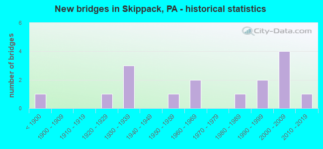
- New bridges - historical statistics
- 1Before 1900
- 11920-1929
- 31930-1939
- 11950-1959
- 21960-1969
- 11980-1989
- 21990-1999
- 42000-2009
- 12010-2019

- Reconstructed bridges - Historical Statistics
- 21980-1989
- 01990-1999
- 12000-2009
- 12010-2019


- Bridge Condition - Deck
- 30.8%Very good
- 23.1%Good
- 23.1%Satisfactory
- 23.1%Fair

- Bridge Condition - Superstructure
- 42.9%Very good
- 7.1%Good
- 14.3%Satisfactory
- 21.4%Fair
- 14.3%Poor

- Bridge Condition - Substructure
- 7.1%Very good
- 50.0%Good
- 21.4%Satisfactory
- 7.1%Fair
- 14.3%Poor

- Bridge Condition - Channel
- 37.5%Satisfactory
- 37.5%Fair
- 25.0%Poor
Find on map >> Show street view
Structure Number: 272, Location: W. OF PA 113 15A13/3142E4 (Lat: 40.229814, Lng: -75.407339), Route carried "on" structure: State highway 73, Year Built: 1966, Status: Open, Structure Length: 0.67m (2.20ft), Average Daily Traffic: 12,282 (year 2021), Truck Traffic: 4%, Average Future Daily Traffic: 17,065 (year 2032), Design Load: HS 20, Features Intersected: BRANCH SKIPPACK CREEK, Facility Carried by Structure: SKIPPACK PIKE
Minimum Vertical Clearance: 30+ m (98+ ft), Kilometerpoint: 20.287, Lanes on structure: 2, Base Highway Network: Yes, Owner: State Highway Agency, Approaching Roadway Width: 12.5m (41.0ft), Skew: 3 degrees, Material/Design: Concrete, Design/Construction: Slab, Number Of Spans In Main Unit: 1, Length of Maximum Span: 6.4m (21.0ft), Curb or Sidewalk Widths: Left: 0.4m (1.3ft), Right: 0.4m (1.3ft), Curb-To-Curb Width: 12.3m (40.4ft), Out-to-Out Width: 13.4m (44.0ft)
Condition: Deck: Satisfactory, Superstructure: Satisfactory, Substructure: Satisfactory, Channel: Fair, Operating Rating: 60.8 metric tons, Method Used To Determine Operating Rating: Load Factor (LF), Inventory Rating: 36.3 metric tons, Method Used To Determine Inventory Rating: Load Factor (LF), Structural Evaluation: Equal to present minimum criteria, Deck Geometry: Somewhat better than minimum adequacy, Waterway Adequacy: High priority of corrective action, Approach Roadway Alignment: Equal to present desirable criteria, Length Of Structure Improvement: 1.30m (4.27ft), Designated Inspection Frequency: Every 24 months, Inspection Date: March 2021, Deck Structure Type: Concrete Cast-file-Place, Wearing Surface/Protective System: Wearing Surface: Monolithic Concrete
Find on map >> Show street view
Structure Number: 27783, Location: NW OF 363 21C8/3142H10 (Lat: 40.188878, Lng: -75.388922), Route carried "on" structure: State highway , Year Built: 1932, Status: Open, Structure Length: 0.79m (2.59ft), Average Daily Traffic: 1,051 (year 2020), Truck Traffic: 9%, Average Future Daily Traffic: 1,648 (year 2032), Design Load: H 20, Features Intersected: BRANCH SKIPPACK CREEK, Facility Carried by Structure: WATER STREET ROAD
Minimum Vertical Clearance: 30+ m (98+ ft), Kilometerpoint: 2.115, Lanes on structure: 2, Owner: State Highway Agency, Approaching Roadway Width: 5.8m (19.0ft), Skew: 1 degrees, Material/Design: Concrete continuous, Design/Construction: Stringer/Multi-beam, Number Of Spans In Main Unit: 1, Length of Maximum Span: 7.3m (24.0ft), Curb-To-Curb Width: 7.4m (24.3ft), Out-to-Out Width: 8.5m (27.9ft)
Condition: Deck: Fair, Superstructure: Poor, Substructure: Poor, Channel: Poor, Operating Rating: 54.4 metric tons, Method Used To Determine Operating Rating: Load Factor (LF), Inventory Rating: 32.7 metric tons, Method Used To Determine Inventory Rating: Load Factor (LF), Structural Evaluation: Meets minimum limits, Deck Geometry: Meets minimum limits, Waterway Adequacy: Better than present minimum criteria, Approach Roadway Alignment: Equal to present desirable criteria, Length Of Structure Improvement: 1.40m (4.59ft), Designated Inspection Frequency: Every 24 months, Inspection Date: April 2021, Bridge Improvement Cost: $6,000, Roadway Improvement Cost: $16,000, Total Project Cost: $75,000, Deck Structure Type: Concrete Cast-file-Place, Wearing Surface/Protective System: Wearing Surface: Bituminous
Find on map >> Show street view
Structure Number: 27795, Location: 1MI.S.OF PA 73 21B2 (Lat: 40.222314, Lng: -75.397711), Route carried "on" structure: State highway , Year Built: 1830, Year Reconstructed: 1989, Status: Open, Structure Length: 0.73m (2.40ft), Average Daily Traffic: 2,745 (year 2022), Truck Traffic: 9%, Average Future Daily Traffic: 2,025 (year 2032), Design Load: H 15, Features Intersected: BRANCH SKIPPACK CREEK, Facility Carried by Structure: COLLEGEVILLE ROAD
Minimum Vertical Clearance: 30+ m (98+ ft), Kilometerpoint: 0.772, Lanes on structure: 2, Owner: State Highway Agency, Approaching Roadway Width: 6.1m (20.0ft), Material/Design: Masonry, Design/Construction: Arch - Deck, Number Of Spans In Main Unit: 1, Length of Maximum Span: 6.1m (20.0ft), Curb-To-Curb Width: 5.2m (17.1ft), Out-to-Out Width: 6.1m (20.0ft)
Condition: Superstructure: Poor, Substructure: Poor, Channel: Fair, Operating Rating: 52.6 metric tons, Method Used To Determine Operating Rating: Field evaluation and documented engineering judgment, Inventory Rating: 26.3 metric tons, Method Used To Determine Inventory Rating: Field evaluation and documented engineering judgment, Structural Evaluation: Meets minimum limits, Deck Geometry: High priority of replacement, Waterway Adequacy: Better than present minimum criteria, Approach Roadway Alignment: Equal to present desirable criteria, Length Of Structure Improvement: 1.40m (4.59ft), Designated Inspection Frequency: Every 24 months, Other Special Inspection Frequency: Every 12 months, Inspection Date: March 2021, Other Special Inspection Date: March 2021, Bridge Improvement Cost: $23,000, Roadway Improvement Cost: $68,000, Total Project Cost: $312,000
Find on map >> Show street view
Structure Number: 28072, Location: 1.13 MI NE SR-73 3142-K3 (Lat: 40.237494, Lng: -75.378575), Route carried "on" structure: City street , Year Built: 1969, Year Reconstructed: 2015, Status: Open, Structure Length: 0.82m (2.69ft), Average Daily Traffic: 240 (year 2012), Average Future Daily Traffic: 278 (year 2032), Design Load: HL 93, Features Intersected: BRANCH OF SKIPPACK CREEK, Facility Carried by Structure: STORE ROAD T-403
Minimum Vertical Clearance: 30+ m (98+ ft), Kilometerpoint: 0.000, Lanes on structure: 2, Owner: Town or Township Highway Agency, Approaching Roadway Width: 5.8m (19.0ft), Material/Design: Prestressed concrete, Design/Construction: Box Beam or Girders - Single/Spread, Number Of Spans In Main Unit: 1, Length of Maximum Span: 7.6m (24.9ft), Curb-To-Curb Width: 6.3m (20.7ft), Out-to-Out Width: 6.5m (21.3ft)
Condition: Deck: Very good, Superstructure: Very good, Substructure: Satisfactory, Channel: Fair, Operating Rating: 67.1 metric tons, Method Used To Determine Operating Rating: Load and Resistance Factor (LRFR), Inventory Rating: 51.7 metric tons, Method Used To Determine Inventory Rating: Load and Resistance Factor (LRFR), Structural Evaluation: Equal to present minimum criteria, Waterway Adequacy: Equal to present desirable criteria, Approach Roadway Alignment: Equal to present desirable criteria, Length Of Structure Improvement: 1.10m (3.61ft), Designated Inspection Frequency: Every 24 months, Underwater Inspection Frequency: Every 24 months, Inspection Date: July 2021, Underwater Inspection Date: July 2021, Bridge Improvement Cost: $10,000, Roadway Improvement Cost: $33,000, Total Project Cost: $136,000, Wearing Surface/Protective System: Wearing Surface: Monolithic Concrete, Deck Protection: Epoxy Coated Reinforcing
Find on map >> Show street view
Structure Number: 28095, Location: MENSCH ROAD 3142-G5 (Lat: 40.222917, Lng: -75.399497), Route carried "on" structure: City street , Year Built: 1920, Year Reconstructed: 2011, Status: Open, Structure Length: 0.94m (3.08ft), Average Daily Traffic: 365 (year 2015), Truck Traffic: 2%, Average Future Daily Traffic: 450 (year 2035), Design Load: HL 93, Features Intersected: TRIB OF SKIPPACK CREEK, Facility Carried by Structure: MENSCH ROAD
Minimum Vertical Clearance: 30+ m (98+ ft), Kilometerpoint: 0.000, Lanes on structure: 2, Owner: Town or Township Highway Agency, Approaching Roadway Width: 5.8m (19.0ft), Skew: 3 degrees, Material/Design: Prestressed concrete, Design/Construction: Box Beam or Girders - Single/Spread, Number Of Spans In Main Unit: 1, Length of Maximum Span: 8.8m (28.9ft), Curb or Sidewalk Widths: Left: 0.2m (0.7ft), Right: 0.2m (0.7ft), Curb-To-Curb Width: 5.9m (19.4ft), Out-to-Out Width: 6.9m (22.6ft)
Condition: Deck: Very good, Superstructure: Very good, Substructure: Good, Channel: Satisfactory, Operating Rating: 57.7 metric tons, Method Used To Determine Operating Rating: Assigned ratings based on Load and Resistance Factor Design (LRFD) reported by rating factor (RF) using HL93 loadings, Inventory Rating: 36.3 metric tons, Method Used To Determine Inventory Rating: Assigned ratings based on Load and Resistance Factor Design (LRFD) reported by rating factor (RF) using HL93 loadings, Structural Evaluation: Better than present minimum criteria, Deck Geometry: High priority of corrective action, Waterway Adequacy: Equal to present minimum criteria, Approach Roadway Alignment: Better than present minimum criteria, Length Of Structure Improvement: 1.10m (3.61ft), Designated Inspection Frequency: Every 24 months, Inspection Date: June 2021, Bridge Improvement Cost: $20,000, Roadway Improvement Cost: $58,000, Total Project Cost: $268,000, Deck Structure Type: Concrete Cast-file-Place, Wearing Surface/Protective System: Wearing Surface: Monolithic Concrete, Deck Protection: Epoxy Coated Reinforcing
Find on map >> Show street view
Structure Number: 41899, Location: EV-BURG ST PK 21C5/3142H8 (Lat: 40.205064, Lng: -75.388528), Route carried "on" structure: State highway , Year Built: 2003, Status: Open, Structure Length: 5.12m (16.80ft), Average Daily Traffic: 1,083 (year 2020), Truck Traffic: 9%, Average Future Daily Traffic: 3,911 (year 2032), Design Load: HS 25 or greater, Features Intersected: SKIPPACK CREEK, Facility Carried by Structure: ANDERS ROAD
Minimum Vertical Clearance: 30+ m (98+ ft), Kilometerpoint: 9.041, Lanes on structure: 2, Owner: State Highway Agency, Approaching Roadway Width: 11.0m (36.1ft), Skew: 1 degrees, Material/Design: Prestressed concrete continuous, Design/Construction: Box Beam or Girders - Single/Spread, Number Of Spans In Main Unit: 2, Length of Maximum Span: 25.0m (82.0ft), Curb or Sidewalk Widths: Left: 0.2m (0.7ft), Right: 0.2m (0.7ft), Curb-To-Curb Width: 10.5m (34.4ft), Out-to-Out Width: 12.2m (40.0ft)
Condition: Deck: Good, Superstructure: Very good, Substructure: Good, Channel: Satisfactory, Inventory Rating: 43.5 metric tons, Method Used To Determine Inventory Rating: Load Factor (LF), Structural Evaluation: Better than present minimum criteria, Deck Geometry: Equal to present minimum criteria, Waterway Adequacy: Better than present minimum criteria, Approach Roadway Alignment: Meets minimum limits, Length Of Structure Improvement: 6.10m (20.01ft), Designated Inspection Frequency: Every 24 months, Inspection Date: December 2019, Deck Structure Type: Concrete Cast-file-Place, Wearing Surface/Protective System: Wearing Surface: Monolithic Concrete, Deck Protection: Epoxy Coated Reinforcing
Find on map >> Show street view
Structure Number: 43229, Location: NE SKIPPACK 15E13/3142K3 (Lat: 40.234525, Lng: -75.377256), Route carried "on" structure: State highway , Year Built: 2005, Status: Open, Structure Length: 2.50m (8.20ft), Average Daily Traffic: 548 (year 2022), Truck Traffic: 4%, Average Future Daily Traffic: 799 (year 2032), Design Load: HL 93, Features Intersected: SKIPPACK CREEK, Facility Carried by Structure: BRIDGE ROAD
Minimum Vertical Clearance: 30+ m (98+ ft), Kilometerpoint: 0.000, Lanes on structure: 2, Owner: State Highway Agency, Approaching Roadway Width: 9.1m (29.9ft), Material/Design: Steel, Design/Construction: Stringer/Multi-beam, Number Of Spans In Main Unit: 1, Length of Maximum Span: 24.4m (80.1ft), Curb or Sidewalk Widths: Left: 0.2m (0.7ft), Right: 0.2m (0.7ft), Curb-To-Curb Width: 9.1m (29.9ft), Out-to-Out Width: 10.0m (32.8ft)
Condition: Deck: Good, Superstructure: Very good, Substructure: Good, Channel: Fair, Operating Rating: 83.5 metric tons, Method Used To Determine Operating Rating: Load Factor (LF), Inventory Rating: 49.9 metric tons, Method Used To Determine Inventory Rating: Load Factor (LF), Structural Evaluation: Better than present minimum criteria, Deck Geometry: Equal to present minimum criteria, Waterway Adequacy: Equal to present minimum criteria, Approach Roadway Alignment: Better than present minimum criteria, Designated Inspection Frequency: Every 24 months, Inspection Date: December 2019, Deck Structure Type: Concrete Cast-file-Place, Wearing Surface/Protective System: Wearing Surface: Monolithic Concrete, Deck Protection: Epoxy Coated Reinforcing
Find on map >> Show street view
Structure Number: 4323, Location: N SKIPPACK 15D11/3142J1 (Lat: 40.244431, Lng: -75.381981), Route carried "on" structure: State highway , Year Built: 2005, Status: Open, Structure Length: 2.26m (7.41ft), Average Daily Traffic: 548 (year 2022), Truck Traffic: 4%, Average Future Daily Traffic: 799 (year 2032), Design Load: HL 93, Features Intersected: WEST BR. SKIPPACK CREEK, Facility Carried by Structure: QUARRY ROAD
Minimum Vertical Clearance: 30+ m (98+ ft), Kilometerpoint: 0.528, Lanes on structure: 2, Owner: State Highway Agency, Approaching Roadway Width: 10.4m (34.1ft), Skew: 3 degrees, Material/Design: Prestressed concrete, Design/Construction: Box Beam or Girders - Multiple, Number Of Spans In Main Unit: 1, Length of Maximum Span: 21.9m (71.9ft), Curb or Sidewalk Widths: Left: 0.2m (0.7ft), Right: 0.2m (0.7ft), Curb-To-Curb Width: 10.4m (34.1ft), Out-to-Out Width: 11.4m (37.4ft)
Condition: Deck: Good, Superstructure: Very good, Substructure: Good, Channel: Satisfactory, Operating Rating: 88.9 metric tons, Method Used To Determine Operating Rating: Load Factor (LF), Inventory Rating: 46.3 metric tons, Method Used To Determine Inventory Rating: Load Factor (LF), Structural Evaluation: Better than present minimum criteria, Deck Geometry: Equal to present minimum criteria, Waterway Adequacy: Equal to present minimum criteria, Approach Roadway Alignment: Better than present minimum criteria, Designated Inspection Frequency: Every 24 months, Inspection Date: December 2019, Deck Structure Type: Concrete Cast-file-Place, Wearing Surface/Protective System: Wearing Surface: Monolithic Concrete, Deck Protection: Epoxy Coated Reinforcing
Find on map >> Show street view
Structure Number: 48887, Location: .25MIle N of SR73 3142-B2 (Lat: 40.241100, Lng: -75.425600), Route carried "on" structure: City street , Year Built: 1950, Year Reconstructed: 1980, Status: Open, Structure Length: 0.76m (2.49ft), Average Daily Traffic: 100 (year 2015), Truck Traffic: 1%, Average Future Daily Traffic: 120 (year 2035), Features Intersected: Tributary toPerkiomen Cr, Facility Carried by Structure: Hudnut Road
Minimum Vertical Clearance: 30+ m (98+ ft), Kilometerpoint: 0.000, Lanes on structure: 2, Owner: Town or Township Highway Agency, Approaching Roadway Width: 7.6m (24.9ft), Skew: 3 degrees, Material/Design: Concrete, Design/Construction: Slab, Number Of Spans In Main Unit: 1, Length of Maximum Span: 7.3m (24.0ft), Curb-To-Curb Width: 5.8m (19.0ft), Out-to-Out Width: 6.9m (22.6ft)
Condition: Deck: Satisfactory, Superstructure: Satisfactory, Substructure: Satisfactory, Channel: Poor, Operating Rating: 63.5 metric tons, Method Used To Determine Operating Rating: Field evaluation and documented engineering judgment, Inventory Rating: 38.1 metric tons, Method Used To Determine Inventory Rating: Field evaluation and documented engineering judgment, Structural Evaluation: Equal to present minimum criteria, Waterway Adequacy: High priority of corrective action, Approach Roadway Alignment: Meets minimum limits, Designated Inspection Frequency: Every 24 months, Inspection Date: October 2020, Deck Structure Type: Concrete Cast-file-Place, Wearing Surface/Protective System: Wearing Surface: Bituminous
Find on map >> Show street view
Structure Number: 54281, Location: .22M S of SR 73- 3143B07 (Lat: 40.207378, Lng: -75.365297), Route carried "on" structure: Other road , Year Built: 1980, Status: Open, Structure Length: 1.34m (4.40ft), Average Daily Traffic: 500 (year 2017), Truck Traffic: 1%, Average Future Daily Traffic: 600 (year 2037), Design Load: HS 25 or greater, Features Intersected: Zacharias Creek, Facility Carried by Structure: Green Hill Road
Minimum Vertical Clearance: 30+ m (98+ ft), Kilometerpoint: 0.000, Lanes on structure: 2, Owner: Town or Township Highway Agency, Approaching Roadway Width: 7.6m (24.9ft), Material/Design: Wood or Timber, Design/Construction: Stringer/Multi-beam, Number Of Spans In Main Unit: 1, Length of Maximum Span: 12.8m (42.0ft), Curb-To-Curb Width: 8.5m (27.9ft), Out-to-Out Width: 8.5m (27.9ft)
Condition: Deck: Very good, Superstructure: Good, Substructure: Good, Channel: Satisfactory, Operating Rating: 49.0 metric tons, Method Used To Determine Operating Rating: Field evaluation and documented engineering judgment, Inventory Rating: 32.7 metric tons, Method Used To Determine Inventory Rating: Field evaluation and documented engineering judgment, Structural Evaluation: Better than present minimum criteria, Deck Geometry: Somewhat better than minimum adequacy, Waterway Adequacy: Better than present minimum criteria, Approach Roadway Alignment: Equal to present desirable criteria, Designated Inspection Frequency: Every 24 months, Inspection Date: April 2021, Deck Structure Type: Wood or Timber, Wearing Surface/Protective System: Wearing Surface: Wood or Timber
Find on map >> Show street view
Structure Number: 54282, Location: .3 M S of SR 73-3143C8 (Lat: 40.203414, Lng: -75.358931), Route carried "on" structure: Other road , Year Built: 1930, Status: Open, Structure Length: 1.77m (5.81ft), Average Daily Traffic: 500 (year 2017), Truck Traffic: 2%, Average Future Daily Traffic: 700 (year 2037), Design Load: HS 20, Features Intersected: Zacharias Creek, Facility Carried by Structure: Hollow Road
Minimum Vertical Clearance: 30+ m (98+ ft), Kilometerpoint: 0.000, Lanes on structure: 2, Owner: Town or Township Highway Agency, Approaching Roadway Width: 6.4m (21.0ft), Material/Design: Steel, Design/Construction: Stringer/Multi-beam, Number Of Spans In Main Unit: 2, Length of Maximum Span: 7.6m (24.9ft), Curb-To-Curb Width: 6.1m (20.0ft), Out-to-Out Width: 7.1m (23.3ft)
Condition: Deck: Satisfactory, Superstructure: Fair, Substructure: Fair, Channel: Poor, Operating Rating: 49.0 metric tons, Method Used To Determine Operating Rating: Field evaluation and documented engineering judgment, Inventory Rating: 32.7 metric tons, Method Used To Determine Inventory Rating: Field evaluation and documented engineering judgment, Structural Evaluation: Somewhat better than minimum adequacy, Deck Geometry: High priority of corrective action, Waterway Adequacy: Better than present minimum criteria, Approach Roadway Alignment: Meets minimum limits, Designated Inspection Frequency: Every 24 months, Underwater Inspection Frequency: Every 24 months, Inspection Date: March 2021, Underwater Inspection Date: August 2020, Deck Structure Type: Concrete Cast-file-Place, Wearing Surface/Protective System: Wearing Surface: Bituminous
Find on map >> Show street view
Structure Number: 54283, Location: Fawn/Zacharias Rd 3143-C8 (Lat: 40.201967, Lng: -75.360008), Route carried "on" structure: Other road , Year Built: 1996, Status: Open, Structure Length: 0.98m (3.22ft), Average Daily Traffic: 500 (year 2017), Truck Traffic: 2%, Average Future Daily Traffic: 700 (year 2037), Design Load: HS 25 or greater, Features Intersected: Tr Zacharias Creek, Facility Carried by Structure: Hollow Road
Minimum Vertical Clearance: 30+ m (98+ ft), Kilometerpoint: 0.000, Lanes on structure: 2, Owner: Town or Township Highway Agency, Approaching Roadway Width: 8.2m (26.9ft), Skew: 3 degrees, Material/Design: Prestressed concrete, Design/Construction: Box Beam or Girders - Multiple, Number Of Spans In Main Unit: 1, Length of Maximum Span: 9.4m (30.8ft), Curb-To-Curb Width: 8.3m (27.2ft), Out-to-Out Width: 8.6m (28.2ft)
Condition: Deck: Fair, Superstructure: Fair, Substructure: Good, Channel: Fair, Operating Rating: 49.0 metric tons, Method Used To Determine Operating Rating: Field evaluation and documented engineering judgment, Inventory Rating: 32.7 metric tons, Method Used To Determine Inventory Rating: Field evaluation and documented engineering judgment, Structural Evaluation: Somewhat better than minimum adequacy, Deck Geometry: Somewhat better than minimum adequacy, Waterway Adequacy: Better than present minimum criteria, Approach Roadway Alignment: Somewhat better than minimum adequacy, Designated Inspection Frequency: Every 24 months, Inspection Date: March 2021, Deck Structure Type: Concrete Cast-file-Place, Wearing Surface/Protective System: Wearing Surface: Bituminous
Find on map >> Show street view
Structure Number: 54284, Location: Doe Brook Lane/Fawn3143C8 (Lat: 40.200839, Lng: -75.360056), Route carried "on" structure: Other road , Year Built: 1996, Status: Open, Structure Length: 0.82m (2.69ft), Average Daily Traffic: 500 (year 2017), Truck Traffic: 2%, Average Future Daily Traffic: 600 (year 2027), Design Load: HS 25 or greater, Features Intersected: Trib of Zacharias Creek, Facility Carried by Structure: Hollow Road
Minimum Vertical Clearance: 30+ m (98+ ft), Kilometerpoint: 0.000, Lanes on structure: 2, Owner: Town or Township Highway Agency, Approaching Roadway Width: 7.9m (25.9ft), Skew: 2 degrees, Material/Design: Prestressed concrete, Design/Construction: Box Beam or Girders - Multiple, Number Of Spans In Main Unit: 1, Length of Maximum Span: 7.9m (25.9ft), Curb-To-Curb Width: 8.3m (27.2ft), Out-to-Out Width: 9.8m (32.2ft)
Condition: Deck: Fair, Superstructure: Fair, Substructure: Good, Channel: Satisfactory, Operating Rating: 49.0 metric tons, Method Used To Determine Operating Rating: Field evaluation and documented engineering judgment, Inventory Rating: 32.7 metric tons, Method Used To Determine Inventory Rating: Field evaluation and documented engineering judgment, Structural Evaluation: Somewhat better than minimum adequacy, Deck Geometry: Somewhat better than minimum adequacy, Waterway Adequacy: Equal to present desirable criteria, Approach Roadway Alignment: Equal to present desirable criteria, Designated Inspection Frequency: Every 24 months, Inspection Date: March 2021, Deck Structure Type: Concrete Cast-file-Place, Wearing Surface/Protective System: Wearing Surface: Bituminous
Find on map >> Show street view
Structure Number: 54285, Location: .2 M S of SR 4005-3142G10 (Lat: 40.189683, Lng: -75.397083), Route carried "on" structure: Other road , Year Built: 2003, Status: Open, Structure Length: 0.85m (2.79ft), Average Daily Traffic: 1,300 (year 2017), Truck Traffic: 3%, Average Future Daily Traffic: 1,600 (year 2037), Design Load: HL 93, Features Intersected: Tri to Skippack Creek, Facility Carried by Structure: N Grange Avenue
Minimum Vertical Clearance: 30+ m (98+ ft), Kilometerpoint: 0.000, Lanes on structure: 2, Owner: Town or Township Highway Agency, Approaching Roadway Width: 6.7m (22.0ft), Material/Design: Concrete, Design/Construction: Culvert, Number Of Spans In Main Unit: 1, Length of Maximum Span: 8.5m (27.9ft)
Condition: Channel: Poor, Culverts: Fair, Operating Rating: 49.0 metric tons, Method Used To Determine Operating Rating: Field evaluation and documented engineering judgment, Inventory Rating: 32.7 metric tons, Method Used To Determine Inventory Rating: Field evaluation and documented engineering judgment, Structural Evaluation: Somewhat better than minimum adequacy, Waterway Adequacy: Better than present minimum criteria, Approach Roadway Alignment: Equal to present desirable criteria, Designated Inspection Frequency: Every 24 months, Underwater Inspection Frequency: Every 24 months, Inspection Date: March 2021, Underwater Inspection Date: June 2021
Find on map >> Show street view
Structure Number: 56129, Location: KULPSVILLE 21D1/3142J4 (Lat: 40.229314, Lng: -75.380917), Route carried "on" structure: State highway , Year Built: 2019, Status: Open, Structure Length: 3.90m (12.80ft), Average Daily Traffic: 5,780 (year 2022), Truck Traffic: 4%, Average Future Daily Traffic: 6,417 (year 2032), Design Load: HL 93, Features Intersected: SKIPPACK CREEK, Facility Carried by Structure: OLD FORTY FOOT RD.
Minimum Vertical Clearance: 30+ m (98+ ft), Kilometerpoint: 0.684, Lanes on structure: 2, Owner: State Highway Agency, Approaching Roadway Width: 9.8m (32.2ft), Skew: 1 degrees, Material/Design: Prestressed concrete continuous, Design/Construction: Box Beam or Girders - Single/Spread, Number Of Spans In Main Unit: 2, Length of Maximum Span: 18.9m (62.0ft), Curb-To-Curb Width: 9.8m (32.2ft), Out-to-Out Width: 11.0m (36.1ft)
Condition: Deck: Very good, Superstructure: Very good, Substructure: Very good, Channel: Satisfactory, Operating Rating: 46.0 metric tons, Method Used To Determine Operating Rating: Assigned ratings based on Load and Resistance Factor Design (LRFD) reported by rating factor (RF) using HL93 loadings, Inventory Rating: 35.3 metric tons, Method Used To Determine Inventory Rating: Assigned ratings based on Load and Resistance Factor Design (LRFD) reported by rating factor (RF) using HL93 loadings, Structural Evaluation: Equal to present desirable criteria, Deck Geometry: Meets minimum limits, Waterway Adequacy: Better than present minimum criteria, Approach Roadway Alignment: Equal to present desirable criteria, Designated Inspection Frequency: Every 24 months, Inspection Date: Febuary 2021, Deck Structure Type: Concrete Cast-file-Place, Wearing Surface/Protective System: Wearing Surface: Monolithic Concrete, Deck Protection: Epoxy Coated Reinforcing
Find on map >> Show street view
Structure Number: 57097, Location: 0.1 MI SW OF SKIPPACK PK (Lat: 40.220306, Lng: -75.389000), Route carried "on" structure: City street , Year Built: 1932, Status: Open, Structure Length: 0.67m (2.20ft), Average Daily Traffic: 2,411 (year 2017), Truck Traffic: 1%, Average Future Daily Traffic: 1,700 (year 2037), Design Load: HS 20, Features Intersected: BRANCH OF SKIPPACK CREEK, Facility Carried by Structure: EVANSBURG ROAD
Minimum Vertical Clearance: 30+ m (98+ ft), Kilometerpoint: 0.000, Lanes on structure: 2, Owner: Town or Township Highway Agency, Approaching Roadway Width: 6.7m (22.0ft), Material/Design: Concrete, Design/Construction: Culvert, Number Of Spans In Main Unit: 1, Length of Maximum Span: 6.1m (20.0ft), Curb-To-Curb Width: 6.7m (22.0ft), Out-to-Out Width: 10.3m (33.8ft)
Condition: Channel: Fair, Culverts: Fair, Operating Rating: 75.3 metric tons, Method Used To Determine Operating Rating: Field evaluation and documented engineering judgment, Inventory Rating: 45.4 metric tons, Method Used To Determine Inventory Rating: Field evaluation and documented engineering judgment, Structural Evaluation: Somewhat better than minimum adequacy, Deck Geometry: High priority of replacement, Waterway Adequacy: Better than present minimum criteria, Approach Roadway Alignment: Equal to present desirable criteria, Designated Inspection Frequency: Every 24 months, Inspection Date: January 2020