Bridge Statistics for Sixteen Mile Stand, Ohio (OH)
Condition, Traffic, Stress, Structural Evaluation, Project Costs
- National Bridge Inventory (NBI) Statistics
- 11Number of bridges
- 157ft / 47.6mTotal length
- 559,257Total average daily traffic
- 59,412Total average daily truck traffic
- National Bridge Inventory (NBI) Registered Bridges for Sixteen Mile Stand
- No street view available for this location
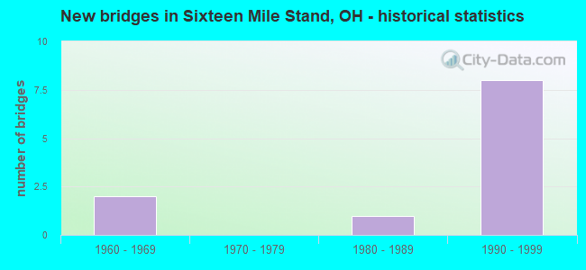
- New bridges - historical statistics
- 21960-1969
- 11980-1989
- 81990-1999


- Bridge Condition - Deck
- 60.0%Very good
- 40.0%Good

- Bridge Condition - Superstructure
- 60.0%Very good
- 20.0%Good
- 20.0%Satisfactory

- Bridge Condition - Substructure
- 60.0%Very good
- 20.0%Good
- 20.0%Satisfactory
Find on map >> Show street view
Structure Number: 310762, Location: 1 MI N OF IR 275 (Lat: 39.280250, Lng: -84.335319), Route carried "on" structure: County highway C0277, Year Built: 1965, Status: Open, Structure Length: 10.48m (34.38ft), Average Daily Traffic: 21,202 (year 2018), Truck Traffic: 5%, Average Future Daily Traffic: 173,991 (year 2038), Design Load: H 20, Features Intersected: I71, Facility Carried by Structure: SNIDER RD C277
Minimum Vertical Clearance: 30+ m (98+ ft), Kilometerpoint: 16.898, Lanes on structure: 2, Lanes under structure: 6, Owner: State Highway Agency, Approaching Roadway Width: 7.3m (24.0ft), Skew: 3 degrees, Material/Design: Steel continuous, Design/Construction: Stringer/Multi-beam, Number Of Spans In Main Unit: 4, Length of Maximum Span: 31.2m (102.4ft), Curb-To-Curb Width: 8.5m (27.9ft), Out-to-Out Width: 10.5m (34.4ft)
Condition: Deck: Good, Superstructure: Satisfactory, Substructure: Satisfactory, Operating Rating: 42.1 metric tons, Method Used To Determine Operating Rating: Allowable Stress (AS) rating reported by rating factor (RF) method using MS18 loading, Inventory Rating: 32.4 metric tons, Method Used To Determine Inventory Rating: Allowable Stress (AS) rating reported by rating factor (RF) method using MS18 loading, Structural Evaluation: Equal to present minimum criteria, Deck Geometry: Meets minimum limits, Underclear: Somewhat better than minimum adequacy, Approach Roadway Alignment: Better than present minimum criteria, Designated Inspection Frequency: Every 12 months, Inspection Date: March 2021, Deck Structure Type: Concrete Cast-file-Place, Wearing Surface/Protective System: Wearing Surface: Integral Concrete
Find on map >> Show street view
Structure Number: 3107752, Location: AT THE HAM\WAR CO LINE (Lat: 39.292511, Lng: -84.317689), Route carried "on" structure: Interstate 71, Year Built: 1994, Status: Open, Structure Length: 8.93m (29.30ft), Average Daily Traffic: 62,677 (year 2018), Truck Traffic: 14%, Average Future Daily Traffic: 86,996 (year 2038), Design Load: HS 20+Mod, Features Intersected: FIELDS ERTEL RD
Minimum Vertical Clearance: 30+ m (98+ ft), Kilometerpoint: 32.010, Lanes on structure: 3, Lanes under structure: 4, Base Highway Network: Yes, Owner: State Highway Agency, Approaching Roadway Width: 19.5m (64.0ft), Skew: 4 degrees, Material/Design: Steel continuous, Design/Construction: Stringer/Multi-beam, Number Of Spans In Main Unit: 4, Length of Maximum Span: 26.7m (87.6ft), Curb-To-Curb Width: 19.5m (64.0ft), Out-to-Out Width: 20.4m (66.9ft)
Condition: Deck: Good, Superstructure: Good, Substructure: Good, Operating Rating: 58.3 metric tons, Method Used To Determine Operating Rating: Load and Resistance Factor Rating (LRFR) rating reported by rating factor(RF) method using HL-93 loadings, Inventory Rating: 45.4 metric tons, Method Used To Determine Inventory Rating: Load and Resistance Factor Rating (LRFR) rating reported by rating factor(RF) method using HL-93 loadings, Structural Evaluation: Better than present minimum criteria, Deck Geometry: Superior to present desirable criteria, Underclear: Better than present minimum criteria, Approach Roadway Alignment: Superior to present desirable criteria, Designated Inspection Frequency: Every 24 months, Inspection Date: March 2021, Deck Structure Type: Concrete Cast-file-Place, Wearing Surface/Protective System: Wearing Surface: Integral Concrete, Deck Protection: Epoxy Coated Reinforcing
Find on map >> Show street view
Structure Number: 310776, Location: AT THE HAM\WAR CO LINE (Lat: 39.292500, Lng: -84.317269), Route carried "on" structure: Interstate 71, Year Built: 1994, Status: Open, Structure Length: 8.93m (29.30ft), Average Daily Traffic: 62,677 (year 2018), Truck Traffic: 14%, Average Future Daily Traffic: 86,996 (year 2038), Design Load: HS 20+Mod, Features Intersected: FIELDS ERTEL RD
Minimum Vertical Clearance: 30+ m (98+ ft), Kilometerpoint: 32.010, Lanes on structure: 3, Lanes under structure: 4, Base Highway Network: Yes, Owner: State Highway Agency, Approaching Roadway Width: 30.2m (99.1ft), Skew: 4 degrees, Material/Design: Steel continuous, Design/Construction: Stringer/Multi-beam, Number Of Spans In Main Unit: 4, Length of Maximum Span: 26.7m (87.6ft), Curb-To-Curb Width: 27.3m (89.6ft), Out-to-Out Width: 29.1m (95.5ft)
Condition: Deck: Very good, Superstructure: Very good, Substructure: Very good, Operating Rating: 58.3 metric tons, Method Used To Determine Operating Rating: Load and Resistance Factor Rating (LRFR) rating reported by rating factor(RF) method using HL-93 loadings, Inventory Rating: 45.4 metric tons, Method Used To Determine Inventory Rating: Load and Resistance Factor Rating (LRFR) rating reported by rating factor(RF) method using HL-93 loadings, Structural Evaluation: Equal to present desirable criteria, Deck Geometry: Superior to present desirable criteria, Underclear: Better than present minimum criteria, Approach Roadway Alignment: Superior to present desirable criteria, Designated Inspection Frequency: Every 24 months, Inspection Date: March 2021, Deck Structure Type: Concrete Cast-file-Place, Wearing Surface/Protective System: Wearing Surface: Integral Concrete, Deck Protection: Epoxy Coated Reinforcing
Find on map >> Show street view
Structure Number: 3133745, Location: BETW. SNIDER - I 71 (Lat: 39.293069, Lng: -84.326381), Route carried "on" structure: Other road C0004, Year Built: 1980, Status: Open, Structure Length: 0.79m (2.59ft), Average Daily Traffic: 51,591 (year 2015), Truck Traffic: 7%, Average Future Daily Traffic: 71,608 (year 2035), Design Load: HS 20+Mod, Features Intersected: POLK CREEK BRANCH, Facility Carried by Structure: FIELDS ERTEL ROAD
Minimum Vertical Clearance: 30+ m (98+ ft), Kilometerpoint: 5.697, Lanes on structure: 2, Owner: County Highway Agency, Approaching Roadway Width: 9.8m (32.2ft), Skew: 3 degrees, Material/Design: Concrete, Design/Construction: Culvert, Number Of Spans In Main Unit: 3, Length of Maximum Span: 1.8m (5.9ft)
Condition: Channel: Satisfactory, Culverts: Satisfactory, Operating Rating: 97.2 metric tons, Method Used To Determine Operating Rating: Load Factor (LF) rating reported by rating factor (RF) method using MS18 loading, Inventory Rating: 68.0 metric tons, Method Used To Determine Inventory Rating: Load Factor (LF) rating reported by rating factor (RF) method using MS18 loading, Structural Evaluation: Equal to present minimum criteria, Waterway Adequacy: Better than present minimum criteria, Approach Roadway Alignment: Equal to present desirable criteria, Designated Inspection Frequency: Every 12 months, Inspection Date: October 2021
Find on map >> Show street view
Structure Number: 8301697, Location: .09 MI N OF HAM/WAR LINE (Lat: 39.293739, Lng: -84.315989), Route carried "on" structure: Interstate 71, Year Built: 1994, Status: Open, Structure Length: 9.26m (30.38ft), Average Daily Traffic: 39,294 (year 2015), Truck Traffic: 11%, Average Future Daily Traffic: 54,540 (year 2035), Design Load: HS 20+Mod, Features Intersected: MASON-MONTGOMERY RD
Minimum Vertical Clearance: 30+ m (98+ ft), Kilometerpoint: 0.145, Lanes on structure: 6, Lanes under structure: 5, Base Highway Network: Yes, Owner: State Highway Agency, Approaching Roadway Width: 19.5m (64.0ft), Skew: 4 degrees, Material/Design: Steel continuous, Design/Construction: Stringer/Multi-beam, Number Of Spans In Main Unit: 4, Length of Maximum Span: 34.1m (111.9ft), Curb-To-Curb Width: 19.5m (64.0ft), Out-to-Out Width: 20.4m (66.9ft)
Condition: Deck: Very good, Superstructure: Very good, Substructure: Very good, Operating Rating: 42.1 metric tons, Method Used To Determine Operating Rating: Load Factor (LF) rating reported by rating factor (RF) method using MS18 loading, Inventory Rating: 32.4 metric tons, Method Used To Determine Inventory Rating: Load Factor (LF) rating reported by rating factor (RF) method using MS18 loading, Structural Evaluation: Equal to present desirable criteria, Deck Geometry: High priority of replacement, Underclear: Equal to present minimum criteria, Approach Roadway Alignment: Superior to present desirable criteria, Designated Inspection Frequency: Every 24 months, Inspection Date: Febuary 2021, Deck Structure Type: Concrete Cast-file-Place, Wearing Surface/Protective System: Wearing Surface: Integral Concrete, Deck Protection: Epoxy Coated Reinforcing
Find on map >> Show street view
Structure Number: 8301727, Location: .09 MI N OF HAM\WAR LINE (Lat: 39.293450, Lng: -84.316031), Route carried "on" structure: Interstate 71, Year Built: 1994, Status: Open, Structure Length: 9.26m (30.38ft), Average Daily Traffic: 39,294 (year 2015), Truck Traffic: 11%, Average Future Daily Traffic: 54,540 (year 2035), Design Load: HS 20+Mod, Features Intersected: MASON-MONTGOMERY
Minimum Vertical Clearance: 30+ m (98+ ft), Kilometerpoint: 0.145, Lanes on structure: 6, Lanes under structure: 5, Base Highway Network: Yes, Owner: State Highway Agency, Approaching Roadway Width: 29.1m (95.5ft), Skew: 4 degrees, Material/Design: Steel continuous, Design/Construction: Stringer/Multi-beam, Number Of Spans In Main Unit: 4, Length of Maximum Span: 34.1m (111.9ft), Curb-To-Curb Width: 27.3m (89.6ft), Out-to-Out Width: 29.1m (95.5ft)
Condition: Deck: Very good, Superstructure: Very good, Substructure: Very good, Operating Rating: 42.1 metric tons, Method Used To Determine Operating Rating: Load Factor (LF) rating reported by rating factor (RF) method using MS18 loading, Inventory Rating: 32.4 metric tons, Method Used To Determine Inventory Rating: Load Factor (LF) rating reported by rating factor (RF) method using MS18 loading, Structural Evaluation: Equal to present desirable criteria, Deck Geometry: Equal to present minimum criteria, Underclear: Equal to present minimum criteria, Approach Roadway Alignment: Superior to present desirable criteria, Designated Inspection Frequency: Every 24 months, Inspection Date: Febuary 2021, Deck Structure Type: Concrete Cast-file-Place, Wearing Surface/Protective System: Wearing Surface: Integral Concrete, Deck Protection: Epoxy Coated Reinforcing
Find on map >> Show street view
Structure Number: 310762, Location: 1 MI N OF IR 275 (Lat: 39.280250, Lng: -84.335319), Route carried "under" structure: Interstate 71, Year Built: 1965, Structure Length: 0. m, Average Daily Traffic: 125,354 (year 2015), Truck Traffic: 14%, Features Intersected: CR277(SNIDER ROAD), Facility Carried by Structure: SNIDER RD C277
Minimum Vertical Clearance: 5.31m (17.42ft), Kilometerpoint: 29.902, Lanes on structure: 2, Lanes under structure: 6, Material/Design: Steel continuous, Design/Construction: Stringer/Multi-beam, Length of Maximum Span: 31.2m (102.4ft)
Find on map >> Show street view
Structure Number: 3107752, Location: AT THE HAM\WAR CO LINE (Lat: 39.292511, Lng: -84.317689), Route carried "under" structure: Alternate County highway 4, Year Built: 1994, Structure Length: 0. m, Average Daily Traffic: 51,591 (year 2015), Truck Traffic: 7%, Features Intersected: I 71 SOUTHBOUND, Facility Carried by Structure: SB IR 71
Minimum Vertical Clearance: 4.72m (15.49ft), Kilometerpoint: 32.187, Lanes on structure: 3, Lanes under structure: 4, Material/Design: Steel continuous, Design/Construction: Stringer/Multi-beam, Length of Maximum Span: 26.7m (87.6ft)
Find on map >> Show street view
Structure Number: 310776, Location: AT THE HAM\WAR CO LINE (Lat: 39.292500, Lng: -84.317269), Route carried "under" structure: Alternate County highway 4, Year Built: 1994, Structure Length: 0. m, Average Daily Traffic: 51,591 (year 2015), Truck Traffic: 7%, Features Intersected: I 71 NORTHBOUND, Facility Carried by Structure: NB IR 71
Minimum Vertical Clearance: 4.72m (15.49ft), Kilometerpoint: 32.509, Lanes on structure: 3, Lanes under structure: 4, Material/Design: Steel continuous, Design/Construction: Stringer/Multi-beam, Length of Maximum Span: 26.7m (87.6ft)
Find on map >> Show street view
Structure Number: 8301697, Location: .09 MI N OF HAM/WAR LINE (Lat: 39.293739, Lng: -84.315989), Route carried "under" structure: Alternate County highway 21, Year Built: 1994, Structure Length: 0. m, Average Daily Traffic: 26,993 (year 2015), Truck Traffic: 7%, Features Intersected: IR 71 SOUTHBOUND, Facility Carried by Structure: IR 71
Minimum Vertical Clearance: 4.72m (15.49ft), Kilometerpoint: 22.531, Lanes on structure: 6, Lanes under structure: 5, Material/Design: Steel continuous, Design/Construction: Stringer/Multi-beam, Length of Maximum Span: 34.1m (111.9ft)
Find on map >> Show street view
Structure Number: 8301727, Location: .09 MI N OF HAM\WAR LINE (Lat: 39.293450, Lng: -84.316031), Route carried "under" structure: Alternate County highway 21, Year Built: 1994, Structure Length: 0. m, Average Daily Traffic: 26,993 (year 2015), Truck Traffic: 7%, Features Intersected: IR 71 NORTHBOUND, Facility Carried by Structure: IR 71 NB
Minimum Vertical Clearance: 4.72m (15.49ft), Kilometerpoint: 22.531, Lanes on structure: 6, Lanes under structure: 5, Material/Design: Steel continuous, Design/Construction: Stringer/Multi-beam, Length of Maximum Span: 34.1m (111.9ft)