Bridge Statistics for Sinclair, Wyoming (WY)
Condition, Traffic, Stress, Structural Evaluation, Project Costs
- National Bridge Inventory (NBI) Statistics
- 13Number of bridges
- 177ft / 54.5mTotal length
- $16,000Total costs
- 58,989Total average daily traffic
- 31,879Total average daily truck traffic
- National Bridge Inventory (NBI) Registered Bridges for Sinclair
- No street view available for this location
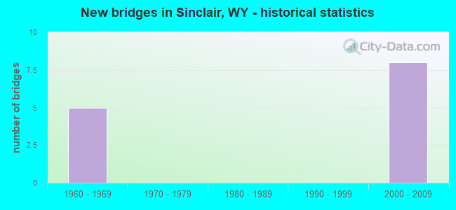
- New bridges - historical statistics
- 51960-1969
- 82000-2009


- Bridge Condition - Deck
- 85.7%Good
- 14.3%Fair

- Bridge Condition - Superstructure
- 85.7%Good
- 14.3%Satisfactory

- Bridge Condition - Substructure
- 57.1%Good
- 28.6%Satisfactory
- 14.3%Fair
Find on map >> Show street view
Structure Number: AUJ, Location: Rawlins - Walcott Jct (Lat: 41.754522, Lng: -106.961564), Route carried "on" structure: Interstate 80, Year Built: 1964, Status: Open, Structure Length: 2.56m (8.40ft), Average Daily Traffic: 7,000 (year 2021), Truck Traffic: 44%, Average Future Daily Traffic: 9,800 (year 2041), Design Load: HS 20+Mod, Features Intersected: CR 347S /Savage Ranch Rd
Minimum Vertical Clearance: 30+ m (98+ ft), Kilometerpoint: 367.016, Lanes on structure: 2, Lanes under structure: 2, Base Highway Network: Yes (Inventory Route: ML8, Subroute: 2), Owner: State Highway Agency, Approaching Roadway Width: 11.6m (38.1ft), Skew: 10 degrees, Material/Design: Concrete continuous, Design/Construction: Slab, Number Of Spans In Main Unit: 3, Length of Maximum Span: 10.7m (35.1ft), Curb-To-Curb Width: 11.6m (38.1ft), Out-to-Out Width: 12.5m (41.0ft)
Condition: Deck: Good, Superstructure: Good, Substructure: Satisfactory, Operating Rating: 59.0 metric tons, Method Used To Determine Operating Rating: Load Factor (LF), Inventory Rating: 35.4 metric tons, Method Used To Determine Inventory Rating: Load Factor (LF), Structural Evaluation: Equal to present minimum criteria, Deck Geometry: Equal to present minimum criteria, Underclear: Meets minimum limits, Approach Roadway Alignment: Equal to present desirable criteria, Designated Inspection Frequency: Every 24 months, Inspection Date: June 2020, Deck Structure Type: Concrete Cast-file-Place, Wearing Surface/Protective System: Wearing Surface: Bituminous, Membrane: Preformed Fabric
Find on map >> Show street view
Structure Number: CID, Location: Sinclair (Lat: 41.778536, Lng: -107.088558), Route carried "on" structure: State highway 76, Year Built: 1960, Status: Open, Structure Length: 6.98m (22.90ft), Average Daily Traffic: 490 (year 2021), Truck Traffic: 10%, Average Future Daily Traffic: 686 (year 2041), Design Load: HS 20, Features Intersected: UPRR
Minimum Vertical Clearance: 30+ m (98+ ft), Kilometerpoint: 356.780, Lanes on structure: 2, Owner: State Highway Agency, Approaching Roadway Width: 12.2m (40.0ft), Skew: 4 degrees, Material/Design: Steel continuous, Design/Construction: Stringer/Multi-beam, Number Of Spans In Main Unit: 3, Length of Maximum Span: 29.6m (97.1ft), Curb-To-Curb Width: 9.8m (32.2ft), Out-to-Out Width: 10.7m (35.1ft)
Condition: Deck: Fair, Superstructure: Satisfactory, Substructure: Fair, Operating Rating: 53.5 metric tons, Method Used To Determine Operating Rating: Load Factor (LF), Inventory Rating: 31.8 metric tons, Method Used To Determine Inventory Rating: Load Factor (LF), Structural Evaluation: Somewhat better than minimum adequacy, Deck Geometry: Equal to present minimum criteria, Underclear: Equal to present minimum criteria, Approach Roadway Alignment: Equal to present desirable criteria, Length Of Structure Improvement: 6.98m (22.90ft), Designated Inspection Frequency: Every 24 months, Inspection Date: June 2020, Bridge Improvement Cost: $11,000, Roadway Improvement Cost: $1,000, Total Project Cost: $16,000 ( Estimate for 2014), Deck Structure Type: Concrete Cast-file-Place, Wearing Surface/Protective System: Wearing Surface: Bituminous
Find on map >> Show street view
Structure Number: DAB, Location: Sinclair (Lat: 41.772581, Lng: -107.082422), Route carried "on" structure: State highway 76, Year Built: 1966, Status: Open, Structure Length: 6.40m (21.00ft), Average Daily Traffic: 490 (year 2021), Truck Traffic: 10%, Average Future Daily Traffic: 686 (year 2041), Design Load: HS 20+Mod, Features Intersected: I-80
Minimum Vertical Clearance: 30+ m (98+ ft), Kilometerpoint: 357.622, Lanes on structure: 2, Lanes under structure: 4, Owner: State Highway Agency, Approaching Roadway Width: 11.3m (37.1ft), Skew: 1 degrees, Material/Design: Steel continuous, Design/Construction: Stringer/Multi-beam, Number Of Spans In Main Unit: 4, Length of Maximum Span: 18.9m (62.0ft), Curb-To-Curb Width: 9.1m (29.9ft), Out-to-Out Width: 10.6m (34.8ft)
Condition: Deck: Good, Superstructure: Good, Substructure: Satisfactory, Operating Rating: 46.3 metric tons, Method Used To Determine Operating Rating: Load Factor (LF), Inventory Rating: 27.2 metric tons, Method Used To Determine Inventory Rating: Load Factor (LF), Structural Evaluation: Equal to present minimum criteria, Deck Geometry: Equal to present minimum criteria, Underclear: Equal to present minimum criteria, Approach Roadway Alignment: Equal to present desirable criteria, Designated Inspection Frequency: Every 24 months, Inspection Date: June 2020, Deck Structure Type: Concrete Cast-file-Place, Wearing Surface/Protective System: Wearing Surface: Latex Concrete
Find on map >> Show street view
Structure Number: KHY, Location: Rawlins - Walcott Jct (Lat: 41.781747, Lng: -107.136206), Route carried "on" structure: Interstate 80, Year Built: 2000, Status: Open, Structure Length: 0.78m (2.56ft), Average Daily Traffic: 7,000 (year 2021), Truck Traffic: 89%, Average Future Daily Traffic: 9,800 (year 2041), Design Load: HS 25 or greater, Features Intersected: Sugar Creek
Minimum Vertical Clearance: 30+ m (98+ ft), Kilometerpoint: 352.155, Lanes on structure: 4, Base Highway Network: Yes (Inventory Route: ML8, Subroute: 1), Owner: State Highway Agency, Approaching Roadway Width: 23.2m (76.1ft), Material/Design: Concrete, Design/Construction: Culvert, Number Of Spans In Main Unit: 3, Length of Maximum Span: 2.4m (7.9ft)
Condition: Channel: Good, Culverts: Satisfactory, Operating Rating: 32.7 metric tons, Method Used To Determine Operating Rating: Field evaluation and documented engineering judgment, Inventory Rating: 32.7 metric tons, Method Used To Determine Inventory Rating: Field evaluation and documented engineering judgment, Structural Evaluation: Equal to present minimum criteria, Waterway Adequacy: Equal to present desirable criteria, Approach Roadway Alignment: Equal to present desirable criteria, Designated Inspection Frequency: Every 24 months, Inspection Date: June 2020
Find on map >> Show street view
Structure Number: KHZ, Location: Rawkins-Walcot Jct (Lat: 41.779219, Lng: -107.125133), Route carried "on" structure: Interstate 80, Year Built: 2001, Status: Open, Structure Length: 6.71m (22.01ft), Average Daily Traffic: 6,750 (year 2021), Truck Traffic: 89%, Average Future Daily Traffic: 9,450 (year 2041), Design Load: HS 25 or greater, Features Intersected: West Sinclair Intg
Minimum Vertical Clearance: 30+ m (98+ ft), Kilometerpoint: 353.145, Lanes on structure: 3, Lanes under structure: 2, Base Highway Network: Yes (Inventory Route: ML8, Subroute: 1), Owner: State Highway Agency, Approaching Roadway Width: 15.6m (51.2ft), Skew: 14 degrees, Material/Design: Steel continuous, Design/Construction: Stringer/Multi-beam, Number Of Spans In Main Unit: 3, Length of Maximum Span: 25.9m (85.0ft), Curb-To-Curb Width: 15.6m (51.2ft), Out-to-Out Width: 16.6m (54.5ft)
Condition: Deck: Good, Superstructure: Good, Substructure: Good, Operating Rating: 89.8 metric tons, Method Used To Determine Operating Rating: Load Factor (LF), Inventory Rating: 55.3 metric tons, Method Used To Determine Inventory Rating: Load Factor (LF), Structural Evaluation: Better than present minimum criteria, Deck Geometry: Somewhat better than minimum adequacy, Underclear: Equal to present desirable criteria, Approach Roadway Alignment: Equal to present desirable criteria, Designated Inspection Frequency: Every 24 months, Inspection Date: May 2021, Deck Structure Type: Concrete Cast-file-Place, Wearing Surface/Protective System: Wearing Surface: Epoxy Overlay, Deck Protection: Epoxy Coated Reinforcing
Find on map >> Show street view
Structure Number: KJA, Location: Rawlins - Walcott Jct (Lat: 41.779244, Lng: -107.124708), Route carried "on" structure: Interstate 80, Year Built: 2000, Status: Open, Structure Length: 6.71m (22.01ft), Average Daily Traffic: 7,000 (year 2021), Truck Traffic: 44%, Average Future Daily Traffic: 9,800 (year 2041), Design Load: HS 25 or greater, Features Intersected: West Sinclair Intg
Minimum Vertical Clearance: 30+ m (98+ ft), Kilometerpoint: 352.957, Lanes on structure: 3, Lanes under structure: 2, Base Highway Network: Yes (Inventory Route: ML8, Subroute: 1), Owner: State Highway Agency, Approaching Roadway Width: 15.6m (51.2ft), Skew: 14 degrees, Material/Design: Steel continuous, Design/Construction: Stringer/Multi-beam, Number Of Spans In Main Unit: 3, Length of Maximum Span: 25.9m (85.0ft), Curb-To-Curb Width: 15.6m (51.2ft), Out-to-Out Width: 16.6m (54.5ft)
Condition: Deck: Good, Superstructure: Good, Substructure: Good, Operating Rating: 89.8 metric tons, Method Used To Determine Operating Rating: Load Factor (LF), Inventory Rating: 55.3 metric tons, Method Used To Determine Inventory Rating: Load Factor (LF), Structural Evaluation: Better than present minimum criteria, Deck Geometry: Somewhat better than minimum adequacy, Underclear: Superior to present desirable criteria, Approach Roadway Alignment: Equal to present desirable criteria, Designated Inspection Frequency: Every 24 months, Inspection Date: May 2021, Deck Structure Type: Concrete Cast-file-Place, Wearing Surface/Protective System: Wearing Surface: Epoxy Overlay, Deck Protection: Other Coated Reinforcing
Find on map >> Show street view
Structure Number: KJB, Location: Rawlins-Walcot Jct (Lat: 41.777828, Lng: -107.123050), Route carried "on" structure: Interstate 80, Year Built: 2001, Status: Open, Structure Length: 12.22m (40.09ft), Average Daily Traffic: 6,750 (year 2021), Truck Traffic: 52%, Average Future Daily Traffic: 9,450 (year 2041), Design Load: HS 25 or greater, Features Intersected: UPRR / WYO 76
Minimum Vertical Clearance: 30+ m (98+ ft), Kilometerpoint: 353.377, Lanes on structure: 2, Lanes under structure: 2, Base Highway Network: Yes (Inventory Route: ML8, Subroute: 1), Owner: State Highway Agency, Approaching Roadway Width: 12.2m (40.0ft), Skew: 14 degrees, Material/Design: Steel continuous, Design/Construction: Stringer/Multi-beam, Number Of Spans In Main Unit: 3, Length of Maximum Span: 42.4m (139.1ft), Curb-To-Curb Width: 12.0m (39.4ft), Out-to-Out Width: 13.2m (43.3ft)
Condition: Deck: Good, Superstructure: Good, Substructure: Good, Operating Rating: 89.8 metric tons, Method Used To Determine Operating Rating: Load Factor (LF), Inventory Rating: 59.9 metric tons, Method Used To Determine Inventory Rating: Load Factor (LF), Structural Evaluation: Better than present minimum criteria, Deck Geometry: Equal to present minimum criteria, Underclear: Superior to present desirable criteria, Approach Roadway Alignment: Equal to present desirable criteria, Designated Inspection Frequency: Every 24 months, Inspection Date: May 2021, Deck Structure Type: Concrete Cast-file-Place, Wearing Surface/Protective System: Wearing Surface: Epoxy Overlay, Deck Protection: Epoxy Coated Reinforcing
Find on map >> Show street view
Structure Number: KJC, Location: Rawlins - Walcott Jct (Lat: 41.777864, Lng: -107.122736), Route carried "on" structure: Interstate 80, Year Built: 2000, Status: Open, Structure Length: 12.13m (39.80ft), Average Daily Traffic: 7,000 (year 2021), Truck Traffic: 44%, Average Future Daily Traffic: 9,800 (year 2041), Design Load: HS 25 or greater, Features Intersected: UPRR / WYO 76
Minimum Vertical Clearance: 30+ m (98+ ft), Kilometerpoint: 353.182, Lanes on structure: 2, Lanes under structure: 2, Base Highway Network: Yes (Inventory Route: ML8, Subroute: 1), Owner: State Highway Agency, Approaching Roadway Width: 12.2m (40.0ft), Skew: 14 degrees, Material/Design: Steel continuous, Design/Construction: Stringer/Multi-beam, Number Of Spans In Main Unit: 3, Length of Maximum Span: 42.4m (139.1ft), Curb-To-Curb Width: 12.0m (39.4ft), Out-to-Out Width: 13.2m (43.3ft)
Condition: Deck: Good, Superstructure: Good, Substructure: Good, Operating Rating: 89.8 metric tons, Method Used To Determine Operating Rating: Load Factor (LF), Inventory Rating: 59.9 metric tons, Method Used To Determine Inventory Rating: Load Factor (LF), Structural Evaluation: Better than present minimum criteria, Deck Geometry: Equal to present minimum criteria, Underclear: Superior to present desirable criteria, Approach Roadway Alignment: Equal to present desirable criteria, Designated Inspection Frequency: Every 24 months, Inspection Date: May 2021, Deck Structure Type: Concrete Cast-file-Place, Wearing Surface/Protective System: Wearing Surface: Epoxy Overlay, Deck Protection: Other Coated Reinforcing
Find on map >> Show street view
Structure Number: DAB, Location: Sinclair (Lat: 41.772581, Lng: -107.082422), Route carried "under" structure: Interstate 80, Year Built: 1966, Structure Length: 0. m, Average Daily Traffic: 6,750 (year 2021), Truck Traffic: 52%, Features Intersected: I-80, Facility Carried by Structure: WYO 76
Minimum Vertical Clearance: 5.23m (17.16ft), Kilometerpoint: 356.949, Lanes on structure: 2, Lanes under structure: 2, Material/Design: Steel continuous, Design/Construction: Stringer/Multi-beam, Length of Maximum Span: 18.9m (62.0ft)
Find on map >> Show street view
Structure Number: DAB, Location: Sinclair (Lat: 41.772581, Lng: -107.082422), Route carried "under" structure: Interstate 80, Year Built: 1966, Structure Length: 0. m, Average Daily Traffic: 7,000 (year 2021), Truck Traffic: 44%, Features Intersected: I-80, Facility Carried by Structure: WYO 76
Minimum Vertical Clearance: 5.26m (17.26ft), Kilometerpoint: 356.713, Lanes on structure: 2, Lanes under structure: 2, Material/Design: Steel continuous, Design/Construction: Stringer/Multi-beam, Length of Maximum Span: 18.9m (62.0ft)
Find on map >> Show street view
Structure Number: KJA, Location: Rawlins - Walcott Jct (Lat: 41.779244, Lng: -107.124708), Route carried "under" structure: State highway 411, Year Built: 2000, Structure Length: 0. m, Average Daily Traffic: 1,881 (year 2021), Truck Traffic: 10%, Features Intersected: West Sinclair Intg, Facility Carried by Structure: I-80 WBL
Minimum Vertical Clearance: 6.07m (19.91ft), Kilometerpoint: 353.718, Lanes on structure: 3, Lanes under structure: 2, Material/Design: Steel continuous, Design/Construction: Stringer/Multi-beam, Length of Maximum Span: 25.9m (85.0ft)
Find on map >> Show street view
Structure Number: KJB, Location: Rawlins-Walcot Jct (Lat: 41.777828, Lng: -107.123050), Route carried "under" structure: State highway 76, Year Built: 2001, Structure Length: 0. m, Average Daily Traffic: 439 (year 2021), Truck Traffic: 2%, Features Intersected: UPRR / WYO 76, Facility Carried by Structure: I-80 EBL
Minimum Vertical Clearance: 5.50m (18.04ft), Kilometerpoint: 353.803, Lanes on structure: 2, Lanes under structure: 2, Material/Design: Steel continuous, Design/Construction: Stringer/Multi-beam, Length of Maximum Span: 42.4m (139.1ft)
Find on map >> Show street view
Structure Number: KJC, Location: Rawlins - Walcott Jct (Lat: 41.777864, Lng: -107.122736), Route carried "under" structure: State highway 76, Year Built: 2000, Structure Length: 0. m, Average Daily Traffic: 439 (year 2021), Truck Traffic: 2%, Features Intersected: UPRR / WYO 76, Facility Carried by Structure: I-80 WBL
Minimum Vertical Clearance: 5.43m (17.81ft), Kilometerpoint: 353.829, Lanes on structure: 2, Lanes under structure: 2, Material/Design: Steel continuous, Design/Construction: Stringer/Multi-beam, Length of Maximum Span: 42.4m (139.1ft)