Bridge Statistics for Sims, Illinois (IL)
Condition, Traffic, Stress, Structural Evaluation, Project Costs
- National Bridge Inventory (NBI) Statistics
- 19Number of bridges
- 144ft / 44.4mTotal length
- 13,575Total average daily traffic
- 1,165Total average daily truck traffic
- 14,778Total future (year 2032) average daily traffic
- National Bridge Inventory (NBI) Registered Bridges for Sims
- No street view available for this location
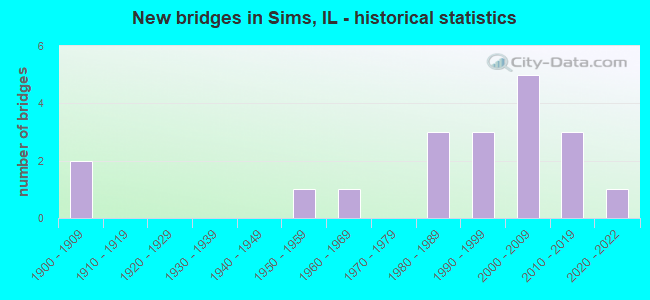
- New bridges - historical statistics
- 21900-1909
- 11950-1959
- 11960-1969
- 31980-1989
- 31990-1999
- 52000-2009
- 32010-2019
- 12020-2022

- Reconstructed bridges - Historical Statistics
- 21970-1979
- 01980-1989
- 11990-1999


- Bridge Condition - Deck
- 11.8%Excellent
- 5.9%Very good
- 52.9%Good
- 5.9%Satisfactory
- 17.6%Fair
- 5.9%Poor

- Bridge Condition - Superstructure
- 11.8%Excellent
- 17.6%Very good
- 41.2%Good
- 11.8%Satisfactory
- 11.8%Fair
- 5.9%Poor

- Bridge Condition - Substructure
- 11.8%Excellent
- 47.1%Very good
- 11.8%Good
- 17.6%Satisfactory
- 11.8%Fair

- Bridge Condition - Channel
- 10.5%Excellent
- 26.3%Very good
- 21.1%Good
- 42.1%Satisfactory

- Bridge Condition - Culverts
- 50.0%Very good
- 50.0%Good
Find on map >> Show street view
Structure Number: 960005, Location: 1.0 MI W SIMS RD (Lat: 38.371911, Lng: -88.549531), Route carried "on" structure: State highway 15, Year Built: 1957, Status: Open, Structure Length: 1.28m (4.20ft), Average Daily Traffic: 2,850 (year 2021), Truck Traffic: 9%, Average Future Daily Traffic: 3,203 (year 2032), Design Load: HS 20, Features Intersected: MILLER CREEK
Minimum Vertical Clearance: 30+ m (98+ ft), Kilometerpoint: 160.673, Lanes on structure: 2, Base Highway Network: Yes, Owner: State Highway Agency, Approaching Roadway Width: 8.7m (28.5ft), Material/Design: Concrete continuous, Design/Construction: Slab, Number Of Spans In Main Unit: 2, Length of Maximum Span: 6.1m (20.0ft), Curb-To-Curb Width: 12.6m (41.3ft), Out-to-Out Width: 13.8m (45.3ft)
Condition: Deck: Poor, Superstructure: Poor, Substructure: Satisfactory, Channel: Satisfactory, Operating Rating: 47.0 metric tons, Method Used To Determine Operating Rating: Load Factor (LF) rating reported by rating factor (RF) method using MS18 loading, Inventory Rating: 28.2 metric tons, Method Used To Determine Inventory Rating: Load Factor (LF) rating reported by rating factor (RF) method using MS18 loading, Structural Evaluation: Meets minimum limits, Deck Geometry: Equal to present minimum criteria, Waterway Adequacy: Equal to present desirable criteria, Approach Roadway Alignment: Equal to present desirable criteria, Designated Inspection Frequency: Every 12 months, Inspection Date: May 2021, Deck Structure Type: Concrete Cast-file-Place, Wearing Surface/Protective System: Wearing Surface: Bituminous
Find on map >> Show street view
Structure Number: 960066, Location: 1.25MI E SIMS RD (Lat: 38.371481, Lng: -88.507647), Route carried "on" structure: State highway 15, Year Built: 2004, Status: Open, Structure Length: 2.13m (6.99ft), Average Daily Traffic: 3,150 (year 2021), Truck Traffic: 8%, Average Future Daily Traffic: 3,518 (year 2032), Design Load: HS 20, Features Intersected: DRY FORK OVERFLOW
Minimum Vertical Clearance: 30+ m (98+ ft), Kilometerpoint: 164.326, Lanes on structure: 2, Base Highway Network: Yes, Owner: State Highway Agency, Approaching Roadway Width: 11.0m (36.1ft), Material/Design: Prestressed concrete, Design/Construction: Stringer/Multi-beam, Number Of Spans In Main Unit: 1, Length of Maximum Span: 18.3m (60.0ft), Curb-To-Curb Width: 11.0m (36.1ft), Out-to-Out Width: 12.0m (39.4ft)
Condition: Deck: Good, Superstructure: Very good, Substructure: Very good, Channel: Very good, Operating Rating: 61.9 metric tons, Method Used To Determine Operating Rating: Load Factor (LF) rating reported by rating factor (RF) method using MS18 loading, Inventory Rating: 44.1 metric tons, Method Used To Determine Inventory Rating: Load Factor (LF) rating reported by rating factor (RF) method using MS18 loading, Structural Evaluation: Equal to present desirable criteria, Deck Geometry: Somewhat better than minimum adequacy, Waterway Adequacy: Equal to present desirable criteria, Approach Roadway Alignment: Equal to present desirable criteria, Designated Inspection Frequency: Every 48 months, Inspection Date: April 2020, Deck Structure Type: Concrete Cast-file-Place, Wearing Surface/Protective System: Deck Protection: Epoxy Coated Reinforcing
Find on map >> Show street view
Structure Number: 960075, Location: 1.75 MI E SIMS RD (Lat: 38.371181, Lng: -88.498094), Route carried "on" structure: State highway 15, Year Built: 2017, Status: Open, Structure Length: 4.11m (13.48ft), Average Daily Traffic: 3,150 (year 2021), Truck Traffic: 8%, Average Future Daily Traffic: 3,518 (year 2032), Design Load: HS 25 or greater, Features Intersected: DRY FORK
Minimum Vertical Clearance: 30+ m (98+ ft), Kilometerpoint: 165.162, Lanes on structure: 2, Base Highway Network: Yes, Owner: State Highway Agency, Approaching Roadway Width: 6.7m (22.0ft), Material/Design: Prestressed concrete, Design/Construction: Stringer/Multi-beam, Number Of Spans In Main Unit: 3, Length of Maximum Span: 16.5m (54.1ft), Curb-To-Curb Width: 11.0m (36.1ft), Out-to-Out Width: 11.9m (39.0ft)
Condition: Deck: Good, Superstructure: Very good, Substructure: Very good, Channel: Good, Operating Rating: 64.5 metric tons, Method Used To Determine Operating Rating: Load and Resistance Factor Rating (LRFR) rating reported by rating factor(RF) method using HL-93 loadings, Inventory Rating: 51.5 metric tons, Method Used To Determine Inventory Rating: Load and Resistance Factor Rating (LRFR) rating reported by rating factor(RF) method using HL-93 loadings, Structural Evaluation: Equal to present desirable criteria, Deck Geometry: Somewhat better than minimum adequacy, Waterway Adequacy: Better than present minimum criteria, Approach Roadway Alignment: Equal to present desirable criteria, Designated Inspection Frequency: Every 48 months, Inspection Date: October 2019, Deck Structure Type: Concrete Cast-file-Place, Wearing Surface/Protective System: Deck Protection: Epoxy Coated Reinforcing
Find on map >> Show street view
Structure Number: 962008, Location: .6 MI W OF SIMS (Lat: 38.371881, Lng: -88.542203), Route carried "on" structure: State highway 15, Year Built: 1990, Status: Open, Structure Length: 0.98m (3.22ft), Average Daily Traffic: 2,850 (year 2021), Truck Traffic: 9%, Average Future Daily Traffic: 3,203 (year 2032), Design Load: HS 20, Features Intersected: TRIB MILLER CREEK
Minimum Vertical Clearance: 30+ m (98+ ft), Kilometerpoint: 161.316, Lanes on structure: 2, Base Highway Network: Yes, Owner: State Highway Agency, Approaching Roadway Width: 9.8m (32.2ft), Material/Design: Concrete, Design/Construction: Culvert, Number Of Spans In Main Unit: 3, Length of Maximum Span: 3.2m (10.5ft), Curb-To-Curb Width: 9.8m (32.2ft), Out-to-Out Width: 10.7m (35.1ft)
Condition: Channel: Good, Culverts: Good, Operating Rating: 59.6 metric tons, Method Used To Determine Operating Rating: Load Factor (LF) rating reported by rating factor (RF) method using MS18 loading, Inventory Rating: 35.3 metric tons, Method Used To Determine Inventory Rating: Load Factor (LF) rating reported by rating factor (RF) method using MS18 loading, Structural Evaluation: Better than present minimum criteria, Deck Geometry: Meets minimum limits, Waterway Adequacy: Equal to present desirable criteria, Approach Roadway Alignment: Equal to present desirable criteria, Designated Inspection Frequency: Every 48 months, Inspection Date: November 2018, Deck Structure Type: Concrete Cast-file-Place, Wearing Surface/Protective System: Deck Protection: Epoxy Coated Reinforcing
Find on map >> Show street view
Structure Number: 963032, Location: 4 MI N SIMS (Lat: 38.428156, Lng: -88.530003), Route carried "on" structure: County highway , Year Built: 1909, Year Reconstructed: 1976, Status: Open, Structure Length: 1.52m (4.99ft), Average Daily Traffic: 450 (year 2017), Truck Traffic: 13%, Average Future Daily Traffic: 394 (year 2032), Features Intersected: LITTLE DRY FORK, Facility Carried by Structure: FAS-818
Minimum Vertical Clearance: 30+ m (98+ ft), Kilometerpoint: 22.241, Lanes on structure: 2, Owner: County Highway Agency, Approaching Roadway Width: 7.0m (23.0ft), Material/Design: Steel, Design/Construction: Stringer/Multi-beam, Number Of Spans In Main Unit: 1, Length of Maximum Span: 14.9m (48.9ft), Curb-To-Curb Width: 8.2m (26.9ft), Out-to-Out Width: 8.3m (27.2ft)
Condition: Deck: Fair, Superstructure: Fair, Substructure: Fair, Channel: Satisfactory, Operating Rating: 46.0 metric tons, Method Used To Determine Operating Rating: Allowable Stress (AS) rating reported by rating factor (RF) method using MS18 loading, Inventory Rating: 28.8 metric tons, Method Used To Determine Inventory Rating: Allowable Stress (AS) rating reported by rating factor (RF) method using MS18 loading, Structural Evaluation: Somewhat better than minimum adequacy, Deck Geometry: Somewhat better than minimum adequacy, Waterway Adequacy: Equal to present desirable criteria, Approach Roadway Alignment: Better than present minimum criteria, Designated Inspection Frequency: Every 24 months, Inspection Date: January 2021, Deck Structure Type: Concrete Cast-file-Place, Wearing Surface/Protective System: Wearing Surface: Gravel
Find on map >> Show street view
Structure Number: 963104, Location: 3.8 MI N SIMS (Lat: 38.428094, Lng: -88.544511), Route carried "on" structure: County highway , Year Built: 1965, Year Reconstructed: 1990, Status: Open, Structure Length: 1.20m (3.94ft), Average Daily Traffic: 100 (year 2017), Truck Traffic: 10%, Average Future Daily Traffic: 79 (year 2032), Features Intersected: LITTLE DRY FORK, Facility Carried by Structure: TR-252
Minimum Vertical Clearance: 30+ m (98+ ft), Kilometerpoint: 1.159, Lanes on structure: 1, Owner: Town or Township Highway Agency, Approaching Roadway Width: 4.9m (16.1ft), Skew: 2 degrees, Material/Design: Steel, Design/Construction: Stringer/Multi-beam, Number Of Spans In Main Unit: 1, Length of Maximum Span: 11.7m (38.4ft), Curb-To-Curb Width: 4.4m (14.4ft), Out-to-Out Width: 4.4m (14.4ft)
Condition: Deck: Fair, Superstructure: Satisfactory, Substructure: Good, Channel: Satisfactory, Operating Rating: 36.9 metric tons, Method Used To Determine Operating Rating: Allowable Stress (AS) rating reported by rating factor (RF) method using MS18 loading, Inventory Rating: 23.3 metric tons, Method Used To Determine Inventory Rating: Allowable Stress (AS) rating reported by rating factor (RF) method using MS18 loading, Structural Evaluation: Equal to present minimum criteria, Deck Geometry: Equal to present minimum criteria, Waterway Adequacy: Equal to present minimum criteria, Approach Roadway Alignment: Meets minimum limits, Designated Inspection Frequency: Every 24 months, Inspection Date: January 2021, Deck Structure Type: Concrete Cast-file-Place
Find on map >> Show street view
Structure Number: 963177, Location: 2 MI NE SIMS (Lat: 38.385378, Lng: -88.484692), Route carried "on" structure: County highway , Year Built: 1909, Year Reconstructed: 1975, Status: Open, Structure Length: 0.93m (3.05ft), Average Daily Traffic: 150 (year 2017), Truck Traffic: 7%, Average Future Daily Traffic: 26 (year 2032), Features Intersected: WALTON CREEK, Facility Carried by Structure: TR-443C
Minimum Vertical Clearance: 30+ m (98+ ft), Kilometerpoint: 14.114, Lanes on structure: 1, Owner: Town or Township Highway Agency, Approaching Roadway Width: 5.2m (17.1ft), Material/Design: Steel, Design/Construction: Stringer/Multi-beam, Number Of Spans In Main Unit: 1, Length of Maximum Span: 9.0m (29.5ft), Curb-To-Curb Width: 6.1m (20.0ft), Out-to-Out Width: 6.1m (20.0ft)
Condition: Deck: Satisfactory, Superstructure: Satisfactory, Substructure: Satisfactory, Channel: Satisfactory, Operating Rating: 64.2 metric tons, Method Used To Determine Operating Rating: Load Factor (LF) rating reported by rating factor (RF) method using MS18 loading, Inventory Rating: 38.2 metric tons, Method Used To Determine Inventory Rating: Load Factor (LF) rating reported by rating factor (RF) method using MS18 loading, Structural Evaluation: Equal to present minimum criteria, Deck Geometry: Meets minimum limits, Waterway Adequacy: Equal to present minimum criteria, Approach Roadway Alignment: Equal to present minimum criteria, Designated Inspection Frequency: Every 24 months, Inspection Date: January 2021, Deck Structure Type: Concrete Cast-file-Place
Find on map >> Show street view
Structure Number: 963329, Location: 2 MI NNE SIMS (Lat: 38.400808, Lng: -88.505950), Route carried "on" structure: County highway , Year Built: 1981, Status: Open, Structure Length: 2.35m (7.71ft), Average Daily Traffic: 75 (year 2017), Truck Traffic: 8%, Average Future Daily Traffic: 105 (year 2032), Design Load: HS 20, Features Intersected: DRY FORK CREEK, Facility Carried by Structure: TR-419
Minimum Vertical Clearance: 30+ m (98+ ft), Kilometerpoint: 7.113, Lanes on structure: 2, Owner: Town or Township Highway Agency, Approaching Roadway Width: 4.9m (16.1ft), Skew: 1 degrees, Material/Design: Prestressed concrete, Design/Construction: Box Beam or Girders - Multiple, Number Of Spans In Main Unit: 3, Length of Maximum Span: 9.8m (32.2ft), Curb-To-Curb Width: 7.4m (24.3ft), Out-to-Out Width: 7.4m (24.3ft)
Condition: Deck: Good, Superstructure: Good, Substructure: Fair, Channel: Satisfactory, Operating Rating: 44.4 metric tons, Method Used To Determine Operating Rating: Assigned rating based on Load Factor Design (LFD) reported by rating factor (RF) using MS18 loading, Inventory Rating: 32.4 metric tons, Method Used To Determine Inventory Rating: Assigned rating based on Load Factor Design (LFD) reported by rating factor (RF) using MS18 loading, Structural Evaluation: Somewhat better than minimum adequacy, Deck Geometry: Equal to present minimum criteria, Waterway Adequacy: Equal to present minimum criteria, Approach Roadway Alignment: Better than present minimum criteria, Designated Inspection Frequency: Every 24 months, Inspection Date: January 2021, Deck Structure Type: Concrete Precast Panels, Wearing Surface/Protective System: Wearing Surface: Gravel
Find on map >> Show street view
Structure Number: 963332, Location: 1 MI E SIMS (Lat: 38.348689, Lng: -88.509261), Route carried "on" structure: County highway , Year Built: 1982, Status: Open, Structure Length: 2.77m (9.09ft), Average Daily Traffic: 100 (year 2017), Truck Traffic: 10%, Average Future Daily Traffic: 53 (year 2032), Design Load: HS 20, Features Intersected: DRY FORK, Facility Carried by Structure: TR-515
Minimum Vertical Clearance: 30+ m (98+ ft), Kilometerpoint: 1.899, Lanes on structure: 2, Owner: Town or Township Highway Agency, Approaching Roadway Width: 4.6m (15.1ft), Skew: 3 degrees, Material/Design: Prestressed concrete, Design/Construction: Box Beam or Girders - Multiple, Number Of Spans In Main Unit: 3, Length of Maximum Span: 11.9m (39.0ft), Curb-To-Curb Width: 7.4m (24.3ft), Out-to-Out Width: 7.4m (24.3ft)
Condition: Deck: Good, Superstructure: Good, Substructure: Satisfactory, Channel: Satisfactory, Operating Rating: 44.4 metric tons, Method Used To Determine Operating Rating: Assigned rating based on Load Factor Design (LFD) reported by rating factor (RF) using MS18 loading, Inventory Rating: 32.4 metric tons, Method Used To Determine Inventory Rating: Assigned rating based on Load Factor Design (LFD) reported by rating factor (RF) using MS18 loading, Structural Evaluation: Equal to present minimum criteria, Deck Geometry: Equal to present minimum criteria, Waterway Adequacy: Equal to present minimum criteria, Approach Roadway Alignment: Equal to present desirable criteria, Designated Inspection Frequency: Every 24 months, Inspection Date: January 2021, Deck Structure Type: Concrete Precast Panels
Find on map >> Show street view
Structure Number: 963359, Location: 0.5 MI NW SIMS (Lat: 38.376003, Lng: -88.550589), Route carried "on" structure: County highway , Year Built: 1986, Status: Open, Structure Length: 1.58m (5.18ft), Average Daily Traffic: 50 (year 2017), Truck Traffic: 8%, Average Future Daily Traffic: 53 (year 2032), Design Load: HS 20, Features Intersected: MILLER CREEK, Facility Carried by Structure: TR-238
Minimum Vertical Clearance: 30+ m (98+ ft), Kilometerpoint: 1.207, Lanes on structure: 2, Owner: Town or Township Highway Agency, Approaching Roadway Width: 4.0m (13.1ft), Material/Design: Prestressed concrete, Design/Construction: Box Beam or Girders - Multiple, Number Of Spans In Main Unit: 1, Length of Maximum Span: 14.6m (47.9ft), Curb-To-Curb Width: 7.3m (24.0ft), Out-to-Out Width: 7.3m (24.0ft)
Condition: Deck: Good, Superstructure: Good, Substructure: Very good, Channel: Good, Operating Rating: 44.4 metric tons, Method Used To Determine Operating Rating: Assigned rating based on Load Factor Design (LFD) reported by rating factor (RF) using MS18 loading, Inventory Rating: 32.4 metric tons, Method Used To Determine Inventory Rating: Assigned rating based on Load Factor Design (LFD) reported by rating factor (RF) using MS18 loading, Structural Evaluation: Better than present minimum criteria, Deck Geometry: Equal to present minimum criteria, Waterway Adequacy: Equal to present desirable criteria, Approach Roadway Alignment: Equal to present desirable criteria, Designated Inspection Frequency: Every 48 months, Inspection Date: January 2019, Deck Structure Type: Concrete Precast Panels
Find on map >> Show street view
Structure Number: 96339, Location: 2 MI SE SIMS (Lat: 38.326242, Lng: -88.498856), Route carried "on" structure: County highway , Year Built: 1992, Status: Open, Structure Length: 3.70m (12.14ft), Average Daily Traffic: 75 (year 2021), Truck Traffic: 7%, Average Future Daily Traffic: 26 (year 2032), Design Load: HS 20, Features Intersected: DRY FORK DRAIN DITCH, Facility Carried by Structure: TR-563
Minimum Vertical Clearance: 30+ m (98+ ft), Kilometerpoint: 3.750, Lanes on structure: 2, Owner: Town or Township Highway Agency, Approaching Roadway Width: 5.5m (18.0ft), Material/Design: Prestressed concrete, Design/Construction: Box Beam or Girders - Multiple, Number Of Spans In Main Unit: 3, Length of Maximum Span: 12.2m (40.0ft), Curb-To-Curb Width: 7.3m (24.0ft), Out-to-Out Width: 7.3m (24.0ft)
Condition: Deck: Good, Superstructure: Good, Substructure: Good, Channel: Very good, Operating Rating: 44.4 metric tons, Method Used To Determine Operating Rating: Assigned rating based on Load Factor Design (LFD) reported by rating factor (RF) using MS18 loading, Inventory Rating: 32.4 metric tons, Method Used To Determine Inventory Rating: Assigned rating based on Load Factor Design (LFD) reported by rating factor (RF) using MS18 loading, Structural Evaluation: Better than present minimum criteria, Deck Geometry: Equal to present minimum criteria, Waterway Adequacy: Equal to present minimum criteria, Approach Roadway Alignment: Equal to present desirable criteria, Designated Inspection Frequency: Every 48 months, Inspection Date: January 2022, Deck Structure Type: Concrete Precast Panels
Find on map >> Show street view
Structure Number: 96341, Location: 2.5 MI SE SIMS (Lat: 38.326103, Lng: -88.483450), Route carried "on" structure: County highway , Year Built: 1998, Status: Open, Structure Length: 1.87m (6.14ft), Average Daily Traffic: 75 (year 2021), Truck Traffic: 7%, Average Future Daily Traffic: 26 (year 2032), Design Load: HS 20, Features Intersected: DRY FORK, Facility Carried by Structure: TR 563
Minimum Vertical Clearance: 30+ m (98+ ft), Kilometerpoint: 5.101, Lanes on structure: 2, Owner: Town or Township Highway Agency, Approaching Roadway Width: 5.5m (18.0ft), Material/Design: Prestressed concrete, Design/Construction: Box Beam or Girders - Multiple, Number Of Spans In Main Unit: 1, Length of Maximum Span: 18.0m (59.1ft), Curb-To-Curb Width: 7.3m (24.0ft), Out-to-Out Width: 7.3m (24.0ft)
Condition: Deck: Good, Superstructure: Good, Substructure: Very good, Channel: Very good, Operating Rating: 44.1 metric tons, Method Used To Determine Operating Rating: Assigned rating based on Load Factor Design (LFD) reported by rating factor (RF) using MS18 loading, Inventory Rating: 32.4 metric tons, Method Used To Determine Inventory Rating: Assigned rating based on Load Factor Design (LFD) reported by rating factor (RF) using MS18 loading, Structural Evaluation: Better than present minimum criteria, Deck Geometry: Equal to present minimum criteria, Waterway Adequacy: Somewhat better than minimum adequacy, Approach Roadway Alignment: Equal to present minimum criteria, Designated Inspection Frequency: Every 48 months, Inspection Date: January 2020, Deck Structure Type: Concrete Precast Panels
Find on map >> Show street view
Structure Number: 963417, Location: 5 MI W FAIRFIELD (Lat: 38.385825, Lng: -88.506714), Route carried "on" structure: County highway , Year Built: 2000, Status: Open, Structure Length: 2.90m (9.51ft), Average Daily Traffic: 25 (year 2020), Truck Traffic: 8%, Average Future Daily Traffic: 26 (year 2032), Design Load: HS 20, Features Intersected: DRY FORK, Facility Carried by Structure: TR 443
Minimum Vertical Clearance: 30+ m (98+ ft), Kilometerpoint: 12.086, Lanes on structure: 2, Owner: Town or Township Highway Agency, Approaching Roadway Width: 6.1m (20.0ft), Skew: 2 degrees, Material/Design: Prestressed concrete, Design/Construction: Box Beam or Girders - Multiple, Number Of Spans In Main Unit: 3, Length of Maximum Span: 10.7m (35.1ft), Curb-To-Curb Width: 7.3m (24.0ft), Out-to-Out Width: 7.3m (24.0ft)
Condition: Deck: Good, Superstructure: Good, Substructure: Very good, Channel: Satisfactory, Operating Rating: 44.1 metric tons, Method Used To Determine Operating Rating: Assigned rating based on Load Factor Design (LFD) reported by rating factor (RF) using MS18 loading, Inventory Rating: 32.4 metric tons, Method Used To Determine Inventory Rating: Assigned rating based on Load Factor Design (LFD) reported by rating factor (RF) using MS18 loading, Structural Evaluation: Better than present minimum criteria, Deck Geometry: Equal to present minimum criteria, Waterway Adequacy: Equal to present minimum criteria, Approach Roadway Alignment: Equal to present minimum criteria, Designated Inspection Frequency: Every 48 months, Inspection Date: Febuary 2019, Deck Structure Type: Concrete Precast Panels, Wearing Surface/Protective System: Wearing Surface: Gravel
Find on map >> Show street view
Structure Number: 963418, Location: 2.5 MI S SIMS (Lat: 38.315458, Lng: -88.531753), Route carried "on" structure: County highway , Year Built: 2001, Status: Open, Structure Length: 6.76m (22.18ft), Average Daily Traffic: 100 (year 2017), Truck Traffic: 10%, Average Future Daily Traffic: 131 (year 2032), Design Load: HS 20, Features Intersected: SKILLET FORK, Facility Carried by Structure: TR 262
Minimum Vertical Clearance: 30+ m (98+ ft), Kilometerpoint: 4.072, Lanes on structure: 2, Owner: Town or Township Highway Agency, Approaching Roadway Width: 5.5m (18.0ft), Material/Design: Prestressed concrete, Design/Construction: Box Beam or Girders - Multiple, Number Of Spans In Main Unit: 3, Length of Maximum Span: 24.4m (80.1ft), Curb-To-Curb Width: 7.3m (24.0ft), Out-to-Out Width: 7.3m (24.0ft)
Condition: Deck: Fair, Superstructure: Fair, Substructure: Very good, Channel: Good, Operating Rating: 44.1 metric tons, Method Used To Determine Operating Rating: Assigned rating based on Load Factor Design (LFD) reported by rating factor (RF) using MS18 loading, Inventory Rating: 32.4 metric tons, Method Used To Determine Inventory Rating: Assigned rating based on Load Factor Design (LFD) reported by rating factor (RF) using MS18 loading, Structural Evaluation: Somewhat better than minimum adequacy, Deck Geometry: Equal to present minimum criteria, Waterway Adequacy: Equal to present minimum criteria, Approach Roadway Alignment: Equal to present minimum criteria, Designated Inspection Frequency: Every 24 months, Inspection Date: January 2021, Deck Structure Type: Concrete Precast Panels
Find on map >> Show street view
Structure Number: 963438, Location: 3 MI E SIMA (Lat: 38.348367, Lng: -88.488658), Route carried "on" structure: County highway , Year Built: 2005, Status: Open, Structure Length: 1.88m (6.17ft), Average Daily Traffic: 50 (year 2017), Truck Traffic: 8%, Average Future Daily Traffic: 53 (year 2032), Design Load: HS 20, Features Intersected: DRAINAGE DITCH, Facility Carried by Structure: TR 515
Minimum Vertical Clearance: 30+ m (98+ ft), Kilometerpoint: 3.717, Lanes on structure: 2, Owner: Town or Township Highway Agency, Approaching Roadway Width: 4.9m (16.1ft), Material/Design: Prestressed concrete, Design/Construction: Box Beam or Girders - Multiple, Number Of Spans In Main Unit: 1, Length of Maximum Span: 18.3m (60.0ft), Curb-To-Curb Width: 7.4m (24.3ft), Out-to-Out Width: 7.4m (24.3ft)
Condition: Deck: Good, Superstructure: Good, Substructure: Very good, Channel: Very good, Operating Rating: 44.1 metric tons, Method Used To Determine Operating Rating: Assigned rating based on Load Factor Design (LFD) reported by rating factor (RF) using MS18 loading, Inventory Rating: 32.4 metric tons, Method Used To Determine Inventory Rating: Assigned rating based on Load Factor Design (LFD) reported by rating factor (RF) using MS18 loading, Structural Evaluation: Better than present minimum criteria, Deck Geometry: Equal to present minimum criteria, Waterway Adequacy: Equal to present desirable criteria, Approach Roadway Alignment: Equal to present desirable criteria, Designated Inspection Frequency: Every 48 months, Inspection Date: Febuary 2019, Deck Structure Type: Concrete Precast Panels
Find on map >> Show street view
Structure Number: 963452, Location: 1.5 MI NW SIMS (Lat: 38.386997, Lng: -88.552219), Route carried "on" structure: County highway , Year Built: 2010, Status: Open, Structure Length: 1.72m (5.64ft), Average Daily Traffic: 50 (year 2017), Truck Traffic: 8%, Average Future Daily Traffic: 53 (year 2032), Design Load: HS 20, Features Intersected: MILLER CREEK, Facility Carried by Structure: TR 443
Minimum Vertical Clearance: 30+ m (98+ ft), Kilometerpoint: 8.111, Lanes on structure: 2, Owner: Town or Township Highway Agency, Approaching Roadway Width: 7.3m (24.0ft), Material/Design: Prestressed concrete, Design/Construction: Box Beam or Girders - Multiple, Number Of Spans In Main Unit: 1, Length of Maximum Span: 16.8m (55.1ft), Curb-To-Curb Width: 7.3m (24.0ft), Out-to-Out Width: 7.3m (24.0ft)
Condition: Deck: Very good, Superstructure: Very good, Substructure: Very good, Channel: Very good, Operating Rating: 44.1 metric tons, Method Used To Determine Operating Rating: Assigned rating based on Load Factor Design (LFD) reported by rating factor (RF) using MS18 loading, Inventory Rating: 32.4 metric tons, Method Used To Determine Inventory Rating: Assigned rating based on Load Factor Design (LFD) reported by rating factor (RF) using MS18 loading, Structural Evaluation: Equal to present desirable criteria, Deck Geometry: Equal to present minimum criteria, Waterway Adequacy: Equal to present desirable criteria, Approach Roadway Alignment: Equal to present desirable criteria, Designated Inspection Frequency: Every 48 months, Inspection Date: January 2020, Deck Structure Type: Concrete Precast Panels
Find on map >> Show street view
Structure Number: 963469, Location: 3.0 Mi. NE Sims (Lat: 38.415353, Lng: -88.504967), Route carried "on" structure: County highway , Year Built: 2019, Status: Open, Structure Length: 3.96m (12.99ft), Average Daily Traffic: 75 (year 2017), Truck Traffic: 8%, Average Future Daily Traffic: 53 (year 2032), Design Load: HS 25 or greater, Features Intersected: Little Dry Fork, Facility Carried by Structure: TR 383
Minimum Vertical Clearance: 30+ m (98+ ft), Kilometerpoint: 7.161, Lanes on structure: 2, Owner: Town or Township Highway Agency, Approaching Roadway Width: 7.3m (24.0ft), Skew: 4 degrees, Material/Design: Concrete, Design/Construction: Stringer/Multi-beam, Number Of Spans In Main Unit: 1, Length of Maximum Span: 39.6m (129.9ft), Curb-To-Curb Width: 7.3m (24.0ft), Out-to-Out Width: 7.3m (24.0ft)
Condition: Deck: Excellent, Superstructure: Excellent, Substructure: Excellent, Channel: Excellent, Operating Rating: 42.1 metric tons, Method Used To Determine Operating Rating: Assigned ratings based on Load and Resistance Factor Design (LRFD) reported by rating factor (RF) using HL93 loadings, Inventory Rating: 32.4 metric tons, Method Used To Determine Inventory Rating: Assigned ratings based on Load and Resistance Factor Design (LRFD) reported by rating factor (RF) using HL93 loadings, Structural Evaluation: Equal to present desirable criteria, Deck Geometry: Equal to present minimum criteria, Waterway Adequacy: Superior to present desirable criteria, Approach Roadway Alignment: Equal to present desirable criteria, Designated Inspection Frequency: Every 24 months, Inspection Date: Febuary 2020, Deck Structure Type: Concrete Precast Panels, Wearing Surface/Protective System: Deck Protection: Epoxy Coated Reinforcing
Find on map >> Show street view
Structure Number: 963473, Location: 3.2 Mi SE of Sims (Lat: 38.326172, Lng: -88.479408), Route carried "on" structure: County highway , Year Built: 2021, Status: Open, Structure Length: 1.87m (6.14ft), Average Daily Traffic: 75 (year 2021), Truck Traffic: 7%, Average Future Daily Traffic: 100 (year 2043), Design Load: HS 25 or greater, Features Intersected: Livergood Creek, Facility Carried by Structure: TR 563
Minimum Vertical Clearance: 30+ m (98+ ft), Kilometerpoint: 5.456, Lanes on structure: 2, Owner: Town or Township Highway Agency, Approaching Roadway Width: 7.3m (24.0ft), Material/Design: Prestressed concrete, Design/Construction: Stringer/Multi-beam, Number Of Spans In Main Unit: 1, Length of Maximum Span: 0.0m, Curb-To-Curb Width: 8.5m (27.9ft), Out-to-Out Width: 8.5m (27.9ft)
Condition: Deck: Excellent, Superstructure: Excellent, Substructure: Excellent, Channel: Excellent, Deck Geometry: Better than present minimum criteria, Waterway Adequacy: Superior to present desirable criteria, Approach Roadway Alignment: Equal to present desirable criteria, Designated Inspection Frequency: Every 24 months, Inspection Date: December 2021, Deck Structure Type: Concrete Precast Panels, Wearing Surface/Protective System: Deck Protection: Epoxy Coated Reinforcing
Find on map >> Show street view
Structure Number: 965011, Location: 3 MI E SIMS (Lat: 38.359425, Lng: -88.474475), Route carried "on" structure: County highway , Year Built: 2007, Status: Open, Structure Length: 0.86m (2.82ft), Average Daily Traffic: 125 (year 2017), Truck Traffic: 8%, Average Future Daily Traffic: 158 (year 2032), Design Load: HS 20, Features Intersected: NORFOLK SOUTHERN RR, Facility Carried by Structure: TR 322
Minimum Vertical Clearance: 30+ m (98+ ft), Kilometerpoint: 2.848, Lanes on structure: 2, Owner: Town or Township Highway Agency, Approaching Roadway Width: 6.1m (20.0ft), Material/Design: Concrete, Design/Construction: Culvert, Number Of Spans In Main Unit: 2, Length of Maximum Span: 3.7m (12.1ft)
Condition: Channel: Satisfactory, Culverts: Very good, Operating Rating: 44.1 metric tons, Method Used To Determine Operating Rating: Assigned rating based on Load Factor Design (LFD) reported by rating factor (RF) using MS18 loading, Inventory Rating: 32.4 metric tons, Method Used To Determine Inventory Rating: Assigned rating based on Load Factor Design (LFD) reported by rating factor (RF) using MS18 loading, Structural Evaluation: Equal to present desirable criteria, Waterway Adequacy: Superior to present desirable criteria, Approach Roadway Alignment: Equal to present desirable criteria, Designated Inspection Frequency: Every 48 months, Inspection Date: January 2022