Bridge Statistics for Silver City, Mississippi (MS)
Condition, Traffic, Stress, Structural Evaluation, Project Costs
- National Bridge Inventory (NBI) Statistics
- 12Number of bridges
- 420ft / 128mTotal length
- $1,598,000Total costs
- 16,385Total average daily traffic
- 3,525Total average daily truck traffic
- 21,098Total future (year 2035) average daily traffic
- National Bridge Inventory (NBI) Registered Bridges for Silver City
- No street view available for this location
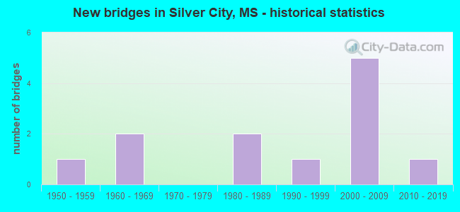
- New bridges - historical statistics
- 11950-1959
- 21960-1969
- 21980-1989
- 11990-1999
- 52000-2009
- 12010-2019


- Bridge Condition - Deck
- 60.0%Good
- 40.0%Satisfactory

- Bridge Condition - Superstructure
- 50.0%Very good
- 30.0%Good
- 20.0%Satisfactory

- Bridge Condition - Substructure
- 40.0%Very good
- 40.0%Good
- 20.0%Satisfactory

- Bridge Condition - Channel
- 50.0%Very good
- 8.3%Good
- 33.3%Satisfactory
- 8.3%Fair

- Bridge Condition - Culverts
- 50.0%Very good
- 50.0%Satisfactory
Find on map >> Show street view
Structure Number: 21000494272169, Location: 5.6 MI N YAZOO CL (Lat: 33.050261, Lng: -90.467531), Route carried "on" structure: US 49W, Year Built: 2004, Status: Open, Structure Length: 0.69m (2.26ft), Average Daily Traffic: 5,300 (year 2020), Truck Traffic: 22%, Average Future Daily Traffic: 6,800 (year 2040), Design Load: HS 20, Features Intersected: FRENCH BAYOU
Minimum Vertical Clearance: 30+ m (98+ ft), Kilometerpoint: 9.286, Lanes on structure: 4, Base Highway Network: Yes (Inventory Route: 49, Subroute: 1), Owner: State Highway Agency, Approaching Roadway Width: 25.2m (82.7ft), Skew: 1 degrees, Material/Design: Concrete, Design/Construction: Culvert, Number Of Spans In Main Unit: 2, Length of Maximum Span: 3.0m (9.8ft)
Condition: Channel: Very good, Culverts: Satisfactory, Operating Rating: 61.3 metric tons, Method Used To Determine Operating Rating: Load Factor (LF), Inventory Rating: 36.7 metric tons, Method Used To Determine Inventory Rating: Load Factor (LF), Structural Evaluation: Equal to present minimum criteria, Waterway Adequacy: Equal to present desirable criteria, Approach Roadway Alignment: Equal to present desirable criteria, Designated Inspection Frequency: Every 24 months, Underwater Inspection Frequency: Every 60 months, Inspection Date: January 2022
Find on map >> Show street view
Structure Number: 21000494272171A, Location: 5.8 MI N YAZOO CL (Lat: 33.055500, Lng: -90.469403), Route carried "on" structure: US 49W, Year Built: 2004, Status: Open, Structure Length: 36.65m (120.24ft), Average Daily Traffic: 2,650 (year 2020), Truck Traffic: 22%, Average Future Daily Traffic: 3,400 (year 2040), Design Load: HS 20, Features Intersected: LOWER AUXILIARY CHANNEL
Minimum Vertical Clearance: 30+ m (98+ ft), Kilometerpoint: 26.871, Lanes on structure: 2, Base Highway Network: Yes (Inventory Route: 49, Subroute: 2), Owner: State Highway Agency, Approaching Roadway Width: 12.0m (39.4ft), Skew: 10 degrees, Material/Design: Prestressed concrete, Design/Construction: Stringer/Multi-beam, Number Of Spans In Main Unit: 1, Number Of Approach Spans: 22, Length of Maximum Span: 30.0m (98.4ft), Curb or Sidewalk Widths: Left: 0.2m (0.7ft), Right: 0.2m (0.7ft), Curb-To-Curb Width: 12.0m (39.4ft), Out-to-Out Width: 12.9m (42.3ft)
Condition: Deck: Satisfactory, Superstructure: Very good, Substructure: Very good, Channel: Very good, Operating Rating: 65.3 metric tons, Method Used To Determine Operating Rating: Load Factor (LF), Inventory Rating: 32.5 metric tons, Method Used To Determine Inventory Rating: Load Factor (LF), Structural Evaluation: Equal to present desirable criteria, Deck Geometry: Better than present minimum criteria, Waterway Adequacy: Equal to present desirable criteria, Approach Roadway Alignment: Equal to present desirable criteria, Designated Inspection Frequency: Every 24 months, Underwater Inspection Frequency: Every 60 months, Inspection Date: May 2021, Deck Structure Type: Concrete Cast-file-Place
Find on map >> Show street view
Structure Number: 21000494272171B, Location: 5.8 MI N YAZOO CL (Lat: 33.052372, Lng: -90.468100), Route carried "on" structure: US 49W, Year Built: 2004, Status: Open, Structure Length: 36.65m (120.24ft), Average Daily Traffic: 2,650 (year 2020), Truck Traffic: 22%, Average Future Daily Traffic: 3,400 (year 2040), Design Load: HS 20, Features Intersected: LOWER AUXILIARY CHANNEL
Minimum Vertical Clearance: 30+ m (98+ ft), Kilometerpoint: 9.527, Lanes on structure: 2, Base Highway Network: Yes (Inventory Route: 49, Subroute: 1), Owner: State Highway Agency, Approaching Roadway Width: 12.0m (39.4ft), Skew: 10 degrees, Material/Design: Prestressed concrete, Design/Construction: Stringer/Multi-beam, Number Of Spans In Main Unit: 1, Number Of Approach Spans: 21, Length of Maximum Span: 34.0m (111.5ft), Curb or Sidewalk Widths: Left: 0.2m (0.7ft), Right: 0.2m (0.7ft), Curb-To-Curb Width: 12.0m (39.4ft), Out-to-Out Width: 12.9m (42.3ft)
Condition: Deck: Good, Superstructure: Good, Substructure: Good, Channel: Very good, Operating Rating: 65.3 metric tons, Method Used To Determine Operating Rating: Load Factor (LF), Inventory Rating: 32.5 metric tons, Method Used To Determine Inventory Rating: Load Factor (LF), Structural Evaluation: Better than present minimum criteria, Deck Geometry: Better than present minimum criteria, Waterway Adequacy: Equal to present desirable criteria, Approach Roadway Alignment: Equal to present desirable criteria, Designated Inspection Frequency: Every 24 months, Underwater Inspection Frequency: Every 60 months, Inspection Date: May 2021, Deck Structure Type: Concrete Cast-file-Place
Find on map >> Show street view
Structure Number: 21000494272187A, Location: 7.4 MI N YAZOO CL (Lat: 33.076917, Lng: -90.478828), Route carried "on" structure: US 49W, Year Built: 2004, Status: Open, Structure Length: 14.45m (47.41ft), Average Daily Traffic: 2,650 (year 2020), Truck Traffic: 22%, Average Future Daily Traffic: 3,400 (year 2040), Design Load: HS 20, Features Intersected: ATCHAFALAYA BAYOU
Minimum Vertical Clearance: 30+ m (98+ ft), Kilometerpoint: 24.311, Lanes on structure: 2, Base Highway Network: Yes (Inventory Route: 49, Subroute: 2), Owner: State Highway Agency, Approaching Roadway Width: 12.0m (39.4ft), Skew: 10 degrees, Material/Design: Prestressed concrete continuous, Design/Construction: Stringer/Multi-beam, Number Of Spans In Main Unit: 3, Number Of Approach Spans: 6, Length of Maximum Span: 24.0m (78.7ft), Curb-To-Curb Width: 12.0m (39.4ft), Out-to-Out Width: 12.9m (42.3ft)
Condition: Deck: Satisfactory, Superstructure: Very good, Substructure: Good, Channel: Very good, Operating Rating: 60.8 metric tons, Method Used To Determine Operating Rating: Load Factor (LF), Inventory Rating: 36.4 metric tons, Method Used To Determine Inventory Rating: Load Factor (LF), Structural Evaluation: Better than present minimum criteria, Deck Geometry: Better than present minimum criteria, Waterway Adequacy: Equal to present desirable criteria, Approach Roadway Alignment: Equal to present desirable criteria, Designated Inspection Frequency: Every 24 months, Inspection Date: January 2021, Deck Structure Type: Concrete Cast-file-Place
Find on map >> Show street view
Structure Number: 21000494272187B, Location: 7.4 MI N YAZOO CL (Lat: 33.076014, Lng: -90.477608), Route carried "on" structure: US 49W, Year Built: 2004, Status: Open, Structure Length: 14.45m (47.41ft), Average Daily Traffic: 2,650 (year 2020), Truck Traffic: 22%, Average Future Daily Traffic: 3,400 (year 2040), Design Load: HS 20, Features Intersected: ATCHAFALAYA BAYOU
Minimum Vertical Clearance: 30+ m (98+ ft), Kilometerpoint: 12.315, Lanes on structure: 2, Base Highway Network: Yes (Inventory Route: 49, Subroute: 1), Owner: State Highway Agency, Approaching Roadway Width: 12.0m (39.4ft), Skew: 10 degrees, Material/Design: Prestressed concrete continuous, Design/Construction: Stringer/Multi-beam, Number Of Spans In Main Unit: 3, Number Of Approach Spans: 6, Length of Maximum Span: 24.0m (78.7ft), Curb or Sidewalk Widths: Left: 0.2m (0.7ft), Right: 0.2m (0.7ft), Curb-To-Curb Width: 12.0m (39.4ft), Out-to-Out Width: 12.9m (42.3ft)
Condition: Deck: Good, Superstructure: Very good, Substructure: Good, Channel: Very good, Operating Rating: 60.8 metric tons, Method Used To Determine Operating Rating: Load Factor (LF), Inventory Rating: 36.4 metric tons, Method Used To Determine Inventory Rating: Load Factor (LF), Structural Evaluation: Better than present minimum criteria, Deck Geometry: Better than present minimum criteria, Waterway Adequacy: Equal to present desirable criteria, Approach Roadway Alignment: Equal to present desirable criteria, Designated Inspection Frequency: Every 24 months, Inspection Date: January 2021, Deck Structure Type: Concrete Cast-file-Place
Find on map >> Show street view
Structure Number: SA2700000000019, Location: SEC 6 T14N R 3W (Lat: 33.085797, Lng: -90.537781), Route carried "on" structure: County highway 146, Year Built: 1997, Status: Open, Structure Length: 2.32m (7.61ft), Average Daily Traffic: 30 (year 2018), Average Future Daily Traffic: 45 (year 2038), Design Load: HS 20, Features Intersected: DRAINAGE DITCH, Facility Carried by Structure: AYCOCK ROAD
Minimum Vertical Clearance: 30+ m (98+ ft), Kilometerpoint: 1.126, Lanes on structure: 2, Owner: County Highway Agency, Approaching Roadway Width: 7.3m (24.0ft), Material/Design: Concrete, Design/Construction: Channel Beam, Number Of Spans In Main Unit: 4, Length of Maximum Span: 5.8m (19.0ft), Curb or Sidewalk Widths: Left: 0.5m (1.6ft), Right: 0.5m (1.6ft), Curb-To-Curb Width: 8.5m (27.9ft), Out-to-Out Width: 9.5m (31.2ft)
Condition: Deck: Good, Superstructure: Very good, Substructure: Very good, Channel: Very good, Operating Rating: 89.2 metric tons, Method Used To Determine Operating Rating: Load Factor (LF), Inventory Rating: 53.6 metric tons, Method Used To Determine Inventory Rating: Load Factor (LF), Structural Evaluation: Equal to present desirable criteria, Deck Geometry: Better than present minimum criteria, Waterway Adequacy: Equal to present desirable criteria, Approach Roadway Alignment: Equal to present desirable criteria, Designated Inspection Frequency: Every 24 months, Inspection Date: October 2020, Deck Structure Type: Concrete Precast Panels, Wearing Surface/Protective System: Wearing Surface: Monolithic Concrete
Find on map >> Show street view
Structure Number: SA2700000000022, Location: SEC 23 T14N R 3W B (Lat: 33.046044, Lng: -90.477608), Route carried "on" structure: County highway 509, Year Built: 1959, Status: Posted for load, Structure Length: 14.03m (46.03ft), Average Daily Traffic: 110 (year 2015), Truck Traffic: 10%, Average Future Daily Traffic: 165 (year 2035), Design Load: HS 20, Features Intersected: 509 OVER LOWER AUXI CHAN, Facility Carried by Structure: LAMKIN ROAD
Minimum Vertical Clearance: 30+ m (98+ ft), Kilometerpoint: 8.046, Lanes on structure: 2, Owner: County Highway Agency, Approaching Roadway Width: 7.3m (24.0ft), Material/Design: Steel continuous, Design/Construction: Stringer/Multi-beam, Number Of Spans In Main Unit: 3, Number Of Approach Spans: 4, Length of Maximum Span: 42.7m (140.1ft), Curb or Sidewalk Widths: Left: 0.5m (1.6ft), Right: 0.5m (1.6ft), Curb-To-Curb Width: 7.3m (24.0ft), Out-to-Out Width: 8.3m (27.2ft)
Condition: Deck: Satisfactory, Superstructure: Satisfactory, Substructure: Satisfactory, Channel: Satisfactory, Operating Rating: 32.1 metric tons, Method Used To Determine Operating Rating: Load Factor (LF) rating reported by rating factor (RF) method using MS18 loading, Inventory Rating: 19.1 metric tons, Method Used To Determine Inventory Rating: Load Factor (LF) rating reported by rating factor (RF) method using MS18 loading, Structural Evaluation: Somewhat better than minimum adequacy, Deck Geometry: Somewhat better than minimum adequacy, Waterway Adequacy: Equal to present desirable criteria, Approach Roadway Alignment: Equal to present desirable criteria, Bridge Posting: Required (Relationship of Operating Rating to Maximum Legal Load: 0.1 - 9.9% below), Length Of Structure Improvement: 15.24m (50.00ft), Designated Inspection Frequency: Every 24 months, Inspection Date: November 2021, Bridge Improvement Cost: $910,000, Roadway Improvement Cost: $91,000, Total Project Cost: $1,121,000 ( Estimate for 2016), Deck Structure Type: Concrete Cast-file-Place
Find on map >> Show street view
Structure Number: SA2700000000023, Location: SEC 23 T14N R 3W B (Lat: 33.046403, Lng: -90.480356), Route carried "on" structure: County highway 509, Year Built: 1962, Status: Posted for load-capacity, Structure Length: 1.83m (6.00ft), Average Daily Traffic: 110 (year 2018), Truck Traffic: 8%, Average Future Daily Traffic: 135 (year 2038), Design Load: H 15, Features Intersected: 509 OVER WEST DITCH LAC, Facility Carried by Structure: LAMKIN ROAD
Minimum Vertical Clearance: 30+ m (98+ ft), Kilometerpoint: 8.207, Lanes on structure: 2, Owner: County Highway Agency, Approaching Roadway Width: 6.4m (21.0ft), Material/Design: Concrete, Design/Construction: Slab, Number Of Spans In Main Unit: 3, Length of Maximum Span: 6.1m (20.0ft), Curb or Sidewalk Widths: Left: 0.5m (1.6ft), Right: 0.5m (1.6ft), Curb-To-Curb Width: 7.3m (24.0ft), Out-to-Out Width: 8.3m (27.2ft)
Condition: Deck: Good, Superstructure: Good, Substructure: Very good, Channel: Satisfactory, Operating Rating: 43.2 metric tons, Method Used To Determine Operating Rating: Load Factor (LF), Inventory Rating: 25.8 metric tons, Method Used To Determine Inventory Rating: Load Factor (LF), Structural Evaluation: Equal to present minimum criteria, Deck Geometry: Somewhat better than minimum adequacy, Waterway Adequacy: Equal to present desirable criteria, Approach Roadway Alignment: Equal to present desirable criteria, Length Of Structure Improvement: 2.83m (9.28ft), Designated Inspection Frequency: Every 24 months, Inspection Date: October 2020, Bridge Improvement Cost: $169,000, Roadway Improvement Cost: $17,000, Total Project Cost: $208,000 ( Estimate for 2018), Deck Structure Type: Concrete Cast-file-Place, Wearing Surface/Protective System: Wearing Surface: Bituminous
Find on map >> Show street view
Structure Number: SA2700000000029, Location: SEC 1 T14N R 4W B (Lat: 33.084778, Lng: -90.554786), Route carried "on" structure: County highway 82, Year Built: 1985, Status: Open, Structure Length: 1.74m (5.71ft), Average Daily Traffic: 60 (year 2018), Average Future Daily Traffic: 90 (year 2038), Design Load: HS 20, Features Intersected: DRAINAGE CANAL, Facility Carried by Structure: BEAT LINE ROAD
Minimum Vertical Clearance: 30+ m (98+ ft), Kilometerpoint: 5.149, Lanes on structure: 2, Owner: County Highway Agency, Approaching Roadway Width: 6.1m (20.0ft), Material/Design: Concrete, Design/Construction: Slab, Number Of Spans In Main Unit: 3, Length of Maximum Span: 5.8m (19.0ft), Curb or Sidewalk Widths: Left: 0.4m (1.3ft), Right: 0.4m (1.3ft), Curb-To-Curb Width: 8.5m (27.9ft), Out-to-Out Width: 9.3m (30.5ft)
Condition: Deck: Good, Superstructure: Very good, Substructure: Very good, Channel: Fair, Operating Rating: 70.9 metric tons, Method Used To Determine Operating Rating: Load Factor (LF), Inventory Rating: 42.5 metric tons, Method Used To Determine Inventory Rating: Load Factor (LF), Structural Evaluation: Equal to present desirable criteria, Deck Geometry: Better than present minimum criteria, Waterway Adequacy: Equal to present desirable criteria, Approach Roadway Alignment: Equal to present desirable criteria, Designated Inspection Frequency: Every 24 months, Inspection Date: October 2020, Deck Structure Type: Concrete Cast-file-Place, Wearing Surface/Protective System: Wearing Surface: Monolithic Concrete
Find on map >> Show street view
Structure Number: SA2700000000073, Location: SEC 36 T15N R 4W B (Lat: 33.101903, Lng: -90.554917), Route carried "on" structure: County highway 82, Year Built: 1985, Status: Open, Structure Length: 1.74m (5.71ft), Average Daily Traffic: 60 (year 2018), Average Future Daily Traffic: 90 (year 2038), Design Load: HS 20, Features Intersected: DRAINAGE DITCH, Facility Carried by Structure: BEAT LINE ROAD
Minimum Vertical Clearance: 30+ m (98+ ft), Kilometerpoint: 7.242, Lanes on structure: 2, Owner: County Highway Agency, Approaching Roadway Width: 5.8m (19.0ft), Material/Design: Concrete, Design/Construction: Slab, Number Of Spans In Main Unit: 3, Length of Maximum Span: 5.8m (19.0ft), Curb or Sidewalk Widths: Left: 0.4m (1.3ft), Right: 0.4m (1.3ft), Curb-To-Curb Width: 8.5m (27.9ft), Out-to-Out Width: 9.3m (30.5ft)
Condition: Deck: Good, Superstructure: Good, Substructure: Good, Channel: Satisfactory, Operating Rating: 70.9 metric tons, Method Used To Determine Operating Rating: Load Factor (LF), Inventory Rating: 42.5 metric tons, Method Used To Determine Inventory Rating: Load Factor (LF), Structural Evaluation: Better than present minimum criteria, Deck Geometry: Better than present minimum criteria, Waterway Adequacy: Equal to present desirable criteria, Approach Roadway Alignment: Equal to present desirable criteria, Designated Inspection Frequency: Every 24 months, Inspection Date: November 2021, Deck Structure Type: Concrete Cast-file-Place
Find on map >> Show street view
Structure Number: SA2700000000104, Location: SEC 23 T14N R 3W B (Lat: 33.045650, Lng: -90.474725), Route carried "on" structure: County highway 15, Year Built: 1968, Status: Posted for load, Structure Length: 2.89m (9.48ft), Average Daily Traffic: 110 (year 2021), Truck Traffic: 8%, Average Future Daily Traffic: 165 (year 2043), Design Load: H 15, Features Intersected: LITTLE KILBY CREEK, Facility Carried by Structure: LAMKIN ROAD
Minimum Vertical Clearance: 30+ m (98+ ft), Kilometerpoint: 0.259, Lanes on structure: 2, Owner: County Highway Agency, Approaching Roadway Width: 6.7m (22.0ft), Material/Design: Concrete, Design/Construction: Channel Beam, Number Of Spans In Main Unit: 5, Length of Maximum Span: 5.8m (19.0ft), Curb or Sidewalk Widths: Left: 0.2m (0.7ft), Right: 0.2m (0.7ft), Curb-To-Curb Width: 7.1m (23.3ft), Out-to-Out Width: 7.5m (24.6ft)
Condition: Deck: Satisfactory, Superstructure: Satisfactory, Substructure: Satisfactory, Channel: Satisfactory, Operating Rating: 51.8 metric tons, Method Used To Determine Operating Rating: Load Factor (LF), Inventory Rating: 31.7 metric tons, Method Used To Determine Inventory Rating: Load Factor (LF), Structural Evaluation: Equal to present minimum criteria, Deck Geometry: Meets minimum limits, Waterway Adequacy: Better than present minimum criteria, Approach Roadway Alignment: Equal to present desirable criteria, Length Of Structure Improvement: 3.65m (11.98ft), Designated Inspection Frequency: Every 12 months, Inspection Date: September 2021, Bridge Improvement Cost: $218,000, Roadway Improvement Cost: $22,000, Total Project Cost: $269,000 ( Estimate for 2016), Deck Structure Type: Concrete Precast Panels, Wearing Surface/Protective System: Wearing Surface: Monolithic Concrete
Find on map >> Show street view
Structure Number: SA270000000A054, Location: SEC 33 T15N R 3W (Lat: 33.094853, Lng: -90.525589), Route carried "on" structure: County highway 148, Year Built: 2018, Status: Open, Structure Length: 0.77m (2.53ft), Average Daily Traffic: 5 (year 2018), Average Future Daily Traffic: 8 (year 2038), Design Load: HS 20, Features Intersected: DRAINAGE DITCH, Facility Carried by Structure: PEACH TREE ROAD
Minimum Vertical Clearance: 30+ m (98+ ft), Kilometerpoint: 2.735, Lanes on structure: 2, Owner: County Highway Agency, Approaching Roadway Width: 4.9m (16.1ft), Skew: 4 degrees, Material/Design: Concrete, Design/Construction: Culvert, Number Of Spans In Main Unit: 1, Length of Maximum Span: 4.9m (16.1ft)
Condition: Channel: Good, Culverts: Very good, Operating Rating: 63.6 metric tons, Method Used To Determine Operating Rating: Load Factor (LF), Inventory Rating: 38.1 metric tons, Method Used To Determine Inventory Rating: Load Factor (LF), Structural Evaluation: Equal to present desirable criteria, Waterway Adequacy: Equal to present desirable criteria, Approach Roadway Alignment: Equal to present desirable criteria, Designated Inspection Frequency: Every 24 months, Inspection Date: November 2021