Bridge Statistics for Sigel, Illinois (IL)
Condition, Traffic, Stress, Structural Evaluation, Project Costs
- National Bridge Inventory (NBI) Statistics
- 20Number of bridges
- 154ft / 47.1mTotal length
- $901,000Total costs
- 61,650Total average daily traffic
- 23,489Total average daily truck traffic
- National Bridge Inventory (NBI) Registered Bridges for Sigel
- No street view available for this location
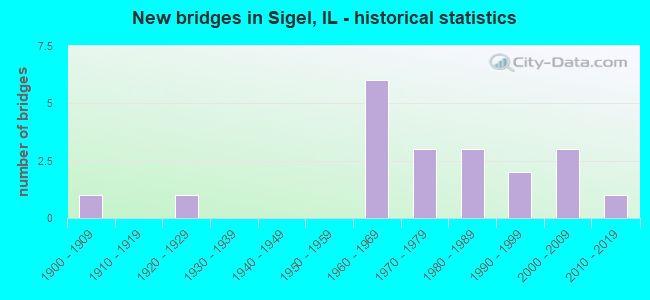
- New bridges - historical statistics
- 11900-1909
- 11920-1929
- 61960-1969
- 31970-1979
- 31980-1989
- 21990-1999
- 32000-2009
- 12010-2019


- Bridge Condition - Deck
- 23.5%Very good
- 35.3%Good
- 17.6%Satisfactory
- 11.8%Poor
- 11.8%Failed

- Bridge Condition - Superstructure
- 23.5%Very good
- 35.3%Good
- 11.8%Satisfactory
- 11.8%Fair
- 5.9%Poor
- 11.8%Failed

- Bridge Condition - Substructure
- 47.1%Very good
- 11.8%Good
- 23.5%Satisfactory
- 5.9%Poor
- 11.8%Failed

- Bridge Condition - Channel
- 18.8%Excellent
- 18.8%Very good
- 18.8%Good
- 18.8%Satisfactory
- 18.8%Fair
- 6.3%Serious
Find on map >> Show street view
Structure Number: 250003, Location: 1.5 MI S SHELBY C L (Lat: 39.194117, Lng: -88.502242), Route carried "on" structure: Interstate 57, Year Built: 1964, Year Reconstructed: 1994, Status: Open, Structure Length: 4.69m (15.39ft), Average Daily Traffic: 9,700 (year 2021), Truck Traffic: 40%, Average Future Daily Traffic: 9,050 (year 2032), Design Load: HS 20+Mod, Features Intersected: GREEN CREEK
Minimum Vertical Clearance: 30+ m (98+ ft), Kilometerpoint: 268.142, Lanes on structure: 2, Base Highway Network: Yes, Owner: State Highway Agency, Approaching Roadway Width: 12.2m (40.0ft), Skew: 1 degrees, Material/Design: Steel continuous, Design/Construction: Stringer/Multi-beam, Number Of Spans In Main Unit: 3, Length of Maximum Span: 16.8m (55.1ft), Curb-To-Curb Width: 12.2m (40.0ft), Out-to-Out Width: 12.9m (42.3ft)
Condition: Deck: Poor, Superstructure: Fair, Substructure: Satisfactory, Channel: Fair, Operating Rating: 53.1 metric tons, Method Used To Determine Operating Rating: Load Factor (LF) rating reported by rating factor (RF) method using MS18 loading, Inventory Rating: 32.4 metric tons, Method Used To Determine Inventory Rating: Load Factor (LF) rating reported by rating factor (RF) method using MS18 loading, Structural Evaluation: Somewhat better than minimum adequacy, Deck Geometry: Better than present minimum criteria, Waterway Adequacy: Equal to present desirable criteria, Approach Roadway Alignment: Equal to present desirable criteria, Designated Inspection Frequency: Every 24 months, Inspection Date: August 2021, Deck Structure Type: Concrete Cast-file-Place, Wearing Surface/Protective System: Wearing Surface: Bituminous, Membrane: Built-up
Find on map >> Show street view
Structure Number: 250004, Location: 1.5 MI S SHELBY C L (Lat: 39.194253, Lng: -88.502186), Route carried "on" structure: Interstate 57, Year Built: 1964, Status: Open, Structure Length: 4.69m (15.39ft), Average Daily Traffic: 9,700 (year 2021), Truck Traffic: 40%, Average Future Daily Traffic: 11,500 (year 2032), Design Load: HS 20+Mod, Features Intersected: GREEN CREEK
Minimum Vertical Clearance: 30+ m (98+ ft), Kilometerpoint: 268.158, Lanes on structure: 2, Base Highway Network: Yes, Owner: State Highway Agency, Approaching Roadway Width: 12.2m (40.0ft), Skew: 1 degrees, Material/Design: Steel continuous, Design/Construction: Stringer/Multi-beam, Number Of Spans In Main Unit: 3, Length of Maximum Span: 16.8m (55.1ft), Curb-To-Curb Width: 11.6m (38.1ft), Out-to-Out Width: 12.7m (41.7ft)
Condition: Deck: Satisfactory, Superstructure: Fair, Substructure: Satisfactory, Channel: Good, Operating Rating: 53.5 metric tons, Method Used To Determine Operating Rating: Load Factor (LF) rating reported by rating factor (RF) method using MS18 loading, Inventory Rating: 32.4 metric tons, Method Used To Determine Inventory Rating: Load Factor (LF) rating reported by rating factor (RF) method using MS18 loading, Structural Evaluation: Somewhat better than minimum adequacy, Deck Geometry: Equal to present minimum criteria, Waterway Adequacy: Equal to present desirable criteria, Approach Roadway Alignment: Equal to present desirable criteria, Designated Inspection Frequency: Every 24 months, Inspection Date: October 2020, Deck Structure Type: Concrete Cast-file-Place, Wearing Surface/Protective System: Wearing Surface: Other
Find on map >> Show street view
Structure Number: 250063, Location: .6 MI S SHELBY CO LN (Lat: 39.207131, Lng: -88.493750), Route carried "on" structure: County highway , Year Built: 1964, Status: Open, Structure Length: 7.62m (25.00ft), Average Daily Traffic: 400 (year 2018), Truck Traffic: 1%, Average Future Daily Traffic: 402 (year 2032), Design Load: HS 15, Features Intersected: FAI-57, Facility Carried by Structure: TR-264
Minimum Vertical Clearance: 30+ m (98+ ft), Kilometerpoint: 0.837, Lanes on structure: 2, Lanes under structure: 4, Owner: State Highway Agency, Approaching Roadway Width: 5.5m (18.0ft), Skew: 2 degrees, Material/Design: Steel continuous, Design/Construction: Stringer/Multi-beam, Number Of Spans In Main Unit: 4, Length of Maximum Span: 23.2m (76.1ft), Curb or Sidewalk Widths: Left: 0.6m (2.0ft), Right: 0.6m (2.0ft), Curb-To-Curb Width: 7.3m (24.0ft), Out-to-Out Width: 9.1m (29.9ft)
Condition: Deck: Good, Superstructure: Good, Substructure: Good, Operating Rating: 45.7 metric tons, Method Used To Determine Operating Rating: Allowable Stress (AS) rating reported by rating factor (RF) method using MS18 loading, Inventory Rating: 29.5 metric tons, Method Used To Determine Inventory Rating: Allowable Stress (AS) rating reported by rating factor (RF) method using MS18 loading, Structural Evaluation: Better than present minimum criteria, Deck Geometry: Somewhat better than minimum adequacy, Underclear: High priority of corrective action, Approach Roadway Alignment: Equal to present minimum criteria, Length Of Structure Improvement: 7.62m (25.00ft), Designated Inspection Frequency: Every 24 months, Inspection Date: Febuary 2021, Bridge Improvement Cost: $179,000, Roadway Improvement Cost: $18,000, Total Project Cost: $215,000, Deck Structure Type: Concrete Cast-file-Place
Find on map >> Show street view
Structure Number: 253155, Location: 4 MI NE EFFINGHAM (Lat: 39.197842, Lng: -88.494175), Route carried "on" structure: County highway , Year Built: 1976, Status: Open, Structure Length: 1.74m (5.71ft), Average Daily Traffic: 375 (year 2018), Truck Traffic: 1%, Average Future Daily Traffic: 375 (year 2032), Features Intersected: E BR GREEN CREEK, Facility Carried by Structure: TR-264
Minimum Vertical Clearance: 30+ m (98+ ft), Kilometerpoint: 1.947, Lanes on structure: 2, Owner: Town or Township Highway Agency, Approaching Roadway Width: 7.3m (24.0ft), Material/Design: Steel, Design/Construction: Girder and Floorbeam System, Number Of Spans In Main Unit: 1, Length of Maximum Span: 16.5m (54.1ft), Curb-To-Curb Width: 7.0m (23.0ft), Out-to-Out Width: 7.6m (24.9ft)
Condition: Deck: Good, Superstructure: Good, Substructure: Good, Channel: Good, Operating Rating: 35.3 metric tons, Method Used To Determine Operating Rating: Allowable Stress (AS) rating reported by rating factor (RF) method using MS18 loading, Inventory Rating: 24.9 metric tons, Method Used To Determine Inventory Rating: Allowable Stress (AS) rating reported by rating factor (RF) method using MS18 loading, Structural Evaluation: Equal to present minimum criteria, Deck Geometry: Meets minimum limits, Waterway Adequacy: Equal to present desirable criteria, Approach Roadway Alignment: Equal to present minimum criteria, Designated Inspection Frequency: Every 24 months, Critical Feature Inspection Frequency: Every 24 months, Inspection Date: November 2020, Critical Feature Inspection Date: November 2020, Deck Structure Type: Concrete Cast-file-Place, Wearing Surface/Protective System: Wearing Surface: Gravel
Find on map >> Show street view
Structure Number: 253157, Location: 4.5 MI NE EFFINGHAM (Lat: 39.200550, Lng: -88.485244), Route carried "on" structure: County highway , Year Built: 1978, Status: Open, Structure Length: 1.49m (4.89ft), Average Daily Traffic: 150 (year 2018), Truck Traffic: 1%, Average Future Daily Traffic: 80 (year 2032), Design Load: HS 20, Features Intersected: E BR GREEN CREEK, Facility Carried by Structure: TR-11
Minimum Vertical Clearance: 30+ m (98+ ft), Kilometerpoint: 0.772, Lanes on structure: 2, Owner: Town or Township Highway Agency, Approaching Roadway Width: 6.1m (20.0ft), Skew: 1 degrees, Material/Design: Prestressed concrete, Design/Construction: Box Beam or Girders - Multiple, Number Of Spans In Main Unit: 1, Length of Maximum Span: 14.0m (45.9ft), Curb-To-Curb Width: 7.4m (24.3ft), Out-to-Out Width: 7.4m (24.3ft)
Condition: Deck: Good, Superstructure: Good, Substructure: Very good, Channel: Very good, Operating Rating: 44.4 metric tons, Method Used To Determine Operating Rating: Assigned rating based on Load Factor Design (LFD) reported by rating factor (RF) using MS18 loading, Inventory Rating: 32.4 metric tons, Method Used To Determine Inventory Rating: Assigned rating based on Load Factor Design (LFD) reported by rating factor (RF) using MS18 loading, Structural Evaluation: Better than present minimum criteria, Deck Geometry: Somewhat better than minimum adequacy, Waterway Adequacy: Equal to present desirable criteria, Approach Roadway Alignment: Equal to present desirable criteria, Designated Inspection Frequency: Every 48 months, Inspection Date: January 2021, Deck Structure Type: Concrete Precast Panels, Wearing Surface/Protective System: Wearing Surface: Gravel
Find on map >> Show street view
Structure Number: 253159, Location: 1 MI N ST MARY'S (Lat: 39.215064, Lng: -88.525908), Route carried "on" structure: County highway , Year Built: 1981, Status: Open, Structure Length: 2.19m (7.19ft), Average Daily Traffic: 75 (year 2018), Truck Traffic: 3%, Average Future Daily Traffic: 54 (year 2032), Design Load: HS 20, Features Intersected: HENRY CREEK, Facility Carried by Structure: TR-3
Minimum Vertical Clearance: 30+ m (98+ ft), Kilometerpoint: 3.315, Lanes on structure: 2, Owner: Town or Township Highway Agency, Approaching Roadway Width: 5.5m (18.0ft), Material/Design: Prestressed concrete, Design/Construction: Box Beam or Girders - Multiple, Number Of Spans In Main Unit: 1, Length of Maximum Span: 21.3m (69.9ft), Curb-To-Curb Width: 7.4m (24.3ft), Out-to-Out Width: 7.4m (24.3ft)
Condition: Deck: Good, Superstructure: Good, Substructure: Very good, Channel: Satisfactory, Operating Rating: 44.4 metric tons, Method Used To Determine Operating Rating: Assigned rating based on Load Factor Design (LFD) reported by rating factor (RF) using MS18 loading, Inventory Rating: 32.4 metric tons, Method Used To Determine Inventory Rating: Assigned rating based on Load Factor Design (LFD) reported by rating factor (RF) using MS18 loading, Structural Evaluation: Better than present minimum criteria, Deck Geometry: Equal to present minimum criteria, Waterway Adequacy: Equal to present desirable criteria, Approach Roadway Alignment: Equal to present minimum criteria, Designated Inspection Frequency: Every 48 months, Inspection Date: January 2021, Deck Structure Type: Concrete Precast Panels, Wearing Surface/Protective System: Wearing Surface: Gravel
Find on map >> Show street view
Structure Number: 253163, Location: 2 MI NW ST MARY'S (Lat: 39.215161, Lng: -88.540739), Route carried "on" structure: County highway , Year Built: 1984, Status: Open, Structure Length: 2.47m (8.10ft), Average Daily Traffic: 75 (year 2018), Truck Traffic: 3%, Average Future Daily Traffic: 54 (year 2032), Design Load: HS 20, Features Intersected: GREEN CREEK, Facility Carried by Structure: TR-3
Minimum Vertical Clearance: 30+ m (98+ ft), Kilometerpoint: 2.028, Lanes on structure: 2, Owner: Town or Township Highway Agency, Approaching Roadway Width: 7.3m (24.0ft), Material/Design: Prestressed concrete, Design/Construction: Box Beam or Girders - Multiple, Number Of Spans In Main Unit: 2, Length of Maximum Span: 11.4m (37.4ft), Curb-To-Curb Width: 7.3m (24.0ft), Out-to-Out Width: 7.3m (24.0ft)
Condition: Deck: Good, Superstructure: Good, Substructure: Very good, Channel: Very good, Operating Rating: 44.4 metric tons, Method Used To Determine Operating Rating: Load Factor (LF) rating reported by rating factor (RF) method using MS18 loading, Inventory Rating: 32.4 metric tons, Method Used To Determine Inventory Rating: Load Factor (LF) rating reported by rating factor (RF) method using MS18 loading, Structural Evaluation: Better than present minimum criteria, Deck Geometry: Equal to present minimum criteria, Waterway Adequacy: Equal to present desirable criteria, Approach Roadway Alignment: Equal to present desirable criteria, Length Of Structure Improvement: 2.47m (8.10ft), Designated Inspection Frequency: Every 48 months, Inspection Date: January 2021, Bridge Improvement Cost: $280,000, Roadway Improvement Cost: $70,000, Total Project Cost: $350,000, Deck Structure Type: Concrete Precast Panels, Wearing Surface/Protective System: Wearing Surface: Gravel
Find on map >> Show street view
Structure Number: 87001, Location: 1 MI N EFF CO LINE (Lat: 39.229550, Lng: -88.483281), Route carried "on" structure: County highway , Year Built: 1964, Status: Open, Structure Length: 6.82m (22.38ft), Average Daily Traffic: 650 (year 2018), Truck Traffic: 12%, Average Future Daily Traffic: 987 (year 2032), Design Load: HS 15, Features Intersected: I-57, Facility Carried by Structure: FAS 1656(CH 23)
Minimum Vertical Clearance: 30+ m (98+ ft), Kilometerpoint: 0.933, Lanes on structure: 2, Lanes under structure: 4, Owner: State Highway Agency, Approaching Roadway Width: 6.7m (22.0ft), Material/Design: Prestressed concrete continuous, Design/Construction: Stringer/Multi-beam, Number Of Spans In Main Unit: 4, Length of Maximum Span: 20.7m (67.9ft), Curb or Sidewalk Widths: Left: 0.6m (2.0ft), Right: 0.6m (2.0ft), Curb-To-Curb Width: 7.9m (25.9ft), Out-to-Out Width: 9.7m (31.8ft)
Condition: Deck: Satisfactory, Superstructure: Satisfactory, Substructure: Satisfactory, Operating Rating: 72.9 metric tons, Method Used To Determine Operating Rating: Load Factor (LF) rating reported by rating factor (RF) method using MS18 loading, Inventory Rating: 45.0 metric tons, Method Used To Determine Inventory Rating: Load Factor (LF) rating reported by rating factor (RF) method using MS18 loading, Structural Evaluation: Equal to present minimum criteria, Deck Geometry: Somewhat better than minimum adequacy, Underclear: High priority of corrective action, Approach Roadway Alignment: Equal to present desirable criteria, Designated Inspection Frequency: Every 24 months, Inspection Date: June 2021, Deck Structure Type: Concrete Cast-file-Place
Find on map >> Show street view
Structure Number: 873021, Location: 3.5 MI NW SIGEL (Lat: 39.273275, Lng: -88.515219), Route carried "on" structure: County highway , Year Built: 1909, Status: Temporarily open, Structure Length: 0.68m (2.23ft), Average Daily Traffic: 200 (year 2018), Truck Traffic: 4%, Average Future Daily Traffic: 290 (year 2032), Features Intersected: GREEN CREEK, Facility Carried by Structure: TR 385
Minimum Vertical Clearance: 30+ m (98+ ft), Kilometerpoint: 9.012, Lanes on structure: 1, Owner: Town or Township Highway Agency, Approaching Roadway Width: 7.3m (24.0ft), Material/Design: Steel, Design/Construction: Stringer/Multi-beam, Number Of Spans In Main Unit: 1, Length of Maximum Span: 6.6m (21.7ft), Curb-To-Curb Width: 4.8m (15.7ft), Out-to-Out Width: 4.9m (16.1ft)
Condition: Deck: Failed, Superstructure: Failed, Substructure: Failed, Channel: Fair, Deck Geometry: High priority of corrective action, Waterway Adequacy: Better than present minimum criteria, Approach Roadway Alignment: Meets minimum limits, Length Of Structure Improvement: 0.67m (2.20ft), Designated Inspection Frequency: Every 24 months, Inspection Date: March 2020, Bridge Improvement Cost: $43,000, Roadway Improvement Cost: $7,000, Total Project Cost: $50,000, Deck Structure Type: Concrete Cast-file-Place, Wearing Surface/Protective System: Wearing Surface: Bituminous
Find on map >> Show street view
Structure Number: 873235, Location: 3.5 MI NW SIGEL (Lat: 39.273200, Lng: -88.500656), Route carried "on" structure: County highway , Year Built: 1979, Status: Temporarily open, Structure Length: 0.67m (2.20ft), Average Daily Traffic: 200 (year 2018), Truck Traffic: 4%, Average Future Daily Traffic: 290 (year 2032), Features Intersected: STREAM, Facility Carried by Structure: TR 385
Minimum Vertical Clearance: 30+ m (98+ ft), Kilometerpoint: 10.267, Lanes on structure: 1, Owner: Town or Township Highway Agency, Approaching Roadway Width: 7.3m (24.0ft), Material/Design: Steel, Design/Construction: Stringer/Multi-beam, Number Of Spans In Main Unit: 1, Length of Maximum Span: 6.6m (21.7ft), Curb-To-Curb Width: 4.8m (15.7ft), Out-to-Out Width: 5.0m (16.4ft)
Condition: Deck: Failed, Superstructure: Failed, Substructure: Failed, Channel: Fair, Deck Geometry: High priority of corrective action, Waterway Adequacy: Equal to present minimum criteria, Approach Roadway Alignment: Meets minimum limits, Length Of Structure Improvement: 0.67m (2.20ft), Designated Inspection Frequency: Every 24 months, Inspection Date: March 2020, Bridge Improvement Cost: $44,000, Roadway Improvement Cost: $7,000, Total Project Cost: $51,000, Deck Structure Type: Concrete Cast-file-Place, Wearing Surface/Protective System: Wearing Surface: Bituminous
Find on map >> Show street view
Structure Number: 873266, Location: 1 MI SE SIGEL (Lat: 39.218619, Lng: -88.474736), Route carried "on" structure: County highway , Year Built: 1920, Status: Posted for load, Structure Length: 0.91m (2.99ft), Average Daily Traffic: 50 (year 2018), Average Future Daily Traffic: 87 (year 2032), Features Intersected: STREAM, Facility Carried by Structure: TR 499 A
Minimum Vertical Clearance: 30+ m (98+ ft), Kilometerpoint: 0.724, Lanes on structure: 1, Owner: Town or Township Highway Agency, Approaching Roadway Width: 6.1m (20.0ft), Material/Design: Concrete, Design/Construction: Slab, Number Of Spans In Main Unit: 1, Length of Maximum Span: 8.8m (28.9ft), Curb-To-Curb Width: 5.5m (18.0ft), Out-to-Out Width: 6.2m (20.3ft)
Condition: Deck: Poor, Superstructure: Poor, Substructure: Poor, Channel: Serious, Operating Rating: 25.3 metric tons, Method Used To Determine Operating Rating: Load Factor (LF) rating reported by rating factor (RF) method using MS18 loading, Inventory Rating: 15.2 metric tons, Method Used To Determine Inventory Rating: Load Factor (LF) rating reported by rating factor (RF) method using MS18 loading, Structural Evaluation: Meets minimum limits, Deck Geometry: Meets minimum limits, Waterway Adequacy: High priority of corrective action, Approach Roadway Alignment: Meets minimum limits, Bridge Posting: Required (Relationship of Operating Rating to Maximum Legal Load: > 39.9% below), Length Of Structure Improvement: 0.91m (2.99ft), Designated Inspection Frequency: Every 24 months, Inspection Date: March 2020, Bridge Improvement Cost: $211,000, Roadway Improvement Cost: $24,000, Total Project Cost: $235,000, Deck Structure Type: Concrete Cast-file-Place, Wearing Surface/Protective System: Wearing Surface: Gravel
Find on map >> Show street view
Structure Number: 873379, Location: 1.0 MI N OF SIGEL (Lat: 39.244083, Lng: -88.499925), Route carried "on" structure: County highway , Year Built: 1983, Status: Open, Structure Length: 2.38m (7.81ft), Average Daily Traffic: 200 (year 2018), Truck Traffic: 6%, Average Future Daily Traffic: 377 (year 2032), Design Load: HS 20, Features Intersected: HENRY CREEK, Facility Carried by Structure: TR 425
Minimum Vertical Clearance: 30+ m (98+ ft), Kilometerpoint: 5.118, Lanes on structure: 2, Owner: Town or Township Highway Agency, Approaching Roadway Width: 7.3m (24.0ft), Skew: 2 degrees, Material/Design: Concrete, Design/Construction: Channel Beam, Number Of Spans In Main Unit: 3, Length of Maximum Span: 8.5m (27.9ft), Curb-To-Curb Width: 8.0m (26.2ft), Out-to-Out Width: 8.0m (26.2ft)
Condition: Deck: Satisfactory, Superstructure: Satisfactory, Substructure: Satisfactory, Channel: Satisfactory, Operating Rating: 44.4 metric tons, Method Used To Determine Operating Rating: Assigned rating based on Load Factor Design (LFD) reported by rating factor (RF) using MS18 loading, Inventory Rating: 32.4 metric tons, Method Used To Determine Inventory Rating: Assigned rating based on Load Factor Design (LFD) reported by rating factor (RF) using MS18 loading, Structural Evaluation: Equal to present minimum criteria, Deck Geometry: Somewhat better than minimum adequacy, Waterway Adequacy: Better than present minimum criteria, Approach Roadway Alignment: Equal to present minimum criteria, Designated Inspection Frequency: Every 24 months, Inspection Date: March 2020, Deck Structure Type: Concrete Precast Panels, Wearing Surface/Protective System: Wearing Surface: Gravel
Find on map >> Show street view
Structure Number: 873437, Location: 2.9 MI NE SIGEL (Lat: 39.258789, Lng: -88.526928), Route carried "on" structure: County highway , Year Built: 1990, Status: Open, Structure Length: 0.80m (2.62ft), Average Daily Traffic: 200 (year 2018), Truck Traffic: 20%, Average Future Daily Traffic: 290 (year 2032), Design Load: HS 20, Features Intersected: GREEN CREEK, Facility Carried by Structure: TR 399 A
Minimum Vertical Clearance: 30+ m (98+ ft), Kilometerpoint: 8.384, Lanes on structure: 2, Owner: Town or Township Highway Agency, Approaching Roadway Width: 6.1m (20.0ft), Skew: 1 degrees, Material/Design: Concrete, Design/Construction: Culvert, Number Of Spans In Main Unit: 2, Length of Maximum Span: 3.7m (12.1ft), Curb-To-Curb Width: 7.3m (24.0ft), Out-to-Out Width: 7.3m (24.0ft)
Condition: Channel: Satisfactory, Culverts: Good, Operating Rating: 44.4 metric tons, Method Used To Determine Operating Rating: Assigned rating based on Load Factor Design (LFD) reported by rating factor (RF) using MS18 loading, Inventory Rating: 32.4 metric tons, Method Used To Determine Inventory Rating: Assigned rating based on Load Factor Design (LFD) reported by rating factor (RF) using MS18 loading, Structural Evaluation: Better than present minimum criteria, Deck Geometry: Somewhat better than minimum adequacy, Waterway Adequacy: Equal to present desirable criteria, Approach Roadway Alignment: Better than present minimum criteria, Designated Inspection Frequency: Every 48 months, Inspection Date: March 2020, Wearing Surface/Protective System: Wearing Surface: Gravel
Find on map >> Show street view
Structure Number: 87349, Location: 2.3 MI N OF SIGEL (Lat: 39.258581, Lng: -88.493142), Route carried "on" structure: County highway , Year Built: 1998, Status: Open, Structure Length: 2.16m (7.09ft), Average Daily Traffic: 150 (year 2018), Truck Traffic: 7%, Average Future Daily Traffic: 203 (year 2032), Design Load: HS 20, Features Intersected: HENRY CREEK, Facility Carried by Structure: TR 399 A
Minimum Vertical Clearance: 30+ m (98+ ft), Kilometerpoint: 11.313, Lanes on structure: 2, Owner: Town or Township Highway Agency, Approaching Roadway Width: 6.1m (20.0ft), Skew: 3 degrees, Material/Design: Prestressed concrete, Design/Construction: Box Beam or Girders - Multiple, Number Of Spans In Main Unit: 1, Length of Maximum Span: 20.9m (68.6ft), Curb-To-Curb Width: 7.3m (24.0ft), Out-to-Out Width: 7.3m (24.0ft)
Condition: Deck: Very good, Superstructure: Very good, Substructure: Very good, Channel: Good, Operating Rating: 44.1 metric tons, Method Used To Determine Operating Rating: Assigned rating based on Load Factor Design (LFD) reported by rating factor (RF) using MS18 loading, Inventory Rating: 32.4 metric tons, Method Used To Determine Inventory Rating: Assigned rating based on Load Factor Design (LFD) reported by rating factor (RF) using MS18 loading, Structural Evaluation: Equal to present desirable criteria, Deck Geometry: Somewhat better than minimum adequacy, Waterway Adequacy: Equal to present desirable criteria, Approach Roadway Alignment: Equal to present desirable criteria, Designated Inspection Frequency: Every 48 months, Inspection Date: March 2018, Deck Structure Type: Concrete Precast Panels, Wearing Surface/Protective System: Wearing Surface: Gravel
Find on map >> Show street view
Structure Number: 873504, Location: 2.6 MI N OF SIGEL (Lat: 39.263653, Lng: -88.489586), Route carried "on" structure: County highway , Year Built: 2005, Status: Open, Structure Length: 1.69m (5.54ft), Average Daily Traffic: 25 (year 2018), Truck Traffic: 4%, Average Future Daily Traffic: 116 (year 2032), Design Load: HS 20, Features Intersected: HENRY CREEK, Facility Carried by Structure: TR 408
Minimum Vertical Clearance: 30+ m (98+ ft), Kilometerpoint: 5.874, Lanes on structure: 2, Owner: Town or Township Highway Agency, Approaching Roadway Width: 4.9m (16.1ft), Skew: 2 degrees, Material/Design: Prestressed concrete, Design/Construction: Box Beam or Girders - Multiple, Number Of Spans In Main Unit: 1, Length of Maximum Span: 16.2m (53.1ft), Curb-To-Curb Width: 7.3m (24.0ft), Out-to-Out Width: 7.3m (24.0ft)
Condition: Deck: Very good, Superstructure: Very good, Substructure: Very good, Channel: Excellent, Operating Rating: 44.1 metric tons, Method Used To Determine Operating Rating: Assigned rating based on Load Factor Design (LFD) reported by rating factor (RF) using MS18 loading, Inventory Rating: 32.4 metric tons, Method Used To Determine Inventory Rating: Assigned rating based on Load Factor Design (LFD) reported by rating factor (RF) using MS18 loading, Structural Evaluation: Equal to present desirable criteria, Deck Geometry: Equal to present minimum criteria, Waterway Adequacy: Equal to present desirable criteria, Approach Roadway Alignment: Equal to present desirable criteria, Designated Inspection Frequency: Every 48 months, Inspection Date: March 2018, Deck Structure Type: Concrete Precast Panels, Wearing Surface/Protective System: Wearing Surface: Gravel
Find on map >> Show street view
Structure Number: 873533, Location: 1.0 MI NW OF SIGEL (Lat: 39.229528, Lng: -88.515614), Route carried "on" structure: County highway , Year Built: 2003, Status: Open, Structure Length: 1.87m (6.14ft), Average Daily Traffic: 275 (year 2018), Truck Traffic: 4%, Average Future Daily Traffic: 406 (year 2032), Design Load: HS 20, Features Intersected: HENRY CREEK, Facility Carried by Structure: CH 23
Minimum Vertical Clearance: 30+ m (98+ ft), Kilometerpoint: 9.704, Lanes on structure: 2, Owner: County Highway Agency, Approaching Roadway Width: 7.3m (24.0ft), Skew: 3 degrees, Material/Design: Prestressed concrete, Design/Construction: Box Beam or Girders - Multiple, Number Of Spans In Main Unit: 1, Length of Maximum Span: 18.0m (59.1ft), Curb-To-Curb Width: 7.3m (24.0ft), Out-to-Out Width: 7.3m (24.0ft)
Condition: Deck: Very good, Superstructure: Very good, Substructure: Very good, Channel: Excellent, Operating Rating: 44.1 metric tons, Method Used To Determine Operating Rating: Assigned rating based on Load Factor Design (LFD) reported by rating factor (RF) using MS18 loading, Inventory Rating: 32.4 metric tons, Method Used To Determine Inventory Rating: Assigned rating based on Load Factor Design (LFD) reported by rating factor (RF) using MS18 loading, Structural Evaluation: Equal to present desirable criteria, Deck Geometry: Somewhat better than minimum adequacy, Waterway Adequacy: Equal to present desirable criteria, Approach Roadway Alignment: Equal to present desirable criteria, Designated Inspection Frequency: Every 48 months, Inspection Date: March 2018, Deck Structure Type: Concrete Precast Panels, Wearing Surface/Protective System: Wearing Surface: Gravel
Find on map >> Show street view
Structure Number: 873534, Location: 2.0 MI NW OF SIGEL (Lat: 39.229594, Lng: -88.531800), Route carried "on" structure: County highway , Year Built: 2003, Status: Open, Structure Length: 2.33m (7.64ft), Average Daily Traffic: 275 (year 2018), Truck Traffic: 4%, Average Future Daily Traffic: 406 (year 2032), Design Load: HS 20, Features Intersected: GREEN CREEK, Facility Carried by Structure: CH 23
Minimum Vertical Clearance: 30+ m (98+ ft), Kilometerpoint: 8.304, Lanes on structure: 2, Owner: County Highway Agency, Approaching Roadway Width: 7.3m (24.0ft), Material/Design: Prestressed concrete, Design/Construction: Box Beam or Girders - Multiple, Number Of Spans In Main Unit: 1, Length of Maximum Span: 22.9m (75.1ft), Curb-To-Curb Width: 7.3m (24.0ft), Out-to-Out Width: 7.3m (24.0ft)
Condition: Deck: Good, Superstructure: Good, Substructure: Very good, Channel: Excellent, Operating Rating: 44.1 metric tons, Method Used To Determine Operating Rating: Assigned rating based on Load Factor Design (LFD) reported by rating factor (RF) using MS18 loading, Inventory Rating: 32.4 metric tons, Method Used To Determine Inventory Rating: Assigned rating based on Load Factor Design (LFD) reported by rating factor (RF) using MS18 loading, Structural Evaluation: Better than present minimum criteria, Deck Geometry: Somewhat better than minimum adequacy, Waterway Adequacy: Equal to present desirable criteria, Approach Roadway Alignment: Equal to present desirable criteria, Designated Inspection Frequency: Every 48 months, Inspection Date: March 2020, Deck Structure Type: Concrete Precast Panels, Wearing Surface/Protective System: Wearing Surface: Gravel
Find on map >> Show street view
Structure Number: 873588, Location: 2.5 Mi. NW Sigel (Lat: 39.244094, Lng: -88.532664), Route carried "on" structure: County highway , Year Built: 2018, Status: Open, Structure Length: 1.89m (6.20ft), Average Daily Traffic: 150 (year 2018), Truck Traffic: 12%, Average Future Daily Traffic: 174 (year 2032), Design Load: HS 25 or greater, Features Intersected: Green Creek, Facility Carried by Structure: TR-425
Minimum Vertical Clearance: 30+ m (98+ ft), Kilometerpoint: 2.285, Lanes on structure: 2, Owner: Town or Township Highway Agency, Approaching Roadway Width: 7.3m (24.0ft), Material/Design: Prestressed concrete, Design/Construction: Box Beam or Girders - Multiple, Number Of Spans In Main Unit: 1, Length of Maximum Span: 18.1m (59.4ft), Curb-To-Curb Width: 7.3m (24.0ft), Out-to-Out Width: 7.3m (24.0ft)
Condition: Deck: Very good, Superstructure: Very good, Substructure: Very good, Channel: Very good, Operating Rating: 59.0 metric tons, Method Used To Determine Operating Rating: Load and Resistance Factor Rating (LRFR) rating reported by rating factor(RF) method using HL-93 loadings, Inventory Rating: 46.3 metric tons, Method Used To Determine Inventory Rating: Load and Resistance Factor Rating (LRFR) rating reported by rating factor(RF) method using HL-93 loadings, Structural Evaluation: Equal to present desirable criteria, Deck Geometry: Somewhat better than minimum adequacy, Waterway Adequacy: Equal to present desirable criteria, Approach Roadway Alignment: Equal to present minimum criteria, Designated Inspection Frequency: Every 48 months, Inspection Date: March 2020, Deck Structure Type: Concrete Precast Panels
Find on map >> Show street view
Structure Number: 250063, Location: .6 MI S SHELBY CO LN (Lat: 39.207131, Lng: -88.493750), Route carried "under" structure: Interstate 57, Year Built: 1964, Structure Length: 0. m, Average Daily Traffic: 19,400 (year 2021), Truck Traffic: 40%, Features Intersected: FAI-57, Facility Carried by Structure: TR-264
Minimum Vertical Clearance: 4.90m (16.08ft), Kilometerpoint: 269.783, Lanes on structure: 2, Lanes under structure: 4, Material/Design: Steel continuous, Design/Construction: Stringer/Multi-beam, Length of Maximum Span: 23.2m (76.1ft)
Find on map >> Show street view
Structure Number: 87001, Location: 1 MI N EFF CO LINE (Lat: 39.229550, Lng: -88.482961), Route carried "under" structure: Interstate 57, Year Built: 1964, Structure Length: 0. m, Average Daily Traffic: 19,400 (year 2021), Truck Traffic: 40%, Features Intersected: I-57, Facility Carried by Structure: FAS 1656(CH 23)
Minimum Vertical Clearance: 4.93m (16.17ft), Kilometerpoint: 272.503, Lanes on structure: 2, Lanes under structure: 4, Material/Design: Prestressed concrete continuous, Design/Construction: Stringer/Multi-beam, Length of Maximum Span: 20.7m (67.9ft)