Bridge Statistics for Shrewsbury, Pennsylvania (PA)
Condition, Traffic, Stress, Structural Evaluation, Project Costs
- National Bridge Inventory (NBI) Statistics
- 25Number of bridges
- 128ft / 39.2mTotal length
- $6,129,000Total costs
- 345,915Total average daily traffic
- 56,694Total average daily truck traffic
- National Bridge Inventory (NBI) Registered Bridges for Shrewsbury
- No street view available for this location
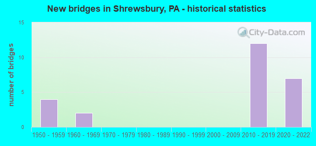
- New bridges - historical statistics
- 41950-1959
- 21960-1969
- 122010-2019
- 72020-2022


- Bridge Condition - Deck
- 22.2%Excellent
- 33.3%Very good
- 22.2%Good
- 11.1%Satisfactory
- 11.1%Fair

- Bridge Condition - Superstructure
- 22.2%Excellent
- 33.3%Very good
- 22.2%Good
- 22.2%Fair

- Bridge Condition - Substructure
- 11.1%Excellent
- 44.4%Very good
- 11.1%Good
- 11.1%Satisfactory
- 11.1%Fair
- 11.1%Poor

- Bridge Condition - Channel
- 33.3%Good
- 66.7%Satisfactory

- Bridge Condition - Culverts
- 50.0%Good
- 50.0%Satisfactory
Find on map >> Show street view
Structure Number: 37406, Location: 1 MI.S.E. OF SHREWSBURY (Lat: 39.760172, Lng: -76.663869), Route carried "on" structure: Interstate 83, Year Built: 1958, Status: Open, Structure Length: 5.27m (17.29ft), Average Daily Traffic: 40,238 (year 2021), Truck Traffic: 18%, Average Future Daily Traffic: 51,767 (year 2032), Design Load: HS 20, Features Intersected: T441; RR; Tulna Rd
Minimum Vertical Clearance: 30+ m (98+ ft), Kilometerpoint: 4.027, Lanes on structure: 4, Lanes under structure: 2, Base Highway Network: Yes, Owner: State Highway Agency, Approaching Roadway Width: 26.8m (87.9ft), Skew: 33 degrees, Material/Design: Steel continuous, Design/Construction: Stringer/Multi-beam, Number Of Spans In Main Unit: 3, Length of Maximum Span: 24.1m (79.1ft), Curb or Sidewalk Widths: Left: 0.2m (0.7ft), Right: 0.2m (0.7ft), Curb-To-Curb Width: 25.6m (84.0ft), Out-to-Out Width: 26.7m (87.6ft)
Condition: Deck: Satisfactory, Superstructure: Fair, Substructure: Fair, Operating Rating: 59.0 metric tons, Method Used To Determine Operating Rating: Load Factor (LF), Inventory Rating: 35.4 metric tons, Method Used To Determine Inventory Rating: Load Factor (LF), Structural Evaluation: Somewhat better than minimum adequacy, Deck Geometry: Superior to present desirable criteria, Underclear: Superior to present desirable criteria, Approach Roadway Alignment: Equal to present desirable criteria, Length Of Structure Improvement: 6.30m (20.67ft), Designated Inspection Frequency: Every 24 months, Inspection Date: July 2021, Bridge Improvement Cost: $454,000, Roadway Improvement Cost: $1,337,000, Total Project Cost: $6,129,000, Deck Structure Type: Concrete Cast-file-Place, Wearing Surface/Protective System: Wearing Surface: Latex Concrete
Find on map >> Show street view
Structure Number: 37409, Location: 1 MI.N.E. OF SHREWSBURY (Lat: 39.776303, Lng: -76.669581), Route carried "on" structure: Interstate 83, Year Built: 1958, Status: Open, Structure Length: 1.55m (5.09ft), Average Daily Traffic: 46,939 (year 2022), Truck Traffic: 17%, Average Future Daily Traffic: 51,767 (year 2032), Design Load: HS 20, Features Intersected: SR 2097
Minimum Vertical Clearance: 30+ m (98+ ft), Kilometerpoint: 5.636, Lanes on structure: 4, Lanes under structure: 2, Base Highway Network: Yes, Owner: State Highway Agency, Approaching Roadway Width: 26.8m (87.9ft), Skew: 34 degrees, Material/Design: Concrete, Design/Construction: Tee Beam, Number Of Spans In Main Unit: 1, Length of Maximum Span: 14.0m (45.9ft), Curb or Sidewalk Widths: Left: 0.2m (0.7ft), Right: 0.2m (0.7ft), Curb-To-Curb Width: 25.6m (84.0ft), Out-to-Out Width: 26.7m (87.6ft)
Condition: Deck: Fair, Superstructure: Good, Substructure: Satisfactory, Operating Rating: 89.8 metric tons, Method Used To Determine Operating Rating: Load Factor (LF), Inventory Rating: 55.3 metric tons, Method Used To Determine Inventory Rating: Load Factor (LF), Structural Evaluation: Equal to present minimum criteria, Deck Geometry: Superior to present desirable criteria, Underclear: Equal to present minimum criteria, Approach Roadway Alignment: Equal to present desirable criteria, Length Of Structure Improvement: 2.20m (7.22ft), Designated Inspection Frequency: Every 24 months, Inspection Date: July 2021, Deck Structure Type: Concrete Cast-file-Place, Wearing Surface/Protective System: Wearing Surface: Latex Concrete
Find on map >> Show street view
Structure Number: 37629, Location: 0.5 MI N OF TOINA (Lat: 39.764289, Lng: -76.650689), Route carried "on" structure: State highway 851, Year Built: 1967, Status: Open, Structure Length: 0.94m (3.08ft), Average Daily Traffic: 8,767 (year 2022), Truck Traffic: 13%, Average Future Daily Traffic: 14,144 (year 2032), Design Load: HS 20, Features Intersected: DEER CREEK
Minimum Vertical Clearance: 30+ m (98+ ft), Kilometerpoint: 19.748, Lanes on structure: 2, Base Highway Network: Yes, Owner: State Highway Agency, Approaching Roadway Width: 8.5m (27.9ft), Skew: 4 degrees, Material/Design: Concrete, Design/Construction: Culvert, Number Of Spans In Main Unit: 1, Length of Maximum Span: 9.4m (30.8ft)
Condition: Channel: Satisfactory, Culverts: Satisfactory, Operating Rating: 69.9 metric tons, Method Used To Determine Operating Rating: Allowable Stress (AS), Inventory Rating: 46.3 metric tons, Method Used To Determine Inventory Rating: Allowable Stress (AS), Structural Evaluation: Equal to present minimum criteria, Waterway Adequacy: Superior to present desirable criteria, Approach Roadway Alignment: Equal to present desirable criteria, Length Of Structure Improvement: 1.30m (4.27ft), Designated Inspection Frequency: Every 48 months, Inspection Date: July 2019
Find on map >> Show street view
Structure Number: 38219, Location: 2W STEWARTWN/DEER CREEK (Lat: 39.751278, Lng: -76.640319), Route carried "on" structure: City street , Year Built: 1967, Status: Open, Structure Length: 1.62m (5.31ft), Average Daily Traffic: 260 (year 2011), Truck Traffic: 5%, Average Future Daily Traffic: 223 (year 2031), Design Load: HS 20, Features Intersected: DEER CREEK, Facility Carried by Structure: T540; 5 FORKS RD
Minimum Vertical Clearance: 30+ m (98+ ft), Kilometerpoint: 0.000, Lanes on structure: 2, Owner: County Highway Agency, Approaching Roadway Width: 5.2m (17.1ft), Material/Design: Prestressed concrete, Design/Construction: Box Beam or Girders - Multiple, Number Of Spans In Main Unit: 1, Length of Maximum Span: 15.5m (50.9ft), Curb-To-Curb Width: 8.2m (26.9ft), Out-to-Out Width: 9.2m (30.2ft)
Condition: Deck: Good, Superstructure: Fair, Substructure: Poor, Channel: Satisfactory, Operating Rating: 62.6 metric tons, Method Used To Determine Operating Rating: Load Factor (LF), Inventory Rating: 28.1 metric tons, Method Used To Determine Inventory Rating: Load Factor (LF), Structural Evaluation: Meets minimum limits, Deck Geometry: Somewhat better than minimum adequacy, Waterway Adequacy: Better than present minimum criteria, Approach Roadway Alignment: Equal to present minimum criteria, Length Of Structure Improvement: 2.30m (7.55ft), Designated Inspection Frequency: Every 24 months, Inspection Date: July 2021, Deck Structure Type: Concrete Cast-file-Place, Wearing Surface/Protective System: Wearing Surface: Monolithic Concrete
Find on map >> Show street view
Structure Number: 45815, Location: 1Mile N.E of Shrewsbury (Lat: 39.807606, Lng: -76.679142), Route carried "on" structure: State highway , Year Built: 2010, Status: Open, Structure Length: 4.27m (14.01ft), Average Daily Traffic: 1,018 (year 2022), Truck Traffic: 7%, Average Future Daily Traffic: 1,455 (year 2032), Design Load: HL 93, Features Intersected: 83 NB and SB, Facility Carried by Structure: SR.2093 Hain Road
Minimum Vertical Clearance: 30+ m (98+ ft), Kilometerpoint: 4.253, Lanes on structure: 2, Lanes under structure: 4, Owner: State Highway Agency, Approaching Roadway Width: 7.3m (24.0ft), Skew: 2 degrees, Material/Design: Prestressed concrete continuous, Design/Construction: Box Beam or Girders - Single/Spread, Number Of Spans In Main Unit: 2, Length of Maximum Span: 21.0m (68.9ft), Curb or Sidewalk Widths: Left: 0.2m (0.7ft), Right: 0.2m (0.7ft), Curb-To-Curb Width: 7.3m (24.0ft), Out-to-Out Width: 10.2m (33.5ft)
Condition: Deck: Good, Superstructure: Very good, Substructure: Good, Operating Rating: 60.8 metric tons, Method Used To Determine Operating Rating: Load and Resistance Factor (LRFR), Inventory Rating: 41.7 metric tons, Method Used To Determine Inventory Rating: Load and Resistance Factor (LRFR), Structural Evaluation: Better than present minimum criteria, Deck Geometry: Meets minimum limits, Underclear: High priority of corrective action, Approach Roadway Alignment: Better than present minimum criteria, Designated Inspection Frequency: Every 24 months, Inspection Date: July 2021, Deck Structure Type: Concrete Cast-file-Place, Wearing Surface/Protective System: Wearing Surface: Monolithic Concrete, Deck Protection: Epoxy Coated Reinforcing
Find on map >> Show street view
Structure Number: 46897, Location: 2 MI.E. OF SHREWSBERRY (Lat: 39.724558, Lng: -76.657069), Route carried "on" structure: State highway , Year Built: 2011, Status: Open, Structure Length: 6.19m (20.31ft), Average Daily Traffic: 768 (year 2020), Truck Traffic: 3%, Average Future Daily Traffic: 1,232 (year 2032), Design Load: HL 93, Features Intersected: I-83; SR 0083, Facility Carried by Structure: SR 2076 Stew-twn
Minimum Vertical Clearance: 30+ m (98+ ft), Kilometerpoint: 0.000, Lanes on structure: 2, Lanes under structure: 8, Owner: State Highway Agency, Approaching Roadway Width: 7.3m (24.0ft), Material/Design: Prestressed concrete, Design/Construction: Stringer/Multi-beam, Number Of Spans In Main Unit: 2, Length of Maximum Span: 30.5m (100.1ft), Curb or Sidewalk Widths: Left: 0.2m (0.7ft), Right: 0.2m (0.7ft), Curb-To-Curb Width: 9.8m (32.2ft), Out-to-Out Width: 10.8m (35.4ft)
Condition: Deck: Very good, Superstructure: Very good, Substructure: Very good, Operating Rating: 58.3 metric tons, Method Used To Determine Operating Rating: Assigned ratings based on Load and Resistance Factor Design (LRFD) reported by rating factor (RF) using HL93 loadings, Inventory Rating: 36.6 metric tons, Method Used To Determine Inventory Rating: Assigned ratings based on Load and Resistance Factor Design (LRFD) reported by rating factor (RF) using HL93 loadings, Structural Evaluation: Equal to present desirable criteria, Deck Geometry: Equal to present minimum criteria, Underclear: High priority of corrective action, Approach Roadway Alignment: Equal to present desirable criteria, Designated Inspection Frequency: Every 24 months, Inspection Date: October 2019, Deck Structure Type: Concrete Cast-file-Place, Wearing Surface/Protective System: Wearing Surface: Monolithic Concrete, Deck Protection: Epoxy Coated Reinforcing
Find on map >> Show street view
Structure Number: 46898, Location: OVER I-83 (Lat: 39.747828, Lng: -76.661861), Route carried "on" structure: State highway , Year Built: 2011, Status: Open, Structure Length: 6.19m (20.31ft), Average Daily Traffic: 1,774 (year 2022), Truck Traffic: 4%, Average Future Daily Traffic: 1,282 (year 2032), Design Load: HL 93, Features Intersected: I-83; SR 0083, Facility Carried by Structure: SR 2078;WINDY HILL
Minimum Vertical Clearance: 30.45m (99.90ft), Kilometerpoint: 1.205, Lanes on structure: 2, Lanes under structure: 8, Owner: State Highway Agency, Approaching Roadway Width: 7.3m (24.0ft), Skew: 1 degrees, Material/Design: Prestressed concrete, Design/Construction: Stringer/Multi-beam, Number Of Spans In Main Unit: 2, Length of Maximum Span: 30.2m (99.1ft), Curb or Sidewalk Widths: Left: 0.2m (0.7ft), Right: 0.2m (0.7ft), Curb-To-Curb Width: 9.8m (32.2ft), Out-to-Out Width: 10.8m (35.4ft)
Condition: Deck: Very good, Superstructure: Very good, Substructure: Very good, Operating Rating: 60.3 metric tons, Method Used To Determine Operating Rating: Assigned ratings based on Load and Resistance Factor Design (LRFD) reported by rating factor (RF) using HL93 loadings, Inventory Rating: 37.6 metric tons, Method Used To Determine Inventory Rating: Assigned ratings based on Load and Resistance Factor Design (LRFD) reported by rating factor (RF) using HL93 loadings, Structural Evaluation: Equal to present desirable criteria, Deck Geometry: Somewhat better than minimum adequacy, Underclear: High priority of corrective action, Approach Roadway Alignment: Better than present minimum criteria, Designated Inspection Frequency: Every 24 months, Inspection Date: November 2019, Deck Structure Type: Concrete Cast-file-Place, Wearing Surface/Protective System: Wearing Surface: Monolithic Concrete, Deck Protection: Epoxy Coated Reinforcing
Find on map >> Show street view
Structure Number: 47043, Location: 1 MI.N.E. OF SHREWSBERRY (Lat: 39.781967, Lng: -76.672922), Route carried "on" structure: State highway , Year Built: 2012, Status: Open, Structure Length: 4.33m (14.21ft), Average Daily Traffic: 2,852 (year 2022), Truck Traffic: 1%, Average Future Daily Traffic: 3,996 (year 2032), Design Load: HL 93, Features Intersected: I-83; SR 0083, Facility Carried by Structure: SR 2074
Minimum Vertical Clearance: 30+ m (98+ ft), Kilometerpoint: 0.690, Lanes on structure: 2, Lanes under structure: 8, Owner: State Highway Agency, Approaching Roadway Width: 7.3m (24.0ft), Skew: 1 degrees, Material/Design: Prestressed concrete continuous, Design/Construction: Stringer/Multi-beam, Number Of Spans In Main Unit: 2, Length of Maximum Span: 21.0m (68.9ft), Curb or Sidewalk Widths: Left: 0.2m (0.7ft), Right: 0.2m (0.7ft), Curb-To-Curb Width: 9.8m (32.2ft), Out-to-Out Width: 10.8m (35.4ft)
Condition: Deck: Very good, Superstructure: Good, Substructure: Very good, Operating Rating: 62.2 metric tons, Method Used To Determine Operating Rating: Assigned ratings based on Load and Resistance Factor Design (LRFD) reported by rating factor (RF) using HL93 loadings, Inventory Rating: 38.9 metric tons, Method Used To Determine Inventory Rating: Assigned ratings based on Load and Resistance Factor Design (LRFD) reported by rating factor (RF) using HL93 loadings, Structural Evaluation: Better than present minimum criteria, Deck Geometry: Meets minimum limits, Underclear: High priority of corrective action, Approach Roadway Alignment: Equal to present desirable criteria, Designated Inspection Frequency: Every 24 months, Inspection Date: July 2021, Deck Structure Type: Concrete Cast-file-Place, Wearing Surface/Protective System: Wearing Surface: Monolithic Concrete, Deck Protection: Epoxy Coated Reinforcing
Find on map >> Show street view
Structure Number: 68361, Location: 0.7 MI.E. OF SHREWSBURY (Lat: 39.771611, Lng: -76.667622), Route carried "on" structure: Interstate 83, Year Built: 2021, Status: Open, Structure Length: 4.08m (13.39ft), Average Daily Traffic: 23,419 (year 2022), Truck Traffic: 17%, Average Future Daily Traffic: 25,923 (year 2035), Design Load: HL 93, Features Intersected: SR 0851 EB & WB
Minimum Vertical Clearance: 30+ m (98+ ft), Kilometerpoint: 5.636, Lanes on structure: 4, Lanes under structure: 6, Base Highway Network: Yes, Owner: State Highway Agency, Approaching Roadway Width: 17.7m (58.1ft), Skew: 31 degrees, Material/Design: Prestressed concrete continuous, Design/Construction: Box Beam or Girders - Single/Spread, Number Of Spans In Main Unit: 2, Length of Maximum Span: 20.4m (66.9ft), Curb or Sidewalk Widths: Left: 0.2m (0.7ft), Right: 0.2m (0.7ft), Curb-To-Curb Width: 17.7m (58.1ft), Out-to-Out Width: 18.7m (61.4ft)
Condition: Deck: Excellent, Superstructure: Excellent, Substructure: Very good, Operating Rating: 45.7 metric tons, Method Used To Determine Operating Rating: Assigned ratings based on Load and Resistance Factor Design (LRFD) reported by rating factor (RF) using HL93 loadings, Inventory Rating: 35.3 metric tons, Method Used To Determine Inventory Rating: Assigned ratings based on Load and Resistance Factor Design (LRFD) reported by rating factor (RF) using HL93 loadings, Structural Evaluation: Equal to present desirable criteria, Deck Geometry: Meets minimum limits, Underclear: High priority of corrective action, Approach Roadway Alignment: Equal to present desirable criteria, Designated Inspection Frequency: Every 24 months, Inspection Date: July 2021, Deck Structure Type: Concrete Cast-file-Place, Wearing Surface/Protective System: Wearing Surface: Monolithic Concrete, Deck Protection: Epoxy Coated Reinforcing
Find on map >> Show street view
Structure Number: 68362, Location: 0.7 MI.E. OF SHREWSBURY (Lat: 39.771611, Lng: -76.667622), Route carried "on" structure: Interstate 83, Year Built: 2021, Status: Open, Structure Length: 4.08m (13.39ft), Average Daily Traffic: 23,520 (year 2022), Truck Traffic: 17%, Average Future Daily Traffic: 25,844 (year 2035), Design Load: HL 93, Features Intersected: SR 0851 EB & WB
Minimum Vertical Clearance: 30+ m (98+ ft), Kilometerpoint: 5.644, Lanes on structure: 4, Lanes under structure: 4, Base Highway Network: Yes, Owner: State Highway Agency, Approaching Roadway Width: 17.7m (58.1ft), Skew: 31 degrees, Material/Design: Prestressed concrete continuous, Design/Construction: Box Beam or Girders - Single/Spread, Number Of Spans In Main Unit: 2, Length of Maximum Span: 20.4m (66.9ft), Curb or Sidewalk Widths: Left: 0.2m (0.7ft), Right: 0.2m (0.7ft), Curb-To-Curb Width: 17.7m (58.1ft), Out-to-Out Width: 18.7m (61.4ft)
Condition: Deck: Excellent, Superstructure: Excellent, Substructure: Excellent, Operating Rating: 50.2 metric tons, Method Used To Determine Operating Rating: Assigned ratings based on Load and Resistance Factor Design (LRFD) reported by rating factor (RF) using HL93 loadings, Inventory Rating: 38.9 metric tons, Method Used To Determine Inventory Rating: Assigned ratings based on Load and Resistance Factor Design (LRFD) reported by rating factor (RF) using HL93 loadings, Structural Evaluation: Superior to present desirable criteria, Deck Geometry: Meets minimum limits, Underclear: High priority of corrective action, Approach Roadway Alignment: Equal to present desirable criteria, Designated Inspection Frequency: Every 24 months, Inspection Date: July 2021, Deck Structure Type: Concrete Cast-file-Place, Wearing Surface/Protective System: Wearing Surface: Monolithic Concrete, Membrane: Preformed Fabric, Deck Protection: Epoxy Coated Reinforcing
Find on map >> Show street view
Structure Number: 68623, Location: 3.3 NE SHREWSBURY (Lat: 39.895639, Lng: -76.652933), Route carried "on" structure: Business City street 442, Year Built: 2021, Status: Open, Structure Length: 0.64m (2.10ft), Average Daily Traffic: 100 (year 2021), Truck Traffic: 1%, Average Future Daily Traffic: 125 (year 2031), Design Load: HS 20, Features Intersected: E BRANCH CORODUS CK
Minimum Vertical Clearance: 30+ m (98+ ft), Kilometerpoint: 0.000, Lanes on structure: 2, Owner: Town or Township Highway Agency, Approaching Roadway Width: 6.7m (22.0ft), Skew: 4 degrees, Material/Design: Prestressed concrete, Design/Construction: Culvert, Number Of Spans In Main Unit: 1, Length of Maximum Span: 6.4m (21.0ft), Curb-To-Curb Width: 6.7m (22.0ft), Out-to-Out Width: 6.7m (22.0ft)
Condition: Channel: Good, Culverts: Good, Operating Rating: 63.5 metric tons, Method Used To Determine Operating Rating: Load and Resistance Factor (LRFR), Inventory Rating: 49.0 metric tons, Method Used To Determine Inventory Rating: Load and Resistance Factor (LRFR), Structural Evaluation: Better than present minimum criteria, Deck Geometry: Somewhat better than minimum adequacy, Waterway Adequacy: Equal to present minimum criteria, Approach Roadway Alignment: Equal to present desirable criteria, Designated Inspection Frequency: Every 24 months, Inspection Date: November 2021, Wearing Surface/Protective System: Wearing Surface: Bituminous, Membrane: Built-up, Deck Protection: Epoxy Coated Reinforcing
Find on map >> Show street view
Structure Number: 37406, Location: 1 MI.S.E. OF SHREWSBURY (Lat: 39.760172, Lng: -76.663869), Route carried "under" structure: City street T441, Year Built: 1958, Structure Length: 0. m, Average Daily Traffic: 200 (year 1985), Truck Traffic: 1%, Features Intersected: T441; RR; Tulna Rd, Facility Carried by Structure: I-83; SR 0083
Minimum Vertical Clearance: 5.73m (18.80ft), Kilometerpoint: 0.000, Lanes on structure: 4, Lanes under structure: 2, Material/Design: Steel continuous, Design/Construction: Stringer/Multi-beam, Length of Maximum Span: 24.1m (79.1ft)
Find on map >> Show street view
Structure Number: 37409, Location: 1 MI.N.E. OF SHREWSBURY (Lat: 39.776303, Lng: -76.669581), Route carried "under" structure: State highway , Year Built: 1958, Structure Length: 0. m, Average Daily Traffic: 4,166 (year 2021), Truck Traffic: 7%, Features Intersected: SR 2097, Facility Carried by Structure: I-83; SR 0083
Minimum Vertical Clearance: 4.42m (14.50ft), Kilometerpoint: 0.624, Lanes on structure: 4, Lanes under structure: 2, Material/Design: Concrete, Design/Construction: Tee Beam, Length of Maximum Span: 14.0m (45.9ft)
Find on map >> Show street view
Structure Number: 45815, Location: 1Mile N.E of Shrewsbury (Lat: 39.807606, Lng: -76.679142), Route carried "under" structure: Interstate 83, Year Built: 2010, Structure Length: 0. m, Average Daily Traffic: 23,419 (year 2022), Truck Traffic: 17%, Features Intersected: 83 NB and SB, Facility Carried by Structure: SR.2093 Hain Road
Minimum Vertical Clearance: 5.33m (17.49ft), Kilometerpoint: 9.659, Lanes on structure: 2, Lanes under structure: 2, Material/Design: Prestressed concrete continuous, Design/Construction: Box Beam or Girders - Single/Spread, Length of Maximum Span: 21.0m (68.9ft)
Find on map >> Show street view
Structure Number: 45815, Location: 1Mile N.E of Shrewsbury (Lat: 39.807606, Lng: -76.679142), Route carried "under" structure: Interstate 83, Year Built: 2010, Structure Length: 0. m, Average Daily Traffic: 23,520 (year 2022), Truck Traffic: 17%, Features Intersected: 83 NB and SB, Facility Carried by Structure: SR.2093 Hain Road
Minimum Vertical Clearance: 5.94m (19.49ft), Kilometerpoint: 9.664, Lanes on structure: 2, Lanes under structure: 2, Material/Design: Prestressed concrete continuous, Design/Construction: Box Beam or Girders - Single/Spread, Length of Maximum Span: 21.0m (68.9ft)
Find on map >> Show street view
Structure Number: 46897, Location: 2 MI.E. OF SHREWSBERRY (Lat: 39.724558, Lng: -76.657069), Route carried "under" structure: Interstate 83, Year Built: 2011, Structure Length: 0. m, Average Daily Traffic: 20,053 (year 2021), Truck Traffic: 18%, Features Intersected: I-83; SR 0083, Facility Carried by Structure: SR 2076 Stew-twn
Minimum Vertical Clearance: 5.03m (16.50ft), Kilometerpoint: 0.000, Lanes on structure: 2, Lanes under structure: 4, Material/Design: Prestressed concrete, Design/Construction: Stringer/Multi-beam, Length of Maximum Span: 30.5m (100.1ft)
Find on map >> Show street view
Structure Number: 46897, Location: 2 MI.E. OF SHREWSBERRY (Lat: 39.724558, Lng: -76.657069), Route carried "under" structure: Interstate 83, Year Built: 2011, Structure Length: 0. m, Average Daily Traffic: 20,185 (year 2021), Truck Traffic: 18%, Features Intersected: I-83; SR 0083, Facility Carried by Structure: SR 2076 Stew-twn
Minimum Vertical Clearance: 5.03m (16.50ft), Kilometerpoint: 0.000, Lanes on structure: 2, Lanes under structure: 4, Material/Design: Prestressed concrete, Design/Construction: Stringer/Multi-beam, Length of Maximum Span: 30.5m (100.1ft)
Find on map >> Show street view
Structure Number: 46898, Location: OVER I-83 (Lat: 39.747828, Lng: -76.661861), Route carried "under" structure: Interstate 83, Year Built: 2011, Structure Length: 0. m, Average Daily Traffic: 20,053 (year 2021), Truck Traffic: 18%, Features Intersected: I-83; SR 0083, Facility Carried by Structure: SR 2078;WINDY HILL
Minimum Vertical Clearance: 5.03m (16.50ft), Kilometerpoint: 2.428, Lanes on structure: 2, Lanes under structure: 4, Material/Design: Prestressed concrete, Design/Construction: Stringer/Multi-beam, Length of Maximum Span: 30.2m (99.1ft)
Find on map >> Show street view
Structure Number: 46898, Location: OVER I-83 (Lat: 39.747828, Lng: -76.661861), Route carried "under" structure: Interstate 83, Year Built: 2011, Structure Length: 0. m, Average Daily Traffic: 20,185 (year 2021), Truck Traffic: 18%, Features Intersected: I-83; SR 0083, Facility Carried by Structure: SR 2078;WINDY HILL
Minimum Vertical Clearance: 5.03m (16.50ft), Kilometerpoint: 2.417, Lanes on structure: 2, Lanes under structure: 4, Material/Design: Prestressed concrete, Design/Construction: Stringer/Multi-beam, Length of Maximum Span: 30.2m (99.1ft)
Find on map >> Show street view
Structure Number: 47043, Location: 1 MI.N.E. OF SHREWSBERRY (Lat: 39.781967, Lng: -76.672922), Route carried "under" structure: Interstate 83, Year Built: 2012, Structure Length: 0. m, Average Daily Traffic: 23,419 (year 2022), Truck Traffic: 17%, Features Intersected: I-83; SR 0083, Facility Carried by Structure: SR 2074
Minimum Vertical Clearance: 5.52m (18.11ft), Kilometerpoint: 6.441, Lanes on structure: 2, Lanes under structure: 4, Material/Design: Prestressed concrete continuous, Design/Construction: Stringer/Multi-beam, Length of Maximum Span: 21.0m (68.9ft)
Find on map >> Show street view
Structure Number: 47043, Location: 1 MI.N.E. OF SHREWSBERRY (Lat: 39.781967, Lng: -76.672922), Route carried "under" structure: Interstate 83, Year Built: 2012, Structure Length: 0. m, Average Daily Traffic: 23,520 (year 2022), Truck Traffic: 17%, Features Intersected: I-83; SR 0083, Facility Carried by Structure: SR 2074
Minimum Vertical Clearance: 5.30m (17.39ft), Kilometerpoint: 6.444, Lanes on structure: 2, Lanes under structure: 4, Material/Design: Prestressed concrete continuous, Design/Construction: Stringer/Multi-beam, Length of Maximum Span: 21.0m (68.9ft)
Find on map >> Show street view
Structure Number: 68361, Location: 0.7 MI.E. OF SHREWSBURY (Lat: 39.771611, Lng: -76.667622), Route carried "under" structure: State highway 851, Year Built: 2021, Structure Length: 0. m, Average Daily Traffic: 8,470 (year 2020), Truck Traffic: 8%, Features Intersected: SR 0851 EB & WB, Facility Carried by Structure: I-83; SR 0083 NB
Minimum Vertical Clearance: 5.76m (18.90ft), Kilometerpoint: 17.759, Lanes on structure: 4, Lanes under structure: 4, Material/Design: Prestressed concrete continuous, Design/Construction: Box Beam or Girders - Single/Spread, Length of Maximum Span: 20.4m (66.9ft)
Find on map >> Show street view
Structure Number: 68361, Location: 0.7 MI.E. OF SHREWSBURY (Lat: 39.771611, Lng: -76.667622), Route carried "under" structure: State highway , Year Built: 2021, Structure Length: 0. m, Average Daily Traffic: 300 (year 2020), Truck Traffic: 10%, Features Intersected: SR 0851 EB & WB, Facility Carried by Structure: I-83; SR 0083 NB
Minimum Vertical Clearance: 6.10m (20.01ft), Kilometerpoint: 17.759, Lanes on structure: 4, Lanes under structure: 2, Material/Design: Prestressed concrete continuous, Design/Construction: Box Beam or Girders - Single/Spread, Length of Maximum Span: 20.4m (66.9ft)
Find on map >> Show street view
Structure Number: 68362, Location: 0.7 MI.E. OF SHREWSBURY (Lat: 39.771611, Lng: -76.667622), Route carried "under" structure: State highway 851, Year Built: 2021, Structure Length: 0. m, Average Daily Traffic: 8,470 (year 2020), Truck Traffic: 8%, Features Intersected: SR 0851 EB & WB, Facility Carried by Structure: I-83; SR 0083 SB
Minimum Vertical Clearance: 4.91m (16.11ft), Kilometerpoint: 17.759, Lanes on structure: 4, Lanes under structure: 2, Material/Design: Prestressed concrete continuous, Design/Construction: Box Beam or Girders - Single/Spread, Length of Maximum Span: 20.4m (66.9ft)
Find on map >> Show street view
Structure Number: 68362, Location: 0.7 MI.E. OF SHREWSBURY (Lat: 39.771611, Lng: -76.667622), Route carried "under" structure: State highway , Year Built: 2021, Structure Length: 0. m, Average Daily Traffic: 300 (year 2020), Truck Traffic: 10%, Features Intersected: SR 0851 EB & WB, Facility Carried by Structure: I-83; SR 0083 SB
Minimum Vertical Clearance: 5.18m (16.99ft), Kilometerpoint: 17.759, Lanes on structure: 4, Lanes under structure: 2, Material/Design: Prestressed concrete continuous, Design/Construction: Box Beam or Girders - Single/Spread, Length of Maximum Span: 20.4m (66.9ft)