Bridge Statistics for Shiremanstown, Pennsylvania (PA)
Condition, Traffic, Stress, Structural Evaluation, Project Costs
- National Bridge Inventory (NBI) Statistics
- 27Number of bridges
- 194ft / 58.9mTotal length
- $4,216,000Total costs
- 675,632Total average daily traffic
- 75,405Total average daily truck traffic
- National Bridge Inventory (NBI) Registered Bridges for Shiremanstown
- No street view available for this location
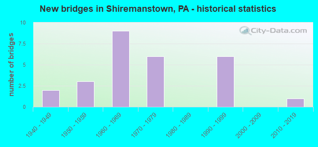
- New bridges - historical statistics
- 21940-1949
- 31950-1959
- 91960-1969
- 61970-1979
- 61990-1999
- 12010-2019

- Reconstructed bridges - Historical Statistics
- 11980-1989
- 31990-1999
- 12000-2009


- Bridge Condition - Deck
- 16.7%Very good
- 41.7%Good
- 33.3%Satisfactory
- 8.3%Fair

- Bridge Condition - Superstructure
- 8.3%Excellent
- 8.3%Very good
- 41.7%Good
- 16.7%Satisfactory
- 25.0%Fair

- Bridge Condition - Substructure
- 8.3%Very good
- 41.7%Good
- 25.0%Satisfactory
- 25.0%Fair

- Bridge Condition - Channel
- 66.7%Good
- 33.3%Fair
Find on map >> Show street view
Structure Number: 13607, Location: N of Slate Hill Rd Exit (Lat: 40.217597, Lng: -76.942819), Route carried "on" structure: US 15, Year Built: 1956, Status: Open, Structure Length: 0.85m (2.79ft), Average Daily Traffic: 72,895 (year 2022), Truck Traffic: 8%, Average Future Daily Traffic: 72,515 (year 2032), Design Load: HS 20, Features Intersected: Cedar Run
Minimum Vertical Clearance: 30+ m (98+ ft), Kilometerpoint: 9.064, Lanes on structure: 4, Base Highway Network: Yes, Owner: State Highway Agency, Approaching Roadway Width: 27.4m (89.9ft), Skew: 34 degrees, Material/Design: Concrete, Design/Construction: Culvert, Number Of Spans In Main Unit: 1, Length of Maximum Span: 8.5m (27.9ft)
Condition: Channel: Good, Culverts: Satisfactory, Operating Rating: 49.0 metric tons, Method Used To Determine Operating Rating: Field evaluation and documented engineering judgment, Inventory Rating: 32.7 metric tons, Method Used To Determine Inventory Rating: Field evaluation and documented engineering judgment, Structural Evaluation: Equal to present minimum criteria, Waterway Adequacy: Better than present minimum criteria, Approach Roadway Alignment: Equal to present desirable criteria, Length Of Structure Improvement: 1.50m (4.92ft), Designated Inspection Frequency: Every 24 months, Inspection Date: June 2020
Find on map >> Show street view
Structure Number: 13755, Location: INTERSECT. OF US11&PA 581 (Lat: 40.239997, Lng: -76.978989), Route carried "on" structure: State highway 581, Year Built: 1995, Status: Open, Structure Length: 10.18m (33.40ft), Average Daily Traffic: 53,277 (year 2022), Truck Traffic: 11%, Average Future Daily Traffic: 58,856 (year 2032), Design Load: HS 25 or greater, Features Intersected: SR 8048 RAMP A&B
Minimum Vertical Clearance: 30+ m (98+ ft), Kilometerpoint: 3.360, Lanes on structure: 2, Lanes under structure: 6, Base Highway Network: Yes, Owner: State Highway Agency, Approaching Roadway Width: 25.9m (85.0ft), Skew: 35 degrees, Material/Design: Steel continuous, Design/Construction: Stringer/Multi-beam, Number Of Spans In Main Unit: 2, Length of Maximum Span: 54.9m (180.1ft), Curb or Sidewalk Widths: Left: 0.5m (1.6ft), Right: 0.5m (1.6ft), Curb-To-Curb Width: 29.6m (97.1ft), Out-to-Out Width: 31.5m (103.3ft)
Condition: Deck: Good, Superstructure: Very good, Substructure: Good, Operating Rating: 72.6 metric tons, Method Used To Determine Operating Rating: Load Factor (LF), Inventory Rating: 43.5 metric tons, Method Used To Determine Inventory Rating: Load Factor (LF), Structural Evaluation: Better than present minimum criteria, Deck Geometry: Superior to present desirable criteria, Underclear: Superior to present desirable criteria, Approach Roadway Alignment: Equal to present desirable criteria, Length Of Structure Improvement: 10.90m (35.76ft), Designated Inspection Frequency: Every 24 months, Inspection Date: June 2020, Deck Structure Type: Concrete Cast-file-Place, Wearing Surface/Protective System: Wearing Surface: Monolithic Concrete, Deck Protection: Epoxy Coated Reinforcing
Find on map >> Show street view
Structure Number: 13756, Location: 581/11 @ Carlisle Pk (Lat: 40.237683, Lng: -76.976753), Route carried "on" structure: State highway 581, Year Built: 1995, Status: Open, Structure Length: 4.97m (16.31ft), Average Daily Traffic: 25,297 (year 2022), Truck Traffic: 12%, Average Future Daily Traffic: 30,023 (year 2032), Design Load: HS 25 or greater, Features Intersected: SR 1010, CARLISLE PIKE
Minimum Vertical Clearance: 30+ m (98+ ft), Kilometerpoint: 4.165, Lanes on structure: 4, Lanes under structure: 4, Base Highway Network: Yes, Owner: State Highway Agency, Approaching Roadway Width: 27.7m (90.9ft), Skew: 36 degrees, Material/Design: Steel, Design/Construction: Stringer/Multi-beam, Number Of Spans In Main Unit: 1, Length of Maximum Span: 48.8m (160.1ft), Curb or Sidewalk Widths: Left: 0.2m (0.7ft), Right: 0.2m (0.7ft), Curb-To-Curb Width: 26.8m (87.9ft), Out-to-Out Width: 27.9m (91.5ft)
Condition: Deck: Satisfactory, Superstructure: Good, Substructure: Good, Operating Rating: 55.3 metric tons, Method Used To Determine Operating Rating: Load Factor (LF), Inventory Rating: 32.7 metric tons, Method Used To Determine Inventory Rating: Load Factor (LF), Structural Evaluation: Better than present minimum criteria, Deck Geometry: Superior to present desirable criteria, Underclear: Superior to present desirable criteria, Approach Roadway Alignment: Equal to present desirable criteria, Length Of Structure Improvement: 5.90m (19.36ft), Designated Inspection Frequency: Every 24 months, Inspection Date: June 2020, Deck Structure Type: Concrete Cast-file-Place, Wearing Surface/Protective System: Wearing Surface: Latex Concrete, Deck Protection: Epoxy Coated Reinforcing
Find on map >> Show street view
Structure Number: 13757, Location: WEST OF CAMP HILL BOROUGH (Lat: 40.235061, Lng: -76.971867), Route carried "on" structure: US 11, Year Built: 1961, Year Reconstructed: 1996, Status: Open, Structure Length: 1.92m (6.30ft), Average Daily Traffic: 53,277 (year 2022), Truck Traffic: 11%, Average Future Daily Traffic: 58,856 (year 2032), Design Load: HS 25 or greater, Features Intersected: SR 1013, SPORTING HILL
Minimum Vertical Clearance: 30+ m (98+ ft), Kilometerpoint: 4.773, Lanes on structure: 4, Lanes under structure: 2, Base Highway Network: Yes, Owner: State Highway Agency, Approaching Roadway Width: 24.1m (79.1ft), Skew: 33 degrees, Material/Design: Prestressed concrete, Design/Construction: Box Beam or Girders - Multiple, Number Of Spans In Main Unit: 1, Length of Maximum Span: 19.2m (63.0ft), Curb or Sidewalk Widths: Left: 0.2m (0.7ft), Right: 0.2m (0.7ft), Curb-To-Curb Width: 23.5m (77.1ft), Out-to-Out Width: 25.3m (83.0ft)
Condition: Deck: Satisfactory, Superstructure: Satisfactory, Substructure: Satisfactory, Operating Rating: 89.8 metric tons, Method Used To Determine Operating Rating: Load Factor (LF), Inventory Rating: 47.2 metric tons, Method Used To Determine Inventory Rating: Load Factor (LF), Structural Evaluation: Equal to present minimum criteria, Deck Geometry: Superior to present desirable criteria, Underclear: Equal to present minimum criteria, Approach Roadway Alignment: Equal to present desirable criteria, Length Of Structure Improvement: 2.60m (8.53ft), Designated Inspection Frequency: Every 24 months, Inspection Date: June 2020, Deck Structure Type: Concrete Cast-file-Place, Wearing Surface/Protective System: Wearing Surface: Monolithic Concrete, Deck Protection: Epoxy Coated Reinforcing
Find on map >> Show street view
Structure Number: 13759, Location: CAMP HILL (Lat: 40.233147, Lng: -76.956206), Route carried "on" structure: US 11, Year Built: 1961, Year Reconstructed: 1996, Status: Open, Structure Length: 2.26m (7.41ft), Average Daily Traffic: 53,277 (year 2022), Truck Traffic: 11%, Average Future Daily Traffic: 58,856 (year 2032), Design Load: HS 25 or greater, Features Intersected: 2029 St Johns Church Rd
Minimum Vertical Clearance: 30+ m (98+ ft), Kilometerpoint: 5.887, Lanes on structure: 4, Lanes under structure: 2, Base Highway Network: Yes, Owner: State Highway Agency, Approaching Roadway Width: 20.7m (67.9ft), Skew: 34 degrees, Material/Design: Prestressed concrete, Design/Construction: Box Beam or Girders - Multiple, Number Of Spans In Main Unit: 1, Length of Maximum Span: 22.3m (73.2ft), Curb or Sidewalk Widths: Left: 0.2m (0.7ft), Right: 0.2m (0.7ft), Curb-To-Curb Width: 19.5m (64.0ft), Out-to-Out Width: 21.8m (71.5ft)
Condition: Deck: Good, Superstructure: Fair, Substructure: Fair, Operating Rating: 89.8 metric tons, Method Used To Determine Operating Rating: Load Factor (LF), Inventory Rating: 39.9 metric tons, Method Used To Determine Inventory Rating: Load Factor (LF), Structural Evaluation: Somewhat better than minimum adequacy, Deck Geometry: Somewhat better than minimum adequacy, Underclear: Somewhat better than minimum adequacy, Approach Roadway Alignment: Equal to present desirable criteria, Length Of Structure Improvement: 3.30m (10.83ft), Designated Inspection Frequency: Every 24 months, Inspection Date: June 2020, Bridge Improvement Cost: $17,000, Roadway Improvement Cost: $50,000, Total Project Cost: $228,000, Deck Structure Type: Concrete Cast-file-Place, Wearing Surface/Protective System: Wearing Surface: Monolithic Concrete, Deck Protection: Epoxy Coated Reinforcing
Find on map >> Show street view
Structure Number: 1376, Location: CAMP HILL (Lat: 40.232731, Lng: -76.951042), Route carried "on" structure: US 11, Year Built: 1961, Year Reconstructed: 1996, Status: Open, Structure Length: 4.11m (13.48ft), Average Daily Traffic: 62,521 (year 2022), Truck Traffic: 10%, Average Future Daily Traffic: 69,729 (year 2032), Design Load: HS 25 or greater, Features Intersected: 641;Trindle Rd
Minimum Vertical Clearance: 30+ m (98+ ft), Kilometerpoint: 6.574, Lanes on structure: 5, Lanes under structure: 8, Base Highway Network: Yes, Owner: State Highway Agency, Approaching Roadway Width: 25.6m (84.0ft), Skew: 36 degrees, Material/Design: Steel, Design/Construction: Stringer/Multi-beam, Number Of Spans In Main Unit: 1, Length of Maximum Span: 39.6m (129.9ft), Curb or Sidewalk Widths: Left: 0.2m (0.7ft), Right: 0.2m (0.7ft), Curb-To-Curb Width: 24.7m (81.0ft), Out-to-Out Width: 26.7m (87.6ft)
Condition: Deck: Good, Superstructure: Good, Substructure: Fair, Operating Rating: 86.2 metric tons, Method Used To Determine Operating Rating: Load Factor (LF), Inventory Rating: 51.7 metric tons, Method Used To Determine Inventory Rating: Load Factor (LF), Structural Evaluation: Somewhat better than minimum adequacy, Deck Geometry: Better than present minimum criteria, Underclear: Meets minimum limits, Approach Roadway Alignment: Equal to present desirable criteria, Length Of Structure Improvement: 5.20m (17.06ft), Designated Inspection Frequency: Every 24 months, Inspection Date: June 2020, Bridge Improvement Cost: $149,000, Roadway Improvement Cost: $439,000, Total Project Cost: $2,013,000, Deck Structure Type: Concrete Cast-file-Place, Wearing Surface/Protective System: Wearing Surface: Monolithic Concrete, Deck Protection: Epoxy Coated Reinforcing
Find on map >> Show street view
Structure Number: 13852, Location: MECHANICSBURG (Lat: 40.242114, Lng: -76.969950), Route carried "on" structure: State highway , Year Built: 1961, Year Reconstructed: 1993, Status: Open, Structure Length: 12.65m (41.50ft), Average Daily Traffic: 5,284 (year 2021), Truck Traffic: 2%, Average Future Daily Traffic: 8,606 (year 2032), Design Load: HS 20, Features Intersected: CONODOGUINET CREEK, Facility Carried by Structure: GOOD HOPE RD
Minimum Vertical Clearance: 30+ m (98+ ft), Kilometerpoint: 1.276, Lanes on structure: 2, Owner: State Highway Agency, Approaching Roadway Width: 11.6m (38.1ft), Skew: 2 degrees, Material/Design: Prestressed concrete, Design/Construction: Stringer/Multi-beam, Number Of Spans In Main Unit: 5, Length of Maximum Span: 25.0m (82.0ft), Curb or Sidewalk Widths: Left: 0.2m (0.7ft), Right: 1.5m (4.9ft), Curb-To-Curb Width: 10.1m (33.1ft), Out-to-Out Width: 12.4m (40.7ft)
Condition: Deck: Satisfactory, Superstructure: Fair, Substructure: Fair, Channel: Good, Operating Rating: 88.0 metric tons, Method Used To Determine Operating Rating: Load Factor (LF), Inventory Rating: 22.7 metric tons, Method Used To Determine Inventory Rating: Load Factor (LF), Structural Evaluation: Somewhat better than minimum adequacy, Deck Geometry: Meets minimum limits, Waterway Adequacy: Better than present minimum criteria, Approach Roadway Alignment: Better than present minimum criteria, Length Of Structure Improvement: 13.40m (43.96ft), Designated Inspection Frequency: Every 24 months, Inspection Date: June 2020, Deck Structure Type: Concrete Cast-file-Place, Wearing Surface/Protective System: Wearing Surface: Monolithic Concrete, Deck Protection: Epoxy Coated Reinforcing
Find on map >> Show street view
Structure Number: 13889, Location: 1 MI.S. OF L.R. 21079 (Lat: 40.208717, Lng: -76.957853), Route carried "on" structure: State highway , Year Built: 1970, Status: Open, Structure Length: 6.71m (22.01ft), Average Daily Traffic: 20,312 (year 2021), Truck Traffic: 7%, Average Future Daily Traffic: 32,518 (year 2032), Design Load: HS 20, Features Intersected: US 15; SR 0015, Facility Carried by Structure: 2021 Rossmoyne Rd
Minimum Vertical Clearance: 30+ m (98+ ft), Kilometerpoint: 1.836, Lanes on structure: 5, Lanes under structure: 8, Owner: State Highway Agency, Approaching Roadway Width: 25.6m (84.0ft), Skew: 20 degrees, Material/Design: Steel, Design/Construction: Stringer/Multi-beam, Number Of Spans In Main Unit: 1, Number Of Approach Spans: 2, Length of Maximum Span: 39.9m (130.9ft), Curb or Sidewalk Widths: Left: 0.2m (0.7ft), Right: 0.2m (0.7ft), Curb-To-Curb Width: 25.6m (84.0ft), Out-to-Out Width: 26.8m (87.9ft)
Condition: Deck: Satisfactory, Superstructure: Fair, Substructure: Good, Operating Rating: 56.2 metric tons, Method Used To Determine Operating Rating: Load Factor (LF), Inventory Rating: 33.6 metric tons, Method Used To Determine Inventory Rating: Load Factor (LF), Structural Evaluation: Somewhat better than minimum adequacy, Deck Geometry: Superior to present desirable criteria, Underclear: High priority of corrective action, Approach Roadway Alignment: Equal to present desirable criteria, Length Of Structure Improvement: 7.70m (25.26ft), Designated Inspection Frequency: Every 24 months, Inspection Date: May 2020, Bridge Improvement Cost: $115,000, Roadway Improvement Cost: $339,000, Total Project Cost: $1,554,000, Deck Structure Type: Concrete Cast-file-Place, Wearing Surface/Protective System: Wearing Surface: Monolithic Concrete
Find on map >> Show street view
Structure Number: 13891, Location: ROSSMOYNE (Lat: 40.215108, Lng: -76.947272), Route carried "on" structure: State highway , Year Built: 1973, Year Reconstructed: 2012, Status: Open, Structure Length: 6.52m (21.39ft), Average Daily Traffic: 13,045 (year 2020), Truck Traffic: 4%, Average Future Daily Traffic: 13,102 (year 2032), Design Load: HS 20, Features Intersected: US 15; SR 0015, Facility Carried by Structure: 2025 Slate Hill
Minimum Vertical Clearance: 30+ m (98+ ft), Kilometerpoint: 1.360, Lanes on structure: 3, Lanes under structure: 4, Owner: State Highway Agency, Approaching Roadway Width: 14.6m (47.9ft), Skew: 20 degrees, Material/Design: Steel continuous, Design/Construction: Frame, Number Of Spans In Main Unit: 3, Length of Maximum Span: 36.3m (119.1ft), Curb or Sidewalk Widths: Left: 0.2m (0.7ft), Right: 0.2m (0.7ft), Curb-To-Curb Width: 16.8m (55.1ft), Out-to-Out Width: 19.3m (63.3ft)
Condition: Deck: Very good, Superstructure: Good, Substructure: Good, Operating Rating: 70.8 metric tons, Method Used To Determine Operating Rating: Load Factor (LF), Inventory Rating: 37.2 metric tons, Method Used To Determine Inventory Rating: Load Factor (LF), Structural Evaluation: Better than present minimum criteria, Deck Geometry: Superior to present desirable criteria, Underclear: Somewhat better than minimum adequacy, Approach Roadway Alignment: Equal to present desirable criteria, Length Of Structure Improvement: 7.60m (24.93ft), Designated Inspection Frequency: Every 24 months, Inspection Date: May 2020, Deck Structure Type: Concrete Cast-file-Place, Wearing Surface/Protective System: Wearing Surface: Monolithic Concrete, Deck Protection: Epoxy Coated Reinforcing
Find on map >> Show street view
Structure Number: 14032, Location: LOWER ALLEN TWP (Lat: 40.199781, Lng: -76.949153), Route carried "on" structure: State highway , Year Built: 1949, Status: Open, Structure Length: 3.08m (10.10ft), Average Daily Traffic: 5,279 (year 2022), Truck Traffic: 5%, Average Future Daily Traffic: 6,574 (year 2030), Design Load: HS 20, Features Intersected: PA TPK (I-76), Facility Carried by Structure: LR21069,SR2021
Minimum Vertical Clearance: 4.75m (15.58ft), Kilometerpoint: 0.381, Lanes on structure: 2, Lanes under structure: 4, Owner: State Toll Authority, Approaching Roadway Width: 7.0m (23.0ft), Skew: 3 degrees, Material/Design: Steel, Design/Construction: Girder and Floorbeam System, Number Of Spans In Main Unit: 1, Length of Maximum Span: 29.3m (96.1ft), Curb or Sidewalk Widths: Left: 0.3m (1.0ft), Right: 0.3m (1.0ft), Curb-To-Curb Width: 7.3m (24.0ft), Out-to-Out Width: 8.8m (28.9ft)
Condition: Deck: Fair, Superstructure: Satisfactory, Substructure: Satisfactory, Operating Rating: 58.1 metric tons, Method Used To Determine Operating Rating: Load Factor (LF), Inventory Rating: 34.5 metric tons, Method Used To Determine Inventory Rating: Load Factor (LF), Structural Evaluation: Equal to present minimum criteria, Deck Geometry: High priority of replacement, Underclear: Meets minimum limits, Approach Roadway Alignment: Equal to present desirable criteria, Length Of Structure Improvement: 3.80m (12.47ft), Designated Inspection Frequency: Every 24 months, Critical Feature Inspection Frequency: Every 24 months, Inspection Date: Febuary 2021, Critical Feature Inspection Date: Febuary 2021, Bridge Improvement Cost: $31,000, Roadway Improvement Cost: $92,000, Total Project Cost: $421,000, Deck Structure Type: Concrete Cast-file-Place, Wearing Surface/Protective System: Wearing Surface: Monolithic Concrete
Find on map >> Show street view
Structure Number: 14034, Location: 0.1 MI N OF LR 21069 (Lat: 40.198333, Lng: -76.939611), Route carried "on" structure: State highway , Year Built: 1950, Status: Open, Structure Length: 2.74m (8.99ft), Average Daily Traffic: 8,050 (year 2022), Truck Traffic: 4%, Average Future Daily Traffic: 7,994 (year 2030), Design Load: HS 20, Features Intersected: PA TPK (I-76), Facility Carried by Structure: LR 21014, SR 2017
Minimum Vertical Clearance: 30+ m (98+ ft), Kilometerpoint: 4.543, Lanes on structure: 2, Lanes under structure: 4, Owner: State Toll Authority, Approaching Roadway Width: 10.4m (34.1ft), Skew: 1 degrees, Material/Design: Concrete, Design/Construction: Frame, Number Of Spans In Main Unit: 1, Length of Maximum Span: 24.7m (81.0ft), Curb or Sidewalk Widths: Left: 0.2m (0.7ft), Right: 0.2m (0.7ft), Curb-To-Curb Width: 11.0m (36.1ft), Out-to-Out Width: 11.9m (39.0ft)
Condition: Deck: Good, Superstructure: Good, Substructure: Good, Operating Rating: 70.8 metric tons, Method Used To Determine Operating Rating: Load Factor (LF), Inventory Rating: 42.6 metric tons, Method Used To Determine Inventory Rating: Load Factor (LF), Structural Evaluation: Better than present minimum criteria, Deck Geometry: Meets minimum limits, Underclear: High priority of corrective action, Approach Roadway Alignment: Equal to present desirable criteria, Length Of Structure Improvement: 3.50m (11.48ft), Designated Inspection Frequency: Every 24 months, Inspection Date: Febuary 2021, Wearing Surface/Protective System: Wearing Surface: Bituminous
Find on map >> Show street view
Structure Number: 14043, Location: .4 SW CAPITAL CITY MALL (Lat: 40.217592, Lng: -76.940572), Route carried "on" structure: City street , Year Built: 1960, Status: Open, Structure Length: 0.70m (2.30ft), Average Daily Traffic: 50 (year 2021), Average Future Daily Traffic: 70 (year 2041), Features Intersected: CEDAR RUN, Facility Carried by Structure: ST. JOHNS ROAD
Minimum Vertical Clearance: 30+ m (98+ ft), Kilometerpoint: 0.000, Lanes on structure: 2, Owner: Town or Township Highway Agency, Approaching Roadway Width: 7.6m (24.9ft), Skew: 2 degrees, Material/Design: Concrete, Design/Construction: Slab, Number Of Spans In Main Unit: 1, Length of Maximum Span: 6.4m (21.0ft), Curb or Sidewalk Widths: Left: 0.3m (1.0ft), Right: 0.2m (0.7ft), Curb-To-Curb Width: 8.5m (27.9ft), Out-to-Out Width: 10.1m (33.1ft)
Condition: Deck: Good, Superstructure: Good, Substructure: Satisfactory, Channel: Fair, Operating Rating: 82.6 metric tons, Method Used To Determine Operating Rating: Field evaluation and documented engineering judgment, Inventory Rating: 49.9 metric tons, Method Used To Determine Inventory Rating: Field evaluation and documented engineering judgment, Structural Evaluation: Equal to present minimum criteria, Deck Geometry: Better than present minimum criteria, Waterway Adequacy: Superior to present desirable criteria, Approach Roadway Alignment: Equal to present desirable criteria, Length Of Structure Improvement: 1.30m (4.27ft), Designated Inspection Frequency: Every 24 months, Inspection Date: August 2021, Deck Structure Type: Concrete Cast-file-Place, Wearing Surface/Protective System: Wearing Surface: Bituminous
Find on map >> Show street view
Structure Number: 57176, Location: LOWER ALLEN TWP (Lat: 40.199453, Lng: -76.942861), Route carried "on" structure: Interstate 76, Year Built: 2019, Status: Open, Structure Length: 2.23m (7.32ft), Average Daily Traffic: 25,229 (year 2003), Truck Traffic: 24%, Average Future Daily Traffic: 32,742 (year 2030), Design Load: HL 93, Features Intersected: Norfolk Southern RR
Minimum Vertical Clearance: 7.16m (23.49ft), Kilometerpoint: 383.169, Lanes on structure: 4, Base Highway Network: Yes, Toll: Toll bridge, Owner: State Toll Authority, Approaching Roadway Width: 24.1m (79.1ft), Skew: 30 degrees, Material/Design: Steel, Design/Construction: Stringer/Multi-beam, Number Of Spans In Main Unit: 1, Length of Maximum Span: 21.9m (71.9ft), Curb or Sidewalk Widths: Left: 0.2m (0.7ft), Right: 0.2m (0.7ft), Curb-To-Curb Width: 23.9m (78.4ft), Out-to-Out Width: 26.0m (85.3ft)
Condition: Deck: Very good, Superstructure: Excellent, Substructure: Very good, Operating Rating: 55.7 metric tons, Method Used To Determine Operating Rating: Assigned ratings based on Load and Resistance Factor Design (LRFD) reported by rating factor (RF) using HL93 loadings, Inventory Rating: 42.8 metric tons, Method Used To Determine Inventory Rating: Assigned ratings based on Load and Resistance Factor Design (LRFD) reported by rating factor (RF) using HL93 loadings, Structural Evaluation: Equal to present desirable criteria, Deck Geometry: Superior to present desirable criteria, Underclear: High priority of corrective action, Approach Roadway Alignment: Equal to present desirable criteria, Designated Inspection Frequency: Every 24 months, Inspection Date: Febuary 2021, Deck Structure Type: Concrete Cast-file-Place, Wearing Surface/Protective System: Wearing Surface: Integral Concrete, Deck Protection: Epoxy Coated Reinforcing
Find on map >> Show street view
Structure Number: 13755, Location: INTERSECT. OF US11&PA 581 (Lat: 40.239997, Lng: -76.978989), Route carried "under" structure: Ramp State highway , Year Built: 1995, Structure Length: 0. m, Average Daily Traffic: 7,238 (year 2022), Truck Traffic: 50%, Features Intersected: SR 8048 RAMP A&B, Facility Carried by Structure: PA 581; SR 0581
Minimum Vertical Clearance: 6.04m (19.82ft), Kilometerpoint: 0.000, Lanes on structure: 2, Lanes under structure: 3, Material/Design: Steel continuous, Design/Construction: Stringer/Multi-beam, Length of Maximum Span: 54.9m (180.1ft)
Find on map >> Show street view
Structure Number: 13755, Location: INTERSECT. OF US11&PA 581 (Lat: 40.239997, Lng: -76.978989), Route carried "under" structure: Ramp State highway , Year Built: 1995, Structure Length: 0. m, Average Daily Traffic: 6,661 (year 2022), Truck Traffic: 50%, Features Intersected: SR 8048 RAMP A&B, Facility Carried by Structure: PA 581; SR 0581
Minimum Vertical Clearance: 5.94m (19.49ft), Kilometerpoint: 0.000, Lanes on structure: 2, Lanes under structure: 3, Material/Design: Steel continuous, Design/Construction: Stringer/Multi-beam, Length of Maximum Span: 54.9m (180.1ft)
Find on map >> Show street view
Structure Number: 13756, Location: 581/11 @ Carlisle Pk (Lat: 40.237683, Lng: -76.976753), Route carried "under" structure: State highway , Year Built: 1995, Structure Length: 0. m, Average Daily Traffic: 12,164 (year 2022), Truck Traffic: 2%, Features Intersected: SR 1010, CARLISLE PIKE, Facility Carried by Structure: SR 0581
Minimum Vertical Clearance: 30+ m (98+ ft), Kilometerpoint: 0.000, Lanes on structure: 4, Lanes under structure: 4, Material/Design: Steel, Design/Construction: Stringer/Multi-beam, Length of Maximum Span: 48.8m (160.1ft)
Find on map >> Show street view
Structure Number: 13757, Location: WEST OF CAMP HILL BOROUGH (Lat: 40.235061, Lng: -76.971867), Route carried "under" structure: State highway , Year Built: 1961, Structure Length: 0. m, Average Daily Traffic: 11,278 (year 2020), Truck Traffic: 2%, Features Intersected: SR 1013, SPORTING HILL, Facility Carried by Structure: US 11; SR 0581
Minimum Vertical Clearance: 4.42m (14.50ft), Kilometerpoint: 0.616, Lanes on structure: 4, Lanes under structure: 2, Material/Design: Prestressed concrete, Design/Construction: Box Beam or Girders - Multiple, Length of Maximum Span: 19.2m (63.0ft)
Find on map >> Show street view
Structure Number: 13759, Location: CAMP HILL (Lat: 40.233147, Lng: -76.956206), Route carried "under" structure: State highway , Year Built: 1961, Structure Length: 0. m, Average Daily Traffic: 8,789 (year 2021), Truck Traffic: 6%, Features Intersected: 2029 St Johns Church Rd, Facility Carried by Structure: US 11; SR 0581
Minimum Vertical Clearance: 4.34m (14.24ft), Kilometerpoint: 1.500, Lanes on structure: 4, Lanes under structure: 2, Material/Design: Prestressed concrete, Design/Construction: Box Beam or Girders - Multiple, Length of Maximum Span: 22.3m (73.2ft)
Find on map >> Show street view
Structure Number: 1376, Location: CAMP HILL (Lat: 40.232731, Lng: -76.951042), Route carried "under" structure: State highway 641, Year Built: 1961, Structure Length: 0. m, Average Daily Traffic: 10,787 (year 2022), Truck Traffic: 6%, Features Intersected: 641;Trindle Rd, Facility Carried by Structure: US 11; SR 0581
Minimum Vertical Clearance: 4.65m (15.26ft), Kilometerpoint: 53.334, Lanes on structure: 5, Lanes under structure: 4, Material/Design: Steel, Design/Construction: Stringer/Multi-beam, Length of Maximum Span: 39.6m (129.9ft)
Find on map >> Show street view
Structure Number: 1376, Location: CAMP HILL (Lat: 40.232731, Lng: -76.951042), Route carried "under" structure: State highway 641, Year Built: 1961, Structure Length: 0. m, Average Daily Traffic: 12,510 (year 2022), Truck Traffic: 5%, Features Intersected: 641;Trindle Rd, Facility Carried by Structure: US 11; SR 0581
Minimum Vertical Clearance: 4.54m (14.90ft), Kilometerpoint: 53.334, Lanes on structure: 5, Lanes under structure: 4, Material/Design: Steel, Design/Construction: Stringer/Multi-beam, Length of Maximum Span: 39.6m (129.9ft)
Find on map >> Show street view
Structure Number: 13889, Location: 1 MI.S. OF L.R. 21079 (Lat: 40.208717, Lng: -76.957853), Route carried "under" structure: US 15, Year Built: 1970, Structure Length: 0. m, Average Daily Traffic: 33,252 (year 2022), Truck Traffic: 8%, Features Intersected: US 15; SR 0015, Facility Carried by Structure: 2021 Rossmoyne Rd
Minimum Vertical Clearance: 4.75m (15.58ft), Kilometerpoint: 7.910, Lanes on structure: 5, Lanes under structure: 4, Material/Design: Steel, Design/Construction: Stringer/Multi-beam, Length of Maximum Span: 39.9m (130.9ft)
Find on map >> Show street view
Structure Number: 13889, Location: 1 MI.S. OF L.R. 21079 (Lat: 40.208717, Lng: -76.957853), Route carried "under" structure: US 15, Year Built: 1970, Structure Length: 0. m, Average Daily Traffic: 39,643 (year 2022), Truck Traffic: 9%, Features Intersected: US 15; SR 0015, Facility Carried by Structure: 2021 Rossmoyne Rd
Minimum Vertical Clearance: 4.47m (14.67ft), Kilometerpoint: 7.918, Lanes on structure: 5, Lanes under structure: 4, Material/Design: Steel, Design/Construction: Stringer/Multi-beam, Length of Maximum Span: 39.9m (130.9ft)
Find on map >> Show street view
Structure Number: 13891, Location: ROSSMOYNE (Lat: 40.215108, Lng: -76.947272), Route carried "under" structure: US 15, Year Built: 1973, Structure Length: 0. m, Average Daily Traffic: 33,252 (year 2022), Truck Traffic: 8%, Features Intersected: US 15; SR 0015, Facility Carried by Structure: 2025 Slate Hill
Minimum Vertical Clearance: 4.93m (16.17ft), Kilometerpoint: 9.064, Lanes on structure: 3, Lanes under structure: 4, Material/Design: Steel continuous, Design/Construction: Frame, Length of Maximum Span: 36.3m (119.1ft)
Find on map >> Show street view
Structure Number: 13891, Location: ROSSMOYNE (Lat: 40.215108, Lng: -76.947272), Route carried "under" structure: US 15, Year Built: 1973, Structure Length: 0. m, Average Daily Traffic: 39,643 (year 2022), Truck Traffic: 9%, Features Intersected: US 15; SR 0015, Facility Carried by Structure: 2025 Slate Hill
Minimum Vertical Clearance: 4.93m (16.17ft), Kilometerpoint: 9.072, Lanes on structure: 3, Lanes under structure: 4, Material/Design: Steel continuous, Design/Construction: Frame, Length of Maximum Span: 36.3m (119.1ft)
Find on map >> Show street view
Structure Number: 14032, Location: LOWER ALLEN TWP (Lat: 40.199781, Lng: -76.949153), Route carried "under" structure: Interstate 76, Year Built: 1949, Structure Length: 0. m, Average Daily Traffic: 25,229 (year 2001), Truck Traffic: 24%, Features Intersected: PA TPK (I-76), Facility Carried by Structure: LR21069,SR2021
Minimum Vertical Clearance: 4.76m (15.62ft), Kilometerpoint: 0.000, Lanes on structure: 2, Lanes under structure: 4, Material/Design: Steel, Design/Construction: Girder and Floorbeam System, Length of Maximum Span: 29.3m (96.1ft)
Find on map >> Show street view
Structure Number: 14034, Location: 0.1 MI N OF LR 21069 (Lat: 40.198333, Lng: -76.939611), Route carried "under" structure: Interstate 76, Year Built: 1950, Structure Length: 0. m, Average Daily Traffic: 25,229 (year 2001), Truck Traffic: 24%, Features Intersected: PA TPK (I-76), Facility Carried by Structure: LR 21014, SR 2017
Minimum Vertical Clearance: 4.50m (14.76ft), Kilometerpoint: 0.000, Lanes on structure: 2, Lanes under structure: 4, Material/Design: Concrete, Design/Construction: Frame, Length of Maximum Span: 24.7m (81.0ft)