Bridge Statistics for Shippensburg, Pennsylvania (PA)
Condition, Traffic, Stress, Structural Evaluation, Project Costs
- National Bridge Inventory (NBI) Statistics
- 35Number of bridges
- 141ft / 42.5mTotal length
- $3,484,000Total costs
- 473,479Total average daily traffic
- 145,658Total average daily truck traffic
- National Bridge Inventory (NBI) Registered Bridges for Shippensburg
- No street view available for this location
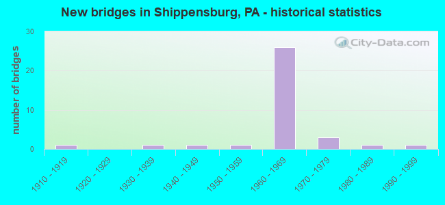
- New bridges - historical statistics
- 11910-1919
- 11930-1939
- 11940-1949
- 11950-1959
- 261960-1969
- 31970-1979
- 11980-1989
- 11990-1999

- Reconstructed bridges - Historical Statistics
- 21990-1999
- 22000-2009


- Bridge Condition - Deck
- 28.6%Good
- 50.0%Satisfactory
- 7.1%Fair
- 14.3%Poor

- Bridge Condition - Superstructure
- 46.7%Good
- 26.7%Satisfactory
- 20.0%Fair
- 6.7%Poor

- Bridge Condition - Substructure
- 13.3%Good
- 40.0%Satisfactory
- 46.7%Fair

- Bridge Condition - Channel
- 40.0%Good
- 60.0%Fair

- Bridge Condition - Culverts
- 16.7%Good
- 66.7%Satisfactory
- 16.7%Fair
Find on map >> Show street view
Structure Number: 13557, Location: SHIPPENSBURG (Lat: 40.049567, Lng: -77.523172), Route carried "on" structure: US 11, Year Built: 1911, Status: Open, Structure Length: 1.43m (4.69ft), Average Daily Traffic: 10,129 (year 2020), Truck Traffic: 7%, Average Future Daily Traffic: 19,430 (year 2032), Features Intersected: MIDDLE SPRING CREEK
Minimum Vertical Clearance: 30+ m (98+ ft), Kilometerpoint: 0.000, Lanes on structure: 2, Base Highway Network: Yes, Owner: State Highway Agency, Approaching Roadway Width: 14.3m (46.9ft), Skew: 3 degrees, Material/Design: Concrete, Design/Construction: Arch - Deck, Number Of Spans In Main Unit: 1, Length of Maximum Span: 12.2m (40.0ft), Curb or Sidewalk Widths: Left: 3.9m (12.8ft), Right: 3.6m (11.8ft), Curb-To-Curb Width: 14.4m (47.2ft), Out-to-Out Width: 22.6m (74.1ft)
Condition: Superstructure: Fair, Substructure: Fair, Channel: Fair, Operating Rating: 49.0 metric tons, Method Used To Determine Operating Rating: Field evaluation and documented engineering judgment, Inventory Rating: 32.7 metric tons, Method Used To Determine Inventory Rating: Field evaluation and documented engineering judgment, Structural Evaluation: Somewhat better than minimum adequacy, Deck Geometry: Superior to present desirable criteria, Waterway Adequacy: Better than present minimum criteria, Approach Roadway Alignment: Equal to present desirable criteria, Length Of Structure Improvement: 2.10m (6.89ft), Designated Inspection Frequency: Every 24 months, Inspection Date: January 2020, Bridge Improvement Cost: $35,000, Roadway Improvement Cost: $104,000, Total Project Cost: $475,000, Deck Structure Type: Concrete Cast-file-Place, Wearing Surface/Protective System: Wearing Surface: Bituminous
Find on map >> Show street view
Structure Number: 13558, Location: BORO OF SHIPPENSBURG (Lat: 40.059606, Lng: -77.506372), Route carried "on" structure: US 11, Year Built: 1940, Status: Open, Structure Length: 1.55m (5.09ft), Average Daily Traffic: 5,403 (year 2022), Truck Traffic: 13%, Average Future Daily Traffic: 8,326 (year 2032), Design Load: H 20, Features Intersected: BURDS RUN
Minimum Vertical Clearance: 30+ m (98+ ft), Kilometerpoint: 2.071, Lanes on structure: 2, Owner: State Highway Agency, Approaching Roadway Width: 12.8m (42.0ft), Skew: 4 degrees, Material/Design: Concrete, Design/Construction: Tee Beam, Number Of Spans In Main Unit: 1, Length of Maximum Span: 13.7m (44.9ft), Curb-To-Curb Width: 14.8m (48.6ft), Out-to-Out Width: 15.8m (51.8ft)
Condition: Deck: Poor, Superstructure: Poor, Substructure: Fair, Channel: Fair, Operating Rating: 54.4 metric tons, Method Used To Determine Operating Rating: Load Factor (LF), Inventory Rating: 32.7 metric tons, Method Used To Determine Inventory Rating: Load Factor (LF), Structural Evaluation: Meets minimum limits, Deck Geometry: Superior to present desirable criteria, Waterway Adequacy: Better than present minimum criteria, Approach Roadway Alignment: Equal to present desirable criteria, Length Of Structure Improvement: 2.20m (7.22ft), Designated Inspection Frequency: Every 24 months, Inspection Date: January 2020, Bridge Improvement Cost: $16,000, Roadway Improvement Cost: $46,000, Total Project Cost: $213,000, Deck Structure Type: Concrete Cast-file-Place, Wearing Surface/Protective System: Wearing Surface: Bituminous, Membrane: Preformed Fabric
Find on map >> Show street view
Structure Number: 13633, Location: 5 MI.S. EXIT 29 (Lat: 40.032672, Lng: -77.502392), Route carried "on" structure: Interstate 81, Year Built: 1963, Status: Open, Structure Length: 1.25m (4.10ft), Average Daily Traffic: 43,789 (year 2021), Truck Traffic: 37%, Average Future Daily Traffic: 48,062 (year 2032), Design Load: HS 20, Features Intersected: GUM RUN
Minimum Vertical Clearance: 30+ m (98+ ft), Kilometerpoint: 0.359, Lanes on structure: 4, Base Highway Network: Yes, Owner: State Highway Agency, Approaching Roadway Width: 39.0m (128.0ft), Skew: 24 degrees, Material/Design: Concrete, Design/Construction: Culvert, Number Of Spans In Main Unit: 2, Length of Maximum Span: 6.1m (20.0ft)
Condition: Channel: Good, Culverts: Satisfactory, Operating Rating: 56.2 metric tons, Method Used To Determine Operating Rating: Load Factor (LF), Inventory Rating: 33.6 metric tons, Method Used To Determine Inventory Rating: Load Factor (LF), Structural Evaluation: Equal to present minimum criteria, Waterway Adequacy: Equal to present minimum criteria, Approach Roadway Alignment: Equal to present desirable criteria, Length Of Structure Improvement: 1.90m (6.23ft), Designated Inspection Frequency: Every 24 months, Inspection Date: November 2019
Find on map >> Show street view
Structure Number: 13635, Location: 0.75 MI.S. OF EXIT 29 (Lat: 40.051853, Lng: -77.485439), Route carried "on" structure: Interstate 81, Year Built: 1963, Status: Open, Structure Length: 1.07m (3.51ft), Average Daily Traffic: 21,641 (year 2021), Truck Traffic: 38%, Average Future Daily Traffic: 24,363 (year 2032), Design Load: HS 20, Features Intersected: TWP RD (OLD SR 3003)TNBK
Minimum Vertical Clearance: 30+ m (98+ ft), Kilometerpoint: 2.775, Lanes on structure: 2, Lanes under structure: 2, Base Highway Network: Yes, Owner: State Highway Agency, Approaching Roadway Width: 12.2m (40.0ft), Skew: 10 degrees, Material/Design: Prestressed concrete, Design/Construction: Box Beam or Girders - Single/Spread, Number Of Spans In Main Unit: 1, Length of Maximum Span: 10.4m (34.1ft), Curb or Sidewalk Widths: Left: 0.2m (0.7ft), Right: 0.2m (0.7ft), Curb-To-Curb Width: 12.4m (40.7ft), Out-to-Out Width: 13.9m (45.6ft)
Condition: Deck: Satisfactory, Superstructure: Good, Substructure: Fair, Operating Rating: 68.9 metric tons, Method Used To Determine Operating Rating: Load Factor (LF), Inventory Rating: 36.3 metric tons, Method Used To Determine Inventory Rating: Load Factor (LF), Structural Evaluation: Somewhat better than minimum adequacy, Deck Geometry: Better than present minimum criteria, Underclear: Better than present minimum criteria, Approach Roadway Alignment: Equal to present desirable criteria, Length Of Structure Improvement: 1.80m (5.91ft), Designated Inspection Frequency: Every 24 months, Inspection Date: November 2019, Deck Structure Type: Concrete Cast-file-Place, Wearing Surface/Protective System: Wearing Surface: Bituminous
Find on map >> Show street view
Structure Number: 13636, Location: 0.75 MI.S. EXIT #10 (Lat: 40.052539, Lng: -77.484939), Route carried "on" structure: Interstate 81, Year Built: 1963, Status: Open, Structure Length: 1.46m (4.79ft), Average Daily Traffic: 43,789 (year 2021), Truck Traffic: 37%, Average Future Daily Traffic: 48,062 (year 2032), Design Load: HS 20, Features Intersected: BURD RUN
Minimum Vertical Clearance: 30+ m (98+ ft), Kilometerpoint: 2.775, Lanes on structure: 4, Base Highway Network: Yes, Owner: State Highway Agency, Approaching Roadway Width: 39.3m (128.9ft), Skew: 23 degrees, Material/Design: Concrete, Design/Construction: Culvert, Number Of Spans In Main Unit: 2, Length of Maximum Span: 7.0m (23.0ft)
Condition: Channel: Good, Culverts: Satisfactory, Operating Rating: 89.8 metric tons, Method Used To Determine Operating Rating: Load Factor (LF), Inventory Rating: 77.1 metric tons, Method Used To Determine Inventory Rating: Load Factor (LF), Structural Evaluation: Equal to present minimum criteria, Waterway Adequacy: Superior to present desirable criteria, Approach Roadway Alignment: Equal to present desirable criteria, Length Of Structure Improvement: 2.20m (7.22ft), Designated Inspection Frequency: Every 48 months, Inspection Date: November 2019
Find on map >> Show street view
Structure Number: 13637, Location: 0.75 MI.S. OF EXIT 29 (Lat: 40.051867, Lng: -77.485769), Route carried "on" structure: Interstate 81, Year Built: 1963, Status: Open, Structure Length: 1.07m (3.51ft), Average Daily Traffic: 22,148 (year 2021), Truck Traffic: 36%, Average Future Daily Traffic: 23,699 (year 2032), Design Load: HS 20, Features Intersected: TWP RD (OLD SR 3003)TNBK
Minimum Vertical Clearance: 30+ m (98+ ft), Kilometerpoint: 2.762, Lanes on structure: 2, Lanes under structure: 2, Base Highway Network: Yes, Owner: State Highway Agency, Approaching Roadway Width: 12.2m (40.0ft), Skew: 10 degrees, Material/Design: Prestressed concrete, Design/Construction: Box Beam or Girders - Single/Spread, Number Of Spans In Main Unit: 1, Length of Maximum Span: 10.4m (34.1ft), Curb or Sidewalk Widths: Left: 0.2m (0.7ft), Right: 0.2m (0.7ft), Curb-To-Curb Width: 12.4m (40.7ft), Out-to-Out Width: 13.9m (45.6ft)
Condition: Deck: Satisfactory, Superstructure: Satisfactory, Substructure: Fair, Operating Rating: 68.9 metric tons, Method Used To Determine Operating Rating: Load Factor (LF), Inventory Rating: 36.3 metric tons, Method Used To Determine Inventory Rating: Load Factor (LF), Structural Evaluation: Somewhat better than minimum adequacy, Deck Geometry: Better than present minimum criteria, Underclear: Superior to present desirable criteria, Approach Roadway Alignment: Equal to present desirable criteria, Length Of Structure Improvement: 1.80m (5.91ft), Designated Inspection Frequency: Every 24 months, Inspection Date: November 2019, Deck Structure Type: Concrete Cast-file-Place, Wearing Surface/Protective System: Wearing Surface: Bituminous
Find on map >> Show street view
Structure Number: 13638, Location: 1.0 MI.N. OF EXIT 29 (Lat: 40.069267, Lng: -77.464292), Route carried "on" structure: Interstate 81, Year Built: 1963, Status: Open, Structure Length: 1.01m (3.31ft), Average Daily Traffic: 21,441 (year 2021), Truck Traffic: 33%, Average Future Daily Traffic: 27,608 (year 2032), Design Load: HS 20, Features Intersected: GOODHART ROAD T-320
Minimum Vertical Clearance: 30+ m (98+ ft), Kilometerpoint: 6.003, Lanes on structure: 2, Lanes under structure: 2, Base Highway Network: Yes, Owner: State Highway Agency, Approaching Roadway Width: 12.2m (40.0ft), Skew: 10 degrees, Material/Design: Prestressed concrete, Design/Construction: Stringer/Multi-beam, Number Of Spans In Main Unit: 1, Length of Maximum Span: 9.8m (32.2ft), Curb or Sidewalk Widths: Left: 0.2m (0.7ft), Right: 0.2m (0.7ft), Curb-To-Curb Width: 12.4m (40.7ft), Out-to-Out Width: 13.9m (45.6ft)
Condition: Deck: Satisfactory, Superstructure: Satisfactory, Substructure: Satisfactory, Operating Rating: 85.3 metric tons, Method Used To Determine Operating Rating: Load Factor (LF), Inventory Rating: 47.2 metric tons, Method Used To Determine Inventory Rating: Load Factor (LF), Structural Evaluation: Equal to present minimum criteria, Deck Geometry: Better than present minimum criteria, Underclear: Somewhat better than minimum adequacy, Approach Roadway Alignment: Equal to present desirable criteria, Length Of Structure Improvement: 1.60m (5.25ft), Designated Inspection Frequency: Every 24 months, Inspection Date: November 2019, Deck Structure Type: Concrete Cast-file-Place, Wearing Surface/Protective System: Wearing Surface: Bituminous
Find on map >> Show street view
Structure Number: 13639, Location: 0.5 MI.N. OF EXIT 29 (Lat: 40.069425, Lng: -77.464525), Route carried "on" structure: Interstate 81, Year Built: 1963, Status: Open, Structure Length: 1.01m (3.31ft), Average Daily Traffic: 23,322 (year 2021), Truck Traffic: 29%, Average Future Daily Traffic: 27,085 (year 2032), Design Load: HS 20, Features Intersected: T-320 Goodhart
Minimum Vertical Clearance: 30+ m (98+ ft), Kilometerpoint: 6.011, Lanes on structure: 2, Lanes under structure: 2, Base Highway Network: Yes, Owner: State Highway Agency, Approaching Roadway Width: 12.2m (40.0ft), Skew: 10 degrees, Material/Design: Prestressed concrete, Design/Construction: Stringer/Multi-beam, Number Of Spans In Main Unit: 1, Length of Maximum Span: 9.8m (32.2ft), Curb or Sidewalk Widths: Left: 0.2m (0.7ft), Right: 0.2m (0.7ft), Curb-To-Curb Width: 12.4m (40.7ft), Out-to-Out Width: 13.9m (45.6ft)
Condition: Deck: Good, Superstructure: Good, Substructure: Satisfactory, Operating Rating: 85.3 metric tons, Method Used To Determine Operating Rating: Load Factor (LF), Inventory Rating: 47.2 metric tons, Method Used To Determine Inventory Rating: Load Factor (LF), Structural Evaluation: Equal to present minimum criteria, Deck Geometry: Better than present minimum criteria, Underclear: Equal to present minimum criteria, Approach Roadway Alignment: Equal to present desirable criteria, Length Of Structure Improvement: 1.60m (5.25ft), Designated Inspection Frequency: Every 48 months, Inspection Date: November 2019, Deck Structure Type: Concrete Cast-file-Place, Wearing Surface/Protective System: Wearing Surface: Bituminous
Find on map >> Show street view
Structure Number: 1364, Location: 1 MI N OF EXIT-10, I-29 (Lat: 40.076342, Lng: -77.449358), Route carried "on" structure: Interstate 81, Year Built: 1963, Status: Open, Structure Length: 1.10m (3.61ft), Average Daily Traffic: 21,441 (year 2021), Truck Traffic: 33%, Average Future Daily Traffic: 27,608 (year 2032), Design Load: HS 20, Features Intersected: SR 4003 KLINE RD.
Minimum Vertical Clearance: 30+ m (98+ ft), Kilometerpoint: 6.791, Lanes on structure: 2, Lanes under structure: 2, Base Highway Network: Yes, Owner: State Highway Agency, Approaching Roadway Width: 12.2m (40.0ft), Skew: 11 degrees, Material/Design: Prestressed concrete, Design/Construction: Stringer/Multi-beam, Number Of Spans In Main Unit: 1, Length of Maximum Span: 10.7m (35.1ft), Curb or Sidewalk Widths: Left: 0.2m (0.7ft), Right: 0.2m (0.7ft), Curb-To-Curb Width: 12.4m (40.7ft), Out-to-Out Width: 13.9m (45.6ft)
Condition: Deck: Satisfactory, Superstructure: Good, Substructure: Satisfactory, Operating Rating: 81.6 metric tons, Method Used To Determine Operating Rating: Load Factor (LF), Inventory Rating: 40.8 metric tons, Method Used To Determine Inventory Rating: Load Factor (LF), Structural Evaluation: Equal to present minimum criteria, Deck Geometry: Better than present minimum criteria, Underclear: Equal to present minimum criteria, Approach Roadway Alignment: Equal to present desirable criteria, Length Of Structure Improvement: 1.70m (5.58ft), Designated Inspection Frequency: Every 24 months, Inspection Date: November 2019, Bridge Improvement Cost: $10,000, Roadway Improvement Cost: $28,000, Total Project Cost: $129,000, Deck Structure Type: Concrete Cast-file-Place, Wearing Surface/Protective System: Wearing Surface: Bituminous
Find on map >> Show street view
Structure Number: 13641, Location: 1 MI N OF EXIT-10, I-81 (Lat: 40.076561, Lng: -77.449464), Route carried "on" structure: Interstate 81, Year Built: 1963, Status: Open, Structure Length: 1.10m (3.61ft), Average Daily Traffic: 23,322 (year 2021), Truck Traffic: 29%, Average Future Daily Traffic: 27,085 (year 2032), Design Load: HS 20, Features Intersected: SR 4003
Minimum Vertical Clearance: 30+ m (98+ ft), Kilometerpoint: 6.796, Lanes on structure: 2, Lanes under structure: 2, Base Highway Network: Yes, Owner: State Highway Agency, Approaching Roadway Width: 12.2m (40.0ft), Skew: 11 degrees, Material/Design: Prestressed concrete, Design/Construction: Stringer/Multi-beam, Number Of Spans In Main Unit: 1, Length of Maximum Span: 10.7m (35.1ft), Curb or Sidewalk Widths: Left: 0.2m (0.7ft), Right: 0.2m (0.7ft), Curb-To-Curb Width: 12.4m (40.7ft), Out-to-Out Width: 13.9m (45.6ft)
Condition: Deck: Satisfactory, Superstructure: Good, Substructure: Good, Operating Rating: 81.6 metric tons, Method Used To Determine Operating Rating: Load Factor (LF), Inventory Rating: 40.8 metric tons, Method Used To Determine Inventory Rating: Load Factor (LF), Structural Evaluation: Better than present minimum criteria, Deck Geometry: Better than present minimum criteria, Underclear: Somewhat better than minimum adequacy, Approach Roadway Alignment: Equal to present desirable criteria, Length Of Structure Improvement: 1.70m (5.58ft), Designated Inspection Frequency: Every 24 months, Inspection Date: November 2019, Deck Structure Type: Concrete Cast-file-Place, Wearing Surface/Protective System: Wearing Surface: Bituminous
Find on map >> Show street view
Structure Number: 13727, Location: 1.5 MI.E. OF SHIPPENSBURG (Lat: 40.060442, Lng: -77.479378), Route carried "on" structure: State highway 174, Year Built: 1963, Year Reconstructed: 1990, Status: Open, Structure Length: 5.70m (18.70ft), Average Daily Traffic: 5,740 (year 2022), Truck Traffic: 19%, Average Future Daily Traffic: 6,724 (year 2032), Design Load: HS 20, Features Intersected: I-81; SR 0081
Minimum Vertical Clearance: 30+ m (98+ ft), Kilometerpoint: 2.189, Lanes on structure: 2, Lanes under structure: 8, Base Highway Network: Yes, Owner: State Highway Agency, Approaching Roadway Width: 12.2m (40.0ft), Skew: 4 degrees, Material/Design: Steel, Design/Construction: Stringer/Multi-beam, Number Of Spans In Main Unit: 2, Length of Maximum Span: 26.8m (87.9ft), Curb or Sidewalk Widths: Left: 0.2m (0.7ft), Right: 0.2m (0.7ft), Curb-To-Curb Width: 10.4m (34.1ft), Out-to-Out Width: 11.4m (37.4ft)
Condition: Deck: Good, Superstructure: Good, Substructure: Good, Operating Rating: 88.9 metric tons, Method Used To Determine Operating Rating: Load Factor (LF), Inventory Rating: 53.5 metric tons, Method Used To Determine Inventory Rating: Load Factor (LF), Structural Evaluation: Better than present minimum criteria, Deck Geometry: Meets minimum limits, Underclear: Somewhat better than minimum adequacy, Approach Roadway Alignment: Equal to present desirable criteria, Length Of Structure Improvement: 6.70m (21.98ft), Designated Inspection Frequency: Every 24 months, Inspection Date: January 2020, Bridge Improvement Cost: $36,000, Roadway Improvement Cost: $106,000, Total Project Cost: $485,000, Deck Structure Type: Concrete Cast-file-Place, Wearing Surface/Protective System: Wearing Surface: Latex Concrete, Deck Protection: Epoxy Coated Reinforcing
Find on map >> Show street view
Structure Number: 13783, Location: SHIPPENSBURG (Lat: 40.040172, Lng: -77.519219), Route carried "on" structure: State highway 696, Year Built: 1965, Status: Open, Structure Length: 0.85m (2.79ft), Average Daily Traffic: 8,211 (year 2020), Truck Traffic: 13%, Average Future Daily Traffic: 11,417 (year 2032), Design Load: HS 20, Features Intersected: SHIRLEYS RUN
Minimum Vertical Clearance: 30+ m (98+ ft), Kilometerpoint: 0.000, Lanes on structure: 2, Owner: State Highway Agency, Approaching Roadway Width: 8.5m (27.9ft), Skew: 3 degrees, Material/Design: Concrete, Design/Construction: Culvert, Number Of Spans In Main Unit: 1, Length of Maximum Span: 7.6m (24.9ft), Curb or Sidewalk Widths: Left: 0.5m (1.6ft), Right: 0.5m (1.6ft), Curb-To-Curb Width: 12.2m (40.0ft), Out-to-Out Width: 13.9m (45.6ft)
Condition: Channel: Good, Culverts: Good, Operating Rating: 49.0 metric tons, Method Used To Determine Operating Rating: Field evaluation and documented engineering judgment, Inventory Rating: 32.7 metric tons, Method Used To Determine Inventory Rating: Field evaluation and documented engineering judgment, Structural Evaluation: Better than present minimum criteria, Deck Geometry: Somewhat better than minimum adequacy, Waterway Adequacy: Equal to present minimum criteria, Approach Roadway Alignment: Equal to present desirable criteria, Length Of Structure Improvement: 1.50m (4.92ft), Designated Inspection Frequency: Every 24 months, Inspection Date: November 2019
Find on map >> Show street view
Structure Number: 13906, Location: AT SHIPPENSBURG (Lat: 40.049694, Lng: -77.506092), Route carried "on" structure: State highway , Year Built: 1986, Status: Open, Structure Length: 2.01m (6.59ft), Average Daily Traffic: 5,148 (year 2022), Truck Traffic: 4%, Average Future Daily Traffic: 6,203 (year 2032), Design Load: HS 25 or greater, Features Intersected: NORFOLK SO. R.R., Facility Carried by Structure: SR 3001
Minimum Vertical Clearance: 30+ m (98+ ft), Kilometerpoint: 12.994, Lanes on structure: 2, Owner: State Highway Agency, Approaching Roadway Width: 10.4m (34.1ft), Skew: 3 degrees, Material/Design: Prestressed concrete, Design/Construction: Box Beam or Girders - Multiple, Number Of Spans In Main Unit: 1, Length of Maximum Span: 18.9m (62.0ft), Curb or Sidewalk Widths: Left: 0.2m (0.7ft), Right: 0.2m (0.7ft), Curb-To-Curb Width: 10.4m (34.1ft), Out-to-Out Width: 11.5m (37.7ft)
Condition: Deck: Satisfactory, Superstructure: Good, Substructure: Fair, Inventory Rating: 45.4 metric tons, Method Used To Determine Inventory Rating: Load Factor (LF), Structural Evaluation: Somewhat better than minimum adequacy, Deck Geometry: Meets minimum limits, Underclear: High priority of corrective action, Approach Roadway Alignment: Better than present minimum criteria, Length Of Structure Improvement: 2.70m (8.86ft), Designated Inspection Frequency: Every 24 months, Inspection Date: November 2019, Deck Structure Type: Concrete Cast-file-Place, Wearing Surface/Protective System: Wearing Surface: Monolithic Concrete, Deck Protection: Epoxy Coated Reinforcing
Find on map >> Show street view
Structure Number: 14087, Location: .7NNW US11 & 696/MIDSPRIN (Lat: 40.056867, Lng: -77.528925), Route carried "on" structure: City street , Year Built: 1973, Status: Open, Structure Length: 1.04m (3.41ft), Average Daily Traffic: 200 (year 2021), Truck Traffic: 3%, Average Future Daily Traffic: 280 (year 2041), Features Intersected: MIDDLE SPRING CREEK, Facility Carried by Structure: HOT POINT AVE,T303
Minimum Vertical Clearance: 7.62m (25.00ft), Kilometerpoint: 0.000, Lanes on structure: 2, Owner: Town or Township Highway Agency, Approaching Roadway Width: 7.3m (24.0ft), Skew: 1 degrees, Material/Design: Concrete, Design/Construction: Culvert, Number Of Spans In Main Unit: 2, Length of Maximum Span: 4.6m (15.1ft), Curb-To-Curb Width: 7.4m (24.3ft), Out-to-Out Width: 8.4m (27.6ft)
Condition: Channel: Fair, Culverts: Satisfactory, Operating Rating: 34.5 metric tons, Method Used To Determine Operating Rating: Field evaluation and documented engineering judgment, Inventory Rating: 29.0 metric tons, Method Used To Determine Inventory Rating: Field evaluation and documented engineering judgment, Structural Evaluation: Equal to present minimum criteria, Deck Geometry: Somewhat better than minimum adequacy, Waterway Adequacy: Better than present minimum criteria, Approach Roadway Alignment: Equal to present desirable criteria, Length Of Structure Improvement: 1.70m (5.58ft), Designated Inspection Frequency: Every 24 months, Inspection Date: June 2021, Wearing Surface/Protective System: Wearing Surface: Bituminous
Find on map >> Show street view
Structure Number: 14124, Location: .3 MI.NW US 11 & PA 696 (Lat: 40.052964, Lng: -77.525194), Route carried "on" structure: City street , Year Built: 1973, Status: Open, Structure Length: 1.01m (3.31ft), Average Daily Traffic: 1,800 (year 2021), Truck Traffic: 3%, Average Future Daily Traffic: 2,520 (year 2041), Design Load: HS 20, Features Intersected: MIDDLE SPRING CREEK, Facility Carried by Structure: SPRING HOUSE ROAD
Minimum Vertical Clearance: 30+ m (98+ ft), Kilometerpoint: 0.000, Lanes on structure: 2, Owner: City or Municipal Highway Agency, Approaching Roadway Width: 9.1m (29.9ft), Material/Design: Concrete, Design/Construction: Culvert, Number Of Spans In Main Unit: 2, Length of Maximum Span: 4.6m (15.1ft), Curb or Sidewalk Widths: Left: 1.2m (3.9ft), Right: 1.2m (3.9ft), Curb-To-Curb Width: 9.1m (29.9ft), Out-to-Out Width: 12.2m (40.0ft)
Condition: Channel: Fair, Culverts: Satisfactory, Operating Rating: 39.0 metric tons, Method Used To Determine Operating Rating: Field evaluation and documented engineering judgment, Inventory Rating: 32.7 metric tons, Method Used To Determine Inventory Rating: Field evaluation and documented engineering judgment, Structural Evaluation: Equal to present minimum criteria, Deck Geometry: Somewhat better than minimum adequacy, Waterway Adequacy: Better than present minimum criteria, Approach Roadway Alignment: Equal to present desirable criteria, Length Of Structure Improvement: 1.60m (5.25ft), Designated Inspection Frequency: Every 24 months, Inspection Date: June 2021, Wearing Surface/Protective System: Wearing Surface: Monolithic Concrete
Find on map >> Show street view
Structure Number: 14126, Location: 0.1 M SW OF US 11/PA 696 (Lat: 40.048356, Lng: -77.521639), Route carried "on" structure: City street , Year Built: 1977, Year Reconstructed: 1999, Status: Open, Structure Length: 0.94m (3.08ft), Average Daily Traffic: 5,000 (year 2019), Truck Traffic: 3%, Average Future Daily Traffic: 7,000 (year 2039), Design Load: HS 25 or greater, Features Intersected: MIDDLE SPRING CREEK, Facility Carried by Structure: WEST ORANGE STREET
Minimum Vertical Clearance: 30+ m (98+ ft), Kilometerpoint: 0.000, Lanes on structure: 2, Owner: City or Municipal Highway Agency, Approaching Roadway Width: 12.2m (40.0ft), Skew: 3 degrees, Material/Design: Prestressed concrete, Design/Construction: Box Beam or Girders - Multiple, Number Of Spans In Main Unit: 1, Length of Maximum Span: 8.5m (27.9ft), Curb or Sidewalk Widths: Left: 2.0m (6.6ft), Right: 2.1m (6.9ft), Curb-To-Curb Width: 12.2m (40.0ft), Out-to-Out Width: 16.5m (54.1ft)
Condition: Deck: Satisfactory, Superstructure: Satisfactory, Substructure: Satisfactory, Channel: Fair, Operating Rating: 47.2 metric tons, Method Used To Determine Operating Rating: Load Factor (LF), Inventory Rating: 28.1 metric tons, Method Used To Determine Inventory Rating: Load Factor (LF), Structural Evaluation: Equal to present minimum criteria, Deck Geometry: Equal to present minimum criteria, Waterway Adequacy: Better than present minimum criteria, Approach Roadway Alignment: Equal to present desirable criteria, Length Of Structure Improvement: 1.10m (3.61ft), Designated Inspection Frequency: Every 24 months, Inspection Date: June 2021, Bridge Improvement Cost: $7,000, Roadway Improvement Cost: $22,000, Total Project Cost: $99,000, Deck Structure Type: Closed Grating, Wearing Surface/Protective System: Wearing Surface: Bituminous
Find on map >> Show street view
Structure Number: 14127, Location: .2 MI. NW US 11 & PA 696 (Lat: 40.051106, Lng: -77.524183), Route carried "on" structure: City street , Year Built: 1993, Status: Open, Structure Length: 1.04m (3.41ft), Average Daily Traffic: 4,000 (year 2021), Truck Traffic: 3%, Average Future Daily Traffic: 5,600 (year 2041), Design Load: HS 20, Features Intersected: MIDDLE SPRING CREEK, Facility Carried by Structure: WEST BURD STREET
Minimum Vertical Clearance: 30+ m (98+ ft), Kilometerpoint: 0.000, Lanes on structure: 2, Owner: City or Municipal Highway Agency, Approaching Roadway Width: 9.1m (29.9ft), Material/Design: Concrete, Design/Construction: Culvert, Number Of Spans In Main Unit: 1, Length of Maximum Span: 10.1m (33.1ft), Curb or Sidewalk Widths: Left: 1.5m (4.9ft), Right: 1.5m (4.9ft), Curb-To-Curb Width: 9.2m (30.2ft), Out-to-Out Width: 12.7m (41.7ft)
Condition: Channel: Fair, Culverts: Fair, Operating Rating: 49.9 metric tons, Method Used To Determine Operating Rating: Load Factor (LF), Inventory Rating: 29.9 metric tons, Method Used To Determine Inventory Rating: Load Factor (LF), Structural Evaluation: Somewhat better than minimum adequacy, Deck Geometry: Meets minimum limits, Waterway Adequacy: Better than present minimum criteria, Approach Roadway Alignment: Equal to present desirable criteria, Length Of Structure Improvement: 1.70m (5.58ft), Designated Inspection Frequency: Every 24 months, Inspection Date: June 2021, Wearing Surface/Protective System: Wearing Surface: Bituminous, Deck Protection: Epoxy Coated Reinforcing
Find on map >> Show street view
Structure Number: 17293, Location: SHIPPENSBURG (Lat: 40.043797, Lng: -77.533400), Route carried "on" structure: US 11, Year Built: 1937, Status: Open, Structure Length: 1.80m (5.91ft), Average Daily Traffic: 9,393 (year 2022), Truck Traffic: 7%, Average Future Daily Traffic: 13,370 (year 2032), Design Load: H 20, Features Intersected: Norfolk Southern RR
Minimum Vertical Clearance: 30+ m (98+ ft), Kilometerpoint: 42.054, Lanes on structure: 3, Base Highway Network: Yes, Owner: Railroad, Approaching Roadway Width: 14.9m (48.9ft), Skew: 4 degrees, Material/Design: Steel, Design/Construction: Stringer/Multi-beam, Number Of Spans In Main Unit: 1, Length of Maximum Span: 17.7m (58.1ft), Curb or Sidewalk Widths: Left: 1.5m (4.9ft), Right: 0.2m (0.7ft), Curb-To-Curb Width: 13.4m (44.0ft), Out-to-Out Width: 15.8m (51.8ft)
Condition: Deck: Poor, Superstructure: Fair, Substructure: Fair, Inventory Rating: 62.6 metric tons, Method Used To Determine Inventory Rating: Load Factor (LF), Structural Evaluation: Somewhat better than minimum adequacy, Deck Geometry: Somewhat better than minimum adequacy, Underclear: High priority of replacement, Approach Roadway Alignment: Equal to present desirable criteria, Length Of Structure Improvement: 2.20m (7.22ft), Designated Inspection Frequency: Every 24 months, Inspection Date: November 2019, Bridge Improvement Cost: $54,000, Roadway Improvement Cost: $160,000, Total Project Cost: $734,000, Deck Structure Type: Concrete Cast-file-Place, Wearing Surface/Protective System: Wearing Surface: Bituminous
Find on map >> Show street view
Structure Number: 17444, Location: 2.25 M S SHIPPENSBURG (Lat: 40.015200, Lng: -77.533631), Route carried "on" structure: State highway 696, Year Built: 1963, Year Reconstructed: 2011, Status: Open, Structure Length: 7.99m (26.21ft), Average Daily Traffic: 8,211 (year 2020), Truck Traffic: 13%, Average Future Daily Traffic: 11,406 (year 2032), Design Load: HS 20, Features Intersected: I-81; SR 0081
Minimum Vertical Clearance: 30+ m (98+ ft), Kilometerpoint: 6.676, Lanes on structure: 2, Lanes under structure: 4, Base Highway Network: Yes, Owner: State Highway Agency, Approaching Roadway Width: 10.1m (33.1ft), Skew: 4 degrees, Material/Design: Prestressed concrete, Design/Construction: Stringer/Multi-beam, Number Of Spans In Main Unit: 4, Length of Maximum Span: 26.2m (86.0ft), Curb or Sidewalk Widths: Left: 0.2m (0.7ft), Right: 0.2m (0.7ft), Curb-To-Curb Width: 9.8m (32.2ft), Out-to-Out Width: 10.7m (35.1ft)
Condition: Deck: Good, Superstructure: Satisfactory, Substructure: Fair, Operating Rating: 70.8 metric tons, Method Used To Determine Operating Rating: Load Factor (LF), Inventory Rating: 29.0 metric tons, Method Used To Determine Inventory Rating: Load Factor (LF), Structural Evaluation: Somewhat better than minimum adequacy, Deck Geometry: Meets minimum limits, Underclear: Equal to present minimum criteria, Approach Roadway Alignment: Better than present minimum criteria, Length Of Structure Improvement: 8.00m (26.25ft), Designated Inspection Frequency: Every 24 months, Inspection Date: June 2020, Bridge Improvement Cost: $100,000, Roadway Improvement Cost: $294,000, Total Project Cost: $1,349,000, Deck Structure Type: Concrete Cast-file-Place, Wearing Surface/Protective System: Wearing Surface: Monolithic Concrete, Deck Protection: Epoxy Coated Reinforcing
Find on map >> Show street view
Structure Number: 17445, Location: .75 MI.S.E. SHIPPENSBURG (Lat: 40.042725, Lng: -77.519022), Route carried "on" structure: State highway 696, Year Built: 1954, Status: Open, Structure Length: 0.70m (2.30ft), Average Daily Traffic: 7,006 (year 2020), Truck Traffic: 6%, Average Future Daily Traffic: 11,999 (year 2032), Design Load: HS 20, Features Intersected: SHIRLEY RUN
Minimum Vertical Clearance: 30+ m (98+ ft), Kilometerpoint: 10.200, Lanes on structure: 2, Base Highway Network: Yes, Owner: State Highway Agency, Approaching Roadway Width: 8.5m (27.9ft), Skew: 3 degrees, Material/Design: Prestressed concrete, Design/Construction: Box Beam or Girders - Multiple, Number Of Spans In Main Unit: 1, Length of Maximum Span: 6.1m (20.0ft), Curb-To-Curb Width: 9.6m (31.5ft), Out-to-Out Width: 10.2m (33.5ft)
Condition: Deck: Fair, Superstructure: Fair, Substructure: Satisfactory, Channel: Good, Operating Rating: 74.4 metric tons, Method Used To Determine Operating Rating: Load Factor (LF), Inventory Rating: 44.5 metric tons, Method Used To Determine Inventory Rating: Load Factor (LF), Structural Evaluation: Somewhat better than minimum adequacy, Deck Geometry: High priority of corrective action, Waterway Adequacy: Equal to present minimum criteria, Approach Roadway Alignment: Equal to present desirable criteria, Length Of Structure Improvement: 1.30m (4.27ft), Designated Inspection Frequency: Every 24 months, Inspection Date: June 2020, Deck Structure Type: Other, Wearing Surface/Protective System: Wearing Surface: Bituminous
Find on map >> Show street view
Structure Number: 17489, Location: 1 MI.S. SHIPPENSBURG (Lat: 40.024275, Lng: -77.516261), Route carried "on" structure: State highway , Year Built: 1963, Year Reconstructed: 2000, Status: Open, Structure Length: 7.38m (24.21ft), Average Daily Traffic: 1,463 (year 2022), Truck Traffic: 9%, Average Future Daily Traffic: 1,428 (year 2032), Design Load: HS 20, Features Intersected: I-81; SR 0081, Facility Carried by Structure: SR 1005
Minimum Vertical Clearance: 30+ m (98+ ft), Kilometerpoint: 2.285, Lanes on structure: 2, Lanes under structure: 4, Owner: State Highway Agency, Approaching Roadway Width: 9.8m (32.2ft), Skew: 3 degrees, Material/Design: Prestressed concrete, Design/Construction: Stringer/Multi-beam, Number Of Spans In Main Unit: 4, Length of Maximum Span: 23.8m (78.1ft), Curb or Sidewalk Widths: Left: 0.2m (0.7ft), Right: 0.2m (0.7ft), Curb-To-Curb Width: 10.0m (32.8ft), Out-to-Out Width: 10.9m (35.8ft)
Condition: Deck: Good, Superstructure: Good, Substructure: Satisfactory, Operating Rating: 61.7 metric tons, Method Used To Determine Operating Rating: Load Factor (LF), Inventory Rating: 23.6 metric tons, Method Used To Determine Inventory Rating: Load Factor (LF), Structural Evaluation: Equal to present minimum criteria, Deck Geometry: Somewhat better than minimum adequacy, Underclear: Equal to present desirable criteria, Approach Roadway Alignment: Equal to present desirable criteria, Length Of Structure Improvement: 8.30m (27.23ft), Designated Inspection Frequency: Every 24 months, Inspection Date: July 2020, Deck Structure Type: Concrete Cast-file-Place, Wearing Surface/Protective System: Wearing Surface: Monolithic Concrete, Deck Protection: Epoxy Coated Reinforcing
Find on map >> Show street view
Structure Number: 13635, Location: 0.75 MI.S. OF EXIT 29 (Lat: 40.051853, Lng: -77.485439), Route carried "under" structure: City street , Year Built: 1963, Structure Length: 0. m, Average Daily Traffic: 1,237 (year 1993), Truck Traffic: 9%, Features Intersected: TWP RD (OLD SR 3003)TNBK, Facility Carried by Structure: I-81; SR 0081
Minimum Vertical Clearance: 4.95m (16.24ft), Kilometerpoint: 0.000, Lanes on structure: 2, Lanes under structure: 2, Material/Design: Prestressed concrete, Design/Construction: Box Beam or Girders - Single/Spread, Length of Maximum Span: 10.4m (34.1ft)
Find on map >> Show street view
Structure Number: 13637, Location: 0.75 MI.S. OF EXIT 29 (Lat: 40.051867, Lng: -77.485769), Route carried "under" structure: State highway , Year Built: 1963, Structure Length: 0. m, Average Daily Traffic: 1,151 (year 1991), Truck Traffic: 13%, Features Intersected: TWP RD (OLD SR 3003)TNBK, Facility Carried by Structure: I-81 SB; SR 0081
Minimum Vertical Clearance: 5.51m (18.08ft), Kilometerpoint: 0.000, Lanes on structure: 2, Lanes under structure: 2, Material/Design: Prestressed concrete, Design/Construction: Box Beam or Girders - Single/Spread, Length of Maximum Span: 10.4m (34.1ft)
Find on map >> Show street view
Structure Number: 13638, Location: 1.0 MI.N. OF EXIT 29 (Lat: 40.069267, Lng: -77.464292), Route carried "under" structure: City street , Year Built: 1963, Structure Length: 0. m, Average Daily Traffic: 500 (year 1978), Truck Traffic: 2%, Features Intersected: GOODHART ROAD T-320, Facility Carried by Structure: I-81 NB; SR 0081
Minimum Vertical Clearance: 4.34m (14.24ft), Kilometerpoint: 0.000, Lanes on structure: 2, Lanes under structure: 2, Material/Design: Prestressed concrete, Design/Construction: Stringer/Multi-beam, Length of Maximum Span: 9.8m (32.2ft)
Find on map >> Show street view
Structure Number: 13639, Location: 0.5 MI.N. OF EXIT 29 (Lat: 40.069425, Lng: -77.464525), Route carried "under" structure: City street , Year Built: 1963, Structure Length: 0. m, Average Daily Traffic: 500 (year 1978), Truck Traffic: 2%, Features Intersected: T-320 Goodhart, Facility Carried by Structure: I-81 SB; SR 0081
Minimum Vertical Clearance: 4.62m (15.16ft), Kilometerpoint: 0.000, Lanes on structure: 2, Lanes under structure: 2, Material/Design: Prestressed concrete, Design/Construction: Stringer/Multi-beam, Length of Maximum Span: 9.8m (32.2ft)
Find on map >> Show street view
Structure Number: 1364, Location: 1 MI N OF EXIT-10, I-29 (Lat: 40.076342, Lng: -77.449358), Route carried "under" structure: State highway , Year Built: 1963, Structure Length: 0. m, Average Daily Traffic: 682 (year 2022), Truck Traffic: 22%, Features Intersected: SR 4003 KLINE RD., Facility Carried by Structure: I-81 NB; SR 0081
Minimum Vertical Clearance: 4.60m (15.09ft), Kilometerpoint: 0.867, Lanes on structure: 2, Lanes under structure: 2, Material/Design: Prestressed concrete, Design/Construction: Stringer/Multi-beam, Length of Maximum Span: 10.7m (35.1ft)
Find on map >> Show street view
Structure Number: 13641, Location: 1 MI N OF EXIT-10, I-81 (Lat: 40.076561, Lng: -77.449464), Route carried "under" structure: State highway , Year Built: 1963, Structure Length: 0. m, Average Daily Traffic: 682 (year 2022), Truck Traffic: 22%, Features Intersected: SR 4003, Facility Carried by Structure: I-81 SB; SR 0081
Minimum Vertical Clearance: 4.52m (14.83ft), Kilometerpoint: 0.867, Lanes on structure: 2, Lanes under structure: 2, Material/Design: Prestressed concrete, Design/Construction: Stringer/Multi-beam, Length of Maximum Span: 10.7m (35.1ft)
Find on map >> Show street view
Structure Number: 13727, Location: 1.5 MI.E. OF SHIPPENSBURG (Lat: 40.060442, Lng: -77.479378), Route carried "under" structure: Interstate 81, Year Built: 1963, Structure Length: 0. m, Average Daily Traffic: 23,322 (year 2021), Truck Traffic: 29%, Features Intersected: I-81; SR 0081, Facility Carried by Structure: PA 174; SR 0174
Minimum Vertical Clearance: 4.98m (16.34ft), Kilometerpoint: 4.365, Lanes on structure: 2, Lanes under structure: 4, Material/Design: Steel, Design/Construction: Stringer/Multi-beam, Length of Maximum Span: 26.8m (87.9ft)
Find on map >> Show street view
Structure Number: 13727, Location: 1.5 MI.E. OF SHIPPENSBURG (Lat: 40.060442, Lng: -77.479378), Route carried "under" structure: Interstate 81, Year Built: 1963, Structure Length: 0. m, Average Daily Traffic: 21,441 (year 2021), Truck Traffic: 33%, Features Intersected: I-81; SR 0081, Facility Carried by Structure: PA 174; SR 0174
Minimum Vertical Clearance: 4.95m (16.24ft), Kilometerpoint: 4.371, Lanes on structure: 2, Lanes under structure: 4, Material/Design: Steel, Design/Construction: Stringer/Multi-beam, Length of Maximum Span: 26.8m (87.9ft)
Find on map >> Show street view
Structure Number: 13905, Location: 1.75 MI.S. OF EXIT 10 (Lat: 40.040789, Lng: -77.493661), Route carried "under" structure: Interstate 81, Year Built: 1963, Structure Length: 0. m, Average Daily Traffic: 21,641 (year 2021), Truck Traffic: 38%, Features Intersected: I-81; SR 0081, Facility Carried by Structure: SR 3001 BALT.RD.
Minimum Vertical Clearance: 5.08m (16.67ft), Kilometerpoint: 1.141, Lanes on structure: 2, Lanes under structure: 4, Material/Design: Prestressed concrete, Design/Construction: Stringer/Multi-beam, Length of Maximum Span: 19.8m (65.0ft)
Find on map >> Show street view
Structure Number: 13905, Location: 1.75 MI.S. OF EXIT 10 (Lat: 40.040789, Lng: -77.493661), Route carried "under" structure: Interstate 81, Year Built: 1963, Structure Length: 0. m, Average Daily Traffic: 22,148 (year 2021), Truck Traffic: 36%, Features Intersected: I-81; SR 0081, Facility Carried by Structure: SR 3001 BALT.RD.
Minimum Vertical Clearance: 5.08m (16.67ft), Kilometerpoint: 1.131, Lanes on structure: 2, Lanes under structure: 4, Material/Design: Prestressed concrete, Design/Construction: Stringer/Multi-beam, Length of Maximum Span: 19.8m (65.0ft)
Find on map >> Show street view
Structure Number: 17444, Location: 2.25 M S SHIPPENSBURG (Lat: 40.015200, Lng: -77.533631), Route carried "under" structure: Interstate 81, Year Built: 1963, Structure Length: 0. m, Average Daily Traffic: 21,641 (year 2021), Truck Traffic: 38%, Features Intersected: I-81; SR 0081, Facility Carried by Structure: PA 696; Olde scotl
Minimum Vertical Clearance: 5.03m (16.50ft), Kilometerpoint: 38.631, Lanes on structure: 2, Lanes under structure: 4, Material/Design: Prestressed concrete, Design/Construction: Stringer/Multi-beam, Length of Maximum Span: 26.2m (86.0ft)
Find on map >> Show street view
Structure Number: 17444, Location: 2.25 M S SHIPPENSBURG (Lat: 40.015200, Lng: -77.533631), Route carried "under" structure: Interstate 81, Year Built: 1963, Structure Length: 0. m, Average Daily Traffic: 22,148 (year 2021), Truck Traffic: 36%, Features Intersected: I-81; SR 0081, Facility Carried by Structure: PA 696; Olde scotl
Minimum Vertical Clearance: 5.03m (16.50ft), Kilometerpoint: 38.673, Lanes on structure: 2, Lanes under structure: 4, Material/Design: Prestressed concrete, Design/Construction: Stringer/Multi-beam, Length of Maximum Span: 26.2m (86.0ft)
Find on map >> Show street view
Structure Number: 17489, Location: 1 MI.S. SHIPPENSBURG (Lat: 40.024275, Lng: -77.516261), Route carried "under" structure: Interstate 81, Year Built: 1963, Structure Length: 0. m, Average Daily Traffic: 21,641 (year 2021), Truck Traffic: 38%, Features Intersected: I-81; SR 0081, Facility Carried by Structure: SR 1005
Minimum Vertical Clearance: 5.18m (16.99ft), Kilometerpoint: 40.267, Lanes on structure: 2, Lanes under structure: 4, Material/Design: Prestressed concrete, Design/Construction: Stringer/Multi-beam, Length of Maximum Span: 23.8m (78.1ft)
Find on map >> Show street view
Structure Number: 17489, Location: 1 MI.S. SHIPPENSBURG (Lat: 40.024275, Lng: -77.516261), Route carried "under" structure: Interstate 81, Year Built: 1963, Structure Length: 0. m, Average Daily Traffic: 22,148 (year 2021), Truck Traffic: 36%, Features Intersected: I-81; SR 0081, Facility Carried by Structure: SR 1005
Minimum Vertical Clearance: 5.18m (16.99ft), Kilometerpoint: 40.272, Lanes on structure: 2, Lanes under structure: 4, Material/Design: Prestressed concrete, Design/Construction: Stringer/Multi-beam, Length of Maximum Span: 23.8m (78.1ft)