Bridge Statistics for Sherman, Wisconsin (WI)
Condition, Traffic, Stress, Structural Evaluation, Project Costs
- National Bridge Inventory (NBI) Statistics
- 10Number of bridges
- 46ft / 14.2mTotal length
- 4,319Total average daily traffic
- 227Total average daily truck traffic
- 4,553Total future (year 2039) average daily traffic
- National Bridge Inventory (NBI) Registered Bridges for Sherman
- No street view available for this location
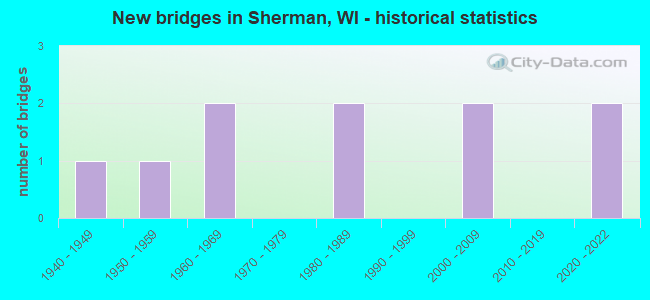
- New bridges - historical statistics
- 11940-1949
- 11950-1959
- 21960-1969
- 21980-1989
- 22000-2009
- 22020-2022

- Bridge Condition - Deck
- 25.0%Excellent
- 12.5%Very good
- 12.5%Good
- 50.0%Satisfactory

- Bridge Condition - Superstructure
- 25.0%Excellent
- 12.5%Very good
- 25.0%Good
- 12.5%Satisfactory
- 25.0%Fair

- Bridge Condition - Substructure
- 25.0%Excellent
- 12.5%Very good
- 50.0%Good
- 12.5%Satisfactory

- Bridge Condition - Channel
- 30.0%Excellent
- 20.0%Very good
- 10.0%Good
- 40.0%Satisfactory
Find on map >> Show street view
Structure Number: B590109, Location: 0.3M E JCT CTH I (Lat: 43.557258, Lng: -87.974650), Route carried "on" structure: State highway 144, Year Built: 1981, Status: Open, Structure Length: 0.86m (2.82ft), Average Daily Traffic: 1,900 (year 2020), Truck Traffic: 10%, Average Future Daily Traffic: 1,900 (year 2039), Design Load: HS 20, Features Intersected: SILVER CREEK
Minimum Vertical Clearance: 30+ m (98+ ft), Kilometerpoint: 0.000, Lanes on structure: 2, Owner: State Highway Agency, Approaching Roadway Width: 9.1m (29.9ft), Skew: 4 degrees, Material/Design: Concrete continuous, Design/Construction: Culvert, Number Of Spans In Main Unit: 2, Length of Maximum Span: 2.7m (8.9ft)
Condition: Channel: Very good, Culverts: Good, Operating Rating: 53.9 metric tons, Method Used To Determine Operating Rating: Field evaluation and documented engineering judgment, Inventory Rating: 32.4 metric tons, Method Used To Determine Inventory Rating: Field evaluation and documented engineering judgment, Structural Evaluation: Better than present minimum criteria, Waterway Adequacy: Equal to present desirable criteria, Approach Roadway Alignment: Equal to present desirable criteria, Designated Inspection Frequency: Every 48 months, Inspection Date: June 2020, Deck Structure Type: Concrete Cast-file-Place, Wearing Surface/Protective System: Wearing Surface: Bituminous
Find on map >> Show street view
Structure Number: B590129, Location: 0.2M S JCT STH 144 (Lat: 43.555169, Lng: -87.980983), Route carried "on" structure: County highway , Year Built: 1986, Status: Open, Structure Length: 1.16m (3.81ft), Average Daily Traffic: 596 (year 2019), Average Future Daily Traffic: 655 (year 2040), Design Load: HS 20, Features Intersected: SILVER CREEK, Facility Carried by Structure: CTH I
Minimum Vertical Clearance: 30+ m (98+ ft), Kilometerpoint: 0.000, Lanes on structure: 2, Owner: County Highway Agency, Approaching Roadway Width: 8.5m (27.9ft), Skew: 4 degrees, Material/Design: Concrete, Design/Construction: Culvert, Number Of Spans In Main Unit: 2, Length of Maximum Span: 3.7m (12.1ft)
Condition: Channel: Satisfactory, Culverts: Good, Operating Rating: 53.9 metric tons, Method Used To Determine Operating Rating: Field evaluation and documented engineering judgment, Inventory Rating: 32.4 metric tons, Method Used To Determine Inventory Rating: Field evaluation and documented engineering judgment, Structural Evaluation: Better than present minimum criteria, Waterway Adequacy: Equal to present desirable criteria, Approach Roadway Alignment: Equal to present desirable criteria, Designated Inspection Frequency: Every 24 months, Inspection Date: May 2021, Deck Structure Type: Concrete Cast-file-Place, Wearing Surface/Protective System: Wearing Surface: Bituminous
Find on map >> Show street view
Structure Number: B590175, Location: 1.8M W JCT. CTH NN (Lat: 43.755000, Lng: -87.763333), Route carried "on" structure: County highway , Year Built: 2000, Status: Open, Structure Length: 1.54m (5.05ft), Average Daily Traffic: 270 (year 2019), Truck Traffic: 7%, Average Future Daily Traffic: 297 (year 2040), Design Load: HS 20, Features Intersected: N. BR. MILWAUKEE RIVER, Facility Carried by Structure: CTH W
Minimum Vertical Clearance: 30+ m (98+ ft), Kilometerpoint: 0.000, Lanes on structure: 2, Owner: County Highway Agency, Approaching Roadway Width: 7.9m (25.9ft), Skew: 3 degrees, Material/Design: Concrete, Design/Construction: Slab, Number Of Spans In Main Unit: 1, Length of Maximum Span: 14.5m (47.6ft), Curb-To-Curb Width: 8.4m (27.6ft), Out-to-Out Width: 9.0m (29.5ft)
Condition: Deck: Good, Superstructure: Good, Substructure: Good, Channel: Very good, Operating Rating: 63.7 metric tons, Method Used To Determine Operating Rating: Load Factor (LF), Inventory Rating: 37.3 metric tons, Method Used To Determine Inventory Rating: Load Factor (LF), Structural Evaluation: Better than present minimum criteria, Deck Geometry: Somewhat better than minimum adequacy, Waterway Adequacy: Equal to present desirable criteria, Approach Roadway Alignment: Equal to present desirable criteria, Designated Inspection Frequency: Every 48 months, Inspection Date: May 2021, Deck Structure Type: Concrete Cast-file-Place, Wearing Surface/Protective System: Wearing Surface: Monolithic Concrete, Deck Protection: Epoxy Coated Reinforcing
Find on map >> Show street view
Structure Number: B590202, Location: 0.2M N JCT CTH SS (Lat: 43.588258, Lng: -88.020961), Route carried "on" structure: City street , Year Built: 2020, Status: Open, Structure Length: 1.91m (6.27ft), Average Daily Traffic: 145 (year 2019), Average Future Daily Traffic: 159 (year 2039), Design Load: HL 93, Features Intersected: N BR MILWAUKEE RIVER, Facility Carried by Structure: LRD SILVERCREEK-CA
Minimum Vertical Clearance: 30+ m (98+ ft), Kilometerpoint: 0.000, Lanes on structure: 2, Owner: Town or Township Highway Agency, Approaching Roadway Width: 7.9m (25.9ft), Material/Design: Concrete, Design/Construction: Slab, Number Of Spans In Main Unit: 2, Length of Maximum Span: 9.1m (29.9ft), Curb-To-Curb Width: 7.9m (25.9ft), Out-to-Out Width: 8.7m (28.5ft)
Condition: Deck: Excellent, Superstructure: Excellent, Substructure: Excellent, Channel: Excellent, Operating Rating: 54.4 metric tons, Method Used To Determine Operating Rating: Load and Resistance Factor Rating (LRFR) rating reported by rating factor(RF) method using HL-93 loadings, Inventory Rating: 41.8 metric tons, Method Used To Determine Inventory Rating: Load and Resistance Factor Rating (LRFR) rating reported by rating factor(RF) method using HL-93 loadings, Structural Evaluation: Superior to present desirable criteria, Deck Geometry: Somewhat better than minimum adequacy, Waterway Adequacy: Superior to present desirable criteria, Approach Roadway Alignment: Equal to present desirable criteria, Designated Inspection Frequency: Every 24 months, Inspection Date: November 2020, Deck Structure Type: Concrete Cast-file-Place, Wearing Surface/Protective System: Wearing Surface: Monolithic Concrete, Deck Protection: Epoxy Coated Reinforcing
Find on map >> Show street view
Structure Number: B590203, Location: 0.3M E JCT CTH DE (Lat: 43.546219, Lng: -88.013078), Route carried "on" structure: City street , Year Built: 2020, Status: Open, Structure Length: 1.05m (3.44ft), Average Daily Traffic: 153 (year 2019), Truck Traffic: 5%, Average Future Daily Traffic: 168 (year 2039), Design Load: HL 93, Features Intersected: SILVER CREEK, Facility Carried by Structure: LRD CREEK RD
Minimum Vertical Clearance: 30+ m (98+ ft), Kilometerpoint: 0.000, Lanes on structure: 2, Owner: Town or Township Highway Agency, Approaching Roadway Width: 7.9m (25.9ft), Material/Design: Concrete, Design/Construction: Slab, Number Of Spans In Main Unit: 1, Length of Maximum Span: 9.8m (32.2ft), Curb-To-Curb Width: 7.9m (25.9ft), Out-to-Out Width: 8.7m (28.5ft)
Condition: Deck: Excellent, Superstructure: Excellent, Substructure: Excellent, Channel: Excellent, Operating Rating: 44.7 metric tons, Method Used To Determine Operating Rating: Load and Resistance Factor Rating (LRFR) rating reported by rating factor(RF) method using HL-93 loadings, Inventory Rating: 34.3 metric tons, Method Used To Determine Inventory Rating: Load and Resistance Factor Rating (LRFR) rating reported by rating factor(RF) method using HL-93 loadings, Structural Evaluation: Superior to present desirable criteria, Deck Geometry: Somewhat better than minimum adequacy, Waterway Adequacy: Superior to present desirable criteria, Approach Roadway Alignment: Equal to present desirable criteria, Designated Inspection Frequency: Every 24 months, Inspection Date: November 2020, Deck Structure Type: Concrete Cast-file-Place, Wearing Surface/Protective System: Wearing Surface: Monolithic Concrete, Deck Protection: Epoxy Coated Reinforcing
Find on map >> Show street view
Structure Number: B590312, Location: 2.5M W JCT CTH I (Lat: 43.586211, Lng: -88.023814), Route carried "on" structure: County highway , Year Built: 2005, Status: Open, Structure Length: 2.04m (6.69ft), Average Daily Traffic: 406 (year 2019), Truck Traffic: 3%, Average Future Daily Traffic: 446 (year 2040), Design Load: HS 20, Features Intersected: N BR MILWAUKEE RIVER, Facility Carried by Structure: CTH SS
Minimum Vertical Clearance: 30+ m (98+ ft), Kilometerpoint: 0.000, Lanes on structure: 2, Owner: County Highway Agency, Approaching Roadway Width: 10.4m (34.1ft), Skew: 2 degrees, Material/Design: Concrete continuous, Design/Construction: Slab, Number Of Spans In Main Unit: 2, Length of Maximum Span: 9.8m (32.2ft), Curb-To-Curb Width: 9.1m (29.9ft), Out-to-Out Width: 9.8m (32.2ft)
Condition: Deck: Very good, Superstructure: Very good, Substructure: Very good, Channel: Excellent, Operating Rating: 73.0 metric tons, Method Used To Determine Operating Rating: Load Factor (LF), Inventory Rating: 43.7 metric tons, Method Used To Determine Inventory Rating: Load Factor (LF), Structural Evaluation: Equal to present desirable criteria, Deck Geometry: Equal to present minimum criteria, Waterway Adequacy: Superior to present desirable criteria, Approach Roadway Alignment: Equal to present desirable criteria, Designated Inspection Frequency: Every 24 months, Inspection Date: May 2021, Deck Structure Type: Concrete Cast-file-Place, Wearing Surface/Protective System: Wearing Surface: Monolithic Concrete, Deck Protection: Epoxy Coated Reinforcing
Find on map >> Show street view
Structure Number: P59014, Location: 0.3M E JCT CTH E (Lat: 43.706806, Lng: -87.984264), Route carried "on" structure: City street , Year Built: 1960, Status: Open, Structure Length: 1.18m (3.87ft), Average Daily Traffic: 50 (year 2020), Average Future Daily Traffic: 51 (year 2039), Design Load: HS 20, Features Intersected: ONION RIVER, Facility Carried by Structure: LRD WINOOSKI RD
Minimum Vertical Clearance: 30+ m (98+ ft), Kilometerpoint: 0.000, Lanes on structure: 2, Owner: Town or Township Highway Agency, Approaching Roadway Width: 7.9m (25.9ft), Skew: 1 degrees, Material/Design: Concrete, Design/Construction: Stringer/Multi-beam, Number Of Spans In Main Unit: 1, Length of Maximum Span: 11.3m (37.1ft), Curb-To-Curb Width: 7.9m (25.9ft), Out-to-Out Width: 8.5m (27.9ft)
Condition: Deck: Satisfactory, Superstructure: Good, Substructure: Satisfactory, Channel: Good, Operating Rating: 34.3 metric tons, Method Used To Determine Operating Rating: Load Factor (LF), Inventory Rating: 17.8 metric tons, Method Used To Determine Inventory Rating: Load Factor (LF), Structural Evaluation: Somewhat better than minimum adequacy, Deck Geometry: Equal to present minimum criteria, Waterway Adequacy: Equal to present desirable criteria, Approach Roadway Alignment: Equal to present desirable criteria, Designated Inspection Frequency: Every 24 months, Inspection Date: May 2020, Deck Structure Type: Concrete Cast-file-Place, Wearing Surface/Protective System: Wearing Surface: Monolithic Concrete
Find on map >> Show street view
Structure Number: P590149, Location: 2.8M W JCT CTH I (Lat: 43.571456, Lng: -88.037328), Route carried "on" structure: City street , Year Built: 1956, Status: Open, Structure Length: 2.61m (8.56ft), Average Daily Traffic: 705 (year 2019), Average Future Daily Traffic: 775 (year 2039), Design Load: HS 20, Features Intersected: N BR MILWAUKEE RIVER, Facility Carried by Structure: LRD ABBOTT DRIVE
Minimum Vertical Clearance: 30+ m (98+ ft), Kilometerpoint: 0.000, Lanes on structure: 2, Owner: Town or Township Highway Agency, Approaching Roadway Width: 8.5m (27.9ft), Material/Design: Concrete, Design/Construction: Stringer/Multi-beam, Number Of Spans In Main Unit: 2, Length of Maximum Span: 12.6m (41.3ft), Curb-To-Curb Width: 7.3m (24.0ft), Out-to-Out Width: 8.2m (26.9ft)
Condition: Deck: Satisfactory, Superstructure: Fair, Substructure: Good, Channel: Satisfactory, Operating Rating: 42.5 metric tons, Method Used To Determine Operating Rating: Load Factor (LF), Inventory Rating: 22.7 metric tons, Method Used To Determine Inventory Rating: Load Factor (LF), Structural Evaluation: Somewhat better than minimum adequacy, Deck Geometry: Meets minimum limits, Waterway Adequacy: Equal to present desirable criteria, Approach Roadway Alignment: Equal to present desirable criteria, Designated Inspection Frequency: Every 24 months, Inspection Date: June 2020, Deck Structure Type: Concrete Cast-file-Place, Wearing Surface/Protective System: Wearing Surface: Bituminous
Find on map >> Show street view
Structure Number: P59015, Location: 0.6M W JCT CTH I (Lat: 43.546297, Lng: -87.993019), Route carried "on" structure: City street , Year Built: 1940, Status: Posted for load, Structure Length: 0.82m (2.69ft), Average Daily Traffic: 47 (year 2019), Average Future Daily Traffic: 51 (year 2040), Features Intersected: SILVER CREEK, Facility Carried by Structure: LRD CREEK RD
Minimum Vertical Clearance: 30+ m (98+ ft), Kilometerpoint: 0.000, Lanes on structure: 2, Owner: Town or Township Highway Agency, Approaching Roadway Width: 7.9m (25.9ft), Material/Design: Concrete, Design/Construction: Slab, Number Of Spans In Main Unit: 1, Length of Maximum Span: 7.8m (25.6ft), Curb-To-Curb Width: 7.9m (25.9ft), Out-to-Out Width: 9.1m (29.9ft)
Condition: Deck: Satisfactory, Superstructure: Satisfactory, Substructure: Good, Channel: Satisfactory, Operating Rating: 24.0 metric tons, Method Used To Determine Operating Rating: Load Factor (LF), Inventory Rating: 14.6 metric tons, Method Used To Determine Inventory Rating: Load Factor (LF), Structural Evaluation: Meets minimum limits, Deck Geometry: Equal to present minimum criteria, Waterway Adequacy: Equal to present desirable criteria, Approach Roadway Alignment: Equal to present desirable criteria, Bridge Posting: Required (Relationship of Operating Rating to Maximum Legal Load: 0.1 - 9.9% below), Designated Inspection Frequency: Every 12 months, Inspection Date: June 2021, Deck Structure Type: Concrete Cast-file-Place, Wearing Surface/Protective System: Wearing Surface: Bituminous
Find on map >> Show street view
Structure Number: P590152, Location: 0.1M S JCT STH 144 (Lat: 43.556231, Lng: -88.037650), Route carried "on" structure: City street , Year Built: 1967, Status: Open, Structure Length: 1.01m (3.31ft), Average Daily Traffic: 47 (year 2019), Average Future Daily Traffic: 51 (year 2039), Design Load: H 15, Features Intersected: SILVER CREEK, Facility Carried by Structure: LRD CAMP AWANA RD
Minimum Vertical Clearance: 30+ m (98+ ft), Kilometerpoint: 0.000, Lanes on structure: 2, Owner: Town or Township Highway Agency, Approaching Roadway Width: 7.9m (25.9ft), Material/Design: Prestressed concrete, Design/Construction: Channel Beam, Number Of Spans In Main Unit: 1, Length of Maximum Span: 9.6m (31.5ft), Curb-To-Curb Width: 9.1m (29.9ft), Out-to-Out Width: 9.3m (30.5ft)
Condition: Deck: Satisfactory, Superstructure: Fair, Substructure: Good, Channel: Satisfactory, Operating Rating: 29.4 metric tons, Method Used To Determine Operating Rating: Field evaluation and documented engineering judgment, Inventory Rating: 17.8 metric tons, Method Used To Determine Inventory Rating: Field evaluation and documented engineering judgment, Structural Evaluation: Somewhat better than minimum adequacy, Deck Geometry: Better than present minimum criteria, Waterway Adequacy: Equal to present minimum criteria, Approach Roadway Alignment: Equal to present desirable criteria, Designated Inspection Frequency: Every 24 months, Inspection Date: June 2020, Deck Structure Type: Concrete Cast-file-Place, Wearing Surface/Protective System: Wearing Surface: Bituminous