Bridge Statistics for Shepherd, Michigan (MI)
Condition, Traffic, Stress, Structural Evaluation, Project Costs
- National Bridge Inventory (NBI) Statistics
- 27Number of bridges
- 174ft / 53.0mTotal length
- 121,741Total average daily traffic
- 8,816Total average daily truck traffic
- National Bridge Inventory (NBI) Registered Bridges for Shepherd
- No street view available for this location
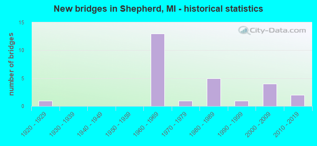
- New bridges - historical statistics
- 11920-1929
- 131960-1969
- 11970-1979
- 51980-1989
- 11990-1999
- 42000-2009
- 22010-2019

- Reconstructed bridges - Historical Statistics
- 11940-1949
- 01950-1959
- 01960-1969
- 01970-1979
- 01980-1989
- 11990-1999


- Bridge Condition - Deck
- 22.2%Very good
- 38.9%Good
- 27.8%Satisfactory
- 11.1%Fair

- Bridge Condition - Superstructure
- 33.3%Very good
- 27.8%Good
- 27.8%Satisfactory
- 5.6%Fair
- 5.6%Critical

- Bridge Condition - Substructure
- 33.3%Very good
- 38.9%Good
- 5.6%Satisfactory
- 11.1%Fair
- 5.6%Poor
- 5.6%Critical

- Bridge Condition - Channel
- 31.6%Very good
- 10.5%Good
- 42.1%Satisfactory
- 15.8%Fair

- Bridge Condition - Culverts
- 20.0%Very good
- 40.0%Satisfactory
- 40.0%Fair
Find on map >> Show street view
Structure Number: 1369, Location: 1/2 MI S OF MARENGO (Lat: 42.261456, Lng: -84.855289), Route carried "on" structure: County highway , Year Built: 1969, Status: Posted for load, Structure Length: 2.37m (7.78ft), Average Daily Traffic: 259 (year 1994), Truck Traffic: 5%, Average Future Daily Traffic: 483 (year 2024), Design Load: HS 20+Mod, Features Intersected: KALAMAZOO RIVER, Facility Carried by Structure: B DRIVE NORTH
Minimum Vertical Clearance: 30.48m (100.00ft), Kilometerpoint: 8.140, Lanes on structure: 2, Owner: County Highway Agency, Approaching Roadway Width: 8.8m (28.9ft), Material/Design: Wood or Timber, Design/Construction: Slab, Number Of Spans In Main Unit: 3, Length of Maximum Span: 7.9m (25.9ft), Curb-To-Curb Width: 8.6m (28.2ft), Out-to-Out Width: 9.0m (29.5ft)
Condition: Deck: Satisfactory, Superstructure: Satisfactory, Substructure: Satisfactory, Channel: Satisfactory, Operating Rating: 36.9 metric tons, Method Used To Determine Operating Rating: Allowable Stress (AS) rating reported by rating factor (RF) method using MS18 loading, Inventory Rating: 26.2 metric tons, Method Used To Determine Inventory Rating: Allowable Stress (AS) rating reported by rating factor (RF) method using MS18 loading, Structural Evaluation: Equal to present minimum criteria, Deck Geometry: Equal to present minimum criteria, Waterway Adequacy: Equal to present desirable criteria, Approach Roadway Alignment: Equal to present desirable criteria, Bridge Posting: Required (Relationship of Operating Rating to Maximum Legal Load: 30.0 - 39.9% below), Length Of Structure Improvement: 3.08m (10.10ft), Designated Inspection Frequency: Every 24 months, Inspection Date: September 2020, Deck Structure Type: Wood or Timber, Wearing Surface/Protective System: Wearing Surface: Bituminous, Deck Protection: Other
Find on map >> Show street view
Structure Number: 4225, Location: 4.7 MI N OF GRATIOT COL (Lat: 43.534500, Lng: -84.676661), Route carried "on" structure: US 127, Year Built: 1961, Status: Open, Structure Length: 1.52m (4.99ft), Average Daily Traffic: 10,457 (year 2007), Truck Traffic: 8%, Average Future Daily Traffic: 12,921 (year 2015), Design Load: HS 20, Features Intersected: LITTLE SALT RIVER
Minimum Vertical Clearance: 30.48m (100.00ft), Kilometerpoint: 7.606, Lanes on structure: 2, Base Highway Network: Yes (Inventory Route: 24, Subroute: 3), Owner: State Highway Agency, Approaching Roadway Width: 12.8m (42.0ft), Material/Design: Steel, Design/Construction: Stringer/Multi-beam, Number Of Spans In Main Unit: 1, Length of Maximum Span: 15.2m (49.9ft), Curb-To-Curb Width: 13.2m (43.3ft), Out-to-Out Width: 14.3m (46.9ft)
Condition: Deck: Satisfactory, Superstructure: Satisfactory, Substructure: Fair, Channel: Satisfactory, Operating Rating: 59.6 metric tons, Method Used To Determine Operating Rating: Load Factor (LF) rating reported by rating factor (RF) method using MS18 loading, Inventory Rating: 35.6 metric tons, Method Used To Determine Inventory Rating: Load Factor (LF) rating reported by rating factor (RF) method using MS18 loading, Structural Evaluation: Somewhat better than minimum adequacy, Deck Geometry: Superior to present desirable criteria, Waterway Adequacy: Equal to present desirable criteria, Approach Roadway Alignment: Equal to present desirable criteria, Designated Inspection Frequency: Every 24 months, Other Special Inspection Frequency: Every 12 months, Inspection Date: April 2021, Other Special Inspection Date: April 2021, Deck Structure Type: Concrete Cast-file-Place, Wearing Surface/Protective System: Wearing Surface: Latex Concrete
Find on map >> Show street view
Structure Number: 4226, Location: 4.7 MI N OF GRATIOT COL (Lat: 43.534489, Lng: -84.677025), Route carried "on" structure: US 127, Year Built: 1961, Status: Open, Structure Length: 1.52m (4.99ft), Average Daily Traffic: 10,457 (year 2007), Truck Traffic: 7%, Average Future Daily Traffic: 14,937 (year 2018), Design Load: HS 20, Features Intersected: LITTLE SALT RIVER
Minimum Vertical Clearance: 30.48m (100.00ft), Kilometerpoint: 7.609, Lanes on structure: 2, Base Highway Network: Yes (Inventory Route: 24, Subroute: 6), Owner: State Highway Agency, Approaching Roadway Width: 12.8m (42.0ft), Material/Design: Steel, Design/Construction: Stringer/Multi-beam, Number Of Spans In Main Unit: 1, Length of Maximum Span: 15.2m (49.9ft), Curb-To-Curb Width: 13.1m (43.0ft), Out-to-Out Width: 14.3m (46.9ft)
Condition: Deck: Fair, Superstructure: Satisfactory, Substructure: Poor, Channel: Satisfactory, Operating Rating: 59.6 metric tons, Method Used To Determine Operating Rating: Load Factor (LF) rating reported by rating factor (RF) method using MS18 loading, Inventory Rating: 35.6 metric tons, Method Used To Determine Inventory Rating: Load Factor (LF) rating reported by rating factor (RF) method using MS18 loading, Structural Evaluation: Meets minimum limits, Deck Geometry: Superior to present desirable criteria, Waterway Adequacy: Equal to present desirable criteria, Approach Roadway Alignment: Equal to present desirable criteria, Designated Inspection Frequency: Every 24 months, Other Special Inspection Frequency: Every 12 months, Inspection Date: April 2021, Other Special Inspection Date: April 2021, Deck Structure Type: Concrete Cast-file-Place, Wearing Surface/Protective System: Wearing Surface: Epoxy Overlay
Find on map >> Show street view
Structure Number: 423, Location: 1.0 MI N OF GRATIOT COL (Lat: 43.480614, Lng: -84.677733), Route carried "on" structure: County highway , Year Built: 1965, Status: Open, Structure Length: 6.34m (20.80ft), Average Daily Traffic: 300 (year 1974), Truck Traffic: 5%, Average Future Daily Traffic: 300 (year 1977), Design Load: H 15, Features Intersected: US-127, Facility Carried by Structure: COE RD
Minimum Vertical Clearance: 30.48m (100.00ft), Kilometerpoint: 5.597, Lanes on structure: 2, Lanes under structure: 4, Owner: State Highway Agency, Approaching Roadway Width: 10.3m (33.8ft), Material/Design: Prestressed concrete, Design/Construction: Stringer/Multi-beam, Number Of Spans In Main Unit: 4, Length of Maximum Span: 21.9m (71.9ft), Curb or Sidewalk Widths: Left: 0.7m (2.3ft), Right: 0.7m (2.3ft), Curb-To-Curb Width: 7.3m (24.0ft), Out-to-Out Width: 9.5m (31.2ft)
Condition: Deck: Good, Superstructure: Good, Substructure: Good, Operating Rating: 77.8 metric tons, Method Used To Determine Operating Rating: Load Factor (LF) rating reported by rating factor (RF) method using MS18 loading, Inventory Rating: 40.5 metric tons, Method Used To Determine Inventory Rating: Load Factor (LF) rating reported by rating factor (RF) method using MS18 loading, Structural Evaluation: Better than present minimum criteria, Deck Geometry: Somewhat better than minimum adequacy, Underclear: Somewhat better than minimum adequacy, Approach Roadway Alignment: Equal to present desirable criteria, Designated Inspection Frequency: Every 24 months, Inspection Date: March 2021, Deck Structure Type: Concrete Cast-file-Place, Wearing Surface/Protective System: Wearing Surface: Monolithic Concrete
Find on map >> Show street view
Structure Number: 4231, Location: 3.1 MI N OF GRATIOT COL (Lat: 43.509647, Lng: -84.676575), Route carried "on" structure: County highway , Year Built: 1964, Status: Open, Structure Length: 6.37m (20.90ft), Average Daily Traffic: 345 (year 1988), Truck Traffic: 3%, Average Future Daily Traffic: 120 (year 1977), Design Load: H 15, Features Intersected: US-127, Facility Carried by Structure: PLEASANT VALLEY RD
Minimum Vertical Clearance: 30.48m (100.00ft), Kilometerpoint: 26.946, Lanes on structure: 2, Lanes under structure: 4, Owner: State Highway Agency, Approaching Roadway Width: 10.3m (33.8ft), Material/Design: Prestressed concrete, Design/Construction: Stringer/Multi-beam, Number Of Spans In Main Unit: 4, Length of Maximum Span: 21.6m (70.9ft), Curb or Sidewalk Widths: Left: 0.7m (2.3ft), Right: 0.7m (2.3ft), Curb-To-Curb Width: 7.3m (24.0ft), Out-to-Out Width: 9.5m (31.2ft)
Condition: Deck: Good, Superstructure: Satisfactory, Substructure: Good, Operating Rating: 53.5 metric tons, Method Used To Determine Operating Rating: Load Factor (LF) rating reported by rating factor (RF) method using MS18 loading, Inventory Rating: 32.1 metric tons, Method Used To Determine Inventory Rating: Load Factor (LF) rating reported by rating factor (RF) method using MS18 loading, Structural Evaluation: Equal to present minimum criteria, Deck Geometry: Somewhat better than minimum adequacy, Underclear: Somewhat better than minimum adequacy, Approach Roadway Alignment: Better than present minimum criteria, Designated Inspection Frequency: Every 24 months, Inspection Date: Febuary 2022, Deck Structure Type: Concrete Cast-file-Place, Wearing Surface/Protective System: Wearing Surface: Monolithic Concrete
Find on map >> Show street view
Structure Number: 4232, Location: 4.1 MI N OF GRATIOT COL (Lat: 43.524167, Lng: -84.676667), Route carried "on" structure: County highway 3716, Year Built: 1960, Year Reconstructed: 1990, Status: Open, Structure Length: 6.28m (20.60ft), Average Daily Traffic: 580 (year 1974), Average Future Daily Traffic: 580 (year 1977), Design Load: HS 20, Features Intersected: US-127, Facility Carried by Structure: BLANCHARD RD
Minimum Vertical Clearance: 30.48m (100.00ft), Kilometerpoint: 33.348, Lanes on structure: 2, Lanes under structure: 4, Owner: State Highway Agency, Approaching Roadway Width: 12.2m (40.0ft), Material/Design: Steel, Design/Construction: Stringer/Multi-beam, Number Of Spans In Main Unit: 4, Length of Maximum Span: 21.6m (70.9ft), Curb-To-Curb Width: 7.9m (25.9ft), Out-to-Out Width: 10.0m (32.8ft)
Condition: Deck: Satisfactory, Superstructure: Satisfactory, Substructure: Good, Operating Rating: 62.2 metric tons, Method Used To Determine Operating Rating: Load Factor (LF) rating reported by rating factor (RF) method using MS18 loading, Inventory Rating: 37.3 metric tons, Method Used To Determine Inventory Rating: Load Factor (LF) rating reported by rating factor (RF) method using MS18 loading, Structural Evaluation: Equal to present minimum criteria, Deck Geometry: Somewhat better than minimum adequacy, Underclear: Equal to present minimum criteria, Approach Roadway Alignment: Better than present minimum criteria, Designated Inspection Frequency: Every 24 months, Inspection Date: April 2021, Deck Structure Type: Concrete Cast-file-Place, Wearing Surface/Protective System: Wearing Surface: Bituminous
Find on map >> Show street view
Structure Number: 4233, Location: 5.7 MI N OF GRATIOT COL (Lat: 43.544142, Lng: -84.687553), Route carried "on" structure: County highway 3783, Year Built: 1964, Status: Open, Structure Length: 7.04m (23.10ft), Average Daily Traffic: 2,600 (year 1974), Average Future Daily Traffic: 2,600 (year 1977), Design Load: H 15, Features Intersected: US-127, Facility Carried by Structure: SHEPHERD RD
Minimum Vertical Clearance: 30.48m (100.00ft), Kilometerpoint: 8.668, Lanes on structure: 2, Lanes under structure: 4, Owner: State Highway Agency, Approaching Roadway Width: 10.9m (35.8ft), Skew: 2 degrees, Material/Design: Steel, Design/Construction: Stringer/Multi-beam, Number Of Spans In Main Unit: 4, Length of Maximum Span: 24.0m (78.7ft), Curb or Sidewalk Widths: Left: 0.7m (2.3ft), Right: 0.7m (2.3ft), Curb-To-Curb Width: 8.5m (27.9ft), Out-to-Out Width: 10.7m (35.1ft)
Condition: Deck: Satisfactory, Superstructure: Good, Substructure: Good, Operating Rating: 51.5 metric tons, Method Used To Determine Operating Rating: Load Factor (LF) rating reported by rating factor (RF) method using MS18 loading, Inventory Rating: 27.5 metric tons, Method Used To Determine Inventory Rating: Load Factor (LF) rating reported by rating factor (RF) method using MS18 loading, Structural Evaluation: Equal to present minimum criteria, Deck Geometry: Meets minimum limits, Underclear: Equal to present minimum criteria, Approach Roadway Alignment: Better than present minimum criteria, Designated Inspection Frequency: Every 24 months, Inspection Date: April 2021, Bridge Improvement Cost: $110,000, Deck Structure Type: Concrete Cast-file-Place, Wearing Surface/Protective System: Wearing Surface: Monolithic Concrete
Find on map >> Show street view
Structure Number: 4277, Location: SEC 21 CHIPPEWA TWP (Lat: 43.582686, Lng: -84.669233), Route carried "on" structure: County highway 3732, Year Built: 1969, Status: Open, Structure Length: 1.00m (3.28ft), Average Daily Traffic: 2,019 (year 2015), Truck Traffic: 2%, Design Load: H 20, Features Intersected: POTTER CREEK DRAIN, Facility Carried by Structure: BROOMFIELD ROAD
Minimum Vertical Clearance: 30.48m (100.00ft), Kilometerpoint: 12.780, Lanes on structure: 2, Owner: County Highway Agency, Approaching Roadway Width: 10.4m (34.1ft), Material/Design: Steel, Design/Construction: Culvert, Number Of Spans In Main Unit: 1, Length of Maximum Span: 8.5m (27.9ft), Curb-To-Curb Width: 8.5m (27.9ft), Out-to-Out Width: 10.4m (34.1ft)
Condition: Channel: Fair, Culverts: Fair, Operating Rating: 49.9 metric tons, Method Used To Determine Operating Rating: Load Factor (LF) rating reported by rating factor (RF) method using MS18 loading, Inventory Rating: 29.8 metric tons, Method Used To Determine Inventory Rating: Load Factor (LF) rating reported by rating factor (RF) method using MS18 loading, Structural Evaluation: Somewhat better than minimum adequacy, Deck Geometry: Meets minimum limits, Waterway Adequacy: Equal to present desirable criteria, Approach Roadway Alignment: Equal to present desirable criteria, Designated Inspection Frequency: Every 24 months, Inspection Date: May 2020, Wearing Surface/Protective System: Wearing Surface: Bituminous
Find on map >> Show street view
Structure Number: 4304, Location: 0.3 M N SW COR SEC 25 T13 (Lat: 43.485181, Lng: -84.746986), Route carried "on" structure: County highway , Year Built: 2018, Status: Open, Structure Length: 1.58m (5.18ft), Average Daily Traffic: 762 (year 2017), Truck Traffic: 4%, Average Future Daily Traffic: 1,249 (year 2037), Design Load: Greater than HL93, Features Intersected: LITTLE SALT RIVER, Facility Carried by Structure: ISABELLA ROAD
Minimum Vertical Clearance: 30.48m (100.00ft), Kilometerpoint: 2.105, Lanes on structure: 2, Owner: County Highway Agency, Approaching Roadway Width: 9.4m (30.8ft), Material/Design: Prestressed concrete, Design/Construction: Box Beam or Girders - Multiple, Number Of Spans In Main Unit: 1, Length of Maximum Span: 15.5m (50.9ft), Curb-To-Curb Width: 9.5m (31.2ft), Out-to-Out Width: 10.5m (34.4ft)
Condition: Deck: Very good, Superstructure: Very good, Substructure: Very good, Channel: Very good, Operating Rating: 77.4 metric tons, Method Used To Determine Operating Rating: Load and Resistance Factor Rating (LRFR) rating reported by rating factor(RF) method using HL-93 loadings, Inventory Rating: 59.9 metric tons, Method Used To Determine Inventory Rating: Load and Resistance Factor Rating (LRFR) rating reported by rating factor(RF) method using HL-93 loadings, Structural Evaluation: Equal to present desirable criteria, Deck Geometry: Equal to present minimum criteria, Waterway Adequacy: Better than present minimum criteria, Approach Roadway Alignment: Better than present minimum criteria, Designated Inspection Frequency: Every 24 months, Inspection Date: June 2020, Deck Structure Type: Concrete Cast-file-Place, Wearing Surface/Protective System: Wearing Surface: Monolithic Concrete, Deck Protection: Epoxy Coated Reinforcing
Find on map >> Show street view
Structure Number: 4312, Location: 0.02M S NE COR SEC 32 T14 (Lat: 43.567192, Lng: -84.687692), Route carried "on" structure: County highway 3783, Year Built: 1998, Status: Open, Structure Length: 1.83m (6.00ft), Average Daily Traffic: 2,402 (year 2018), Truck Traffic: 10%, Average Future Daily Traffic: 2,932 (year 2038), Design Load: HS 20, Features Intersected: POTTER CREEK, Facility Carried by Structure: SHEPHERD ROAD
Minimum Vertical Clearance: 30.48m (100.00ft), Kilometerpoint: 11.227, Lanes on structure: 2, Owner: County Highway Agency, Approaching Roadway Width: 9.1m (29.9ft), Skew: 3 degrees, Material/Design: Prestressed concrete, Design/Construction: Box Beam or Girders - Multiple, Number Of Spans In Main Unit: 1, Length of Maximum Span: 18.3m (60.0ft), Curb-To-Curb Width: 9.5m (31.2ft), Out-to-Out Width: 9.5m (31.2ft)
Condition: Deck: Good, Superstructure: Good, Substructure: Very good, Channel: Good, Operating Rating: 70.9 metric tons, Method Used To Determine Operating Rating: Load Factor (LF), Inventory Rating: 42.5 metric tons, Method Used To Determine Inventory Rating: Load Factor (LF), Structural Evaluation: Better than present minimum criteria, Deck Geometry: Meets minimum limits, Waterway Adequacy: Better than present minimum criteria, Approach Roadway Alignment: Equal to present desirable criteria, Designated Inspection Frequency: Every 24 months, Inspection Date: April 2020, Deck Structure Type: Concrete Cast-file-Place, Wearing Surface/Protective System: Wearing Surface: Epoxy Overlay, Deck Protection: Epoxy Coated Reinforcing
Find on map >> Show street view
Structure Number: 4314, Location: 0.2 M S NE COR SEC 20 T13 (Lat: 43.505806, Lng: -84.687397), Route carried "on" structure: County highway 3781, Year Built: 1926, Year Reconstructed: 1947, Status: Open, Structure Length: 1.22m (4.00ft), Average Daily Traffic: 1,430 (year 2002), Average Future Daily Traffic: 2,120 (year 2022), Design Load: H 20, Features Intersected: LITTLE SALT RIVER, Facility Carried by Structure: SHEPHERD ROAD
Minimum Vertical Clearance: 30.48m (100.00ft), Kilometerpoint: 4.410, Lanes on structure: 2, Owner: County Highway Agency, Approaching Roadway Width: 11.0m (36.1ft), Material/Design: Steel, Design/Construction: Stringer/Multi-beam, Number Of Spans In Main Unit: 1, Length of Maximum Span: 10.6m (34.8ft), Curb or Sidewalk Widths: Left: 0.9m (3.0ft), Right: 0.9m (3.0ft), Curb-To-Curb Width: 10.1m (33.1ft), Out-to-Out Width: 12.0m (39.4ft)
Condition: Deck: Fair, Superstructure: Fair, Substructure: Fair, Channel: Fair, Operating Rating: 52.7 metric tons, Method Used To Determine Operating Rating: Load Factor (LF), Inventory Rating: 31.6 metric tons, Method Used To Determine Inventory Rating: Load Factor (LF), Structural Evaluation: Somewhat better than minimum adequacy, Deck Geometry: Somewhat better than minimum adequacy, Waterway Adequacy: Better than present minimum criteria, Approach Roadway Alignment: Equal to present desirable criteria, Designated Inspection Frequency: Every 12 months, Inspection Date: May 2021, Deck Structure Type: Concrete Cast-file-Place, Wearing Surface/Protective System: Wearing Surface: Bituminous, Membrane: Other
Find on map >> Show street view
Structure Number: 432, Location: SEC 27-34 CHIPPEWA TWP (Lat: 43.568117, Lng: -84.660731), Route carried "on" structure: ServiceCounty highway , Year Built: 1983, Status: Open, Structure Length: 1.22m (4.00ft), Average Daily Traffic: 175 (year 2002), Average Future Daily Traffic: 214 (year 2022), Design Load: HS 20, Features Intersected: POTTER CREEK, Facility Carried by Structure: DEERFIELD ROAD
Minimum Vertical Clearance: 30.48m (100.00ft), Kilometerpoint: 6.156, Lanes on structure: 2, Owner: County Highway Agency, Approaching Roadway Width: 6.7m (22.0ft), Material/Design: Prestressed concrete, Design/Construction: Box Beam or Girders - Multiple, Number Of Spans In Main Unit: 1, Length of Maximum Span: 12.2m (40.0ft), Curb-To-Curb Width: 8.5m (27.9ft), Out-to-Out Width: 9.5m (31.2ft)
Condition: Deck: Very good, Superstructure: Very good, Substructure: Very good, Channel: Good, Operating Rating: 95.7 metric tons, Method Used To Determine Operating Rating: Load Factor (LF), Inventory Rating: 57.3 metric tons, Method Used To Determine Inventory Rating: Load Factor (LF), Structural Evaluation: Equal to present desirable criteria, Waterway Adequacy: Equal to present desirable criteria, Approach Roadway Alignment: Equal to present desirable criteria, Designated Inspection Frequency: Every 24 months, Inspection Date: May 2020, Deck Structure Type: Concrete Cast-file-Place, Wearing Surface/Protective System: Wearing Surface: Monolithic Concrete, Membrane: Epoxy, Deck Protection: Epoxy Coated Reinforcing
Find on map >> Show street view
Structure Number: 4329, Location: SEC 30-31 COE TWP (Lat: 43.480736, Lng: -84.720592), Route carried "on" structure: ServiceCounty highway , Year Built: 1980, Status: Open, Structure Length: 0.97m (3.18ft), Average Daily Traffic: 196 (year 2002), Average Future Daily Traffic: 240 (year 2022), Design Load: HS 20, Features Intersected: LITTLE SALT RIVER, Facility Carried by Structure: COE ROAD
Minimum Vertical Clearance: 30.48m (100.00ft), Kilometerpoint: 2.131, Lanes on structure: 2, Owner: County Highway Agency, Approaching Roadway Width: 8.5m (27.9ft), Material/Design: Wood or Timber, Design/Construction: Slab, Number Of Spans In Main Unit: 2, Length of Maximum Span: 4.8m (15.7ft), Curb-To-Curb Width: 9.1m (29.9ft), Out-to-Out Width: 9.6m (31.5ft)
Condition: Deck: Good, Superstructure: Good, Substructure: Good, Channel: Fair, Operating Rating: 42.4 metric tons, Method Used To Determine Operating Rating: Allowable Stress (AS), Inventory Rating: 31.0 metric tons, Method Used To Determine Inventory Rating: Allowable Stress (AS), Structural Evaluation: Better than present minimum criteria, Deck Geometry: Equal to present minimum criteria, Waterway Adequacy: Better than present minimum criteria, Approach Roadway Alignment: Equal to present desirable criteria, Designated Inspection Frequency: Every 24 months, Inspection Date: May 2020, Deck Structure Type: Wood or Timber, Wearing Surface/Protective System: Wearing Surface: Bituminous
Find on map >> Show street view
Structure Number: 433, Location: .25 M W NE COR SEC 29 T13 (Lat: 43.495167, Lng: -84.692283), Route carried "on" structure: County highway , Year Built: 2007, Status: Open, Structure Length: 1.37m (4.49ft), Average Daily Traffic: 242 (year 2005), Average Future Daily Traffic: 374 (year 2027), Design Load: HS 20, Features Intersected: LITTLE SALT RIVER, Facility Carried by Structure: FREMONT ROAD
Minimum Vertical Clearance: 30.48m (100.00ft), Kilometerpoint: 4.437, Lanes on structure: 2, Owner: County Highway Agency, Approaching Roadway Width: 9.1m (29.9ft), Material/Design: Prestressed concrete, Design/Construction: Box Beam or Girders - Multiple, Number Of Spans In Main Unit: 1, Length of Maximum Span: 12.5m (41.0ft), Curb-To-Curb Width: 9.8m (32.2ft), Out-to-Out Width: 10.5m (34.4ft)
Condition: Deck: Good, Superstructure: Very good, Substructure: Very good, Channel: Satisfactory, Operating Rating: 79.6 metric tons, Method Used To Determine Operating Rating: Load Factor (LF), Inventory Rating: 47.7 metric tons, Method Used To Determine Inventory Rating: Load Factor (LF), Structural Evaluation: Equal to present desirable criteria, Deck Geometry: Better than present minimum criteria, Waterway Adequacy: Equal to present desirable criteria, Approach Roadway Alignment: Better than present minimum criteria, Designated Inspection Frequency: Every 24 months, Inspection Date: May 2021, Deck Structure Type: Concrete Cast-file-Place, Wearing Surface/Protective System: Wearing Surface: Monolithic Concrete, Deck Protection: Epoxy Coated Reinforcing
Find on map >> Show street view
Structure Number: 4331, Location: SEC 16-21 COE TWP (Lat: 43.509703, Lng: -84.686761), Route carried "on" structure: ServiceCounty highway , Year Built: 1989, Status: Open, Structure Length: 1.46m (4.79ft), Average Daily Traffic: 511 (year 2005), Average Future Daily Traffic: 539 (year 2022), Design Load: HS 20+Mod, Features Intersected: LITTLE SALT RIVER, Facility Carried by Structure: PLEASANT VALLEY RD
Minimum Vertical Clearance: 30+ m (98+ ft), Kilometerpoint: 26.122, Lanes on structure: 2, Owner: County Highway Agency, Approaching Roadway Width: 9.1m (29.9ft), Material/Design: Prestressed concrete, Design/Construction: Box Beam or Girders - Multiple, Number Of Spans In Main Unit: 1, Length of Maximum Span: 13.4m (44.0ft), Curb-To-Curb Width: 9.1m (29.9ft), Out-to-Out Width: 9.4m (30.8ft)
Condition: Deck: Very good, Superstructure: Good, Substructure: Good, Channel: Very good, Operating Rating: 68.8 metric tons, Method Used To Determine Operating Rating: Load Factor (LF), Inventory Rating: 41.3 metric tons, Method Used To Determine Inventory Rating: Load Factor (LF), Structural Evaluation: Better than present minimum criteria, Deck Geometry: Equal to present minimum criteria, Waterway Adequacy: Equal to present desirable criteria, Approach Roadway Alignment: Equal to present desirable criteria, Designated Inspection Frequency: Every 24 months, Inspection Date: May 2020, Deck Structure Type: Concrete Precast Panels, Wearing Surface/Protective System: Wearing Surface: Bituminous, Membrane: Other
Find on map >> Show street view
Structure Number: 4332, Location: SEC 2-11 COE TWP (Lat: 43.538678, Lng: -84.629167), Route carried "on" structure: ServiceCounty highway , Year Built: 1980, Status: Posted for load, Structure Length: 1.73m (5.68ft), Average Daily Traffic: 198 (year 2004), Average Future Daily Traffic: 301 (year 2024), Design Load: H 20, Features Intersected: LITTLE SALT RIVER, Facility Carried by Structure: WALTON ROAD
Minimum Vertical Clearance: 30.48m (100.00ft), Kilometerpoint: 3.940, Lanes on structure: 2, Owner: County Highway Agency, Approaching Roadway Width: 9.1m (29.9ft), Material/Design: Steel, Design/Construction: Stringer/Multi-beam, Number Of Spans In Main Unit: 1, Length of Maximum Span: 16.7m (54.8ft), Curb-To-Curb Width: 9.4m (30.8ft), Out-to-Out Width: 9.4m (30.8ft)
Condition: Deck: Satisfactory, Superstructure: Critical, Substructure: Critical, Channel: Satisfactory, Operating Rating: 9.4 metric tons, Method Used To Determine Operating Rating: Load Factor (LF) rating reported by rating factor (RF) method using MS18 loading, Inventory Rating: 5.8 metric tons, Method Used To Determine Inventory Rating: Load Factor (LF) rating reported by rating factor (RF) method using MS18 loading, Structural Evaluation: High priority of replacement, Deck Geometry: Equal to present minimum criteria, Waterway Adequacy: Better than present minimum criteria, Approach Roadway Alignment: Somewhat better than minimum adequacy, Bridge Posting: Required (Relationship of Operating Rating to Maximum Legal Load: > 39.9% below), Designated Inspection Frequency: Every 12 months, Inspection Date: May 2021, Deck Structure Type: Corrugated Steel, Wearing Surface/Protective System: Wearing Surface: Bituminous
Find on map >> Show street view
Structure Number: 4333, Location: 0.5 M S NW COR SEC 29 COE (Lat: 43.486747, Lng: -84.707292), Route carried "on" structure: County highway , Year Built: 1970, Status: Open, Structure Length: 0.92m (3.02ft), Average Daily Traffic: 181 (year 2002), Average Future Daily Traffic: 220 (year 2022), Design Load: H 20, Features Intersected: LITTLE SALT RIVER, Facility Carried by Structure: LEATON ROAD
Minimum Vertical Clearance: 30.48m (100.00ft), Kilometerpoint: 2.290, Lanes on structure: 2, Owner: County Highway Agency, Approaching Roadway Width: 7.3m (24.0ft), Material/Design: Steel, Design/Construction: Culvert, Number Of Spans In Main Unit: 2, Length of Maximum Span: 4.2m (13.8ft), Curb-To-Curb Width: 7.3m (24.0ft), Out-to-Out Width: 7.9m (25.9ft)
Condition: Channel: Satisfactory, Culverts: Fair, Operating Rating: 43.6 metric tons, Method Used To Determine Operating Rating: Allowable Stress (AS), Inventory Rating: 32.7 metric tons, Method Used To Determine Inventory Rating: Allowable Stress (AS), Structural Evaluation: Somewhat better than minimum adequacy, Deck Geometry: Somewhat better than minimum adequacy, Waterway Adequacy: Somewhat better than minimum adequacy, Approach Roadway Alignment: Better than present minimum criteria, Designated Inspection Frequency: Every 24 months, Inspection Date: May 2020, Wearing Surface/Protective System: Wearing Surface: Gravel
Find on map >> Show street view
Structure Number: 4334, Location: SEC 1-2 COE TWP (Lat: 43.541511, Lng: -84.627667), Route carried "on" structure: ServiceCounty highway , Year Built: 2008, Status: Open, Structure Length: 2.44m (8.01ft), Average Daily Traffic: 72 (year 2008), Average Future Daily Traffic: 261 (year 2025), Features Intersected: LITTLE SALT RIVER, Facility Carried by Structure: CHIPPEWA ROAD
Minimum Vertical Clearance: 30.48m (100.00ft), Kilometerpoint: 8.383, Lanes on structure: 2, Owner: County Highway Agency, Approaching Roadway Width: 9.8m (32.2ft), Skew: 1 degrees, Material/Design: Prestressed concrete, Design/Construction: Box Beam or Girders - Multiple, Number Of Spans In Main Unit: 1, Length of Maximum Span: 23.2m (76.1ft), Curb-To-Curb Width: 9.8m (32.2ft), Out-to-Out Width: 10.5m (34.4ft)
Condition: Deck: Good, Superstructure: Very good, Substructure: Good, Channel: Very good, Operating Rating: 90.4 metric tons, Method Used To Determine Operating Rating: Load Factor (LF), Inventory Rating: 54.1 metric tons, Method Used To Determine Inventory Rating: Load Factor (LF), Structural Evaluation: Better than present minimum criteria, Deck Geometry: Equal to present desirable criteria, Waterway Adequacy: Equal to present desirable criteria, Approach Roadway Alignment: Equal to present desirable criteria, Designated Inspection Frequency: Every 24 months, Inspection Date: May 2020, Deck Structure Type: Concrete Cast-file-Place, Wearing Surface/Protective System: Wearing Surface: Monolithic Concrete, Deck Protection: Epoxy Coated Reinforcing
Find on map >> Show street view
Structure Number: 4381, Location: IN SHEPHERD (Lat: 43.524228, Lng: -84.683622), Route carried "on" structure: County highway 3716, Year Built: 1961, Status: Open, Structure Length: 1.61m (5.28ft), Average Daily Traffic: 1,800 (year 1997), Average Future Daily Traffic: 3,280 (year 2017), Design Load: HS 20+Mod, Features Intersected: LITTLE SALT RIVER, Facility Carried by Structure: BLANCHARD ROAD
Minimum Vertical Clearance: 30.48m (100.00ft), Kilometerpoint: 32.787, Lanes on structure: 2, Owner: City or Municipal Highway Agency, Approaching Roadway Width: 9.1m (29.9ft), Material/Design: Steel, Design/Construction: Culvert, Number Of Spans In Main Unit: 3, Length of Maximum Span: 4.8m (15.7ft), Out-to-Out Width: 13.3m (43.6ft)
Condition: Channel: Satisfactory, Culverts: Satisfactory, Operating Rating: 97.2 metric tons, Method Used To Determine Operating Rating: Load Factor (LF) rating reported by rating factor (RF) method using MS18 loading, Inventory Rating: 94.9 metric tons, Method Used To Determine Inventory Rating: Load Factor (LF) rating reported by rating factor (RF) method using MS18 loading, Structural Evaluation: Equal to present minimum criteria, Waterway Adequacy: Meets minimum limits, Approach Roadway Alignment: Equal to present desirable criteria, Designated Inspection Frequency: Every 24 months, Inspection Date: July 2020
Find on map >> Show street view
Structure Number: 12676, Location: 0.1 MS NW SEC 25 LINCOLN (Lat: 43.495131, Lng: -84.747125), Route carried "on" structure: County highway , Year Built: 2017, Status: Open, Structure Length: 1.34m (4.40ft), Average Daily Traffic: 645 (year 2016), Truck Traffic: 4%, Average Future Daily Traffic: 1,057 (year 2036), Design Load: Greater than HL93, Features Intersected: LITTLE SALT RIVER, Facility Carried by Structure: ISABELLA ROAD
Minimum Vertical Clearance: 30.48m (100.00ft), Kilometerpoint: 3.209, Lanes on structure: 2, Owner: County Highway Agency, Approaching Roadway Width: 9.4m (30.8ft), Material/Design: Prestressed concrete, Design/Construction: Box Beam or Girders - Multiple, Number Of Spans In Main Unit: 1, Length of Maximum Span: 13.0m (42.7ft), Curb-To-Curb Width: 9.5m (31.2ft), Out-to-Out Width: 10.5m (34.4ft)
Condition: Deck: Very good, Superstructure: Very good, Substructure: Very good, Channel: Very good, Operating Rating: 69.0 metric tons, Method Used To Determine Operating Rating: Load and Resistance Factor Rating (LRFR) rating reported by rating factor(RF) method using HL-93 loadings, Inventory Rating: 61.9 metric tons, Method Used To Determine Inventory Rating: Load and Resistance Factor Rating (LRFR) rating reported by rating factor(RF) method using HL-93 loadings, Structural Evaluation: Equal to present desirable criteria, Deck Geometry: Equal to present minimum criteria, Waterway Adequacy: Equal to present desirable criteria, Approach Roadway Alignment: Equal to present desirable criteria, Designated Inspection Frequency: Every 24 months, Inspection Date: July 2021, Deck Structure Type: Concrete Cast-file-Place, Wearing Surface/Protective System: Wearing Surface: Monolithic Concrete, Deck Protection: Epoxy Coated Reinforcing
Find on map >> Show street view
Structure Number: 1313, Location: 200' E OF GENUINE RD (Lat: 43.582669, Lng: -84.677222), Route carried "on" structure: County highway , Year Built: 1986, Status: Open, Structure Length: 0.67m (2.20ft), Average Daily Traffic: 2,019 (year 2015), Truck Traffic: 2%, Average Future Daily Traffic: 2,464 (year 2035), Design Load: HS 20, Features Intersected: POTTER CREEK, Facility Carried by Structure: BROOMFIELD RD
Minimum Vertical Clearance: 30.48m (100.00ft), Kilometerpoint: 12.135, Lanes on structure: 2, Owner: County Highway Agency, Approaching Roadway Width: 10.4m (34.1ft), Skew: 1 degrees, Material/Design: Concrete, Design/Construction: Culvert, Number Of Spans In Main Unit: 1, Length of Maximum Span: 6.1m (20.0ft), Curb-To-Curb Width: 9.8m (32.2ft), Out-to-Out Width: 15.8m (51.8ft)
Condition: Channel: Satisfactory, Culverts: Satisfactory, Operating Rating: 43.6 metric tons, Method Used To Determine Operating Rating: Field evaluation and documented engineering judgment, Inventory Rating: 32.7 metric tons, Method Used To Determine Inventory Rating: Field evaluation and documented engineering judgment, Structural Evaluation: Equal to present minimum criteria, Deck Geometry: Meets minimum limits, Waterway Adequacy: Somewhat better than minimum adequacy, Approach Roadway Alignment: Equal to present desirable criteria, Designated Inspection Frequency: Every 24 months, Inspection Date: May 2020, Deck Structure Type: Concrete Cast-file-Place, Wearing Surface/Protective System: Wearing Surface: Bituminous
Find on map >> Show street view
Structure Number: 13159, Location: 0.5 MI S OF COE RD (Lat: 43.473533, Lng: -84.726822), Route carried "on" structure: County highway , Year Built: 2007, Status: Open, Structure Length: 1.37m (4.49ft), Average Daily Traffic: 45 (year 2005), Average Future Daily Traffic: 87 (year 2027), Design Load: HS 20, Features Intersected: LITTLE SALT RIVER, Facility Carried by Structure: SUMMERTON ROAD
Minimum Vertical Clearance: 30.48m (100.00ft), Kilometerpoint: 0.811, Lanes on structure: 2, Owner: County Highway Agency, Approaching Roadway Width: 9.1m (29.9ft), Material/Design: Prestressed concrete, Design/Construction: Box Beam or Girders - Multiple, Number Of Spans In Main Unit: 1, Length of Maximum Span: 12.5m (41.0ft), Curb-To-Curb Width: 9.8m (32.2ft), Out-to-Out Width: 10.5m (34.4ft)
Condition: Deck: Good, Superstructure: Very good, Substructure: Very good, Channel: Very good, Operating Rating: 79.6 metric tons, Method Used To Determine Operating Rating: Load Factor (LF), Inventory Rating: 47.7 metric tons, Method Used To Determine Inventory Rating: Load Factor (LF), Structural Evaluation: Equal to present desirable criteria, Deck Geometry: Equal to present desirable criteria, Waterway Adequacy: Equal to present desirable criteria, Approach Roadway Alignment: Equal to present desirable criteria, Designated Inspection Frequency: Every 24 months, Inspection Date: May 2021, Deck Structure Type: Concrete Cast-file-Place, Wearing Surface/Protective System: Wearing Surface: Monolithic Concrete, Deck Protection: Epoxy Coated Reinforcing
Find on map >> Show street view
Structure Number: 13393, Location: SEC 16 & 17 COE TWP (Lat: 43.510917, Lng: -84.687389), Route carried "on" structure: County highway , Year Built: 2007, Status: Open, Structure Length: 0.79m (2.59ft), Average Daily Traffic: 1,742 (year 2005), Truck Traffic: 3%, Average Future Daily Traffic: 2,589 (year 2025), Features Intersected: CHILDS CREEK, Facility Carried by Structure: SHEPHERD RD
Minimum Vertical Clearance: 30.48m (100.00ft), Kilometerpoint: 4.976, Lanes on structure: 2, Owner: County Highway Agency, Approaching Roadway Width: 7.3m (24.0ft), Material/Design: Concrete, Design/Construction: Culvert, Number Of Spans In Main Unit: 1, Length of Maximum Span: 7.3m (24.0ft), Curb-To-Curb Width: 11.0m (36.1ft), Out-to-Out Width: 18.3m (60.0ft)
Condition: Channel: Very good, Culverts: Very good, Operating Rating: 42.7 metric tons, Method Used To Determine Operating Rating: Field evaluation and documented engineering judgment, Inventory Rating: 32.6 metric tons, Method Used To Determine Inventory Rating: Field evaluation and documented engineering judgment, Structural Evaluation: Equal to present desirable criteria, Deck Geometry: Equal to present minimum criteria, Waterway Adequacy: Equal to present desirable criteria, Approach Roadway Alignment: Equal to present desirable criteria, Designated Inspection Frequency: Every 24 months, Inspection Date: May 2021, Wearing Surface/Protective System: Wearing Surface: Bituminous
Find on map >> Show street view
Structure Number: 423, Location: 1.0 MI N OF GRATIOT COL (Lat: 43.480614, Lng: -84.677733), Route carried "under" structure: US 127, Year Built: 1965, Structure Length: 0. m, Average Daily Traffic: 20,238 (year 2007), Truck Traffic: 8%, Features Intersected: US-127, Facility Carried by Structure: COE RD
Minimum Vertical Clearance: 4.47m (14.67ft), Kilometerpoint: 1.617, Lanes on structure: 2, Lanes under structure: 4, Material/Design: Prestressed concrete, Design/Construction: Stringer/Multi-beam, Length of Maximum Span: 21.9m (71.9ft)
Find on map >> Show street view
Structure Number: 4231, Location: 3.1 MI N OF GRATIOT COL (Lat: 43.509647, Lng: -84.676575), Route carried "under" structure: US 127, Year Built: 1964, Structure Length: 0. m, Average Daily Traffic: 20,238 (year 2007), Truck Traffic: 9%, Features Intersected: US-127, Facility Carried by Structure: PLEASANT VALLEY RD
Minimum Vertical Clearance: 4.47m (14.67ft), Kilometerpoint: 4.846, Lanes on structure: 2, Lanes under structure: 4, Material/Design: Prestressed concrete, Design/Construction: Stringer/Multi-beam, Length of Maximum Span: 21.6m (70.9ft)
Find on map >> Show street view
Structure Number: 4232, Location: 4.1 MI N OF GRATIOT COL (Lat: 43.524167, Lng: -84.676667), Route carried "under" structure: US 127, Year Built: 1960, Structure Length: 0. m, Average Daily Traffic: 20,914 (year 2007), Truck Traffic: 9%, Features Intersected: US-127, Facility Carried by Structure: BLANCHARD RD
Minimum Vertical Clearance: 5.21m (17.09ft), Kilometerpoint: 6.459, Lanes on structure: 2, Lanes under structure: 4, Material/Design: Steel, Design/Construction: Stringer/Multi-beam, Length of Maximum Span: 21.6m (70.9ft)
Find on map >> Show street view
Structure Number: 4233, Location: 5.7 MI N OF GRATIOT COL (Lat: 43.544142, Lng: -84.687553), Route carried "under" structure: US 127, Year Built: 1964, Structure Length: 0. m, Average Daily Traffic: 20,914 (year 2007), Truck Traffic: 7%, Features Intersected: US-127, Facility Carried by Structure: SHEPHERD RD
Minimum Vertical Clearance: 5.21m (17.09ft), Kilometerpoint: 9.072, Lanes on structure: 2, Lanes under structure: 4, Material/Design: Steel, Design/Construction: Stringer/Multi-beam, Length of Maximum Span: 24.0m (78.7ft)